
Administrative community Heustreu
| coat of arms | Germany map | |
|---|---|---|
 Help on coat of arms |
Coordinates: 50 ° 21 ' N , 10 ° 15' E |
|
| Basic data | ||
| State : | Bavaria | |
| Administrative region : | Lower Franconia | |
| County : | Rhön-Grabfeld | |
| Area : | 51.36 km 2 | |
| Residents: | 4997 (Dec. 31, 2019) | |
| Population density : | 97 inhabitants per km 2 | |
| License plate : | NES, CAN, MET | |
| Association key : | 09 6 73 5638 | |
| Association structure: | 4 municipalities | |
| Association administration address : |
Wetterstrasse 4 97618 Heustreu |
|
| Website : | ||
| Chairman : | Alois Gensler | |
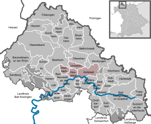
| Location of the Heustreu administrative community in the Rhön-Grabfeld district | ||
  |
||


In the Heustreu administrative community in the Lower Franconian district of Rhön-Grabfeld , the following communities have come together to handle their administrative business:
- Heustreu , 1291 inhabitants, 10.56 km²
- Hollstadt , 1439 inhabitants, 24.3 km²
- Unsleben , 906 inhabitants, 8.92 km²
- Wollbach , 1361 inhabitants, 7.58 km²
The administrative community is based in Heustreu.

Coat of arms of the community of Heustreu

Coat of arms of the municipality of Hollstadt
Coat of arms of the Unsleben community

Coat of arms of the municipality of Wollbach


Individual evidence
- ↑ "Data 2" sheet, Statistical Report A1200C 202041 Population of the municipalities, districts and administrative districts 1st quarter 2020 (population based on the 2011 census) ( help ).
Administrative communities in the Rhön-Grabfeld district
Bad Königshofen i.Grabfeld | Bad Neustadt adSaale | Fladungen | Haystack | Mellrichstadt | Ostheim vdRhön | Hall adSaale
Disbanded: Elstal