Rödelmaier
| coat of arms | Germany map | |
|---|---|---|

|
Coordinates: 50 ° 19 ′ N , 10 ° 17 ′ E |
|
| Basic data | ||
| State : | Bavaria | |
| Administrative region : | Lower Franconia | |
| County : | Rhön-Grabfeld | |
| Management Community : | Bad Neustadt an der Saale | |
| Height : | 344 m above sea level NHN | |
| Area : | 6.28 km 2 | |
| Residents: | 964 (Dec. 31, 2019) | |
| Population density : | 153 inhabitants per km 2 | |
| Postal code : | 97618 | |
| Area code : | 09771 | |
| License plate : | NES, CAN, MET | |
| Community key : | 09 6 73 156 | |
| Community structure: | 1 district | |
| Association administration address: | Goethestr. 1 97616 Bad Neustadt adSaale |
|
| Website : | ||
| Mayor : | Michael Pöhnlein (new list) | |
| Location of the community Rödelmaier in the district of Rhön-Grabfeld | ||
Rödelmaier is a municipality in the Lower Franconian district of Rhön-Grabfeld and a member of the Bad Neustadt an der Saale administrative community .
geography
Rödelmaier is located in the Main-Rhön region .
There is only the Rödelmaier district .
history
Until the church is planted
The former office, which was controversial between the bishopric of Würzburg and the barons of Lochner zu Hüttenbach, was left to Grand Duke Ferdinand of Tuscany to form the Grand Duchy of Würzburg in 1805 after the secularization of the Hochstiftischen part in 1805 in favor of Bavaria . The property of the Barons von Lochner was mediatized in 1806. In 1814 the place became part of Bavaria . In the course of the administrative reforms in Bavaria, today's municipality was created with the municipal edict of 1818 .
Population development
- 1970: 682 inhabitants
- 1987: 752 inhabitants
- 1991: 799 inhabitants
- 1995: 934 inhabitants
- 2000: 933 inhabitants
- 2005: 937 inhabitants
- 2010: 942 inhabitants
- 2015: 927 inhabitants
politics
Mayor is Michael Pöhnlein (new list). He was elected in 2008 and confirmed in office in 2014.
The municipal council consists of eight members, four of whom belong to the New List and four to the Free Voting Community .
coat of arms
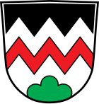
Blazon : "In silver, under black tips, a red zigzag bar above a green three-point shield ."
Architectural monuments
Economy and Infrastructure
Economy including agriculture and forestry
In 1998, according to official statistics, there were no employees in the manufacturing sector and no employees in the trade and transport sector at the place of work. In other economic sectors, four people were employed at the place of work subject to social security contributions. There were a total of 358 employees at the place of residence subject to social security contributions. There was one company in the manufacturing sector and one company in the main construction sector. In addition, in 1999 there were eight agricultural holdings with an agriculturally used area of 153 ha, of which 135 ha were arable land.
education
The following institutions exist (as of: 1999):
- A day-care center with 74 places and 54 children, including 19 children under the age of three
Sons and daughters of the church
- Joseph Sachs (1816–1868), educator, father of Samuel Sachs (1851–1935), co-partner in the American banking house Goldman Sachs, which was renamed because of him, introduced the issue of shares.
Web links
- Entry on Rödelmaier's coat of arms in the database of the House of Bavarian History
Individual evidence
- ↑ "Data 2" sheet, Statistical Report A1200C 202041 Population of the municipalities, districts and administrative districts 1st quarter 2020 (population based on the 2011 census) ( help ).
- ↑ http://www.wahlen.bayern.de/kommunalwahlen/
- ↑ Bavaria's municipalities - Rödelmaier municipality. House of Bavarian History, accessed on August 22, 2017 .


