
Black moor
The Black Moor is located in the Bavarian Rhon at the border triangle of Hesse , Thuringia and Bavaria and is part of the 243,323-hectare UNESCO - Biosphere Reserve Rhön . The wetland is 66.4 hectares of the largest bog complex of fens and a largely untouched and intact bog in Rhon. It is part of the Europe-wide nature reserve system Natura 2000 and one of the most important raised bogs in Central Europe . The Black Moor lies on the watershed between the Rhine and the Weser . In 2007 the moor was included in the list of the 100 most beautiful geotopes in Bavaria .
The Black Moor is an eccentric , dome-shaped hollowed bog. Its surface shape corresponds to the Nordic Kermimooren . From the central plateau, shifted to the upper edge in the north, with a peat thickness of sometimes over eight meters, the surface slopes down on all sides. The central plateau forms an approximately rectangular area, with a length of about 800 meters in a northwest-southeast direction and a width of about 400 meters. On the most steeply inclined surfaces, flarks, which are arranged parallel to the contour lines, appear, which are elongated, sharply delimited bends . These are up to 50 meters long and between one and three meters deep.
Coordinates: 50 ° 30 ′ 51 ″ N , 10 ° 3 ′ 54 ″ E


location

The Black Moor is in the district of the Lower Franconian municipality of Hausen , six kilometers from Fladungen on the Hochrhönstrasse and on the state road (ST 2287) coming from Seiferts , one kilometer southeast of the border with Thuringia and two kilometers east of the border with Hesse. It lies 770 to 782 meters above sea level in a flat hollow in the upper slope of the 805 meter high Querenberg, which slopes slightly to the south-east and whose summit is about one kilometer to the west.
The moor drains mainly through the ice trench 12 meters below in the south. This flows into the six kilometers east and 400 meters below scattering and thus into the river system of the Rhine . Another outflow enters the Hessian Ulster , which flows three kilometers to the west and almost 300 meters below and is part of the Weser river system.
Names

The black moor is next to the red moor one of the large moors of the Hochrhön, whose name, according to tradition, is derived from the color of the original plant cover. The parish co-operator of Simmershausen , Franz Anton Jäger, an avid natural scientist , wrote in his 1803 published letters about the Hohe Rhoene Franconia that the black moor is much more humid than the red moor. That is why the red magellan peat moss (Sphagnum magellanicum) , which also grows in the Black Moor , and which gave the Red Moor its name, would spoil again when it germinated, and then turn black, which is why the moor is called the Black Moor. At the present time one can still be satisfied with this explanation of the naming.
Emergence


The Black Moor, like the other high moors in the Rhön, was formed about 12,000 years ago after the last Ice Age .
In today's Rhön, clayey sediments were deposited in the Tertiary . Volcanoes produced extensive lava flows 25 to 18 million years ago , which solidified into weather-resistant basalt . During the last ice age, the Rhön was in the periglacial area , so it was not covered by glaciers. It resulted from Firnerosion and floor tiles large slope hollows. In areas in which they sealed the hollows with water-retaining sediments such as clays or loamy weathering residues of the basalts, rain bogs could form over low bog stages. The climatic conditions with high amounts of precipitation and low soil temperatures favored the growth of the bog. The other high moors of the Rhön are the Rote Moor (50 hectares), the Large Moor (eight hectares) and Small Moor (two hectares) on the Stirnberg , as well as the Moorlein on the Rasenberg. The pollen analyzes allowed the development to be traced back to the La Tène period .

Depressions such as Flarken and Kolke , which run through the peat area, are characteristic of the Black Moor . These are pools of water that are sometimes up to two meters deep and change their shape and size. The flarken - cracks in the moor vegetation - are formed by the movement of the moor, comparable to the ice of a glacier . This frequency of Flarken occurs neither in the second largest bog in the Rhön, the Red Moor, nor in other bogs in Central Europe. The depressions alternate with Bulte , which is known as the Bult-Schlenken complex . The ponds, also known as moor eyes or blanks , are a special feature of the Black Moor. In other raised bogs, these bog eyes are often located in the central parts of the raised bog, but in the black bog they are on the edge of the central plateau. The origin of these bog eyes has not yet been fully researched. The largest of the three pools near the boardwalk has an area of almost 500 square meters and a water depth of around 2.5 meters. This is followed by a 1.5 meter thick layer of peat mud that hits the clay underlay at a depth of four meters. The water in the bog eye is poor in nutrients and acidic. The dark brown color is caused by dissolved humus substances .
climate

The climate around the Black Moor and the Lange Rhön is rough and cold. The Rhön foreland, which is 300 to 500 meters lower, had annual mean temperatures of seven to eight degrees Celsius from 1961 to 1990 . The Hochrhön forms a cold island and has annual mean temperatures of 4.8 degrees Celsius ( Wasserkuppe ). Frankenheim , three kilometers to the north, had an annual mean temperature of 5.3 degrees Celsius and an annual rainfall of 938 millimeters at a slightly lower altitude than the Schwarze Moor . The Rhönhof, one kilometer to the east, at the same altitude, recorded annual rainfall of over 1,000 millimeters.
The Hochrhön is characterized by a snow cover of up to 110 days and a short summer vegetation period from May to October. The main growing season only lasts from July to mid-September. The temperature conditions limit the plant growth considerably. In addition, there are up to 200 foggy days and a high number of days with hoarfrost formation . The Lange Rhön and the Black Moor show high values compared to their surroundings with in some cases over 1000 millimeters of precipitation. The black moor represents another cold island within this high-altitude area. At night, cold air and frost can form on the open areas of this altitude at any time of the year .
Flora and vegetation

Depending on the shape of the surface, the moor is divided into different vegetation zones. Each one has special nutrient and water conditions and has its own typical plant community , most of which are endangered or threatened with extinction. At the edge of the Black Moor there is a spruce forest that was planted by the Reich Labor Service . According to the plans of the Association of Nature Park and Biosphere Reserve Bayerische Rhön e. V. in cooperation with the Bavarian Ministry of the Environment , this forest is to be gradually reduced to natural soft-leaf forest vegetation such as the Carpathian birch . The Carpathian birch, a special mountain subspecies of the bog birch , is one of the most distinctive tree species in the moor landscape and forms a forest on the edge of the moor. This tree species is striking because of its bizarre growth.
The next vegetation zone is the fen , a swamp belt with characteristic grass vegetation surrounding the moor in varying widths. Kleinseggenriede ( sheath cottongrass , narrow-leaved cottongrass , gray sedge , dog ostrich grass , swamp blood-eye , swamp bedstraw , swamp thistle , fever clover ) thrive there because the water running off from the bog mixes with the surface water and the high groundwater of the mineral Mixed soils in the area. This increases the supply of nutrients compared to the central moorland. Further inwards is the moor border slope with small trees and bushes (moor birch, pine , bogberry , blueberry , heather , black crowberry , common cranberry ). Due to the clear gradient, this area is the driest area within the moor compared to the almost flat plateau.
- Flora and vegetation in the Black Moor

Round-leaved sundew

Scabbard cotton-grass

Swamp Blood Eye
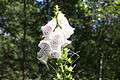
Red thimble, white variant

Sphagnum magellanicum

Rosemary heather
Crowberry

Common cranberry

Bogberry


In the center lies the raised bog, home to peat mosses such as the magellan peat moss (Sphagnum magellanicum) with its reddish color and strikingly large leaves and the spit peat moss (Sphagnum cuspidatum) with its greenish color, which thrive on strongly acidic, nutrient-poor and water-saturated soil . This area receives only nutrient-poor rainwater and no nutrient-enriched groundwater. Occasionally poorly trained pines grow there. The round-leaved sundew and butterwort grow here , both are insect-catching plants , as well as rosemary heather , bell heather and gray heather . Other plants, some of which are rare, grow in the Black Moor, such as the seven-star , marsh fern , peat turf and ostrich-flowered loosestrife . Of the 30 types of peat moss that exist in Central Europe, eleven occur in the Black Moor, seven of which are predominantly in the raised bog area and the rest in the fen area.
Wildlife
The black moor is relatively poor in animal species. Vertebrate species living there are also usually very shy and avoid being near visitors. To the counterparties located in Moor mammal species counts pine marten , the secretive marsh shrew and the Iltis . In addition, there are the predators typical of the Rhön, such as the ermine , which is sometimes active during the day , the weasel and the fox , which is more numerous due to its rabies immunization . The stone marten , the badger and the raccoon that immigrated to the Rhön in 1970 are active in the dark. These nocturnal animals can be indirectly detected by means of traces, feeding remains and solution . Roe deer can be found in the region all year round . Other animals that can be found there are brown hares , squirrels and dormice .
Black grouse , which are threatened with extinction outside the Alps , have one of their last retreats in the Black Moor and in the entire Hochrhön . The numbers have been at a low level for years, in recent years specimens from Sweden have been released into the wild several times. There are also common snipe , dwarf snipe , Common bins Virgin , Tree Pipit , Meadow Pipit , grasshopper warblers and occasionally the capercaillie . In the spruce forests on the edge of the moor, the crossbill , the rough-owl and the jay can be found . As an occasional guest you can meet the corn corn , which is rare and endangered in Europe . The adder , fire salamander , blindworm and mountain lizard live in the drier areas of the moor . This often occurs in a dark-colored variant called the bog lizard. The most common birds of prey are the kestrel , red kite, and buzzard . The woodcock , which is common in the Hochrhön, can also be seen in the Black Moor.
The larvae of the bog dragonflies are dependent on bog pools. In the central moorland, the arctic emerald dragonfly , the peat damsel , the swamp darter, and the large and small moss damsel find sufficient living conditions. Moor dragonflies are sensitive to the smallest changes in the living environment. The extinction of the very rare high moor mosaic maiden in the Black Moor is probably due to the changing water quality of the moor eyes since the 1970s. Other common dragonfly species have instead increased.
- Wildlife in the Black Moor

Great Moss Maiden
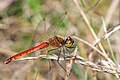
Swamp darter

Black grouse

Adder

High-moor mother-of-pearl butterfly

Small peacock butterfly (caterpillar) on bogberry


Amphibians such as the mountain and pond newt , the common frog and the common toad live in the flarks and pools . There are no fish and higher aquatic plants because of the nutrient-poor and acidic water in the bog eyes. The temperatures of the water are also very low into the height of summer. Only plankton communities with diatoms , ornamental algae and microorganisms settle there . Ten different species of locusts have been identified in the Black Moor. The caterpillars of the bog-specific butterflies such as the raised bog yellowblings , the raised bog mother-of-pearl butterflies and the ducat butterflies find their forage plants in the bogus and cranberries . There is also an endemic raven-winged species in the bog .
Peat extraction

From 1770 to 1939 peat was quarried irregularly in the Black Moor, but it only produced small quantities. Humans intervened in the water balance of the bog by digging ditches for drainage at various points. In these areas, the water level in the bog fell and the peat moss stopped growing or died. Among other things, the Würzburg court chamber tried to dig peat in the black moor, but it was not worth it. In 1802 stone pavement was found in the moor, which does not indicate a village that was presumed there for a long time, but rather the peat cut of the court chamber around 1770. The sunken village that was supposed to be in the Black Moor and which is said to go back to the year 827 arranges in the meantime the Köhlersmoor near Hünfeld . In the Red Moor, however, more peat was extracted. In 1905, bath peat was once again delivered for a short time from the Schwarzen Moor to Bad Kissingen . However, this failed because the quality was criticized, unpaved dirt roads made it difficult to remove and the drainage costs were too high.
The central plateau was described as almost tree-free until around 1924. After that, the pine spread, probably aided by the drainage work of the Reich Labor Service during the Third Reich . The area was placed under nature protection on January 6, 1939 . After that no peat was allowed to be extracted. In the 1960s and early 1970s, the as yet undeveloped moor was increasingly used by day trippers. Several trails were formed in the bog. This led to the systematic destruction of large parts of the bog, mainly on weekends and during the holiday periods. The bank areas of some bog eyes were trampled on, the plant cover there partially destroyed and animals scared away. Some visitors even bathed in the bog eyes and there was a diving board there.
Moor nature trail


As a protective measure to maintain the nature reserve, the maintenance team of the nature park surrounded the black moor in 1976 with a two meter high and 4.8 kilometer long fence. This work was carried out in close working and funding group with the government of Lower Franconia, the Würzburg Land Consolidation Directorate and the Forestry Directorate. In order to allow the population to continue to have access to the moor, a first paved path was built within the protected area in 1976. In the early 1980s, a 1.8 kilometer long stick dam was built, which led to the most interesting areas of the moor. The protective measures have had a positive effect on the regeneration of the moor. However, some animals and plants disappeared before the protective measures were implemented. Among them was the flowering rush , which had previously grown over a large area in the moor and was last seen in 1960.
In the period that followed, the footbridge was damaged by weathering and heavy loads, so that an immediate replacement was necessary for safety reasons. In order to protect the black grouse , which is threatened with extinction , the Lange Rhön, in which the Black Moor is located, was designated as a nature reserve on May 28, 1982 with its current area of 3245 hectares. When planning the new footbridge, which was to run through the moor with a new route, the endangered costs in the moor were taken into account. In May 1987 the new moor path was opened as the first moor nature trail in Bavaria with a 2.2 kilometer long oak boardwalk. Along the footbridge, 22 information boards present the flora and fauna of the moor. Silting up bodies of water have mutated into swinging lawns ; re-irrigation measures have been underway since 2000. For this purpose, former drainage ditches were closed by small weirs to keep the water in the bog.
In 2001, as a joint initiative of the government of Lower Franconia, the Bavarian Administration of the Rhön Biosphere Reserve and the Rhön Nature Park, the information boards on the nature trail were redesigned as part of the implementation of the transnational EU project LIFE and their number increased to 23. The biologist Ursula Schneider was responsible for the coordination and overall technical management. The moor nature trail has been expanded in recent years. In the last part of the circular route, another boardwalk branches off the nature trail and leads directly to the entrance and exit of the moor. In 2007, a 17-meter-high observation tower with a 56-square-meter roofed observation platform was built on the northern edge of the moor next to the boardwalk for 225,000 euros . The tower is located near the branching off extended section and can also be reached directly from the entrance of the Black Moor.
The first section of the nature trail is walked twice - as a way there and back - and the rest of the way as a circular path. The entire route is 2.7 kilometers and leads past the various areas of the moor. The entrance to the moor is in the north and from there initially leads south past the edge of a Carpathian birch forest. The path continues to the fen, which stretches as a swamp belt around the intact raised bog. The nature trail runs in a large curve and then leads north to the central plateau. It leads past a bog eye, Flarken and Schlenken. From this area of the path, the entire central plateau can be seen. The path continues from the central area through the low moor, then to the observation tower and from there back to the exit with two different path variants. The path from the central moor to the tower leads past a water hole, a former small silted peat dig.

In April 2011, the trail after appropriate redesign was specifically for the target group of children as the fourth of its kind in Germany by ZDF telecast dandelion and the Association of German Nature Parks honored as dandelion path. Such paths are intended to give children an incentive and the opportunity to experience nature and to try it out independently and actively.
Geotope
The Black Moor is listed as a geotope in the Environmental Object Catalog (UOK) Bavaria with the predicate valuable . In Bavaria, the State Geological Office (now: Bavarian State Office for the Environment ) describes around 2800 geotopes in detail. From these, a committee of experts from the highest specialist authority for geology, nature, water and the environment has been selecting the 100 geotopes that are considered to be the most important since 2001. The Black Moor was chosen by this committee on July 20, 2007 as the 56th object from Bavaria's most beautiful geotopes . The black moor is designated as a peat community with geotope number 47 and geotope 673R008. See also the list of geotopes in the Rhön-Grabfeld district .
tourism


The Black Moor is well developed for tourism and a popular destination in the Rhön. Every year 100,000 to 150,000 people visit the freely accessible, wheelchair-accessible Black Moor; it ranks second behind the Kreuzberg in the Bavarian Rhön. From May to October, guided hikes through the moor are offered several times a week. 300 meters north-east of the Black Moor, on the road to Seiferts , there is a large parking lot and the Haus zum Schwarzen Moor , newly built in 2005 , with sanitary facilities, kiosk and snack area and the information center. The environmental education station of the Bavarian Rhön Biosphere Reserve , which opened in 2005, is located on the eastern edge of the Black Moor , with a training room for school classes and a covered outdoor work area.
The Hochrhöner long-distance hiking trail and various extra tours such as the museum trail lead past the moor.
Reich Labor Service Camp


The former Reich Labor Service (RAD) camp Hochrhön, also known as Dr. Hellmuth camp, was located on the eastern edge of the Black Moor. The stone gate built in 1936 in the entrance area still serves as a memorial today. The camp was built between August 1934 and spring 1936 and housed around 300 people. Mainfrankens Gauleiter Dr. Otto Hellmuth wanted to cultivate the economically weak region with his "Rhön construction plan" and open it up for agriculture (the so-called Dr Hellmuth plan for the reorganization of the Main Franconia Gau ). The Rhön was defined as an area of emergency that was to become an area of prosperity. The tasks of the RAD were: laying drains, removing stones, planting spruce and growing potatoes . The measures did not produce the desired result. In 1945 the camp was abandoned and removed except for the foundations, which can still be seen. The Rhönhof ( Ludwig-Siebert -Hof) was completed as a model farm by the RAD men by 1938 . During this time around 500 hectares of young forest were afforested. The afforestation around the Black Moor stems from these measures.
Myths and legends
There are various sagas and legends about the Black Moor that have survived to the present day:
The sunken village in the black moor
“Time immemorial, a beautiful city or, as others would like to know, a large village sank in the Black Moor because the inhabitants did not want to give up their sinful life. The town or village was now replaced by an unfathomably deep, black lake, which was gradually covered, apart from the few black holes, by a thick blanket of bog. In the depths of the moor, however, life has not yet died; because when the inhabitants of the sunken place rush to their church and repentantly pray there for redemption, then it roars violently in the bog and black, muddy water ferments from the so-called 'ponds'. Also, some who lay down on the edge of the moor sometimes still chime the tower clock and heard the cocks crow from below. Only three virgins from the sunken place were allowed to come up from the bog at times. They were called the moor maids in the area and regularly came to the fair dance in Wüstensachsen. But when they were held back there over time, they sadly left the dance floor. The next morning one of the ponds was colored blood red. Since then nobody has seen the Moorjungfern in the desert. In the nocturnal hour only the souls of the three moor maids with those of the others who have sunk there float as false lights over the moor. "
The Rhönmoore
“It is said about the formation of the Rhön moors that the devil led water veins from the sea through the underground rocky fissures into the Rhön Mountains, which turned the plateaus of the Rhön into moors. Originally the devil intended to use the drained and dammed water to flood the valleys. But in their need the residents prayed to God to avert the impending danger; and when the devil had to see that all his labor was in vain, he angrily abandoned the work he had begun to do, and so the moors remained. His clan, which he had now settled on the Hohe Rhön, sank in the Red Moor. "
Sea birds
Another story about the moor is about the sea bird. It is said that in the Black Moor, on mild summer nights, a bird sometimes sings, a strange song that disappears every time the avebell rings out from the depths of the swamp at dawn.
Prayer against inundation
Until around 1780, a prayer hour had been held every Friday in the community of Rüdenschektiven to avert the feared flooding of the village and the destruction of the corridors. The community feared that the moor would rustle and rage on a stormy night, only to break out and flood the whole area.
The moor as a weather prophet
The Black Moor serves as a weather prophet for the surrounding villages : If there is a light mist on the moor in the morning, there is no nice day. Cloudy, rainy weather is prophesied in the morning by thick haze. If the moor smokes in the morning, storms and thunderstorms can be expected. The worst storm can be expected when a storm sweeps over the moor early in the morning and the moor's eyes hit high waves. The roar of the moor water could even indicate earthquakes taking place far away.
literature
- Nature Park and Biosphere Reserve Bayerische Rhön e. V. (Ed.): Black Moor Nature Trail. 2003.
- Zweckverband Naturpark Bayerische Rhön (Ed.): Black Moor nature trail. Rötter Druck und Verlag GmbH, Bad Neustadt, 1988.
- Willy Kiefer : The Moors of the Rhön. Verlag Parzeller GmbH & Co. KG, Fulda 1996, ISBN 3-7900-0269-0 .
- Joachim S. Hohmann : Country folk under the swastika. Agricultural and race policy in the Rhön. A contribution to the regional history of Bavaria, Hesse and Thuringia. Frankfurt / M., Berlin, Bern, New York, Paris, Vienna 1992, ISBN 978-3-631-45093-2 .
- Max Mölter: The Hochrhönstrasse. Verlag Parzeller Fulda, 5th edition 1986, ISBN 3-7900-0149-X .
- Heribert Kramm: The Hochrhön. Verlag Parzeller GmbH & Co. KG, Fulda 2006, ISBN 3-7900-0305-0 .
- Theodor Gies: Vegetation and ecology of the Black Moor (Rhön) with special consideration of the cation content. Dissertationes Botanicae, 1972; ISBN 978-3-7682-0857-4 .
- Udo Bohn: The vegetation of the Hohe Rhön - society inventory, assessment, current threats, conservation measures. Nature and landscape. Bonn-Bad Godesberg 1981.
- Gisbert Große-Brauckmann : Moors in the Rhön as examples for the origin, development and formation of moors and their problems today. Contribution to natural history in East Hesse. Fulda 1996.
- LIFE project Rhön of the EU (Ed.): Natural treasures of the Rhön: Hochmoore. Kaltensundheim 1997.
- Jürgen Holzhausen, Ernst Hettche: Raised moors in the Rhön Biosphere Reserve. Richard Mack Verlag, Mellrichstadt 1996, ISBN 3-9802436-2-1 .
Web links
- Black moor . In: Biosphaerenreservat-Rhoen.de
- Schwarzes Moor - Geotope number 47 . In: lfu.bayern.de (Bavarian State Office for the Environment)
- Schwarzes Moor information point
- Black moor . In: Rhoenline.de
- Photos from the Black Moor . In: Rhoenpixel.de
- Schwarzes Moor observation tower. In: Structurae
Individual evidence
- ↑ Willy Kiefer: The Moore der Rhön. Page 10.
- ↑ Natural treasures of the Rhön: high moors. Page 7.
- ↑ Nature Park and Biosphere Reserve Bayerische Rhön e. V. (Ed.): Black Moor Nature Trail. Pages 28–29.
- ↑ a b Horst Bayer: The current climate development of the Rhön with compare to the Thuringian Forest.
- ↑ Nature Park and Biosphere Reserve Bayerische Rhön e. V. (Ed.): Black Moor Nature Trail. Pages 38–39.
- ↑ Nature Park and Biosphere Reserve Bayerische Rhön e. V. (Ed.): Black Moor Nature Trail. Pages 34–35.
- ↑ The black grouse in the Rhön. Rhön Nature and Habitat Association, accessed on February 28, 2016 .
- ↑ Natural treasures of the Rhön: high moors. Page 12.
- ↑ a b c Max Mölter: The Hochrhönstrasse. Page 38.
- ↑ a b Willy Kiefer: The moors of the Rhön. Page 12.
- ↑ Black Moor nature trail. Page 33.
- ↑ rhoentourist.de
- ↑ Moor nature trail on the Black Moor now the official dandelion path . Fuldaer Nachrichten, May 23, 2011, accessed on July 18, 2011 .
- ↑ Dandelion path for children on the Black Moor. main.de (Mainpost), April 28, 2011, accessed on July 18, 2011 .
- ↑ Moor nature trail on the Black Moor now the official dandelion path . Fuldaer Nachrichten, May 23, 2011, accessed on July 18, 2011 .
- ↑ Environmental objects catalog Bavaria - Black Moor
- ↑ Geotope research at the Bavarian State Office for the Environment
- ↑ Bavaria's most beautiful geotopes at the Bavarian State Office for the Environment
- ↑ Press release from July 20, 2007
- ↑ Schwarzes Moor - Number 47
- ↑ Geotope: Schwarzes Moor (accessed on September 26, 2013; PDF; 268 kB)
- ↑ Schwarzes Moor environmental education facility ( page no longer available , search in web archives ) Info: The link was automatically marked as defective. Please check the link according to the instructions and then remove this notice.
- ↑ Tourist-Information Fladungen Rhön ( Memento of the original from January 18, 2008 in the Internet Archive ) Info: The archive link was inserted automatically and has not yet been checked. Please check the original and archive link according to the instructions and then remove this notice.
- ^ Ludwig-Siebert-Hof or Rhönhof bei Hausen
- ↑ Willy Kiefer: The Moore der Rhön. Pages 21–22.
- ↑ Heribert Kramm: The Hochrhön. Page 24.
- ^ Max Mölter: The Hochrhönstrasse. Page 36.