
Uila
|
Uila Weilau Vajola |
|||||
|
|||||
| Basic data | |||||
|---|---|---|---|---|---|
| State : |
|
||||
| Historical region : | Transylvania | ||||
| Circle : | Mureș | ||||
| Municipality : | Batos | ||||
| Coordinates : | 46 ° 56 ' N , 24 ° 37' E | ||||
| Time zone : | EET ( UTC +2) | ||||
| Height : | 521 m | ||||
| Residents : | 602 (2002) | ||||
| Postal code : | 547088 | ||||
| Telephone code : | (+40) 02 65 | ||||
| License plate : | MS | ||||
| Structure and administration | |||||
| Community type : | Village | ||||


Uila (outdated Voila ; German Weilau also Wela , Hungarian Vajola ) is a village in the Mureş district in the Transylvania region in Romania . It is part of the municipality of Batoş .
Geographical location

Uila (Vájola) , or
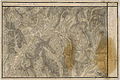
Uila (Wayola) , in the Josephine land survey from 1769 to 1773.


The village is located in the north of the Transylvanian plateau in the so-called Reener Ländchen . On the stream of the same name, on the northern border of the Mureș district where the Bistrița-Năsăud district begins and the village road (Drum comunal) DC 162, the place is located seven kilometers north of the community center and about 22 kilometers northwest of Reghin (Saxon rain) . In the north lie the municipalities Șieuț (Kleinschogen) , Posmuș (Passbusch) and Pinticu (Pintac) , in the west Teaca (Tekendorf) and Logig (Ludwigsdorf) , in the south Batoș (the community center) and in the east Monor (Mindorf) .
The highest mountain on the Weilauer Hattert, called Flachsberg or Feßberich , has a height of about 700 m. The three streets Niddergaß , Ewerschtgaß and Ruedschgaß form the village, which is located in a narrow basin and is surrounded on almost all sides by forests, orchards and vineyards (see: Viticulture in Romania ). The valley is only open to the south, here the only connection road runs to the outside of the administrative community.
Place name
According to a monograph of the community by Hannes Frim, the name Weilau comes from the Middle High German words "Well" and "Au". That is the dialect form "Wella". The name "Wella" refers to a round meadow or forest clearing in a remote forest valley, where fighting games took place and sacrifices were made for cultic purposes. This interpretation is quite plausible when one takes into account that the village of Weilau is quite isolated.
history
Human life has been traceable for a long time in the area of the village of Weilau. For example, when a new vineyard was planted, a stone hoe was found about two meters deep, which Hannes Frim described in great detail in his monograph “Aufstieg und Niedergang”. He also mentions a bronze ax and other jewelry-like stone structures that were pierced like pearls, as well as a burial urn with additions. The objects mentioned were not assigned to any era and are currently in the Brukenthal Museum in Sibiu .
It is not known exactly when the first German settlers ( Transylvanian Saxons ) came to Weilau - it is very likely at the beginning of the 13th century. The municipality was first mentioned in a document in 1228 as villa Radus (still included in the field name Ruadesch / Ruedsch today). The second mention was made in 1319 as possesio Veyla , probably a later settlement after the fall of Radus-Ruadesch by the Mongol storm of 1241/42. It can be assumed that Weilau was already inhabited by German settlers during the great Mongol and Tatar storms (1241). Oral tradition reports that at that time the inhabitants fled to the Călimani Mountains (Kelemen Mountains) and lived at the foot of the Poiana Tomii . The place is called "At the Weilauer Ovens" (La sobele uilenilor) to this day .
In the course of its history, Weilau has been ravaged by devastating fires several times, with the village partially and once completely burned down. The last great conflagration destroyed the Ruedschgaß in 1892 . The fire was caused by children playing. During an earlier fire disaster at the beginning of the 18th century, the parsonage also fell victim to the flames. With the rectory, all written records and books are burned. It is due to this fact that there are no written records of Weilau's distant past. In the more than 800 years in which Weilau was mainly inhabited by the Transylvanian-Saxon population, there was an economic ups and downs, as in other parts of the world. The main occupation of the inhabitants until the turn of the century consisted in viticulture, agriculture and cattle breeding (especially ox fattening and sheep breeding). The oldest community seal with the inscription "GEMEINDE WEHLA" with two song thrushes sitting on a vine is evidence of this.
A serious economic turning point was the destruction of the vineyards by phylloxera after 1900, which had a negative impact on the economic situation, so that some residents of Weilau settled in the USA and Canada , where they founded their own farms. The First World War also cost the community victims, as attested by a white marble plaque in the church choir.
The Second Vienna Arbitration Award resulted in a division for Transylvania for the first time since Germans lived there. Central and southern Transylvania was Romanian territory, while Northern Transylvania with the Szeklerzipfel , who until a few kilometers from Brasov (Kronstadt) , handed Hungary was awarded. In Weilau, which belongs to northern Transylvania, there was a special development between 1940–1944, which then led to the flight of the German population on September 12, 1944. At the time of the evacuation in autumn 1944, about 640 Transylvanian Saxons, two Romanian families, about 150 Gypsies ( Protestant creed) and one Jewish family lived in Weilau (until their internment in spring 1944).
Due to the advancing front in autumn 1944, the German Wehrmacht gave the order to withdraw on September 11th. The move had to begin the following morning. The horse-drawn car columns reached Lower Austria on October 22, 1944, in the vicinity of the town of Hainfeld , in the Lilienfeld district, where the second car column with the slower horned cattle teams arrived two weeks later. When in the spring of 1945 the front again approached threateningly close, around half of the people of Weilau decided to continue in the direction of Upper Austria . The other half stayed in Lower Austria . After a three-week march, this second trek came to the vicinity of Vöcklabruck , where many people from Weilau on the Attersee and its near and far surroundings (Rosenau, Timelkam and the Salzburg area) settled.
After the Red Army marched into Austria in the spring of 1945, those who remained in Lower Austria came to the Soviet occupation zone and, at the request of the Russians, had to return to their old homeland, to Weilau. That was about a third of the original German population before the war, about 270 people. The returnees felt the same way in Weilau as in many other northern Transylvanian communities: The houses were occupied by colonists, the Transylvanian Saxons were expropriated and put in labor camps. Some were intercepted at the Romanian border in Oradea (Greater Oradea ) and taken to the Soviet Union for forced labor .
Many Germans from Weilau, like in the other communities in northern Transylvania, decided to emigrate to Germany in the 1970s. Today the evangelical community, which still exists, is supported by the resident gypsies, who also use the church and call themselves "evangelical gypsies".
population
The population of today's Uila municipality developed as follows:
| census | Ethnic composition | ||||
|---|---|---|---|---|---|
| year | population | Romanians | Hungary | German | other |
| 1850 | 890 | - | - | 854 | 63 |
| 1900 | 926 | 50 | 8th | 868 | - |
| 1941 | 869 | 50 | 3 | 677 | 139 |
| 1977 | 746 | 190 | 194 | 238 | 124 |
| 2002 | 602 | 215 | 175 | 12 | 200 |
Since 1850, the highest number of inhabitants in Uila and that of Romanian Germans in 1900. The highest number of Roma (179) and that of Romania was registered in 2002 and that of Magyars (214) in 1966.
source
Web links
Individual evidence
- ^ Institute Of Archeology - Uila , accessed September 26, 2019 (Romanian).
- ↑ Michael Weber: “Mir sen Lutheraner!” Lutheran Service, 1996, accessed on September 26, 2019 .
- ↑ Censuses 1850–2002, last updated November 2, 2008 (PDF; 1 MB; Hungarian).