Kassala
| كسلا Kassala |
||
|---|---|---|
|
|
||
| Coordinates | 15 ° 28 ' N , 36 ° 23' E | |
| Basic data | ||
| Country | Sudan | |
| Kassala | ||
| ISO 3166-2 | SD-KA | |
| Residents | 510,165 (2012) | |
Kassala ( Arabic كسلا, DMG Kassalā ) is the capital of the Sudanese state of Kassala of the same name .
location
The city is located in the east of Sudan, around 400 kilometers from Khartoum , near the border with Eritrea on the eastern bank of the Gasch River at 495 meters at the foot of the 1390 meter high Taka Mountains.
history
The fertile plain in the west of the Taka Mountains had long been inhabited by Hallenga, an ethnic group of the Bedscha who are said to have come from the Arabian Peninsula . Around 1820 came Muhammad Uthman al-Mirghani, who by his Sufi -Lehrmeister and the Order founder of Mecca was sent out on a mission trip through Egypt to the Nile , then the Atbara upriver to remote in this area. Here he decided to found a settlement, to which he named al-Saniyya ("the exalted"), and to spread his own Sufi teachings on the renewal of Islam. This later became the center of the Khatmiyya brotherhood. He himself returned to Mecca in 1821 and left the development of this place to the headquarters of the new brotherhood to his son and successor Al-Hasan al-Mirghani, who arrived around 1840 at about the same time as the troops of the future Turkish-Egyptian rulers over Sudan. Al-Hasan built an exemplary settlement at the foot of the mountains, which also attracted believers from far away from the region on the Red Sea and was named al-Khatmiyya . About five kilometers away, the Turkish-Egyptian soldiers set up a garrison that was supposed to control a similar area and was held by 4,000 men. They had not achieved their goal of completely subjugating the Bedjah clans. The city of Kassala developed around the military station.
Economic and power-political reasons led to a successful cooperation between the supporters of the Khatmiyya and the occupiers. Al-Hasan gained further popularity, recognition and the reputation of a miracle worker on missionary trips in the country. The holy spring in the mountains not far behind his grave, which is still valued today as beneficial to health, is said to have personally struck him with a stick in the rock. Both became a pilgrimage destination after his death in 1869.
The Mahdi uprising (1881–1899) was the first organized opposition to the Turkish-Egyptian occupation and a conservative Islamic uprising against the veneration of saints as practiced by the Khatmiyya. With the support of the allied Majdhubiya order of ad-Damir , Mahdist Hadendoa conquered the garrison, which had been besieged for two years, in 1885 and destroyed the Khatmiyya mosque and the mausoleum for al-Hasan, which had recently been built. In 1894 Kassala was conquered by Italian troops from Eritrea, but handed over to the Egyptians in accordance with the treaty in 1897. In 1899 the English took Kassala as well as the Mahdist power center, Omdurman . The Anglo-Egyptian administration began. One year before the end of Italian colonial rule in Eritrea, Mussolini's troops occupied Kassala in 1940, and as a token of goodwill they began restoration work on the mausoleum and the mosque.
Apart from the influence exercised by the political arm of the Khatmiyya Brotherhood, the Democratic Unionist Party (DUP), since the country's independence in 1956 , Kassala also became a center for the opposing Mahdists who have organized themselves politically in the Umma Party. Despite its location near the border with Eritrea, with which Sudan has a tense relationship, Kassala was relatively little affected by unrest and war until the expansion of the South Sudanese civil war into the east of Sudan around 1997. It was not until 2000 that violent fighting broke out in Kassala between the Arab-dominated government army and the South Sudanese SPLA, which is allied with the internal Arab opposition ( National Democratic Alliance, NDA) . These had allied themselves to the Eastern Front , which was joined by the Beja Congress . In 2006, the conflict in East Sudan came to a temporary end through an agreement between the government and the local rebel groups .
population
For Kassala 510,165 inhabitants (2012 calculation) are given.
Population development
| year | Residents |
|---|---|
| 1956 (n / a) | 40,600 |
| 1973 (census) | 99,652 |
| 1983 (census) | 142.909 |
| 1993 (census) | 234,622 |
| 2012 (calculation) | 510.165 |
ethnicities
Kassala is the third largest city in Sudan outside of the greater Khartoum area, with a large number of different ethnic groups . The Hadendoa , Beni Amer and Halanga belong to the long -established ethnic groups of the Bedscha . The women of the Rashaida nomads who settle in the area, recognizable by their black robes (deaf) , sell household goods and handicrafts in the market center in the mornings. A large part of the wider mixed population of Kassala was attracted by the religious movement of the Khatmiyya or by the military station in the 19th century and remained as agricultural workers in the irrigated fields along the Gash. With the Egyptian occupation came Jaibiyyin, who at the time played an economic and political leadership role, and Shaygiyya from Northern Sudan. In addition, emigrants from the neighboring countries of Yemen , Eritrea, Ethiopia and Somalia joined in the 20th century , as did some Indians, who are mostly traders in the market. During the war of liberation against the Derg regime, thousands of Ethiopian refugees settled in spacious provisional settlements on the outskirts of the city from the late 1970s. In the mid-1980s, black African refugees fled the famine in South Sudan to Kassala.
Kassala has a high percentage of the population from West Africa. Kanuri from the region around Lake Chad and Fulbe were among the first settlers in the city . Some West Africans, who are often summarized in statistics as “Nigerians”, also got stuck on the pilgrimage to Mecca in Kassala and are called “Takarir”, others were hired out in the army of Madhi with which they were sent to Kassala, and later to settle in the war depopulated area. In the 1993 census, around 23 percent Nigerians were given for the city of Kassala.
Cityscape
The new center of the city (Al-Mowgif al-Aam) with a busy market district is about two kilometers east of the broad, dry river bed of the Gash between October and June . The intercity bus station in the Souq as-Shaabi district is five kilometers to the east on the thoroughfare . In between, a wide strip of arable land ( Sawagi: "gardens") divides the urban areas along the river . The former British district of Sikka Hadiid around the disused train station is located directly on the east bank of the Gash. A wholesale market for agricultural products (Souq Gharb al-Gash) is held there every day . To the north and south, residential areas each extend over several kilometers.
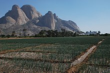
The round granite domes called Taka, Totil or simply Kassala mountains can be seen from afar and are symbols of the city. The rock massif rising individually from the plain in the north is called Mukram, the mountain range in the south near the district of Khatmiyya has the peaks Taka, Totil and Aweitla from north to south.
economy
A flat sandy desert begins on the (eastern) rear of the mountains towards Eritrea, to the north is the Nubian desert . Nevertheless, a large area around Kassala is one of the most fertile regions in Sudan. In the 19th century, the agricultural yield, which was dependent on the annual flooding caused by the gas flood, could be increased through irrigation canals and diesel pumps that draw groundwater from wells. An average of 300 millimeters of annual precipitation falls for rain-fed agriculture in the months of July and August. The amount of rain is sufficient for a one-year vegetation cover in the district of Kassala, which is used by nomads as pastureland.
In the summer months, the flooding of the gas is channeled into irrigation channels and used for cultivation. In many fields, irrigation makes it possible to harvest even in the winter dry season. Especially in the dry season, the green fields look like an oasis. There are sorghum , sesame grown fruits and vegetables, most notably oranges, bananas and onions. In the direction of Gedaref , cotton is grown on large areas .
One problem is the flooding caused by the Gash River, which has often flooded entire areas, including the city. After heavy rains in the Eritrean inflow area, a spring tide can be expected in Kassala about three days later. Precautionary measures fail because of the hostility of both countries. Flood disasters occur roughly every five years; the last were in 2003 and 2007.
Infrastructure

In the 1920s, the railway line from Port Sudan via Kassala (1924) and Gedaref (1929) to the connection to the line leading south from Khartoum at Sennar was continued to transport cotton and grain to the port. Train traffic was maintained until at least the early 1980s, after which it was completely stopped. The road connections to Khartoum and Port Sudan are paved and in good condition. A road 80 kilometers long connects Kassala with the New Halfa irrigation project . The nearby border crossing to Eritrea is mostly closed. Kassala Airport is located in the south-west of the city on the road to Khartoum . There are no regular domestic flights.
sons and daughters of the town
- Hasan at-Turabi (* around 1932; † 2016), politician and religious leader in Sudan
- Abdelaziz Baraka Sakin (born 1963), writer
Climate table
| Kassala | ||||||||||||||||||||||||||||||||||||||||||||||||
|---|---|---|---|---|---|---|---|---|---|---|---|---|---|---|---|---|---|---|---|---|---|---|---|---|---|---|---|---|---|---|---|---|---|---|---|---|---|---|---|---|---|---|---|---|---|---|---|---|
| Climate diagram | ||||||||||||||||||||||||||||||||||||||||||||||||
| ||||||||||||||||||||||||||||||||||||||||||||||||
|
Average monthly temperatures and rainfall for Kassala
Source: Sudan Meteorological Authority, data: 1971–2000; wetterkontor.de
|
|||||||||||||||||||||||||||||||||||||||||||||||||||||||||||||||||||||||||||||||||||||||||||||||||||||||||||||||||||||||||||||||||||||||||||||||||||||||||||||||||||||
Web links
Individual evidence
- ↑ Archived copy ( Memento of the original dated December 29, 2011 in the Internet Archive ) Info: The archive link was automatically inserted and not yet checked. Please check the original and archive link according to the instructions and then remove this notice. World Gazetteer
- ↑ Catherine Miller and AA Abu-Manga: The West African (Fallata) Communities in Gedaref State. Process of settlement and local integration. In: Catherine Miller (Ed.): Land, ethnicity and political legitimacy in Eastern Sudan. Cairo 2005. Online, pp. 3, 5, 29 (PDF; 346 kB)
- ^ Floods threaten food supplies in Sudan's east-FAO. Sudan Tribune, August 25, 2007
- ^ Sudan Meteorological Authority: Klimainformationen Kassala. World Meteorological Organization, accessed October 27, 2012 .


