Mareb
|
Mareb Gash or al-Qash ( Arabic القاش) |
||
|
The Mareb in the Atbara river system |
||
| Data | ||
| location |
|
|
| River system | Nile | |
| Drain over | Atbara → Nile → Mediterranean | |
| origin | Near Barda 15 ° 14 ′ 0 ″ N , 38 ° 50 ′ 0 ″ E |
|
| Infiltration | in Sudan coordinates: 16 ° 4 ′ 0 ″ N , 36 ° 16 ′ 0 ″ E 16 ° 4 ′ 0 ″ N , 36 ° 16 ′ 0 ″ E
|
|
| length | 440 km | |
| Catchment area | 31,000 km² | |
| Discharge at the Kassala gauge |
MNQ 1907-2003 MQ 1907-2003 MHQ 1907-2003 |
0 l / s 21.6 m³ / s 870 m³ / s |
| Left tributaries | Sarana, Balasa, 'Engweya, Gala Shet' | |
| Right tributaries | Obel | |
|
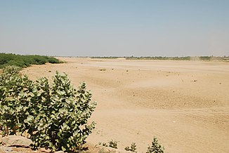
Dry river bed of the Gash near Kassala |
||
The Mareb (so the European spelling, actually Märäb ; in the lowlands Gash or in Arabic al-Qash (القاش) is the northernmost of the northwest flowing rivers in the highlands of Abyssinia . He is seasonal and forms part of the border of Ethiopia to Eritrea .
geography
According to the Statistical Abstract of Ethiopia for 1967/68 , the Mareb is 440 kilometers long. It rises about 15 km southwest of Asmara . It initially runs south to the Ethiopian border. Then to the northwest until it reaches the Sudanese plain near Kassala . In the Eritrean lowlands, the river Gash (after the Sudanese border al-Qash) is called and gives the administrative region Gash-Barka its name. Most of the year the Mareb is dry, but like the Tekeze-Setit , it can suddenly swell during the rainy season. In contrast to the other large rivers on this side of the Ethiopian highlands, the Mareb only flows into the Atbara and thus into the Nile during extreme floods . Usually it seeps into the sand of the Sudanese plain. The information on the catchment area is very contradictory and lies between 21,000 and 44,000 km².
Only the left bank of the upper reaches lies in Ethiopian territory. The main tributaries are the Obel on the right bank and the Sarana, Balasa and 'Engweya on the left.
history
Historically, the Mareb is interesting as the border between the areas of two Ethiopian nobles at the time of the Middle Ages: the bier negasch or Bahri negassi , short form Bahrgassi ( Tigrinya "king of the sea", ie the part of the Abyssinian highlands closest to the sea) north of the River and the Makonnen of Tigray to the south. The territory of the bier negash extended to the coast of the Red Sea in the north, its capital was usually Debarwa in what is now Eritrea, about 20 miles south of Asmara.
See also
Individual evidence
- ↑ "Science in Africa" (PDF; 1.8 MB) UNESCO
- ↑ ENVIRONMENTAL IMPACT ASSESSMENT KASSALA ( Memento of the original from October 2, 2013 in the Internet Archive ) Info: The archive link was inserted automatically and has not yet been checked. Please check the original and archive link according to the instructions and then remove this notice. (PDF; 3.1 MB)
- ↑ Guleid Artan et al .: Adequacy of satellite derived rainfall data for stream flow modeling (PDF; 850 kB)

