
Omdurman
|
أم درمان Umm Durmān Omdurman |
|||
|---|---|---|---|
|
|||
| Coordinates | 15 ° 39 ′ N , 32 ° 29 ′ E | ||
| Basic data | |||
| Country | Sudan | ||
| al-Chartum | |||
| District | al-Chartum | ||
| ISO 3166-2 | SD-KH | ||
| height | 388 m | ||
| Residents | 2,395,159 (2008) | ||
| Metropolitan area | 8,363,915 (2007) | ||
 The tomb of Mahdi Muhammad Ahmad
|
|||


Omdurman ( Arabic أم درمان Umm Durmān ; Alternative spelling Umm Durman ) is a city in the Sudanese state of al-Chartum and the largest city in the country.
With the capital Khartoum and the city of al-Chartum Bahri , it forms a tri-city connected by several bridges , separated by the Nile , which flows together here. In contrast to the economically prosperous business district of Khartoum, Omdurman has mostly residential areas.
The city has had its own tradition since it was founded by the Mahdi Muhammad Ahmad . It acts as the country's religious center. Among other things, it houses the Islamic University of Omdurman , and various Sufi brotherhoods ( tariqas ) are active here.
location
The Tricity is grouped around the confluence of the Blue and White Nile , with Omdurman on the western left bank of the White and the United Nile. Chartum and al-Chartum Bahri are located east of the White and United Nile respectively: Chartum south and Bahri north of the Blue Nile. To the north of the confluence, the desert spreads, to the south, between the Blue and White Nile, the fertile Jazira plain .
population
Omdurman is the largest city in Sudan with 2,805,396 inhabitants (2012 calculation).
Population development:
| year | Residents |
|---|---|
| around 1890 (n / a) | 150,000 |
| 1909 (census) | 42,779 |
| 1956 (n / a) | 113,600 |
| 1973 (census) | 299,399 |
| 1983 (census) | 526.284 |
| 1993 (census) | 1,271,403 |
| 2012 (calculation) | 2,805,396 |
History of origin
The area of today's city of Omdurman was at least sporadically settled at different times since the Neolithic Age. Saint Hamad wad umm Maryam (approx. 1645 - approx. 1730) is said to have settled there with his followers for some time. For the first time by name Omdurman is recorded as a settlement on a map that William George Browne published in his travelogue in 1799. The name is a Korruptele from Oum Dom and means mother of the doum palms . The first contemporary descriptions during the Egyptian rule from 1821 describe Omdurman as uninhabited. Later, smaller settlements are mentioned that were founded by the Ja'alin and Fitihab tribesmen . William Hicks had a fort built there in 1883 as the commander of an Egyptian expeditionary army . In the course of the siege of Khartoum , Muhammad Ahmad moved his camp to Omdurman in 1884. The Egyptian fort surrendered to the Mahdists on January 15, 1885. After the fall of Khartoum two weeks later, Omdurman remained the personal seat of Muhammad Ahmad, with the Mahdist administration being distributed over both places. His successor Abdallahi ibn Muhammad gave up Khartoum in 1886 and declared Omdurman the capital. There were strategic reasons for this: an enemy attack threatened from the north across the Nile. However, Khartoum was open to the Nile and the fortifications instead directed towards the southern desert. Omdurman, on the other hand, was able to be supported in the event of a Nile-side threat from Kordofan . According to contemporary information, 150,000 people settled along the banks of the Nile in a short time. They lived in simple huts made of straw and clay. Many of them were tribal warriors whom Abdallahi wanted to know about so that he could react quickly to threats. The city was divided into districts according to tribes and nationalities. The first brick buildings were built by the elite of the Mahdi state. Remarkable buildings from the time of the Mahdi rule, which lasted until 1898 ( Battle of Omdurman ), are the tomb of the Mahdi and the gate of Abdel Gayum.
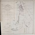
First mention of Omdurman by name on a map from 1799.

Khartoum and Omdurman around 1840: The map shows four small settlements in Omdurman.


Cityscape
The first connecting bridge to Khartoum was not built until 1928 . Today the city is connected to Khartoum by two bridges. The so-called Old Omdurman Bridge , an arch bridge , only stood in India before it was brought to Sudan by the British and rebuilt. Another bridge, called Shambat Bridge , connects Omdurman with the city of al-Chartum Bahri.
The center is the Suq Omdurman , the largest market in the country, where the main mosque is located. In Omdurman there are a number of universities and hospitals and other markets such as Suq Libia and Suq al-Shabi. Not far from the "new bridge" to Khartoum and the large parliamentary hall is the modern building of the "Nilein Mosque". The white "Mosque of the Two Niles" (the literal translation of the name) has a prism-shaped dome and is also a landmark of Omdurman.
_p483_THE_MAHDIS_TOMB.jpg)
There is also a representation center from the times of Mahdi Muhammad Ahmad, when Omdurman was the capital. There is a large square designed for gatherings in front of the two-tower Khalifa Mosque with its silver dome and the tomb of the Mahdi , a yellow box-shaped building with a silver-plated dome. Even in the run-up to the battle, Omdurman was shot at by the cannon boat guns, damaging Muhammad Ahmad's grave. As can be seen in Winston Churchill's report on the crusade against the Madhi Empire, the British general Kitchener had the tomb torn down to the ground and the Madhi body excavated. Then the head was separated from the body and the trunk was thrown into the Nile. It was only later that the British ordered the reburial of the head in Wadi Halfa. Right next to the grave is the House of Khalifa , a museum in which relics from the time of the Mahdi uprising and the occupation period, including one of the oldest automobiles in the world, can be seen.
A large number of mosques shape the image of the vast area of the city. There is a large two-towered Coptic church in the Al-Masalam district north of the central market . In Al-Mulazmeen there is also the church of an American mission . The country's radio and television station can also be found in Omdurman, in the richer Al-Mulazmeen district, right on the Nile. In contrast to Khartoum and al-Chartum Bahri, the back roads in Omdurman are mostly unpaved. They are mainly used for cars, buses and minibuses, donkey and horse carts, motorized rickshaws , pedestrians and a few cyclists.
There are also u. a. a few restaurants on the Nile or in the districts of the richer population and so-called clubs, in which there is space for large wedding celebrations and other celebrations. There are two football stadiums and at least two cinemas. Various small shops, eateries and mobile tea kitchens can be found everywhere along the streets.
The further away you get from the city center, there are fruit and vegetable stalls on the street, and cemeteries can be seen in large areas. The outskirts of the city are poor residential areas and slums. A narrow strip of agriculture is practiced on the banks of the Nile.
Universities
sons and daughters of the town
- Ismail al-Azhari (1902–1969), politician
- Abd al-Chaliq Mahdschub (1927–1971), politician
- Jafar an-Numairi (1930–2009), President of Sudan (1971–85)
- Abd ar-Rahman Swar ad-Dahab (1934-2018), President of Sudan (1985/86)
- Sadiq al-Mahdi (* 1935), Prime Minister of Sudan
- Tayba Hassan Al-Sharif (* 1963), officer of the UNHCHR
- Mohamed Badawi (* 1965), linguist, musician and educational supporter
- Kola Boof (* 1972), b. Naima Bint Harith, American writer and feminist
- Rabah Yousif (* 1986), British sprinter
literature
- Bernhard Streck : Sudan. Stone graves and living cultures on the Nile. DuMont, Cologne 1982, ISBN 3-7701-1232-6 .
- Winston S. Churchill : Crusade against the Empire of the Mahdi. Eichborn Verlag, Frankfurt 2008, ISBN 978-3-8218-4765-8 (Translator: Georg Brunold )
Web links
Individual evidence
- ↑ Page no longer available , search in web archives: bevoelkerungsstatistik.de World Gazetteer
- ↑ Omdurman . In: Encyclopædia Britannica . 11th edition. tape 20 : Ode - Payment of Members . London 1911, p. 101 (English, full text [ Wikisource ]).
- ^ F. Rehfisch: A Sketch of the Early History of Omdurman . In: Sudan Notes and Records , Vol. 45 (1964), pp. 35-47. JSTOR 41716857