
White Nile
| White Nile | ||
 White Nile in Uganda |
||
| Data | ||
| location | Northeast Africa: Burundi Rwanda Tanzania Uganda South Sudan Sudan |
|
| River system | Nile | |
| Drain over | Nile → Mediterranean | |
| source |
Luvironza (longest headwaters of the White Nile) 3 ° 54 ′ 47 ″ S , 29 ° 50 ′ 22 ″ E |
|
| Source height | approx. 2700 m (Rwandan spring river) approx. 2050 m (Burundian spring river) |
|
| mouth | Union with the Blue Nile near Khartoum in Sudan Coordinates: 15 ° 38 ′ 10 ″ N , 32 ° 30 ′ 20 ″ E 15 ° 38 ′ 10 ″ N , 32 ° 30 ′ 20 ″ E |
|
| Mouth height | 380 m | |
| Height difference | approx. 2320 m | |
| Bottom slope | approx. 0.62 ‰ | |
| length | 3762 km | |
| Catchment area | 1,588,194 km² | |
| Discharge at the Mogren gauge (1673100) - At the confluence of the A Eo : 1,588,194 km² at the mouth |
NNQ (min. Month Ø) MNQ 1973–1982 MQ 1973–1982 Mq 1973–1982 MHQ 1973–1982 HHQ (max. Month Ø) |
300 m³ / s 535 m³ / s 897 m³ / s 0.6 l / (s km²) 1161 m³ / s 1377 m³ / s |
| Discharge at the Malakal gauge (1673600) A Eo : 1,080,000 km² Location: 789 km above the mouth |
NNQ (min. Month Ø) MNQ 1912–1982 MQ 1912–1982 Mq 1912–1982 MHQ 1912–1982 HHQ (max. Month Ø) |
331 m³ / s 585 m³ / s 939 m³ / s 0.9 l / (s km²) 1288 m³ / s 2396 m³ / s |
| Left tributaries | Bahr al-Ghazal | |
| Right tributaries | Sobat | |
| Flowing lakes | Lake Victoria , Lake Kioga , Lake Albert | |
| Big cities | Jinja , Juba , Khartoum , Kigali , Kusti , Malakal , Omdurman , Rabak | |
| Medium-sized cities | Bur | |

The White Nile is one of the two main source rivers of the Nile . It rises in the mountains of Rwanda and Burundi , then flows through Tanzania , Uganda , South Sudan and unites with the Blue Nile to form the Nile at Khartoum in Sudan .
The White Nile gets its water from the always humid tropics of Central Africa and to a small extent via the Sobat also from the alternately humid tropics of East Africa .
Compared to the Blue Nile, the White Nile has a catchment area that is more than five times the size and, at around 3800 kilometers, more than 2.5 times the length and is therefore mostly regarded as the actual Nile, despite the lower water flow. Its source river above Lake Victoria is almost 900 km long, between Lake Victoria and Khartoum it has a length of 2870 km.
"Caput Nili querere"
In Roman times, Caput Nili querere was a saying for "doing something senseless". The search for the sources of the Nile is a geographical undertaking that has changed since the first discussion about its sources by Herodotus (quote: “None of the Egyptians, Libyans or Greeks with whom I spoke about them wanted anything from the sources of the Nile know ... “) lasted almost 2400 years. The ancient Greek poet Aeschylus speaks about "Egypt nourished by the snow" and Aristotle locates the sources of the Nile as a "secret of the Silver Mountain" (possibly glaciated Ruwenzori ??).
Naming
Strictly speaking, the White Nile is just the name of the Bahr al-Abiad ( Arabic White River ) between the No Lake in the Sudd and the union with the Blue Nile near Khartoum. In common parlance, however, the name refers to the river between Lake Victoria and Khartoum and often also includes the source rivers above Lake Victoria.
Source rivers
The White Nile arises from the headwaters of the largest tributary to Lake Victoria, the Kagera (in the upper reaches also Akagera ), which in turn is fed by two headwaters in the high-lying hill countries of Rwanda and Tanzania . These spring branches, which have different names in the course of the process, are also referred to as:
- Burundian source river (longer)
- Rwandan headwaters (larger)
Burundian source river: Luvironza-Ruvuvu
The Ruvuvu (also Ruwubu , Ruwuwu or Ruvusu ) forms with the tributary Luvironza the southernmost and with at least 400 km longest source river of the Kagera and thus the Nile; its total length is measured over this flow path. The source of the Ruvuvu is located at an altitude of about 2240 m in a high valley basin in the eastern edge of the East African Rift Valley . The Luvironza rises about 45 km east of Lake Tanganyika between Bururi and Rutana . A first significant right side stream is somewhat longer than it is, so that its source is set as the most distant source of the Nile and is marked with a pyramid-shaped monument. After the confluence of the Luvironza, the Ruvuvu essentially flows northeastward and is navigable for the last few kilometers. It flows into the Kagera after a winding course, which is bordered by long stratified ridges and swampy alluvial plains.
Rwandan source river: Rukarara-Mwogo-Nyabarongo-Akagera
The Rukarara-Nyabarongo , already called Akagera in the lowest section , forms the northern and shorter, but somewhat richer source river of the Kagera. The source of the upper reaches, the Rukarara, was found by Richard Kandt in 1898 in southern Rwanda (around 185 km further north than that of the Burundian headwaters). This spring, also known as the Source du Nil, is located on the eastern shoulder of the East African Rift at an altitude of about 2700 meters in the Nyungwe Forest , an important tropical mountain forest area about 40 km southeast of Lake Kiwu . The east-flowing Rukarara flows after 50 km into the somewhat smaller, north-flowing Mwogo . After a valley narrow the river is then called Nyabarongo (also Njawarongo ). With the confluence of the large Mukungma, coming from the north from the rainiest part of the Kagera catchment area, the Nyabarongo turns abruptly to the east. The former course further north was blocked with the formation of the Virunga volcanoes , and the river system as a whole was gradually tipped to the east with the rising edges of the East African Rift. The Nyabarongo later flows a short distance around Rwanda's capital Kigali . From there it is partially navigable, as is the 165 km long Akanyaru (also Akanjaru ) flowing in from the south . The Nyabarongo is later followed by the Rwandan border to Burundi and Tanzania. The sedimenting river creates niche lakes in many side valleys. The largest is the Rugwero lake ( Lac Rweru ) near the shore ; from then on the river bears the name Kagera (or Akagera ).
Kagera Nile
Just one kilometer below the junction of the two source rivers, the Kagera falls in the Rusumo Falls ( Chutes Rusumu ) through a cliff and bends significantly to the north. The now more than 230 km navigable border river flows through mostly swampy valley and basin landscapes and passes the Akagera National Park . At the “north bend” the course of the river bends again at an acute angle to the east. Flowing northeast in northern Tanzania, it reaches the west bank of Lake Victoria via numerous rapids after another 290 km. The catchment area of the Kagera (approx. 60,000 km²) drains most of Rwanda, half of the state of Burundi, but also small parts of northwestern Tanzania. In the past, the Kagera was often not regarded as part of the Nile, despite its total length of well over 900 km and a water flow of over 230 m³ / s.
Sections of the White Nile
Victoria Nile, Kyoga Nile and Albert Nile
Lake Victoria was only formed about a million years ago in the shallow depression between the two main arms of the East African Rift. During the dry coldest phases of the ice / cold ages , the lake could fall dry. After the end of the Würm glacial period , the lake overflowed north about 12,000 years ago and came into contact with the river system of the White Nile.
The Victoria Nile , which leaves Lake Victoria in Uganda to the north, is dammed a little below the former Owen Falls and Ripon Falls so high that the lake level of Lake Victoria is also slightly raised. Below the Bujagali rapids, the river passes the shallow Lake Kyoga , which is a section of the valley flooded by tectonic subsidence. As Kyoga-Nile, it overcomes an 85 km long descent including the Karuma Falls and the Murchison Falls (also Kabalega Falls , located in the Murchison Falls National Park ) 350 meters in altitude and then reaches Lake Albert in a slow run . In the following section, the Nile gets its name from this lake named after the Prince Consort of Queen Victoria of Great Britain .
Bahr al-Jabal
From the border with South Sudan, the course of the river is called Bahr al-Jabal ( Arabic : mountain river ; also Bahr al-Jabal, Bahr el-Jebel ). After a further downhill section of around 150 km, rich in smaller rapids, it leaves the highlands near the city of Juba . At the city of Bur it enters the swamp area of the Sudd , which extends more than 300 km to the north. Here 51% of the Nile water evaporates, whereby the water flow decreases from 1048 m³ / s to 510 m³ / s.
Bahr al-Abiad
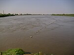
Shortly before leaving the Sudd, the Bahr al-Jabal meets the long but arid river Bahr al-Ghazāl (2 m³ / s) coming from the left in the No Lake and is from there on as Bahr al-Abiad ( White Nile ), which now initially continues to flow eastwards. At the town of Malakal , the unfinished Jonglei Canal and the strong, clay-colored Sobat (412 m³ / s) flow to the right . Then it flows northwards towards Khartoum . It forms the border between South Sudan and Sudan over a length of about 30 km.

Cities on the banks of the White Nile
- Rwanda
- Uganda
- South Sudan
- Sudan
- Kusti
- Rabak
- Khartoum (al-Chartūm)
- Omdurman (Umm Durmān)
Association with the Blue Nile
Between Khartoum and Omdurman it unites with the Blue Nile, which comes from the right (southeast) from Ethiopia . Thereafter, the river is referred to as the Nile or as Nahr an-Nīl ( Arabic : Nile River ).

Dominance of the White Nile (below) over the Blue Nile (right) in the dry season (April)
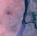
Dominance of the Blue Nile over the dammed White Nile in the rainy season (August)

The Nile near Khartoum around 1910
The confluence of the White and Blue Nile in 2010


Hydrometry
The flow rate of the river was measured for 70 years (1912–1982) at the Malakal gauge, shortly after the Sudd at around 2/3 of the catchment area, in m³ / s. The water flow decreases in the further course due to irrigation and evaporation. In addition, the White Nile hardly gets any further water until it converges with the Blue Nile in arid Sudan.
Tributaries
|
Left (here western) tributaries:
|
Right (here eastern) tributaries: |
water falls
The upper reaches of the White Nile runs in a tectonically troubled area and has been subject to many changes in the recent geological past. This is reflected in the unbalanced longitudinal profile of the river with numerous smaller and larger waterfalls and rapids . This includes:
- Rusumo Falls (Chutes Rusumu) on the border of Rwanda and Tanzania
- Kuruma Rapids in Tanzania - east of the north knee of the Kagera
- Ripon Falls in Uganda - ( flooded by Lake Victoria by the Owen Falls Dam )
- Owen Falls in Uganda - (flooded by Lake Victoria by the Owen Falls Dam)
- Bujagali Falls in Uganda - below the Owen Falls Dam (flooding dam under construction)
- Murchison Falls (also called Kabelega Falls ) in Uganda
Hydraulic engineering interventions and conflicts of use
The Sudd marshland in South Sudan represents a major obstacle to shipping. The Jonglei Canal , which has been under construction for decades with interruptions, was intended to remedy this situation and reduce the high natural evaporation losses through accelerated runoff. At the same time, this would mean extensive drainage of the marshland with serious consequences for fauna and flora and with hardly assessable regional climatic effects.
Since on average only a good five percent of the discharge below the Atbara estuary reaches the Mediterranean Sea, an intensification of the conflicts over water distribution is foreseeable. In 1959, Egypt and Sudan determined in bilateral negotiations that the total annual amount of available water from the Nile averages 84 billion m³, of which an average of 10 billion m³ would be lost through evaporation and seepage. The water throughput (around 2660 m³ / s) was measured at the height of the old Aswan Dam . Egypt approved 55.5 billion m³ annually and granted Sudan 18.5 billion m³. However, since the Nile has ten riparian states, most of which were not mentioned in the agreement of 1959, there is an undersupply for the majority of the approximately 300 million river residents, as Egypt wants to enforce its water claims by force if necessary. The Nile Basin Initiative , which has existed since 1999 , attempts to bring about partnership-based arrangements, but the existing imbalance, in which Egypt and Sudan are reserved around 88% of water use, whereas Ethiopia, from whose national territory around 90% of the runoff originate, is only a minimal one Use is allowed, is now expressed in a separate framework agreement of the upstream states from 2010 with the aim of greater personal use ( Entebbe Agreement ). The Ugandan hydropower plant under construction below the Bujagali rapids of the Victoria Nile is another such increased use.
story

The ancient Romans were already looking for the sources of the huge river ("caput Nili quaerere", ambiguous in Vulgar Latin, since it can also be translated as "looking for the head of nothing"). In the second century after the turn of the times, Claudius Ptolemy wrote based on travel reports that the Nile flows out of two large inland lakes near the equator. The Montes Lunae rise near the lakes. This statement and his world map were followed by Arabic and European representations of the Middle Ages.


Many Africa explorers have tried to find the real source of the (White) Nile. During an expedition that lasted from 1821 to 1822, the Frenchman Frédéric Cailliaud reached the confluence of the Blue and White Nile. Linant de Bellefonds, who lived in Egypt, pursued the White Nile upstream in 1827, but was prevented from advancing further at the 13th parallel due to local hostilities. In 1861, the Dutch African explorer Alexandrine Tinné put together an expedition in Cairo , but had to break it off after a few months for logistical reasons. In 1866 the British explorer David Livingstone set out on expeditions to the sources of the Nile and the Congo ; he thought he had found it in Lake Bangweul , much further south, but never reached the real source. In 1857 the British John Hanning Speke and Richard Francis Burton went on a joint exploration of Lake Victoria: John Speke saw it as the source, Richard Burton saw it in Lake Tanganyika to the south . In 1858 John Speke, now accompanied by James Augustus Grant , went on an expedition again, and in 1862 they discovered the Ripon Falls in the north of Lake Victoria, which was mistakenly regarded as the source of the Nile. The source of the Kagera-Nile on the Burundian Luvironza, which corresponds to the most distant Nile source, was discovered jointly by Oskar Baumann and Oskar Lenz in 1893 , but was not precisely determined. In 1898 Richard Kandt discovered the Rukarara spring (Rwandan spring river) in the Nyungwe forest . It was not until 1937 that Burkhart Waldecker (1902–1964) determined the exact geographic location of the Luvironza spring . The Briton Samuel White Baker and the Italian Romolo Gessi , who also went on the search, have also undertaken successful expeditions.
fauna

The Nile is inhabited by over 120 species of fish, which are not many for a river of this length. Endemic about a quarter of the species, an endemic genus does not exist. The Nile valley does not form a zoogeographical unit, around 75 species are also found in the Niger river basin and most of these species are also found in other West African rivers. More than 20 species of fish living in the Nile are also at home in the Congo Basin . One of the great living in the Nile fish species are plankton -eating African arowana ( Heterotis niloticus ) and the predators gymnarchus ( Gymnarchus niloticus ) and Nile perch ( Lates niloticus ). The quiver catfish are represented by two species, Malapterurus electricus and Malapterurus minjiriya . The most species-rich fish family are the carp fish (Cyprinidae) with 18 species and the Nilhechte (Mormyridae) with 16 species.
Many other animal species were named after the river, such as the Nile crocodile , the Egyptian goose , the Nile grass rat , the Nile monitor and also the hippopotamus or hippopotamus .
bridges
In Sudan, the railway from Port Sudan to Khartoum and Wadi Halfa with the branch from Khartoum via Sannar and Kusti to El Obeid with the An-Nil-al-azraq bridge over the Blue Nile in Khartoum and the Kusti was established at the beginning of the 20th century -Railway bridge built over the White Nile.
Above Khartoum there are now three road bridges over the White Nile in Sudan.
South of Sudan there are only five fixed crossings over the White Nile.
channels
- Jonglei Canal (unfinished)
See also
literature
- Georg Brunold: Nile fever. The race to the sources. Eichborn, Frankfurt am Main 1993. ISBN 3-8218-4107-9 .
- The discovery of the source of the Nile . In: The Gazebo . Issue 24, 1863, pp. 383 ( full text [ Wikisource ]).
Web links
- Friedhelm Hoffmann : Nile. In: Michaela Bauks, Klaus Koenen, Stefan Alkier (eds.): The scientific Bibellexikon im Internet (WiBiLex), Stuttgart 2006 ff., Accessed on May 26, 2012.
- Sofian Philip Naceur: Who Owns the Nile? In: Telepolis , June 28, 2013.
- Flow diagram El Ekhsase ( Memento from September 4, 2004 in the Internet Archive ) (English)
Individual evidence
- ↑ Length of the Nile = 6852 m minus the length of the Nile from Khartoum of 3090 km.
- ↑ a b GRDC - Mogren gauge
- ↑ a b GRDC - Malacal level
- ↑ Egon Friedell : Cultural History of Egypt and the Ancient Orient . dtv, Munich 1982, ISBN 978-3-406-58465-7 .
- ↑ Herodotus: Nine Books of History . Ed .: Goldhagen. The second book "Euterpe", No. 25 . Georg Müller, Munich / Leipzig 1911, p. 136 .
-
↑ The commemorative plaque on the pyramid bears the following inscription:
PYRAMI [DIS]
AD
CAPUT [IN] NILI
UT SIGNUM INCIPIENTIS FLUMINIS PYRAMIDUM
---
ERECTA AD MDCCCCXXXVIII
SUB PROTECTIONE PROCONSULIS JUNGERS
ET CUM AUXILIO PATRIS COLLE BURARDINQUE
ET MONTEYKNEQUE
IN MEMORY OMNIUM QUAERENTIUM CAPUT NILI
ERATOSTHENES PTOLEMAEUS
SPEKE STANLEY KANDT ET ALII
---
SUNT NOMINA NILI
KASUMO-MUKASENYI-KIGIRA
LUVIRONZA-RUVUBU-KAGERA
LAC VICTORIA-VHRTORIA
NILE-LACITA
-KIRAD
NIL
---
CFL-GEOMINES-UMHK - ↑ FAO page on the catchment area of the Kagera
- ^ Mamdouh Shahin: Hydrology and Water Resources of Africa (= Water science and technology library. Vol. 41). Kluwer Academic, Dordrecht / Boston 2002, online on Google Books
- ↑ Geof Magga: Uganda: Ethiopian led river Nile agreement signed without Egypt and Sudan. In: afrik-news.com , May 14, 2010 (English).
- ↑ Fishbase Species in Nile ( page no longer available , search in web archives ) Info: The link was automatically marked as defective. Please check the link according to the instructions and then remove this notice.
- ^ Petru Bănărescu: Zoogeography of Fresh Waters. Aüla-Verlag, Wiesbaden 1990, ISBN 3-89104-480-1 , p. 1137.