
Cairo
|
القاهرة Cairo |
||
|---|---|---|
| Coordinates | 30 ° 3 ' N , 31 ° 14' E | |
| Symbols | ||
|
||
| Basic data | ||
| Country | Egypt | |
| al-Qahira | ||
| ISO 3166-2 | EG-C | |
| height | 68 m | |
| surface | 606 km² | |
| Metropolitan area | 5360 km² | |
| Residents | 9,153,135 (2017) | |
| Metropolitan area | 20,439,541 (2011) | |
| density | 15,104.2 Ew. / km² | |
| Metropolitan area | 3,813.3 Ew. / km² | |
| politics | ||
| governor | Galal Mustafa Mohamed Said | |
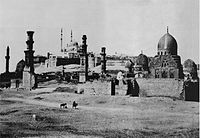
 Cairo as seen from the minaret of the Ibn Tulun Mosque . In the center of the picture the Sultan Hasan Mosque and the Al Rifa'i Mosque , on the right on the hill of the citadel the Muhammad Ali Mosque .
|
||

.jpg)
Cairo ( Arabic القاهرة, DMG al-Qāhira 'the strong' or 'the conqueror', probably after Mars, Arabic القاهر, DMG al-Qāhir ) is the capital of Egypt and the largest city in the Arab world . It was founded in 969 by the Fatimid general Dschauhar as-Siqillī . The Egyptians often simply use the country name - Arabic مصر, DMG Miṣr , Egyptian-Arabic Maṣr - designated.
Cairo is the political, economic and cultural center of Egypt and the Arab world . The city is the seat of the Egyptian government, parliament , all state and religious central authorities ( Mogamma ) and numerous diplomatic missions. Cairo is Egypt's most important transport hub and has numerous universities, colleges, theaters, museums and monuments. The old town of Cairo is an ensemble of Islamic architecture and has been recognized by UNESCO as a World Heritage Site since 1979 . The city has the status of a governorate and is ruled by a governor who is appointed by the president.
Cairo has 9.1 million inhabitants in the administrative metropolitan area (2017) and the metropolitan region of Cairo with around 16.2 million inhabitants (2009) is the largest in Africa, ahead of Lagos in Nigeria . In Egypt, however, there is no compulsory registration, which is why the specified population figures are extrapolations based on the census results. Unofficial estimates put up to 25 million inhabitants for the metropolitan area, which would mean almost a third of the total population of Egypt.

geography

location
Cairo has an area of 606 square kilometers and is located in the northeast of the country on the right bank of the Nile, an average of 68 meters above sea level . The city also includes the two islands of Gezira (الجزيرة, with the district of Zamalek ) and Roda (الروضة). Opposite it, on the western bank, is the al-Gīza (el-Gīza) governorate, including the historical complex of Giza . The geographic coordinates of Cairo are 30 ° 03 'north latitude and 31 ° 15' east longitude.
The first settlement was originally built between the Muqattam foothills in the east and the Nile in the west. But even if these have not delimited Cairo for a long time, the districts that are located between these two natural barriers form the old city center. The Nile Delta stretches north of the city to the Mediterranean Sea. To the west are the pyramids of Giza . To the south is old Memphis .
geology
Cairo is located in the valley of the Nile , the world's longest, but not richest river, the source of which is the Kagera, which rises in the highlands of Rwanda . The course of the Nile follows a tectonic line. The plateaus located there break off in steps or with a uniform steep slope 100 to 140 meters deep. In the valley, the river has formed a series of gravel terraces and deposited an alluvial plain of black mud averaging ten meters thick.
The total width of the valley is in the south, in the area of the Nubian sandstone, two to five kilometers, in the area of the tertiary limestone, about from Aswan downstream, ten to 15 kilometers. In places, the erosion of the river has reached the resistant rock of the crystalline substructure. To the west of today's valley remains of an older Nile valley have been preserved, for example in the Fayyum valley, which is fed by the river . Below Cairo, the valley opens up and merges into the wide, canal-crisscrossed areas of the 23,000 square kilometer delta.
City structure
Downtown
The city center can be roughly divided into a traditional and a modern part. Traditional Cairo is located off the Nile in front of the Citadel and Mount Muqattam (المقطّم). It mainly includes Islamic Cairo around the Azhar and other mosques. Furthermore, the residential areas north, east and south of the area around the al-Azhar mosque should be mentioned, such as Bāb el-Chalq (باب الخلق), Darb el-Ahmar (الدرب الأحمر), el-Mūskī (الموسكي) or Sayyida Zeinab (السيّدة زينب, es-Sayyeda Zēnab ).

In addition to the excavations of al-Fustat in the south is the Coptic Quarter or Old Cairo (مصر القديمة, High Arabic Misru l-qadīma , Egyptian-Arabic Masr el-edīma ). A special feature is the City of the Dead, southeast of the Islamic Quarter, a necropolis that is inhabited and today (almost) looks like a normal city quarter.
Modern Cairo is made up of the business districts led by Mīdān et-Tahrīr (ميدان التحرير), the Mīdān el-Ōperā (ميدان الأوبرا), the Ramses train station (محطة رمسيس, Mahattat Ramsīs ) and the Nile. These areas are still characterized by colonial architecture, a Mediterranean style. To the west of this is the Zamalek district (الزمالك, ez-Zamālek ) on the island of Gezīra , to the southwest lie the island of Roda and the Garden City (جاردن سيتي), where many embassies are housed.
Suburbs
The most famous suburb is Heliopolis (مصر الجديدة, High Arabic Miṣru l-Jadīda , Egyptian-Arabic Masr el-Gedīda ) in the northeast of the city. In the south is the Maadi planned in colonial times (المعادي, al-Maʿādī ), which is characterized by numerous villa plots with surrounding gardens and is therefore one of the more expensive residential areas. To the south is the Helwan , part of the Cairo Governorate (حلوان) on. Another suburb is Shubra al-Khaimah (شبرا الخيمة, Schubrā al-Khaimah ) in the north.
Further afield, a distinction must be made between former villages and cities that have integrated into the periphery of Cairo and the satellite cities planned on the drawing board , some of which are directly connected to Cairo, some of which are up to 50 kilometers from the city center in the desert.
For the latter, Nasr City (مدينة نصر, Mādīnat Nasr ) and the city of May 15 (مدينة ١٥ مايو, Mādīnat Chāmāstaschar Māio ), on the western side the city of October 6th (مدينة ٦ أكتوبر, Madīnat Sitta Oktobar ) and Sadat City (مدينة السادات, Madīnat es-Sādāt ). The city of October 6th belongs to the newly established governorate as-Sadis min Uktubar , which also includes the Bahariya oasis . Sadat City is part of the Al-Jiza governorate .
New Cairo
The New Cairo urban planning project, which has been running since 2004, goes far beyond the usual project planning for a suburb. It is the answer to the perceived narrowness, the lack of living space, the noise and sometimes inhospitableness of the old districts of Cairo. Around 17 to 28 kilometers east of the city center, private investors are invited to use the developed building sites on a hilly desert area of around 120 square kilometers until recently.
Accessible through a radial expressway system, ground-level sectors of at least 240 Feddan (equivalent to 100 hectares) are tackled in one go, their networking is guaranteed in the master plan grid. When it is completed after 2020, this modern relief city is expected to accommodate 2 to 2.4 million people. A social and leisure-oriented infrastructure corresponding to modern requirements is planned, with regional supply through shopping centers, public green spaces and club-operated sports centers, characterized by an above-average quality of the apartments , homes and villas. The first sections will be finished in early 2011: a campus university, several settlements or sub-settlements and some private schools in various European countries. What is striking is the rapid pace of development, the sections grow in unimaginably short periods of time by European standards. In terms of rental and purchase price levels, New Cairo is likely to become predominantly an urbanization for new medium-sized businesses and for foreign skilled workers.
On January 6, 2019, the eve of Orthodox Christmas, the newly built Nativity of Christ Cathedral was inaugurated in New Cairo . It is the largest cathedral in the Middle East and was funded by the Egyptian state.
climate

Cairo is located in the subtropical climate zone . The region has a warm and dry desert climate. The annual average temperature is 21.7 degrees Celsius, the annual rainfall is 24.7 millimeters on average. The warmest month is July with an average of 28 degrees Celsius, the coldest is January with an average of 13.9 degrees Celsius. Some precipitation falls only between November and March with an average of 3.8 to 5.9 millimeters.
In summer, from May to September, it gets very hot, with sandstorms coming from the south of the country. The temperatures reach daily highs of up to 35 degrees Celsius with a daily sunshine duration of up to 13 hours on average. At night the temperatures do not drop below 20 degrees Celsius. In the period from October to April, the daily highs are 20 to 28 degrees Celsius on average with daily sunshine of nine to eleven hours. In winter, from December to February, the average maximum daily temperatures sometimes fall below 20 degrees Celsius and the night minimum temperatures below ten degrees Celsius on average.
In December 2013, Cairo was hit by snowfall for the first time in over a hundred years .
| Cairo | ||||||||||||||||||||||||||||||||||||||||||||||||
|---|---|---|---|---|---|---|---|---|---|---|---|---|---|---|---|---|---|---|---|---|---|---|---|---|---|---|---|---|---|---|---|---|---|---|---|---|---|---|---|---|---|---|---|---|---|---|---|---|
| Climate diagram | ||||||||||||||||||||||||||||||||||||||||||||||||
| ||||||||||||||||||||||||||||||||||||||||||||||||
|
Average monthly temperatures and rainfall for Cairo
Source: wetterkontor.de
|
|||||||||||||||||||||||||||||||||||||||||||||||||||||||||||||||||||||||||||||||||||||||||||||||||||||||||||||||||||||||||||||||||||||||||||||||||||||||||||||||||||||
history
prehistory

Cairo's origins lie in several settlements. In today's urban area was the place Cheri-aha , where, according to Egyptian mythology, the gods Horus and Seth fought each other. The ancient Egyptian settlement on the east bank of the Nile - the place was called " Babylon in Egypt " - was founded in the 1st century AD under the Romans at the time of Trajan and later expanded into a fortress. The name Babylon originated from a misreading of the ancient Egyptian place name "House of the Nile of Heliopolis ". Atum and the Ninth were venerated in Babylon . At the end of the 4th century, the first Copts began to build churches and protective walls and settle there.
On April 9, 641, the Arabs captured the Eastern Roman fortress . Upon their arrival they found a huge castle complex with 42 churches, large towers and bastions. In the immediate vicinity of it, ʿAmr ibn al-ʿĀs founded the Fustāt camp in 643 , which gradually developed into a city. Both settlements grew together over time. While there is hardly anything left of the early Islamic city of Fustāt apart from the remains of the wall and the ʿAmr-ibn-al-ʿĀs mosque , the Coptic quarter has been preserved to this day.
Until the end of the 9th century, the place was a caravan camp and base and was of little importance for the Islamic rulers in Damascus (until 750) and Baghdad (from 750). The city experienced a first small boom under the Tulunids , to whom Fustāt served as the capital and who founded the settlement al-Qatāʾiʿ in the immediate vicinity. Two buildings from this period are still preserved: the Ibn Tulun mosque and the Nilometer . After this city was partially destroyed by fire, the Abbasids built another settlement on the Nile.
The foundation of Cairo by the Fatimids

After the Fatimids under Dschauhar as-Siqillī wrested Egypt from the Ichschidids in 969 , they built a new rectangular military camp four kilometers northeast of Fustāt. As reported by al-Maqrīzī , construction work began on July 6, 969. To the north of this camp, which was called like the North African residence of the Fatimid imam caliph al-Mansūrīya , Jawhar laid a musallā . Inside the camp he built a Friday mosque , where the Friday prayer was performed for the first time in June 971 .
After Dschauhar repelled the most important Qarmatian attacks on Egypt, the Fatimid imam caliph Abu Tamim al-Muizz made preparations in the summer of 972 to move his capital to the Nile. In the spring of 973, Dschauhar built a magnificent palace in the new camp city, which the Imam Caliph moved into in the summer of the same year. On this occasion, the new palace city was renamed al-Qāhira al-Muʿizzīya ("the Victorious of Muʿizz"). In the short form al-Qāhira , this has remained the name of the city to this day. The mosque built by Dschauhar, which has been known as the Azhar mosque since 1010, is the main mosque of Cairo to the present day and is the seat of the well-known al-Azhar University .
The new city was now the political center of an empire that stretched from Morocco to the Middle East . Fustāt also benefited from the political importance of the new neighboring city and developed into an international trading center. The Arab geographer al-Muqaddasī (946–1000) describes the city in the "Report on the things that I have seen with my own eyes" in 988 with the words:
“Al-Fustat is a metropolis in every respect (...). It lies on the dividing line between the Maghreb and the residences of the Arabs, its territory is extensive, it has many inhabitants, its area is flourishing, its name is famous, its reputation is enormous. It is the metropolis of Egypt, overshadows Baghdad, is the pride of Islam, the trading center of the people and more magnificent than the city of peace. ”(Note: Baghdad is meant)“ It is the treasury of the Maghreb and the warehouse of the East and shiny at the festive season. There is no metropolis that is more populous; many great and respected men live in it. It has amazing goods and specialties, beautiful markets and shops, not to mention the baths. (...) there is fine food, pure ingredients and cheap sweets, lots of bananas and fresh dates, plenty of vegetables and firewood, light water and healthy air. "
The great importance of Fustāt as an international trading center is also evident from the texts found in the geniza of the Ben Esra synagogue in Fustāt . In the course of time, however, Fustat was overtaken in its economic importance by Cairo.
Only a few buildings have survived in Cairo from the Fatimid period, including the al-Hākim mosque and the al-Aqmar mosque . When Saladin (1137–1193) later returned Egypt to the Abbasid Caliphate of Baghdad in 1171 , Cairo became an important center of Sunni Islam. For Saladin, who had taken over the leadership of the Arab world with the Ayyubid conquest of Cairo, the top priority was to eradicate the Shiite influence of the Fatimids. He had new mosques and schools built and laid the foundations of the later citadel. The Ayyubids were followed in 1250 by the Mamluks who made Cairo the capital again. They had many palaces, mosques and caravanserais built to demonstrate their power. Cairo became the most important economic and cultural center in the Islamic world.
In 1304 the tomb complex of Salar and Sandjar al-Jauli and in 1345 the tomb mosque Aslam as-Silahdars of the Emir Aslam al-Baha'i as-Silahdar was built.
Ottoman and British rule

After the Battle of Raydaniyya , Cairo was conquered on April 13, 1517 by the Ottoman forces, whose reign in Egypt lasted until the late 18th century. Egypt becomes an Ottoman province and Cairo is becoming less important politically. On July 24, 1798, French troops under Napoleon Bonaparte (1769-1821) took control of Cairo during his Egyptian expedition . On June 18, 1801, the city came back under Ottoman rule.
A real change in meaning took place for Cairo in the 19th century with the emergence of the Khedive Empire. Ismail Pascha , who ruled between 1863 and 1879, had numerous buildings erected in the city and took the opening of the Suez Canal in 1869 as an opportunity to present Cairo to the European powers as a flourishing metropolis. Most of the development, however, was financed through foreign bonds, which increased the influence of Great Britain in particular .
During the reign of Ismail Pasha, Cairo, which has now become the capital again, expanded westward across the Nile. European architects were commissioned to renovate the city, the Zamalek and Muhandisin residential areas were built, but large parts of today's inner city also date from this period. With the now accelerated industrialization of Egypt, the capital of the country grew more and more. By the end of the 19th century, Egypt's external debt and the weakness of the Ottoman Empire resulted in a growing European influence in Cairo.
With the occupation of Egypt by British troops and the defeat of the Urabi movement (1881–1882), Great Britain took power without ending its formal assignment to the Ottoman Empire. The Khediv of Egypt remained formally a vassal of the Ottomans. The Urabi movement came into being in the fall of 1881 when, after the financial ruin of Egypt under Ismail Pasha, the country came under international financial control. The movement turned against this international control of financial and economic policy and the autocratic rule of the Muhammad Ali dynasty .

City map from 1847
View over al-Qarafa , the "city of the dead", to the citadel with the still unfinished alabaster mosque (1856)
Abd-ar-Rahman Mosque (1887)

Photographed from a balloon in 1904, the new Egyptian Museum on the right

.jpg)

At the beginning of the 20th century, Cairo became the cultural capital. Even fine English society was drawn there. Until the beginning of the First World War there was a lively artistic creation. On December 18, 1914, Great Britain officially declared Egypt a British protectorate , thus breaking the last formal ties with the Ottoman Empire. In addition, the British enforced the war economy, which led to a widespread impoverishment of the population, as food prices rose sharply due to the purchasing power of the British troops , but on the other hand, cotton prices were sharply lowered on British intervention.
When the British prevented a delegation of Egyptian nationalists headed by Saad Zaghlul ( Wafd party ) from attending the Paris Peace Conference in 1919 , there were serious unrest, strikes and a boycott of British products. Under this pressure, the British High Commissioner Allenby pushed through to grant Egypt independence on February 28, 1922 , in order to continue to protect British interests. Cairo remained the capital of the country.
After independence

The population of Cairo grew rapidly between the world wars and by the beginning of the Second World War it had reached the two-million mark. The population continued to grow in the period that followed. The beginning construction boom changed the cityscape with towering residential, commercial and government buildings. On March 22, 1945, the Arab League was founded in Cairo .
After the “Black Saturday” on January 26th, a major fire in Cairo during the uprising of 1952 , the population of Cairo skyrocketed and more and more rural refugees settled there. Numerous satellite towns emerged; a settlement crisis began and the city became a vast metropolis. Today the urban area includes places that were once several kilometers from Cairo. The city administration has started to create incentives through cheap rents and job creation, which are intended to encourage the Cairo population to relocate to the satellite cities. But for every citizen who leaves the city, there are two who are driven into the city through rural exodus.
In 1994 the United Nations World Population Conference was held in Cairo. The topic of this conference were problems that Cairo is also facing. In addition to overpopulation, this includes above all poverty and the sometimes catastrophic hygienic and ecological situation.
From 1992 onwards, Islamic fundamentalists repeatedly carried out attacks on domestic and foreign visitors in Cairo, in which people were killed. One of the most momentous attacks in Cairo occurred on September 18, 1997, when nine Germans and one Egyptian died in an attempted attack on a tourist bus in front of a museum. The aim of these extremist groups is to discourage tourists from traveling to Egypt in order to break the internal political stability of the foreign exchange- dependent country.
In 2011 protests broke out in Cairo by large sections of the population. The revolution in Egypt in 2011 was primarily directed against the authoritarian regime with a well-developed security apparatus, the lack of a voice for the citizens, and corruption in the state, economy and administration. In the same year there was an attack on the churches of Imbaba and the Maspero massacre , in which numerous members of the Coptic minority were killed.
Population development

Cairo's population has grown rapidly over the past few decades. It has doubled since the mid-1960s until today. One reason for this is, in addition to the high birth rate, the increasing rural exodus. In order to cope with the steady population growth, several satellite cities have formed around Cairo over the years .
Due to the narrow city limits, the population increase in the city has meanwhile been significantly weakened; this is mainly taking place in the numerous suburbs, which are now as populous with a total of around 8.2 million inhabitants as the city itself with 9.1 million inhabitants (2017 ). Giza alone has almost 2.5 million inhabitants. A total of 16.1 million people (2008) live in the metropolitan region of Cairo. A population of over 24 million people in the metropolitan area is expected for 2050 and over 40 million for 2100.
The following overview shows the number of inhabitants according to the respective territorial status. Up to 1877 these are estimates, from 1882 to 2006 census results and 2008 a calculation. The population figures refer to the governorate (Arabic Muhafaza) Cairo and do not include the other governorates of the agglomeration , Giza and Qaliubia .
|
|
Development of the living situation


Around half of the population of the metropolitan region of Cairo lives in so-called informal settlements , illegally built houses by rural refugees on the outskirts with insufficient infrastructure and high population density. As the presumed whereabouts of Islamic fundamentalists , they are the focus of Egyptian security policy.
While many people search in vain for inexpensive apartments, several hundred thousand apartments are empty in the region. One reason for this is that rents for old buildings have frozen at the 1950s level. The houses are therefore exposed to rapid deterioration, as the rents are insufficient to finance the repairs.
For new buildings, the rent is set by the state at such a low level that either an illegal payment is required from the tenant prior to the conclusion of the rental contract, which roughly corresponds to the amount of the construction costs for the apartment, or it is offered for sale straight away. The statutory protection against dismissal prevents their later use by the owner.
Legally, but not statistically recorded, an almost village-like living scene has formed on the flat roofs of many buildings. The residents do not have a written contract, but are tolerated. In return, they provide auxiliary services for the rent-paying residents, e.g. B. as a caretaker. Relatives and friends live in self-built huts. Pets are also kept.
The real estate speculation in condominiums also contributes to the fact that numerous apartments in the region are vacant. After government subsidies for food, energy and public transport have been dismantled , the poorer sections of the population cannot afford to rent or buy an apartment.
The poor district of Imbaba is one of the largest slums in the world.
In a ranking of cities according to their quality of life, Cairo ranked 178th out of 231 cities worldwide in 2018.
1992 earthquake
On October 12, 1992, at 3:09 p.m. local time, Cairo was shaken by an earthquake measuring 5.8 on the Richter scale . Around 550 people were killed in the quake. Thousands of buildings, mostly in the slums of the old town, were destroyed and around 50,000 people lost their homes; valuable historical buildings like the al-Azhar mosque also suffered severe damage. The epicenter of the earthquake was around 26 kilometers southwest of Cairo, near the pyramids of Dahshur . It was the strongest earthquake in Cairo since 1847.
Newer development
As the largest city in the Arab world and the capital of the most populous Arab country, Cairo was also a center of the “ Arab Spring ” from 2010. The 2011 revolution in Egypt , which largely took place in Cairo, led to the fall of the authoritarian regime of President Hosni Mubarak in 2011 . The Tahrir Square was in Cairo at the center of international reporting, partly because were taking place here violent clashes between police and protesters, and secondly, because here during the Revolution disturbing cases of public sexual violence against women occurred (and to this day happen). After Islamic and Islamist groups such as the Muslim Brotherhood were successful in the parliamentary and presidential elections in 2011 and 2012, numerous demonstrations by political opponents took place again. In 2013 there was a military coup and the dismissal of the elected president of the Muslim Brotherhood, Mohammed Morsi . The 2014 presidential election was won by the military candidate Abd al-Fattah as-Sisi , although the Muslim Brotherhood was excluded from voting. From 2010 to 2014, the security situation in Cairo was tense and the city was shaken by mostly Islamist-motivated bomb attacks. Before the anniversary of the Egyptian revolution in January 2014, six people died in four attacks. On July 11, 2015, a person died in a bomb attack on the Italian consulate. On August 20, 2015, a car bomb attack left at least 29 people injured. On December 4, 2015, at least 16 people died in an attack on a nightclub. On December 11, 2016, at least 25 people were killed in a bomb attack on Coptic St. Mark's Cathedral .
politics
City government

At the head of the governorate in Cairo is the governor personally appointed by the country's president, Abdel Azim Mussa Wazir since 2004 . He has the rank of minister and is formally the representative of the Egyptian president in the governorate. Politics at municipal and local level in Cairo are essentially carried out by two different constitutional bodies: the appointed executive council and the elected people's council.
The Executive Council is the highest administrative body in the governorate. Members are, for example, the governor, his deputy, the chairmen of the local councils and the representatives of the executive administration. The council has extensive power with numerous options for intervention and decision-making. It is the most important administrative body for planning, coordinating and implementing central government policies at the local level in Cairo.
The People's Council, elected by the population for four years, has the task of defending or representing the interests of the people vis-à-vis the administrative administration or the Executive Council. The People's Council is thus the only political organ in the local administration system that comes into being through an electoral process and is therefore fundamentally beyond any direct control of the Egyptian government. According to the constitution, no citizen surveys or other forms of citizen participation are allowed at the local level in the country.
The last local elections took place on April 8, 2002. They were initially planned for 2001, but were postponed for a year because of the parliamentary elections that took place in the same year. While in the 1997 elections the so-called independent opposition candidates , who are often close to the Muslim Brotherhood , received 20 percent of the votes cast, they boycotted the election in 2002 because of insufficient control by independent judges. This also explains the high election victory of 97 percent of the ruling National Democratic Party (NDP) of President Muhammad Husni Mubarak . The local elections planned for 2006 have been postponed to 2008. The reason is the introduction of the new law on municipal administration.
Town twinning
Cairo maintains the following cities partnerships :
City friendships
In 1979, Cairo signed a friendship treaty with the following city:
Culture and sights
languages

In Cairo, like almost everywhere else in the country, Egyptian Arabic is spoken . The Arabic spoken in the capital differs considerably from the dialects of Central and Upper Egypt. Egyptian Arabic is the most important New Arabic dialect . This is mainly because the Egyptian film industry, based in Cairo, is the largest in the Arab world. Egyptian films are shown throughout the Arabic-speaking world, with no dubbing or subtitles.
In contrast to news and the like, films are not shot in standard Arabic , the written language of the entire Arab world, but in the respective colloquial language; for most films this is Egyptian-Arabic. As a result, Egyptian-Arabic or the Cairo dialect is now understood throughout the Arab world.
Standard Arabic has been a written language since the Arab conquest in the 7th century. Only in the Coptic Church is Coptic still used as the liturgical language, which is written in its own script derived from the Greek. The language of ancient Egypt , which was continued in Coptic, is only spoken today as a sacred language. English is widely used as a foreign language and French is also used by the upper class . Due to tourism and German-speaking universities, the German language is also becoming increasingly popular.
Religions
In Cairo, the predominant religious denomination is Islam ; according to the Egyptian constitution , Sharia is the main source of legislation. In addition to the Sunni majority, there is also a Christian minority in the city. An official census of Christians is deliberately not carried out, although the religion must be entered in the passport. It is estimated that around 90 percent of the population are Sunni Muslims. The majority of the remaining ten percent are Orthodox Copts , whose St. Mark's Cathedral in the Abbassia district is now the second largest church in Africa. There are also several thousand Catholic Copts and Greek Orthodox Christians (see also: Greek Orthodox Church of St. George ). There is also a small Jewish community in Cairo. Most of the time the religious communities live more or less peacefully side by side.

The Copts, in particular, are repeatedly the target of attacks by radical Islamists , often with the knowledge of the local authorities. Many of the Islamic fundamentalists live in the informal settlements ( slums ) on the outskirts of Cairo. All Egyptians, regardless of their beliefs, have equal rights before the law. In practice, however, Muslims who convert to Christianity must expect government coercive measures. New churches may only be built by a presidential decree; this is also necessary for minor repairs.

In addition to the numerous mosques and churches, there are also many synagogues , orphaned Jewish schools, hospitals and community centers in Cairo . They are reminiscent of the time when Jews played important economic and cultural roles in the city. It was also Jews who founded the Zamalek district and the suburbs of Maadi and Heliopolis . The number of Jews in the city is now estimated at less than 100 people, a few families, most of them elderly.
At the end of World War II , there were an estimated 75,000 Jews in all of Egypt, 55,000 of them in Cairo alone, most of them Sephardic . But shortly after the end of the war there were pogroms against the minority . With the onset of the Arab-Israeli clashes, which began in 1948 with the establishment of the State of Israel , their number continued to decline sharply. Many Jews were arrested and taken to the prison in Huckstep near Cairo or to camps, Jewish magazines and newspapers were banned and Jewish property was confiscated. Most of them were quickly drawn to the newly founded state of Israel. The last wave of refugees from Jews to Israel came with the Suez Crisis in 1956 and the Six Day War in 1967.
What remains of the religious and cultural life is a small Jewish quarter, the Harat al-Yahud, in Cairo, near the Muski quarter with the Maimonides synagogue , and a huge cemetery between Maadi and the center, a necropolis from the 9th century, which is extends over 850,000 square meters. It is one of the most important cemeteries in the Jewish world.
In addition, it is estimated that between a few 100 and up to 2000 Baha'i live in the country, including many in Cairo, who see themselves discriminated by the government, as the Baha'i religion is not available on Egyptian passports, but can only be chosen between Muslim, Christian or Jewish.
theatre

Cairo is home to numerous theaters, opera and concert halls. The Khedivial Opera House built in Cairo to mark the opening of the Suez Canal in 1869 burned down in 1971. The new Cairo Opera House opened in 1988 and is now home to the Cairo Opera Company. The concert hall is also used by the Cairo Symphony Orchestra and the Cairo Opera Ballet Company. The opera house complex houses several galleries, including the Museum of Modern Art.
The "Gomhouriya Theater" was originally built as a cinema and served as an opera when the opera house was renovated after the fire. Today the building is used as a concert hall for various musical events. There are regular performances by Arab music groups and a folkloric Egyptian orchestra. The Wallace Theater, which is connected to the American University of Cairo, offers plays in English several times a year. It is also used for musical performances - from jazz to chamber music .
Another theater is the "Al-Arayes" (Cairo Puppet Theater) on Ataba Square in central Cairo. The puppet theater performances are in Arabic. Classical pieces such as Alibaba or Sinbad are performed there. The Um-Kulthum-Theater (Al-Balloon Theater) in Agouza performs folklore, Arabic plays and Egyptian folk dance.
Museums

The Egyptian Museum on Tahrir Square is one of the most famous museums in Cairo . The museum has an important collection of Egyptian art treasures from all epochs of ancient Egyptian history , such as predynastics , the intermediate times and the Greco-Roman times . Before moving to the current location, the exhibition of ancient Egyptian antiquities was housed in the museum near the Asbakiya Gardens (1835–1855). Due to a chronic lack of space, the artifacts were brought to the museum in Bulaq am Nile, where they were exhibited until the museum was damaged by the flood in 1878. After that, the exhibits were temporarily stored in Giza , in the palace of the Khedive Ismail Pasha and only partially exhibited.
The current building in Tahrir was built in 1900 by the Egyptian and British governments as a repository for found objects. The former Service des Antiques de l'Egypte (now the Supreme Council of Antiquities ) was commissioned to collect ancient Egyptian art treasures and to bring the pieces kept in the Giza Palace, the mansion of Ismail Pasha. The new building of the museum and the relocation of the exhibition were completely completed by 1902. This measure was primarily intended to stop the looting of tombs and thus preserve the valuable cultural heritage for Egypt. The key pieces of the museum are the exhibits from the grave ( KV62 ) of Pharaoh Tutankhamun . This includes chariots, jewelry, beds and other pieces of furniture. The coffins made of gilded wood and gold of the Pharaoh and the centerpiece of the collection, the golden death mask of the youthful-looking king, are the most famous attractions. Everyday objects from more than 5,000 years of history, monumental statues, mummies, sarcophagi and coins from Greco-Roman times can also be viewed. Today the museum houses the largest collection of ancient Egyptian artifacts worldwide with around 150,000 exhibits.
The Museum of Arabic and Islamic Art (opened in 1903) includes an extensive collection on early Islamic culture. The Coptic Museum , opened by Marcus Simaika Pascha in 1910 and renovated in 1984, traces the history of the Coptic community in Egypt and is built on the ruins of the Roman garrison fortress of Babylon . In the Mahmoud Khalil Museum on the west bank of the Nile, completed in 1963, works by Vincent van Gogh , Paul Gauguin , Peter Paul Rubens and other well-known European and Egyptian painters are on display.
Next to the main train station is the small two-story Egyptian Railway Museum of the Egyptian National Railway (ENR) . On the upper floor there are models of means of transport from the time before the invention of steam power, locomotives, wagons, but also models of water and air transport. The exhibits also include a model of the Khedive train from 1859 with carriages for officers, ministers and the Khedive family. Models of bridges, train stations and express locomotives from the Khedive era are on display on the ground floor. There is an original locomotive, which was made for Princess Eugenie in England in 1862, alongside other tractors. It once operated between Ra's el Tin and the Montaza Palace in Alexandria .
The Gayer-Anderson Museum next to the Ibn Tulun Mosque provides an insight into the Kariner living culture of the early modern period and the Arab-Egyptian handicrafts . The museum contains interesting exhibits from the private collection of the British medical officer Robert Grenville Gayer-Anderson, who lived in the house for several years.
Buildings
Buildings in Cairo

The city of Cairo is mostly surrounded by desert, in the north it is bordered by the Delta of the Nile . The urban area also includes a number of islands, the largest of which is the centrally located al-Gesira, on which, among other things, the opera house opened in 1869 and the 187-meter-high television tower are located. The construction of the reinforced concrete tower is reminiscent of a lotus flower. The television tower was completed in 1961 and has a viewing platform that is open to the public. Several bridges connect the island of al-Gesira with the opposite river banks.
The center of Cairo is Tahrir Square, where the Arab League building , the Oman Makran Mosque and a bus station are also located. The cityscape is shaped by many historically significant buildings. Of the several hundred mosques, the Ibn Tulun Mosque, built in the 9th century, and the Azhar and Al-Hakims Mosques (both from the 10th century) are among the most famous.
The citadel in the eastern part of the city was built on a hill by the Sultan Salah ad-Din in 1176 . Their ornate buildings are part of the Cairo skyline. The Muhammad Ali Mosque is the more notable of the two mosques in the citadel. It has multi-story domes and a double minaret made up of two of the oldest of the city's famous “Thousand Minarets”.

The Al-Aqmar Mosque in the north of Muizz Street , completed in 1125, is the first mosque in Cairo whose main axis is not oriented towards Mecca, but follows the course of the street.
In the old town of Cairo are worth seeing city gates; they are the remains of a former fortification surrounding the city. Of the original eight city gates, only three have survived (Bab al-Futuh, Bab an-Nasr and Bab Zuweila ). The markets (Suqs), many of which have specialized in certain goods such as spices, fabrics or valuable metals, combine today's economic life with traditional forms of trade and handicrafts.
Opposite the exit of the metro station Mar Girgis is the "Hanging Church", the Kanisa Mu'allaqa. It is called "hanging" because it was built over the former entrance of the Roman fort and is therefore elevated. Dedicated to the Virgin Mary, it was built in the 4th century and made a bishopric in the 7th century. It was destroyed in the 9th century, but then rebuilt in the 11th century and made the Coptic patriarchal seat. Since then it has been renovated again and again. The facade dates from the 19th century.
The Islamic old town of Cairo was included in the list of world cultural heritage by UNESCO in 1979 . Outside of Old Cairo, which is characterized by old residential areas and narrow streets, modern Cairo spreads out with high-rise buildings and wide streets.
The so-called “Cities of the Dead” , the inhabited cemeteries of Cairo, are also worth a visit . While in other Islamic countries or in Europe the dead are buried underground, the pharaonic cult of the dead has continued in Egypt : instead of burying people in the ground, houses are built for them. The more powerful and richer a person was during his lifetime, the larger and more magnificent his mausoleum . Many of the tombs have several rooms, around which a protective wall was built. The body rests in the basement in a stone sarcophagus, which is often richly decorated and adorned with verses from the Koran .
French architects started working in Cairo around the turn of the century. Georges Parcq built in 1928, the stock market ( stock exchange ) at the Cheri Fein Street , and in 1913 the residential building Sednaoui at the Midan Khazindar . Other works were the Mubarak library and the French embassy.
Pyramids of Giza


The pyramids of Giza near Cairo are among the most famous buildings of mankind. After all the other six wonders of the ancient world were destroyed , they were the last to be preserved. The pyramids are called El Ahram ("the sanctuaries") by the Egyptians and rise on a plateau, an extension of the western desert about eight kilometers southwest of the city of Giza (Gîza), a Cairo suburb. The pyramids are located around 15 kilometers from the city center, directly on the pyramid road ( Sharia el-Ahram ).
The theory of the function of the pyramids states that they were thought to be the burial sites of three pharaohs about 4500 years ago in a period of about 100 years in the 4th Dynasty . They form the center of a huge necropolis of the Old Kingdom . The middle of the three pyramids is the Chephren pyramid , while the most famous and largest is the Cheops pyramid . The Chephren pyramid looks a little larger than the actually larger Cheops pyramid because of its location about 10 meters higher. Together with the third, the Mykerinos pyramid , they were included in the list of world heritage sites by UNESCO in 1979 as a cultural monument .
The tombs are the result of a theological development and a brilliant technological achievement that no architect or structural engineer could easily imitate the old master builders. In the beliefs of eternal life, the pharaoh, who was considered the son of the sun god, was the mediator between earth and cosmos. The development of an increasingly sophisticated tomb, from the mastaba via the step pyramid to the “real” pyramid, should enable the ruler to ascend to the firmament after his death. Through the union there with his father, the sun god Re , he guaranteed strength for his people and fertility for the land. That is why he was worshiped after his passing.
To the east of a pyramid was the mortuary temple, which was connected to the valley temple via an access road. The dead Pharaoh was probably brought to the valley temple, which was in turn connected to the Nile, in a boat for embalming. A pyramid was reserved for the Pharaoh and his wife as a burial place. The pyramid represented the unrestricted power of the pharaohs and is still a symbol of the pharaonic culture.
The Great Sphinx of Giza

The Great Sphinx of Giza is probably the most famous and largest sphinx and has been sticking out of the sand of the Egyptian desert for more than four and a half millennia. It depicts a reclining lion with a human head and was made in the 4th Dynasty around 2700–2600 BC. Built in BC. The figure is about 73.5 meters long, six meters wide and about 20 meters high. The front paws alone are about 15 meters long. Paint residue on the ear suggests that the figure was originally brightly painted.
The figure was carved from the remainder of a limestone mound that served as a quarry for the Great Pyramid of Cheops . A temple was built next to the Sphinx, which is almost exactly in line with the valley temple of the Chephren pyramid . Thutmose IV erected a stele between the paws of the Sphinx, the so-called " dream stele ", the inscriptions of which tell from his life.
The origin of the Arabic name Abu l-Haul ("father of horror") is not clear. What the Sphinx was used for is also unknown, possibly it was supposed to guard the plateau of Giza. The German Egyptologist Herbert Ricke thinks that the statue belonged to the sun cult and represents Harmachis ("Horus in the horizon" - Heru-em-achet ), an aspect of the sun god Horus . The statue may also be an image of the pharaoh Chephren , represented as Horus, or an image of Cheops . Mark Lehner , who researched the Sphinx from 1979 to 1983, favors Chephren as a builder like others. The German Egyptologist Rainer Stadelmann , on the other hand, prefers King Cheops. Using the most modern methods, other images and statues of these two pharaohs have recently been compared with the head of the Sphinx, but a clear and unequivocal assignment was still not possible.
On the other hand, it seems certain that the Sphinx was viewed in the New Kingdom as an embodiment of the sun god Re-Harachte . She was buried several times in the sand of the desert and in the 19th century only the head was visible. The good preservation is probably due to this fact. But in the last few decades the more than 4500 year old Sphinx suffered greatly from the smog of the nearby metropolis and a constantly rising water table. Years of extensive restoration work have made it shine in a new "splendor".
Heliac rising of Sirius
The Sirius was with its heliacal rise from approx. 2850 BC. In ancient Egypt the bringer of the flood of the Nile . At the present time this spectacle can take place on 6./7. August (depending on visibility) can be observed.
| process | year | Gregorian calendar | Egyptian calendar |
|---|---|---|---|
| Beginning of spring | 2009 | March, 20th | 4. Schemu IV ( 4. Mesori ) |
| Sirius heliacal rise | 2009 | August 7th | 19. Achet IV ( 19th Choiak ) |
Parks
The well-tended Gabalaya Park is one of the many parks in Cairo. It was laid out in the 19th century and is now a green oasis in the city's traffic chaos. The aquariums with Nile fish carved in labyrinth-like grottos are worth seeing . The complex is also a popular picnic spot for locals and tourists.
The largest zoological garden in Africa is located next to the University of Cairo in Giza and was opened in 1891. It is home to around 400 different animal species, including King Faruk's tortoise until 2006 , said to be the oldest tortoise in the world at 270 years old . In many cases, animal husbandry is not appropriate to the species . The zoo is a popular picnic and excursion area for Cairo's residents, especially on Fridays.
"Dr. Ragab's Pharaonic Village ”is a pharaonic“ Disneyland ”, located on a 150,000 square meter site with waterways lined with papyrus plants . The exact replicas of ancient Egyptian buildings can be viewed there. Young Egyptians in traditional costumes, with tools and farm implements in the style of their ancestors, show the life and work of that time. A highlight of the attractions is the replica of the tomb of Tutankhamun .
The “Dream Park” on Oasis Road in 6th of October City, a suburb of Cairo, is one of the largest theme parks in the Middle East for the whole family, with numerous rides, attractions, shows and over 20 restaurants.
The al-Azhar Park is a garden above the al-Azhar mosque . It opened on 30 hectares in 2005 and was supported by the Aga Khan Development Network (AKDN) with $ 30 million as a gift from Aga Khan IV, whose ancestors founded the city of Cairo in 969. It is the largest public park in Cairo. Previously there was a garbage dump at this point that had piled up in 500 years. City walls from the Ayyubid period , which Saladin had built in the 12th century, were found near the park . The project also included the restoration of the Um Sultan Shaban mosque from the 14th century, the Khayrbek complex from the 13th century and the Darb Shoughlan school. There are also facilities for social and health services in the park.
Regular events

Numerous festivals and events take place in Cairo and the surrounding area throughout the year. These include the “International Egyptian Marathon” in Giza in January, the International Book Fair in February, the “Cairo International Fair”, Africa's largest trade fair, in March, and the “Documentary Film Festival” in July.
Other important events in September are the “Festival of Experimental Theater”, the “Wafa el Nil Festival”, a large folklore festival, and “World Tourism Day”, an event with music and stands at which the regions of Egypt introduce themselves.
In October, the “Pharaohs Rally”, a motorcycle rally, and the “Arab Travel Market”, a tourism fair, take place in Giza. The “International Rowing Festival”, a rowing competition on the Nile, and the “ Cairo International Film Festival ” are held in December .
In Cairo, two mulids are particularly interesting, namely the “Mulid Sayyidna Hussein” in the third Islamic month and the “Mulid Sayyida Zainab” in the second Islamic month. Both mulids are very large festivals held in honor of the grandson and granddaughter of the prophet. The Zainab Mulid is one of the largest in the country and is celebrated for several days with lots of music, Sufi dances, prayers and processions.
At the end of March, the Cairo Conference, currently one of the most important anti-war conferences in the world, takes place annually in Cairo.
Culinary specialties
Cairo is home to many restaurants that offer Egyptian as well as international cuisine. The local cuisine awaits with a particularly large selection of starters (mezze), which are served to the guest on small plates and eaten with flatbread ('aish balladi) according to local custom. The mezze often include “tamaya” (vegetable cakes) and “ful” (bean porridge), for a large part of the less-paid Egyptians daily breakfast and the most important main meal. Another Egyptian specialty is kuschari , a dish made from noodles, rice, lentils and a spicy sauce made from tomatoes and fried onions.
The meat of beef, chicken and lamb (pork is forbidden to the Muslims ) is mostly grilled on the open fire or sizzled in the stove pipe like meatballs (kofta) and “kebab”. The fish cuisine of the Mediterranean and the Red Sea is also recommended , in which barracudas, shrimp, lobsters, crabs and squids are prepared differently depending on the coastal region. A specialty of the Mediterranean coast is the heavily cured "fesich", a fish that is very tasty.
trade

The numerous shopping malls, shops and bazaars in Cairo offer a variety of shopping opportunities. Wekalat Al-Balah market has a wide variety of curtains. These are laced up to tables in many small niches, in the alleys and in large, palatial shops, often up to three layers high, supported by white columns. The Tentmakers' Bazaar, built in 1650, is Cairo's only preserved covered market. It is located south of Khan el-Khalili . Sailing products and geometric tapestries are offered there.
All kinds of clothing can be found in the large markets along the Sh. 26th July, near the October 6th Bridge, as well as in the shops between Midan Urabi and Talaat Harb, the Cairo promenade. To the right and left of the streets there are thousands of shops selling mostly Western clothing. These can also be found in various shops in the World Trade Center.
A constant fruit and vegetable market can be found near Midan Urabi, on Sh. Talaat Harb, and one at Midan Falaki, which is housed in the covered “Marché Bab el Louk”, a market hall from 1912. The largest bookstore in Egypt is located on the campus of the American University of Cairo, primarily with English-language literature on Cairo and Egypt, many travel guides, illustrated books, specialist literature on everything to do with Islam and the Orient, and a large selection of books on politics and history.
Economy and Infrastructure
economy
_in_Mohandessin,_Egypt,_Oct_2004.jpg)
According to a study from 2014, the greater Cairo area has a gross domestic product of 102.2 billion US dollars ( PPP ). In the ranking of the economically strongest metropolitan regions worldwide, it was in 131st place. Together with Johannesburg and Lagos, Cairo is one of the leading economic centers in Africa.
overview
Due to its convenient location at the hub between southern Europe , the Middle East , the Maghreb and sub-Saharan Africa, Cairo became an important trading center early on. The most important branches of production are metal processing, the cement industry, the manufacture of furniture, shoes, tobacco products and textiles as well as the printing industry. As the most important business center in the Middle East, the city is the seat of numerous corporations and business organizations. The city's largest economy is the public sector, including government, public institutions, and the military. In addition, tourism is of paramount importance. Cairo is the country's tourist center and its largest source of foreign currency income. About a third of all Egyptian industrial companies are located in the Cairo area. The city is the most important publishing center in the Middle East.
Social problems
The so-called informal economy accounts for around a quarter of all economic activity in Cairo. The retail trade, the craft, but also the infrastructure are very dependent on it. In this area, in which there is no social security and the working conditions are catastrophic, more and more women work and criminal child labor is most widespread there. The liberalization of the economy, which also included the reduction of subsidies , has worsened social living conditions. Unemployment is very high. In addition to the roughly ten percent unemployed reported by the government, there are also numerous unregistered unemployed. Estimates assume a rate of over 20 percent. A third of Cairo's population lives below the poverty line, families cannot afford a minimum of food and shelter. The people living in the urban area are relatively poorer today than in 1958.

environmental issues
Problems are caused by the inadequate infrastructure and the extremely large housing shortage caused by the rural exodus. The electricity and water supply is in a desolate state and hardly a day goes by without houses that are not in a state of disrepair. In the industry, which is concentrated in the metropolitan region of Cairo, there are insufficient disposal and cleaning capacities for sewage, exhaust gases and waste. In addition to infectious diseases such as cholera , diarrhea and typhoid , which are spread due to inadequate hygienic conditions, there are also respiratory and skin diseases due to the toxic emissions of many industrial plants and motor vehicle traffic. Particular problems arise from the often direct neighborhood of poorer residential areas and industry. The air pollution and urban sprawl historically significant areas destroy many cultural monuments of Cairo. The city administration of Cairo is trying to counteract this. Industrial companies are no longer allowed to settle in the city and the construction of high-rise buildings and large hotels is to be stopped.
Car manufacturers
In the commercial vehicle sector, the MCV Corporate Group is based in Cairo . But the oldest and largest vehicle manufacturer in the Middle East, the Ghabbour Group , is also based here and, with a 25 percent market share, is of major importance for the Hyundai Motor Company , as well as Volvo Trucks and Fuso . Behind them is General Motors Egypt with the brands Chevrolet , Isuzu and Opel . Another Cairo-based automaker is Chrysler- owned Arab American Vehicles . Almost unknown car manufacturers in Cairo are the Seoudi Group , which produces vehicles for Suzuki , Nissan and the Fiat group. Another manufacturer that mainly operates in the commercial vehicle sector is the Mod Car project . A manufacturer that has since disappeared was the Egyptian Light Transport Manufacturing Company , which assembled the NSU Prinz under the brand name Ramses for the Egyptian market.
traffic
Long-distance transport

An extensive road network connects the Egyptian capital with all major cities in the country. The most important compounds of Cairo in northwestern direction Alexandria and the Mediterranean coast are the highway no. 1 by the Nile and the desert highway number. 11. In southern direction along the Nile to Luxor runs the highway no. 2, in north-east direction by Port Said the highway no.3 and in the east direction to Suez the highway no.33.
The Cairo International Airport is located in Heliopolis , 22 kilometers northeast of the center of Cairo. Domestic flights are mainly offered by Egypt Air and small national lines, which can all be booked through EgyptAir. You can fly to Alexandria, Aswan, Luxor, Taba, Abu Simbel, Kharga, Sharm el Shaikh and Hurghada. A fleet of Embraer 170s was used on domestic flights with the newly founded subsidiary Egypt Air Express . The 12.5 km long October 6th Bridge connects the city with the airport.
The Egyptian Nile Valley can be traveled by rail from Alexandria in the north to Aswan in the south . The train is comfortable and fast by African standards. It carries travelers from the Ramses train station to Alexandria, to the Suez Canal and south along the Nile . Otherwise, the entire country can be reached from Cairo by long-distance buses. There are ten bridges over the Nile in Cairo.
The Turgoman central bus station is close to the Ramses train station. Most buses depart from there in all directions. Almost all buses going north or Sinai stop again in Heliopolis . Those who live there can also get on there first. There are also a few other small bus stations around the Ramses train station. Minibuses to El-Fayum depart north of Midan Ulali, minibuses to Port Said and Ismailiya directly south of Ramses train station on the road to Midan Ulali.
Local transport

Around two million cars drive in the very densely populated city. Daily traffic jams and high levels of environmental pollution cause problems .
tram
The Cairo Transport Authority operates two interconnected meter-gauge tram networks in Cairo and Heliopolis over a length of 30 kilometers . Since the takeover of the formerly independent Heliopolis company in 1991, all routes have been under the control of the CTA. The first tram line was opened in Cairo on August 12, 1896, and in Heliopolis on September 5, 1908. Isolated from the network in Cairo and Heliopolis, the CTA has also been operating some newly built tram lines in the industrial city of Helwan south of Cairo since February 19, 1981 with an additional 16 kilometers in length.
City buses
The Cairo Transport Authority's 2,600 buses and coaches carry 1.3 billion passengers a year. The buses run on 450 lines with a length of 8,460 kilometers. The central bus station for local transport is located in Cairo on the Midan Abdelmunim Riad between the Egyptian Museum and the Corniche. Nearby Giza can be reached by minibuses from the bus station north of Midan Ulali. The first trolleybus drove around the city in 1950. After 31 years of operation, it was closed on October 22, 1981.
metro
The first section of the metro was inaugurated on September 26, 1987. Today it runs on three lines with a length of around 65 kilometers:
- Line 1 runs north-south from New El Marg (المرج الجديدة el-Marg el-Dschadīda ) to Helwān (حلوان). It consists of two suburban lines that were connected to each other by an inner city tunnel until 1989.
- Line 2, in contrast, is a full subway: it was built in the 1990s and runs underground in the city center and above ground in the outskirts. A tunnel section runs under the Nile. The lines are also north-south - from Shubra (شبرا الخيمة Shobrā el-Chēma ) to Giza Suburban (ضواحي الجيزة Dawāhī el-Gīzā ) - however, it runs in the city center in an east-west direction. It crosses line 1 twice (stationsأنور السادات Anwar as-Sadat andالشهداء Al-Shohadaa / Martyrs ).
- Line 3 runs in an east-west direction and is intended to connect the Mohandessin and Imbaba districts with the airport. A tunnel under the Nile is also planned here. The first construction phase between Attaba (change to line 2) and Abbasiya was opened on February 21, 2012.
education

The metropolitan region of Cairo is home to numerous universities, colleges and technical colleges, academies, research institutes and libraries.
The al-Azhar University , the most famous Islamic educational institution in the city and one of the oldest and most prestigious educational institutions of the Muslim world. At the same time, she has a high level of authority in Islamic legal issues ( Sharia ) for the Sunni religion, to which 85 percent of all Muslims belong. Sheikh Muhammad Sayyid Tantawi was the head of the university until 2010 . The importance of the university can also be seen in the number of students, which is completely outside of what is usual at US or European universities: In 2004, about 375,000 students were enrolled at Azhar, almost half of them with 150,000 women . Around 16,000 lecturers teach at al-Azhar.
Other universities in the region are the University of Cairo (founded in 1908), the American University in Cairo (1919), the Ain Schams University (1950), the Helwan University (1975) and the German University in Cairo (2003) ( all in Cairo), Misr University for Science & Technology (in 6th of October City), Modern Sciences & Arts University (in Gizeh), The Arab Open University - Cairo Branch (in Nasr City) and The British University in Egypt ( in El Shorouk City).
Other important educational institutions are the Arab Academy for Science & Technology & Maritime Transport, the Cairo American College, the Canadian International College, the Khedeve Ismail Secondary School, the Modern Academy, the Police Academy and the Sadat Academy for Management & Computer Sciences (all in Cairo), the El Shorouk Academy (in El Shorouk City), the High Cinema Institute - Haram (in Giza), the Higher Technological Institute (in 10th of Ramadan City), the Modern Academy for Engineering & Technology (in Maadi) and the St Clare's College and St George's College (both in Heliopolis).
Around 1,000 schools provide general education in Cairo. Schooling in Egypt is guaranteed as a fundamental right in the constitution. The six-year compulsory schooling from the age of six, which had existed since 1923, was reduced to five years in 1991 due to a lack of teachers. The subsequent six-year secondary school entitles you to university entrance. The Egyptian equivalent of the German Abitur is the "ṯanāwīya ʿāmma". Elementary and secondary school are generally free of charge. The efforts in education resulted in statistics showing that the primary school enrollment rate was almost 100 percent. At least 75 percent of the children of the corresponding age are still enrolled in secondary school . However, these figures somewhat obscure the reality in Cairo schools, as there are numerous school dropouts (up to 30 percent). Children often have no time for school because, although forbidden, many children work to help support families, mostly living in poorer neighborhoods and informal settlements on the outskirts. The quality of school education also leaves a lot to be desired. Classes with more than 70 students are not uncommon. The poorly paid teachers are unmotivated because they can hardly live on their salaries.
Although Egypt received the UNESCO Prize for Fighting Illiteracy in 1998 , the illiteracy rate in Cairo is still very high. Especially for adults aged 15 and over, the estimates are between 40 and 50 percent. The rate for women is more than ten percent higher than for men, as the education of girls is still sometimes viewed as secondary by conservative families.
sons and daughters of the town
Cairo is the birthplace of numerous prominent personalities. These include the Italian musician and composer Miguel Ablóniz , the Canadian-Armenian director Atom Egoyan , the Palestinian politician Yassir Arafat , the general director of the International Atomic Energy Agency Mohammed el-Baradei , the eminent Arab thinker Faraj Fauda and the famous man of letters and thinkers of the Arab world Salama Moussa .
Other sons and daughters of the city are the last queen of Egypt Nariman Sadiq , the king of Egypt Fu'ad I , the actress and singer Marika Rökk , the Egyptian writers Nagib Mahfuz and Ala al-Aswani and the francophone writer Albert Cossery , the scholar of Islam , Semitist, orientalist and Catholic theologian Samir Khalil Samir , the Albanian writer and translator Andon Zako Çajupi and the advisor to Osama bin Laden and Egyptian terrorist Aiman az-Zawahiri .
See also
literature
(sorted chronologically)
- Uri Avnery , photos: Thomas Nebbia: Cairo: The lovable chaos. In: Geo-Magazin. Hamburg 1979.1, pp. 74-102. Informative report about Cairoers and Israelis with their attitude to life. ISSN 0342-8311
- Mohammed Heikal: The Cairo Dossier. From the secret papers of Gamal Abdel Nasser. Molden, Munich 1984, ISBN 3-217-00455-8 .
- Oleg V. Volkoff: 1000 years of Cairo. The story of an enchanting city. von Zabern, Mainz 1984, ISBN 3-8053-0535-4 .
- Reinhard Goethert: Cairo - On the efficiency of unofficial urban development. Deutscher Gemeindeverlag, Cologne 1986, ISBN 3-555-00670-3 .
- Hans-Günter Semsek, Georg Stauth, among colleagues. by Ahmed Zayed: Life practice, everyday experience and social conflicts: Cairo slums of the eighties. Steiner, Stuttgart / Wiesbaden 1987, ISBN 3-515-04863-4 .
- Günter Meyer: Cairo. Development problems of a metropolis in the third world. Aulis, Cologne 1989, ISBN 3-7614-1208-8 .
- Mohamed Sharabi: Cairo. City and architecture in the age of European colonialism. Wasmuth, Tübingen 1989, ISBN 3-8030-0146-3 .
- Carl H. Fisch, Horst Nusser, Fritz Klein: Metropolitan areas in the third world: Cairo. Winklers, Darmstadt 1990, ISBN 3-88091-176-2 .
- Horst Nusser: A comparison of metropolitan areas in developing countries. Kathmandu - Cairo - Khartoum. Winklers, Darmstadt 1992, ISBN 3-88091-582-2 .
- André Raymond: Le Caire. Fayard, Paris 1993, ISBN 2-213-02983-0 .
- Gladys Asmah, Michael Bohnet, Hans Hurni, Marian Leimbach, Nafis Sadik, Ralf E. Ulrich: Kairo + 5, opportunities and obstacles to a successful population policy. Konrad-Adenauer-Stiftung, Sankt Augustin 1999, ISBN 3-933714-34-6 .
- Ihab Morgan: The Development of the Modern Downtown Cairo in the 19th and Early 20th Centuries. Lang, Bern 1999, ISBN 3-906763-41-2 .
- Heinz Halm: The Caliphs of Cairo. Beck, Munich 2003, ISBN 3-406-48654-1 .
- Amira S. Helmi: Air pollution in the greater Cairo area. An environmental economic analysis. Cuvillier, Göttingen 2004, ISBN 3-86537-242-2 .
- Jonathan M. Bloom: Ceremonial and Sacred Space in Early Fatimid Cairo. In: Amira K. Bennison, Alison L. Gascoigne (eds.): Cities in the pre-modern Islamic world: The impact of religion, state and society. Routledge, New York et al. 2007, ISBN 978-0-415-42439-4 , pp. 96-114.
- Wolfgang Mayer, Philipp Speiser: A Future for the Past, Preservation of Monuments in the Islamic Old Town of Cairo 1973-2004, German Archaeological Institute Cairo. Philipp von Zabern, Mainz 2007, ISBN 978-3-8053-3792-2 .
- Gerhard Haase-Hindenberg The girl from the city of the dead. Mona's life on the graves of Cairo. 1st edition. Heyne, Munich 2008, ISBN 978-3-453-12765-4 .
- Gerhard Haase-Hindenberg: Hidden Cairo. Malik - on tour, Munich 2009, ISBN 978-3-89029-751-4 .
- Jörg Armbruster, Suleman Taufiq (Ed.): مدينتي القاهرة (MYCAI - My Cairo Mein Kairo) , texts by various authors, photos by Barbara Armbruster and Hala Elkoussy, edition esefeld & traub, Stuttgart 2014, ISBN 978-3-9809887- 8-0 .
- Vittoria Capresi, Barbara Pampe: Discovering Downtown Cairo. Architecture and Stories. Jovis, Berlin 2014, ISBN 978-3-86859-296-2 .
Web links
- Literature on Cairo in the catalog of the German National Library
- Mouhafazat of Cairo
- Office for New Housing Estates (Cairo)
- Goethe Institute Cairo
- German Embassy Cairo
- GUC - German University in Cairo
Individual evidence
- ^ André Raymond: Cairo - City of History , AUC-Press, 2000, ISBN 977-424-660-8 , p. 37.
- ↑ Alex Rühle, Megacitys: the future of cities in the Google book search
- ↑ UNESCO: Entry of the old town in the UNESCO World Heritage List
- ↑ a b Egypt: Governments & Cities - Population Statistics, Maps, Graphics, Weather and Web Information. Retrieved August 12, 2018 .
- ↑ World Gazetteer: Page no longer available , search in web archives: population of the metropolitan region
- ↑ Geo-trotter.com: Urbanization galopante , October 2, 2006.
- ↑ Mohamed Sharabi: Cairo. 1989.
- ^ Office for New Housing Settlements ( Memento of the original from January 16, 2012 in the Internet Archive ) Info: The archive link has been inserted automatically and has not yet been checked. Please check the original and archive link according to the instructions and then remove this notice.
- ^ Project: New Cairo City. Leibniz-Rechenzentrum München ( Memento of the original dated June 24, 2009 in the Internet Archive ) Info: The archive link was inserted automatically and has not yet been checked. Please check the original and archive link according to the instructions and then remove this notice.
- ^ Dan Amira: Snow in Cairo for First Time in Over 100 Years. In: New York Magazine . December 13, 2013, accessed December 13, 2013 .
- ↑ See Bloom: Ceremonial and Sacred Space in Early Fatimid Cairo. 2007, pp. 98f.
- ^ Yaacov Lev: War and society in the eastern Mediterranean, 7th – 15th centuries. Brill, Leiden et al. 1997, ISBN 90-04-10032-6 , p. 138. Queryed on July 5, 2010.
- ↑ See Heinz Halm: Das Reich des Mahdis. The rise of the Fatimids. Munich 1991. p. 368.
- ↑ See Bloom: Ceremonial and Sacred Space in Early Fatimid Cairo. 2007, p. 101.
- ↑ See Halm 370.
- ↑ See Bloom: Ceremonial and Sacred Space in Early Fatimid Cairo. 2007, p. 104.
- ↑ See Raymond: Le Caire. 1993, pp. 66-76.
- ↑ See Raymond: Le Caire. 1993, pp. 103-106.
- ^ Wiener Zeitung : Chronicle - Attacks in Egypt , July 23, 2005 (accessed November 7, 2013).
- ↑ World 101 largest Cities. (PDF) Retrieved July 23, 2018 .
- ↑ https://www.youtube.com/watch?v=6rS22dz6_7o&pbjreload=10
- ↑ Mercer's 2018 Quality of Living Rankings. Retrieved July 30, 2018 .
- ↑ EA Fergany: Estimation of Ground Motion at Damaged Area During 1992 Cairo Earthquake Using Empirical Green's Function . In: Seismological Research Letters . tape 80 , no. 3 , 2009, p. 1–22 ( online [accessed April 25, 2014]).
- ↑ spiegel.de December 27, 2017: Oppressed, circumcised, disenfranchised
- ↑ Markus Bickel: The terror reaches the capital. Frankfurter Allgemeine Zeitung, January 24, 2014, accessed on December 11, 2016 .
- ^ "Islamic State" is committed to an attack in front of the Italian consulate. FAZ.net, July 11, 2015, accessed on December 11, 2016 .
- ↑ IS confesses to bomb attack in Cairo - 29 people injured. Frankfurter Allgemeine Zeitung, August 29, 2015, accessed on December 11, 2016 .
- ↑ Numerous dead in attack on nightclub. Frankfurter Allgemeine Zeitung, December 4, 2015, accessed on December 11, 2016 .
- ↑ Bomb attack near Cairo Coptic cathedral kills at least 25. BBC News, December 11, 2016, accessed December 11, 2016 .
- ^ Alsharq : Egypt - Local elections to be postponed by 2 years , from February 13, 2006.
- ↑ Francesco Tiradritti, Araldo De Luca: The Treasury of Egypt - The famous collection of the Egyptian Museum in Cairo. P. 10.
- ↑ Museum of Islamic Art ( Memento of the original from June 22, 2003 in the Internet Archive ) Info: The archive link has been inserted automatically and has not yet been checked. Please check the original and archive link according to the instructions and then remove this notice.
- ^ Diane Singerman, Paul Amar: Cairo Cosmopolitan: Politics, Culture, and Urban Space in the new Globalized middle east. Cairo / New York 2006, pp. 364, 365.
- ^ Diane Singerman, Paul Amar: Cairo Cosmopolitan: Politics, Culture, and Urban Space in the new Globalized middle east. Cairo / New York 2006, p. 354.
- ^ Nancy young Reynolds, Stanford University. Dept. of History (ed.): Commodity communities: interweavings of market cultures, consumption practices, and social power in Egypt, 1907–1961. Volume 1. Stanford University, 2003, p. 120.
- ↑ Jim Fox: Paris on the Nile.
- ^ Cynthia Myntti: Paris Along the Nile: Architecture in Cairo from the Belle Epoque. American University in Cairo Press, 2000, ISBN 977-424-510-5 .
- ↑ Archived copy ( memento of the original from March 23, 2008 in the Internet Archive ) Info: The archive link was inserted automatically and has not yet been checked. Please check the original and archive link according to the instructions and then remove this notice.
- ^ Alan Berube, Jesus Leal Trujillo, Tao Ran, and Joseph Parilla: Global Metro Monitor . In: Brookings . January 22, 2015 ( brookings.edu [accessed July 19, 2018]).
- ↑ Members.shaw.ca: Obus Cairo
- ↑ Urbanrail.net: Metro Cairo