Kagera Nile
|
Kagera Akagera, Alexandra-Nil |
||
|
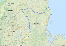
The catchment area of the Kagera |
||
| Data | ||
| location |
|
|
| River system | Nile | |
| Drain over | Victoria Nile → Albert Nile → Bahr al-Jabal → White Nile → Nile → Mediterranean | |
| source |
Rugwero Lake 2 ° 21 ′ 14 ″ S , 30 ° 21 ′ 50 ″ E |
|
| Source height | 1350 m | |
| muzzle | in Lake Victoria coordinates: 0 ° 56 ′ 40 ″ S , 31 ° 46 ′ 36 ″ E 0 ° 56 ′ 40 ″ S , 31 ° 46 ′ 36 ″ E |
|
| Mouth height | 1134 m | |
| Height difference | 216 m | |
| Bottom slope | about 0.43 ‰ | |
| length | about 500 km | |
| Catchment area | 60,000 km² | |
| Discharge at gauge Rusumo (1870800) A Eo : 30,200 km² |
NNQ (min. Month Ø) MNQ 1965–1984 MQ 1965–1984 Mq 1965–1984 MHQ 1965–1984 HHQ (max. Month Ø) |
117 m³ / s 161 m³ / s 224 m³ / s 7.4 l / (s km²) 324 m³ / s 536 m³ / s |
| Left tributaries | Kibals | |
| Right tributaries | Ruvuvu | |
|
Rusumo Falls (in front of Rwanda, opposite side of the river Tanzania). Behind the mouth of the Ruvubu (top left) into the Kagera. Direction of flow: bottom left |
||
The Kagera or Akagera belongs to the river system of the upper Nile in the area of Lake Victoria . With its headwaters, it is over 800 km long and in parts forms the border between Burundi and Rwanda , Tanzania and Rwanda and later between Tanzania and Uganda . In Rwanda, it drains Lake Rugwero at an altitude of about 1350 m on its east side ( 2 ° 21 ′ 14 ″ S , 30 ° 21 ′ 50 ″ E ) and is the source river of the Nile which is furthest away from its confluence with the Mediterranean .
course
The Kagera leaves Lake Rugwero directly at the mouth of the Nyabarongo and is connected to it by estuary arms. It flows first in a south-easterly and then in an easterly direction and forms the border between Burundi and Rwanda. Shortly after switching to the border between Rwanda and Tanzania, he picks up the Ruvubu from the southwest and then turns north. About 500 meters further north, at the point where an important paved road with border posts crosses the border between the two countries, the terrain drops 15 meters deep and forms the Rusumo Falls . This waterfall is part of Akagera National Park , which was established in 1934 and forms one of the largest protected areas along the Nile. A 110 km long and two and a half meter high electric fence, which should be completed by the Rwanda Development Board by March 2013, is intended to prevent conflicts between the wildlife in the park and the population of the adjacent areas.
With the border change between Rwanda and Uganda, the river turns east. Where the meandering demarcation between the two countries changes into a latitude , the Kagera flows through Tanzania for more than 100 kilometers before turning north, completely crossing the border to Uganda and reaching Lake Victoria after around 30 kilometers.
The Kagera is the most important tributary of Lake Victoria with around 28 percent of the total water inflow.
Hydrometry
The Kagera is by far the most water-rich Lake Victoria tributary. Its outflow makes up about a third of all the lake's tributaries. The next largest tributary is the Kenyan Nzoia with about 15%.
Average monthly flow of the Kagera (1965–1984) measured at the hydrological station in Rusumo in m³ / s.

Catchment area
The catchment area of the Kagera extends over four countries and is given as about 60,000 km².
| country | Area catchment area [km²] | Percent catchment area | Percent land area |
|---|---|---|---|
| Uganda | 5,800 | 9.7 | 2.4 |
| Rwanda | 19,900 | 33.3 | 75.6 |
| Tanzania | 20,800 | 34.8 | 2.2 |
| Burundi | 13,300 | 22.2 | 47.8 |
| Kagera as a whole | 59,800 | 100.0 |
Naming
Depending on the source, the different sections of the Kagera in Rwanda are named differently. In the German colonial lexicon and other sources, it already gets its name at the confluence of the Akanyaru and the Nyabarongo. Further on, the Nyabarongo flows into the Rugwero Lake and leaves it as Kagera.
Web links
Individual evidence
- ^ A b The Identification of Hydrological Unites in the Nile Basin
- ↑ a b GRDC - The Kagera in Rusumo
- ↑ James Karuhanga: Rwanda: Completion of Akagera Fence Pushed to March . On: allafrica.com January 17, 2013; last accessed on May 8, 2014.
- ^ Regional Transboundary Diagnostic Analysis of the Lake Victoria Basin
- ^ A b Water Resources Conflict Management of Nyabarongo River and Kagera River Watershed in Africa
- ↑ Search term Kagera in the German colonial dictionary


