
Saladin Citadel

The Citadel of Saladin (Salah ad-Din) ( Arabic قلعة صلاح الدين Qalaʿat Salāḥ ad-Dīn ) is one of the few preserved fortified structures in the city of Cairo and at the same time one of its most striking sights. It is located on a hill, in an east-south-east direction from the city center.
The Citadel plant belongs since 1979 as part of the Historic Cairo for World Heritage Site .
The citadel has only been open to the public for about 20 years. From the citadel you can enjoy a wide view over Cairo. When the weather is clear, the pyramids of Giza can be seen on the horizon. The Islamic center of Cairo is just below the fortress; the Sultan Hassan Mosque and the Ibn Tulun Mosque are part of it.
The citadel complex
.jpg)
.jpg)
The construction of the citadel complex was started in 1176 by the Ayyubid king Salah al-Din in order to be able to better defend the city of Cairo against the attacks of the Crusaders . After it was completed in 1207, it was the residence of the sultans of the Mameluke period and the Ottoman pashas. The western part of the complex was used for this purpose, while the eastern part of the citadel had a military function.
Muhammad Ali Pascha (1769–1849) made the fortress his seat of government at the beginning of the 19th century - even at the time when he was politically dependent on the Ottomans . But only a few years later (1811) he declared Egypt's independence from Ottoman rule after he had all 480 Mamluk leaders assembled in the citadel murdered, whom he had invited to a feast. In the time before that, the Mamluks formed the ruling elite of Egypt. The latter was largely eliminated or driven into the surrounding countries.
Next to the Muhammad Ali Mosque, which he built on the citadel plateau, is the "Schneckenbrunnen", a well with a spiral staircase, which originally served as a castle well to supply the citadel with water. The shaft is 88 m deep; There is a ledge at a depth of 48 m, where a scoop ( sakija ) used to be used by cattle to transport the water from the depths.
Muhammad Ali Mosque (Alabaster Mosque)
An explosion in the citadel's powder store destroyed the palace in 1824 and was never rebuilt. Instead, Muhammad Ali began building a large Turkish-style mosque, which was completed by his son Sa'id Pasha in 1857. The 82 m high pin minarets are their distinguishing feature; Their model is the minarets of the Istanbul mosques designed by the builder Sinan Pascha.
You first enter a forecourt, which is surrounded by an arcade vaulted with small domes. In the middle of the courtyard is a purification well (hanafiyya) with a protruding domed roof. It is used for ritual washing before prayer.
From this courtyard you enter the interior of the mosque, the alabaster-clad walls of which have given the mosque its common name "Alabaster Mosque". A central dome (52 m high, diameter 21 m) crowns the interior, which is covered with thick carpets, four smaller domes in the corners and four semi-domes over the sides complete this.
The oil lamps that were originally used for lighting are now in the museum and have been replaced by electric lights - they hang down in a circle from the dome and give the whole thing a weightless impression.
Inside the mosque there are two richly decorated pulpits ( minbar ). Next to the large (older) pulpit there is a smaller one, which stands further in the direction of the mihrab , the prayer niche. The prayer room was enlarged considerably, because no believer is allowed to kneel down behind the prayer leader.
The 28 m high clock tower of the Alabaster Mosque is a gift from the French King Louis Philippe to Muhammad Ali, who in turn gave Louis Philippe the obelisk that is now on Place de la Concorde .
Other special features of the citadel complex
The Citadel Hill (of the Mukattam hill area ) is missing a section; and there is a possibility that it was at times used as a quarry by the pharaohs , perhaps to extract sandstone for the construction of the great pyramids of Giza.
The citadel also contains other mosques, including the Al-Nasir Muhammad Ibn Qalawun Mosque , the Al-Gawhara Palace , the Military Museum and the Police Museum.
Visual impressions
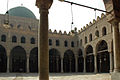
Inner courtyard view of the Al-Nasir Muhammad Ibn Qalawun Mosque, also part of the citadel complex
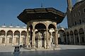
A well house in the courtyard of the Muhammad Ali Mosque

The Muhammad Ali Pasha Mosque, built on the area of the Citadel of Cairo

.jpg)

See also
literature
- Emma Brunner-Traut: Egypt, art and travel guide with regional studies . Kohlhammer, Stuttgart / Berlin / Cologne / Mainz, 6th edition 1988. ISBN 3-17-010192-7 .
Web links
Individual evidence
- ^ Historic Cairo. whc.unesco.org, accessed April 26, 2015 (ID 89-002: Mosque of Ahmed Ibn Tulun, The Citadel Area, The Fatimid Nucleus of Cairo, Necropolis ).
- ^ A b Emma Brunner-Traut: Egypt . S. 390 .
- ↑ a b c d e Emma Brunner-Traut: Egypt . S. 393 .
- ↑ a b c d Emma Brunner-Traut: Egypt . S. 391 .
Coordinates: 30 ° 1 ′ 46 ″ N , 31 ° 15 ′ 41 ″ E