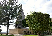
Nilometer from Roda
The Nilometer of Roda is considered bedeutendster nilometer from Islamic times and was under the aegis of the Umayyad Sulaiman Ibn Abd al-Malik 715 / 716 on the southern tip of the island of Roda in Cairo built. After being destroyed by a flood, the Abbasid caliph al-Mutawakkil rebuilt it in 861 .
A nilometer is a water level meter. In ancient Egypt, nilometers were mainly used to determine the best time for the next sowing to be carried out during the flood period, the so-called Nile flood , via the height of the water level, because after the water had receded around September to October, the flooded area was unusually fertile black Schlick stayed behind. At the same time, certain brands of high and low water levels made it possible to warn of expected famine in good time . The ability to predict the volume of the coming flood was part of the mysticism of the ancient Egyptian priesthood.
Nilometers existed in the Cairo area as early as 715; continuous time series of water levels have been handed down from 622 onwards. One nilometer was probably on the western side of the Nile opposite old Cairo, near the island of Roda; another was in operation in a Roman fort on the east bank until the Arab conquest of the city in 640.
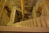
The simplest construction design is a vertical column immersed in the river. Evenly spaced marks or notches indicate the depth of the water. The Nilometer on the island of Rhoda in the center of Cairo follows this construction principle, albeit housed in an elaborate and ornate stone building.
The building consists of a square shaft in the upper part and a round shaft in the lower part, in the middle of which there used to be a column and today a pillar rises up, which is supported by a beam at the top. This pillar bore the markings for the Nilstand. A staircase leads down the side walls, which the architect Ahmad Ibn Muhammad al-Chasib has artistically decorated with Koran inscriptions . The shaft was connected to the Nile by a horizontal canal, which had to be regularly cleared of mud.
While Coptic Christians held the office of qayas (level keeper) for many years after the Islamic conquest of Egypt , the office was given to a Muslim named Abdallah Ibn ar-Raddad in the new building , in whose family the office was inherited into the 20th century .
In addition to the maintenance of the building and the regular cleaning of the canal, the main duty of the qaya was reading the nilometer. After the state of the Nile had first been publicly announced, the Fatimid caliph al-Mu'izz banned this practice in 973 out of fear of unrest. The level keeper now only reported to the caliph and the vizier . Only when the flood of the Nile had reached a height at which there was no longer any fear of famine was a public announcement made. This was to prevent hamster purchases and price increases that would occur if the Nile flood threatened to fall too low.
Ceremonial celebrations began when the Nile flood reached 16 cubits . On this day the caliph went to the Nilometer in solemn procession and said prayer at the shaft. Then he mixed saffron and musk with his own hands , with which the level keeper now lowered himself into the shaft and anointed the column.
On the following day, the caliph in the palace gave the level keeper a garment of honor with gold interlacing and, accompanied by drummers, trumpeters and his entire clan, went back through Cairo to the Nilometer.
See also
literature
- Heinz Halm : The Caliphs of Cairo. The Fatimids in Egypt 973-1074 . Beck, Munich 2003, ISBN 3-406-48654-1 , p. 54ff.
Web links
- Nilometer von Roda in Description de l'Égypte, Etat Moderne Vol. I - Île de Roudah - Pl. 23 (reference: 2_5_06.jpg). Digitized at description-egypte.org
- Jacques-Marie Le Père: Mémoire sur la Vallée du Nil et le Nilomètre de L'île de Roudah. In: Description de l'Égypte. 2nd edition, 18th volume, État Moderne , Panckoucke, Paris 1826, p. 555 ff. ( Seconde Partie. Des Meqyâs ou nilomètres. P. 595 ff .; Du Meqyâs de Roudah. Pp. 602–645); Digitized on google books (PDF; 65.6 KB).
Individual evidence
- ↑ William Popper: The Cairo Nilometer - Studies in Ibn Taghrî Birdi's Chronicles of Egypt I . University of California Press, Berkeley / Los Angeles 1951, section “Nilometers in the Cairo Area”.
Coordinates: 30 ° 0 ′ 24.8 ″ N , 31 ° 13 ′ 30 ″ E


