Entebbe
| map | |
|---|---|

Location of Entebbe within Uganda |
|
| Basic data | |
| District | Wakiso |
| Geographical location | 0 ° 4 ′ N , 32 ° 27 ′ E |
| population | 70,219 (2014) |
| medium height | 1133 m |
| Precipitation | 2000 - 2009: 1037.07 mm / a |
| Time zone | UTC +3 |
| UN / LOCODE | UG EBB |
| Telephone code | (+256) 041 |
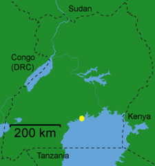
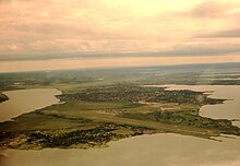
Entebbe is the former capital of Uganda . The city in the district of Wakiso with about 70,000 inhabitants is located about 35 km from today's capital Kampala on a peninsula in Lake Victoria .
Entebbe, whose name means seat in Luganda , used to be the place where a Baganda leader decided legal disputes.
In 1893 the British colonial administrator Sir Gerald Portal moved his administrative headquarters to Entebbe. From 1894 to 1962 the city was the administrative seat of Uganda. Even today there are some ministries - for example for health, for immigration and for work.
Entebbe is home to Entebbe International Airport , Uganda's international airport. The Israeli army carried out Operation Entebbe here in 1976 , when kidnappers, with the help of the Ugandan government of Idi Amins, captured an Air France plane in order to force the freedom of several imprisoned PLO members.
Entebbe has a pier on Lake Victoria with a fishing port under construction. Since Port Bell was used as the port of Kampala, no ships have moored here. The city has a botanical garden and a zoo . Outdoor shots of the Tarzan films with Johnny Weissmüller were shot in the city's botanical garden in the 1930s .
Population development
| year | Residents |
|---|---|
| 1911 census | |
| 1921 census | |
| 1931 census | |
| 1940 census | |
| 1959 census | 11,500 |
| 1969 census | |
| 1980 census | 21,289 |
| 1991 census | 42,763 |
| 2002 census | 55,086 |
| 2014 census | 69,430 |
climate
Entebbe is by far the rainiest place in Uganda, which is due to the fact that thunderstorm clusters that have formed over Lake Victoria also rain down on Lake Victoria and only move relatively rarely overland. In Entebbe, rain is almost always accompanied by thunderstorms. April 2001, the rainiest year of the decade with 1615.95 mm, brought 25 days of lightning and thunder, which was a great burden for the nearby airport. In the middle of the decade, rainfall subsided sharply. The year 2003/2004, which consisted of 2 × 6 measurement months, only had an impact of 464.57 mm. In 2005 the value was barely higher at just 471.17 mm. The average for the decade from 2000 to 2009 was 1037.07 mm per year. The heaviest torrential rain fell on March 9, 2001 with 124.95 liters per square meter and thus clearly undercut the peak values of March 22, 1995 with 382.02 mm and of September 2, 1995 with 202.95 mm. 1995 was 1915.20 mm, the wettest year since rain measurements began. Nevertheless, the nationwide drought of 1999 pushed the average for the measurement period 1993 to 1999 down to 845.04 mm per year. The maximum humidity of 100% has been reached several times in Entebbe since the 1990s.
A continuous increase in precipitation has been observed since the 1970s. The 1973 drought year reduced the annual average for the 1973 to 1978 measurement period to just 709.91 mm. Extreme temperatures such as 36 ° C on September 10, 1974 or 7 ° C on August 28, 1973 have not yet been measured again.
| Entebbe | ||||||||||||||||||||||||||||||||||||||||||||||||
|---|---|---|---|---|---|---|---|---|---|---|---|---|---|---|---|---|---|---|---|---|---|---|---|---|---|---|---|---|---|---|---|---|---|---|---|---|---|---|---|---|---|---|---|---|---|---|---|---|
| Climate diagram | ||||||||||||||||||||||||||||||||||||||||||||||||
| ||||||||||||||||||||||||||||||||||||||||||||||||
|
Average monthly temperatures and rainfall for Entebbe
Source: wetterkontor.de
|
|||||||||||||||||||||||||||||||||||||||||||||||||||||||||||||||||||||||||||||||||||||||||||||||||||||||||||||||||||||||||||||||||||||||||||||||||||||||||||||||||||||
Web links
Individual evidence
- ↑ National Population and Housing Census 2014 - Area Specific Profiles: Wakiso District ubos.org. Accessed July 2, 2018


