
Kiwu Lake
| Kiwu Lake | |
|---|---|

|
|
| Lakeshore in Rwanda | |
| Geographical location |
East Africa DR Congo , Rwanda |
| Tributaries | Kalundura |
| Drain | Ruzizi |
| Places on the shore | Gisenyi , Goma , Kibuye , Cyangugu , Bukavu |
| Data | |
| Coordinates | 1 ° 48 ′ S , 29 ° 10 ′ E |
 |
|
| Altitude above sea level | 1461 m |
| surface | 2401 km² |
| length | 89 km |
| width | 48 km |
| volume | 500 km³ |
| Maximum depth | 480 m |
| Middle deep | 237 m |
|
particularities |
Large amounts of trapped carbon dioxide, methane and hydrogen sulfide in water depths below 180 m. |

|
|
| View of Lake Kiwu from space | |
The Lake Kivu or Lake Kivu is a lake in Central Africa . The border between Rwanda and the Democratic Republic of the Congo runs through it .
geography
,_Photo_by_Sascha_Grabow.jpg)
Directly east of the great Central African threshold and west of the Rwanda highlands, it lies south of the Virunga volcanoes and north of the provincial capital Bukavu . The lake lies in the East African Rift Valley .
One of the tributaries that feed Lake Kivu is the Kalundura , which plunges down from the highlands mentioned above. The lake is drained in the south via the Rusizi into Lake Tanganyika .
The Kiwu Lake has an area of approx. 2400 km² and it is up to 480 m deep.
The most important island is Idjiwi , which belongs to the Democratic Republic of the Congo. The island of Iwawa is located in Rwanda and is closed to the public as a military area.
history
The Kiwu Lake was first explored by Gustav Adolf von Götzen in 1894. Then several travelers were busy researching the geographic and natural history:
- 1898/1899: Ewart Grogan and Arthur H. Sharp , northern half
- 1899: Heinrich von Bethe
- 1899/1902: Richard Kandt
- 1899/1900: Moore and Fergusson and Robert von Beringe
- 1900: Gibbons
- 1901/1902: Herrmann
At the beginning of the First World War in East Africa , the German Schutztruppe briefly gained sea sovereignty and occupied the island of Idjiwi. In the course of the war she was pushed to the southeast by Belgian colonial troops from the Congo .
The methane lake Kivu Lacus on Saturn's moon Titan is named after the lake .
Fish fauna
Lake Kivu is comparatively poor in species and is populated by only around 35 species of fish. The largest part of the fish fauna of Lake Kivu is made up of 15 endemic Haplochromis species ( H. adolphifrederici , H. astatodon , H. crebridens , H. gracilior , H. graueri , H. insidiae , H. kamiranzovu , H. microchrysomelas , H. nigroides , H. occultidens , H. olivaceus , H. paucidens , H. rubescens , H. scheffersi and H. vittatus ). More living in the lake fish species, the cichlids Oreochromis mweruensis and O. niloticus eduardianus that carp labeobarbus altianalis , Enteromius apleurogramma , E. kerstenii , E. pellegrini and raiamas moorii , and the catfish Amphilius uranoscopus , Clarias gariepinus , Clarias liocephalus and Chiloglanis batesii . The occurrence of Schilbe grenfelli is questionable. Oreochromis leucostictus , O. macrochir , O. niloticus niloticus , Coptodon rendalli and the Lake Tanganyika sardine ( Limnothrissa miodon ) were introduced by humans .

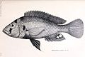
Haplochromis adolphifrederici
Haplochromis graueri


Geological and climatic conditions
What makes Lake Kiwu unique is the fact that both the water temperature and the salinity increase with increasing depth. The cause of this phenomenon are volcanic springs from the underground. In addition, there are no major seasonal temperature fluctuations in this region; permanent cooling of the water layers close to the surface is not possible; the sinking of colder surface water into the depths - and thus water exchange - is largely excluded.
Saturation with gases
The Kiwu Lake has very high concentrations of dissolved gases in its deep water. Due to the high water pressure, the layers only mix very little at great depths; from a depth of 180 m, the layers remain for a long time of up to 1000 years. It is estimated that about 225 km³ of carbon dioxide (CO 2 ) and together about 75 km³ of methane (CH 4 ) and hydrogen sulphide (H 2 S) are dissolved in the lake (volume data of the gases in relaxed state). This is only possible due to the high pressure at a depth of over 250 m. The saturation is currently (as of 2016) around 55% of the maximum saturation in the deep layers. In recent years, however, a significant increase in methane levels compared to the 1970s has been noted , presumably due to eutrophication . If, with a constant increase, the total saturation in the depth reaches 100% by the end of the 21st century, this could lead to a dangerous gas outbreak in which, similar to 1986 at Lake Nyos in Cameroon or 1984 at Lake Manoun , people in the Around the lake could suffocate. Around two million people are currently at risk here.
The last eruption of the nearby Nyiragongo volcano in 2002 feared such a catastrophe, as it was suspected that sudden emissions could also be triggered by volcanic activity. However, no outgassing was found.
Use of methane
In order to avert the risk of a gas outbreak and at the same time to use the enormous and apparently renewable methane supply, a project is currently being pushed ahead that will pump out small amounts of the gaseous water and use the methane to operate a 70 megawatt power plant. Approx. Four kilometers from the lake shore, the “Kibuye I” production platform with a 25 m high tower was built in 2009/2010 not far from the city of Gisenyi. The water containing CO 2 and methane is sucked in from a depth of 320 meters using powerful mammoth pumps . A gas separator cascade is installed in the suction line hanging freely in the lake, by means of which CO 2 and methane are separated from the water and from each other. Approximately 1000 m³ of methane gas per hour are to be transported through a pipeline to a power plant. In the vicinity of Gisenyi, three generators with an output power of 30 MW are producing the basic electricity requirements for the city and the Bralirwa brewery. Further, considerably larger-sized systems of this type with cross-border power supply mandates are in the planning stage. In April 2011, the World Bank's Multilateral Investment Guarantee Agency (MIGA) secured a $ 142 million methane gas power generation project for the US company ContourGlobal .
See also
literature
- Jean-Pierre Descy, François Darchambeau, Martin Schmid (eds.): Lake Kivu. Limnology and biogeochemistry of a tropical great lake (Aquatic ecology series; Vol. 5). Springer, Dordrecht 2012, ISBN 978-94-007-4242-0 .
swell
- ↑ Reinhard K. Lochner: Battle in the Rufiji Delta . Munich 1987, p. 294ff. ISBN 3-453-02420-6
- ↑ J Snoeks, De Vos, L., Thys van den Audenaerde, D .: The ichthyogeography of lake Kivu . In: South African Journal of Science . 93, 1997, pp. 579-584. ( PDF ).
- ↑ Fishbase Species in Kivu
- ^ KT Whittaker, TC Johnson, AI Johnson, JI Johnson (1996). Limnology, Climatology and Paleoclimatology of the East African Lakes . ISBN 2-88449-234-8
- ↑ Klaus Sieg: Pearly Time Bomb . In: VDI news . 12/13, 2018, pp. 10-11.
- ↑ Eawag -News 62 (2006). Dangerous gas masses in the depths of Lake Kivu ( Memento from August 12, 2014 in the Internet Archive ) (PDF; 493 kB)
- ↑ Risks of a gas outbreak
- ↑ NZZ Online: ETH researchers help find a solution for Lake Kivu . October 11, 2007
- ↑ project page, Michel Halbwachs with further detailed information
- ↑ a b Horand Knaup: Zukunft aus dem See , in: Der Spiegel 35/2010 of August 30, 2010, p. 110, accessed on May 23, 2018.
- ↑ a b Günther Beyer, Gabi Mayr: Der Schatz im Kivu-See , in Süddeutsche Zeitung of June 30, 2011, p. 16, accessed on May 23, 2018.
Web links
- Lake Kivu in Africa - The dangerous hunt for methane treasure , Spiegel Online - Article from September 3, 2010.
- Killer Lakes - Silent Death from the Deep , Spiegel article from March 8, 2008.
- Time bomb under water , Süddeutsche Zeitung, May 31, 2007 (PDF file; 42 kB)
- Lake Kivu in Rwanda and DR Congo