Sobat
| Sobat | ||
|
The Sobat river system |
||
| Data | ||
| location |
|
|
| River system | Nile | |
| Drain over | White Nile → Nile → Mediterranean | |
| source | the rivers Pibor and Baro 8 ° 26 ′ 6 ″ N , 33 ° 13 ′ 9 ″ E |
|
| Source height | 404 m | |
| muzzle |
White Nile Coordinates: 9 ° 22 '2 " N , 31 ° 32' 57" E 9 ° 22 '2 " N , 31 ° 32' 57" E |
|
| Mouth height | 394 m | |
| Height difference | 10 m | |
| Bottom slope | 0.01 ‰ | |
| length | 740 km | |
| Catchment area | 246,779 km² | |
| Outflow at the gauge Doleib Hill A Eo : 230,666 km² Location: 8 km above the mouth |
MNQ 1905-1983 MQ 1905-1983 Mq 1905-1983 MHQ 1905-1983 |
88 m³ / s 429 m³ / s 1.9 l / (s km²) 758 m³ / s |
| Left tributaries | Nyanding , Thui | |
| Big cities | Malacal | |
| Medium-sized cities | Abwong , Wunagak | |
| Navigable | in the flood season | |
|
Sobat |
||
The Sobat is an approximately 350 km long tributary of the White Nile in South Sudan .
geography
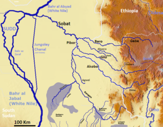
With its longest source river, the Sobat reaches a length of about 740 km. The catchment area is given with values between 225,000 and 247,000 km² (occasionally over 430,000 km²). Its headwaters are in the Ethiopian highlands in southwest Ethiopia and are often referred to as the Baro – Akobo river basin. Most of the water comes from the Baro , which becomes Sobat after the confluence with the Pibor on the border between Ethiopia and South Sudan .
The main tributary in Ethiopia is also called Baro Wenz, the mouth of the Pibor is called Nahr Baru. The Sobat flows in a north-westerly direction through South Sudan and flows into the White Nile south-east of Malakal at Doleib Hill . It is navigable up the Baro to Gambela in Ethiopia during the flood season . The largest place on Sobat is Nasir . The Nyanding and Thui are to be mentioned as left tributaries .
Hydrometry
After the main summer rainy season in the Ethiopian highlands, the Sobat leads the White Nile (Bahr el Abiad) with around 7.45 billion m³, around 55% of its annual runoff (13.5 billion m³) in the months of September to December alone.
Average monthly flow of the Sobat measured at the hydrological station of Doleib Hill, about 8 km above the mouth in m³ / s (1905–1983).

The Pibor brings only a good 30 m³ / s of water to the Sobat from the south until shortly before the mouth of the Akobo , a tributary of the Pibor. However, only a few kilometers further east from the Ethiopian highlands, the Akabo already drains almost 90 m³ / s. Accordingly, a good 100 m³ / s flow at the confluence with the Baro, which is about 80 km further in arid and technical areas. In addition there is the runoff of the river Gilo with a further 100 m³ / s. The Baro, also coming from the east, has the highest discharge of 300 m³ / s at the confluence.
Conflicts
The river is the most important transport link for many villages. At the beginning of June 2009, an armed group of the local Jikani- Nuer attacked 27 boats in convoy, which were escorted by SPLA soldiers and were supposed to transport food aid from the WFP from Nasir to Akobo. There were dead and wounded. In the months before, there were several armed clashes between the hostile Nuer ethnic groups Lou and Jikani. The traditional cause of the shootings was revenge from cattle theft.
Individual evidence
- ^ A b FAO - Information Products for Nile Basin Water Resources Management
- ^ A b The Hydrology of the Nile
- ↑ Ministry of Electricity, Dams, Irrigation & Water Resources (Mediwr) the Republic of South Sudan - Project for Irrigation Development Master Plan (Idmp) in the Republic of South Sudan, Final Report (Main)
- ^ The Nile River (page 9). (No longer available online.) Archived from the original on December 3, 2011 ; Retrieved December 24, 2011 . Info: The archive link was inserted automatically and has not yet been checked. Please check the original and archive link according to the instructions and then remove this notice.
- ↑ Estimation of Monthly Flow for Ungauged Catchment (Case Study Baro - Akobo basin)
- ^ Hydrologic Regime in the Nile Basin - Mean annual flow of the Nile and main tributaries upstream of Lake Nasser
- ↑ Sudan gunmen attack food barges. BBC, June 14, 2009
- ^ Gunfire raises tensions after south Sudan killings. Reuters India, June 16, 2009

