Gilo (river)
| Gilo | ||
|
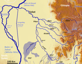
The Gilo in the Sobat River System (middle right) |
||
| Data | ||
| location |
|
|
| River system | Nile | |
| Drain over | Pibor → Sobat → White Nile → Nile → Mediterranean | |
| confluence | of the two rivers Godare and Beko | |
| muzzle | in the Pibor coordinates: 8 ° 8 ′ 30 " N , 33 ° 11 ′ 32" E 8 ° 8 ′ 30 " N , 33 ° 11 ′ 32" E |
|
| Mouth height |
406 m
|
|
| Catchment area | 12,815 km² | |
| Outflow A Eo : 12,815 km² at the mouth |
MQ Mq |
102 m³ / s 8 l / (s km²) |
| Discharge at the gauge Pugnido (102006) A Eo : 10,137 km² |
MNQ 1967-1993 MQ 1967-1993 Mq 1967-1993 MHQ 1967-1993 |
25.6 106 m³ / s 10.5 l / (s km²) 200 m³ / s |
| Left tributaries | Uses | |
| Communities | Funyido | |
The Gilo is a river in southwest Ethiopia .
course
The Gilo gets its water from the Ethiopian highlands. It arises from the confluence of the two source rivers Godare and Beko, which unite in the Gambela region . The Gilo flows in a north-west-west direction. It flows into the Pibor on the border with South Sudan , about 40 km before it joins the Baro to form Sobat .
Hydrometry
The flow rate of the river was measured for 26 years (1967–1993) at the Pugnido gauge in m³ / s.

