
Lake Chad
| Lake Chad | ||
|---|---|---|

|
||
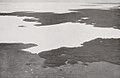
| Satellite imagery of Lake Chad. Above: 1973, 1987 and 1997. Large picture: 2001 ( false color photography , blue water, green vegetation) | ||
| Geographical location | Central Africa | |
| Tributaries | Komadugu Yobe , Shari | |
| Drain | drainless | |
| Places on the shore | N'Guigmi | |
| Data | ||
| Coordinates | 13 ° 5 ′ 0 ″ N , 14 ° 30 ′ 0 ″ E | |
|
||
| Altitude above sea level | 280 m | |
| surface | 1,500 km² | |
| Maximum depth | 7 m | |
| Middle deep | 2 m | |
|
particularities |
flat, annually changing shorelines |
|

|
||
| Map from 1973 | ||

The Lake Chad is an endorheic lake in West - Central Africa . It is located on the southern edge of the Sahara in the Chad Basin and is divided between the states of Chad , Cameroon , Nigeria and Niger . There are two triangles in the lake: Cameroon-Chad-Nigeria in the southeastern part and Niger-Chad-Nigeria in the northwestern part. Both are no longer covered by the water surface of the lake, the remaining water surface is distributed between Chad and Cameroon.
The lake has come into the public eye in recent decades due to a dramatic drop in the water level , as the adjacent satellite images show; its area has shrunk by more than 90% since 1963, which is also seen as a result of global warming . However, these old reports on the contraction process have recently been critically questioned by scientists and in some cases refuted.
The lake has always had variable shorelines and water volumes: around 1450, for example, the southern basin of the lake dried up, which was due to a shift in its main tributary and which led to a flood disaster in the years that followed. During the colonial days of the region, officials said they faced changing shorelines of the lake from year to year. One year they were able to cross areas of the lake bed dry-footed, the following year they had to use a boat for the same route. The current lake volume is generally given as 73 km³.
geography
Lake Chad is one of the world's largest endorheic freshwater bodies , which, due to its location on the edge of the Erg Kanem desert, creates a unique and globally significant ecosystem . It is known as the large, normal and small Lake Chad due to its historically verifiable different water levels over the last thousand years.
- From the big Lake Chad is when the free water surface of over 24,000 square kilometers covered (level over 284.2 meters above sea level).
- The normal Lake Chad covers an area of 18,000 to 22,000 km² (level 279 to 282 meters above sea level).
- From the small Lake Chad is when the free water surface 2000-14000 is km² (level then 278.5 meters above sea level).
Below the mark of 2000 km², the then remaining Lake Chad has the characteristics of a very large wetland .
The lake basin of the normal Lake Chad is divided into a northern and a southern basin, which are separated by the old dune zone of the Great Barrier and Grande Barriêre, so hydrochemical exchange processes can only take place at water levels above 280 meters. The fourth geographic sector of the normal Lake Chad is called the Archipelago, it is located in the northeast of the eastern bulge of the lake. The northern lake basin has a depth of seven meters, the southern a depth of three to four meters. In the eastern part of the southern lake basin, the valley of the Bahr el-Ghazal wadi joins, this forms an overflow channel of the lake, leading to the deepest depression in the Chad basin, the Bodélé Depression . This is flooded from a level of 13 meters above the lake bed, the last time it happened in 1962 and 1964, when the water penetrated 50 km into the Bahr el Ghazal.
The regression of the lake that has been observed since the 1970s culminated in the late 1990s. The areas that are no longer continuously covered by the open water surface of the lake now form a large wetland area, which is referred to by the WWF as the Lake Chad flood savannah. This area has been under the protection of the Ramsar Convention since 2008 as the Lake Chad Wetlands , the largest extent of which is in Nigeria, where it is known as the Lake Chad Game Reserve . It is the first protected transboundary wetland of international importance on the African continent.
history
The history of Lake Chad is closely linked to the climatic conditions of the region, but also reflects the climatic history of the entire earth. Thus, an expansion of the lake of almost 2 million km² could be determined about 50,000 years ago. It extended from the Tibesti and Ennedi Mountains to the Central African Threshold . The lake dried up completely in the age of Ogolia or Kanemien until about 22,000 years ago, which was to last until about 12,000 years ago. Then the humid phase of the first Nigéro-Chad began, in which the lake reached a depth of 15 meters before it dried up again 11,000 years ago. In Nigéro-Chadia II, 9000 years ago, the lake was able to regenerate and reached a water depth of 38 meters before it was reduced to a size comparable to that of today.

The largest expansion so far during the era of the Nigéro-Tschadien reached the lake including the significantly deeper Bodélé Depression as Mega-Chad between 6000 and 4000 years before today. It reached an average water depth of about 65 meters and an area of about 360,000 km². The outflow from Mega Chad took place at around 325 meters above sea level southwest of the town of Bongor on the Logone . Over the Mayo Kébbi , the excess lake water spilled into the Benue and Niger and thus had a connection to the Atlantic. The isolated occurrence of African manatees in the tributaries of Lake Chad proves this connection.
After this maximum expansion, its water surface was reduced to 60,000 km² 2000 years ago and 36,000 km² 1000 years ago. Lake Chad reached its smallest recordable size in 1908 when it dried up except for a few wetlands in the northern and southern basins. It then regenerated to a size of 22,900 to 25,000 km² in 1963. In the early 1970s, a series of dry spells began, in which the lake continued to shrink, up to a maximum of 4,000 km² in 2001. In 2008 it had a minimum Expansion of 30 x 40 km at the mouth of the Shari, which corresponds to an open water area of 2500 km².
Hydrology
The water catchment area of Lake Chad has a size of about 967,000 km² and is referred to by the Lake Chad Basin Commission as a conventional basin. The lake gets between 80 to 90 percent of its water from the tributaries of the Shari (French: Chari) and the Logone, which flows into the Shari at N'Djamena . Less than ten percent of the inflow comes from Nigerian rivers and local rainfall. First and foremost, these are the Komadugu Yobe and the El Beid . The Ngadda and Yedseram are of lesser importance , but most Nigerian rivers, with the exception of the El Beid, have not reached the open water areas of the small Lake Chad since the great dry spells of the 1960s to 1980s. All of these rivers carry water all year round , but are subject to seasonal fluctuations in level. The regional precipitation falls in the months of June to September. They are controlled by the intensity of the West African monsoon system . Only between 250 and 450 mm of precipitation fall per year in the Lake Chad region. The lake is generally described as a typical representative of the freshwater lakes of the Sahel, which are characterized by their very low salinity .
Thus, the water balance of Lake Chad is very much dependent on the precipitation in the shared catchment area of Shari and Logone, around 800 km away. In the rhythm of the rainy seasons, the water level of the lake fluctuates and floods kilometers of flat land or retreats accordingly. Given the shallow depth (in large areas of the lake it is less than one meter, at the deepest points hardly more than five) and the high rate of evaporation, its banks are constantly shifting. The average evaporation rate differs regionally, in the southern lake basin it is approx. 2022 mm / year, in the archipelago area 1952 mm / year and in the northern lake basin approx. 2365 mm / year for the period from 1900 to 2010. These high evaporation rates make Approx. 95% of the lake's natural water loss, the remaining 5% seep into the lake floor and fill up the regional aquifers
Due to the growing population, there was also increased use and withdrawal of water from the lake and its tributaries (drinking water, agriculture). When the average annual water volume carried by the Shari was reduced from 42 km³ in the period 1954–1969 to 21.1 km³ in the period 1988–2010, its average surface area covered by water decreased drastically. The regression even took on dramatic proportions as a result of the drought in the 1970s. The northern lake basin dried up completely; a small body of water remained in the south. Nigeria completely lost its share of the open water surface. New settlements on dry lake bed emerged in all of the above-mentioned states, as the areas that are freed up are very fertile and can therefore be used for agriculture. In some cases they had to be partly given up again after the shorelines of the shallow water areas shifted in opposite directions due to increased precipitation. It is uncertain whether this transgression, which has been observed since 1998, will continue in the future. What is to be feared, however, is the increasing drying up of Lake Tashad due to fluctuations in precipitation / decrease in precipitation due to climate change. There are considerations to supply water from the Ubangi, which flows into the Congo, via a canal to the Chari and thus to Lake Chad. These plans are viewed critically by environmental protection organizations (displacement of native animal and plant species).
ecology
In order to understand the ecology of the current Lake Chad, it is appropriate to consider the lake with its very changeable coastlines. Its water level fluctuates not only with the seasons , but also between the years. The period of low water is in the months of May / June. With the arrival of the summer monsoons, the lake begins to expand. The flood season in its tributaries reach the lake in October / November, so that the lake reaches its water maximum in December / January, only to shrink again afterwards. The lake floods an area several thousand square kilometers each year. In 1998 the minimum size of the lake was around 1750 km², but its maximum size was around 6000 km². In 2001 the water surface fluctuated between 4000 km² and 19,000 km². The water cover in the northern basin depends mainly on the tributaries of the Komadugu Yobe and Ngadda; this has an approximate volume of 0.5 to 0.8 km³ per year. In water-rich years the water cover can be up to 6000 km², but in arid years it is dry. From this hydro - and ecological point of view, the term lake near Lake Chad is sometimes misleading. It is more appropriate to regard Lake Chad as a wetland, since on the one hand the depth of the free water surface is on average only one to three meters. On the other hand, large parts of the normal Lake Chad are covered with islands and sedge islands . This area, called archipelago, accounts for about 62% of the total area of normal Lake Chad, the free water surface is only 38%. For this reason, Lake Chad is referred to by WWF as the Lake Chad Flooded Savanna ecoregion (Eng .: Lake Chad wetlands). The extension of this ecoregion is about 19,000 km² and includes the geographically separated Hadejia-Nguru wetlands . Another special feature of the lake is the rather long four to five month flood season in its tributaries. This long flood season results from the four to six month monsoon season in the headwaters and the extensive wetlands of the Schari / Logone / El Beid river system. These wetlands in the Massenya Plain , the Bahr Aouk / Salamat Plain , the Logone Plain / Toupouri Depression and the Grand Yaeres have a combined area of around 80,000 to 90,000 km². They absorb a large part of the monsoon precipitation on the upper reaches of the rivers, but only release them slowly. The ecology of the wetlands contributes to the abundance of algae in Lake Chad. The flooding and drying of the plains create ideal conditions for the growth of algae , zoo and phytoplankton , of which more than 1000 species have been identified in the lake and form the basis of food for the diverse fish fauna.
Flora and fauna
The information about the fish fauna is very different, the Lake Chad Basin Commission indicates 176 fish species living in the lake. To those found in the Lake Chad fish species include the African arowana ( Heterotis niloticus ), the carp fish coubie Labeo that Geradsalmlerarten Citharinus citharus and Citharinus distichodoides , various Alestes species, catfish of the genera Clarias , Schilbe and Synodontis , the Nile perch ( Lates niloticus ) Cichlids from the tilapia relationship, including Oreochromis niloticus and the puffer fish Tetraodon lineatus . The tetra subspecies Brycinus nurse dageti is endemic . However, the fish stocks in Lake Chad are considered overfished, and the annual catches depend on the water level and the extent of the lake. In the period from 1972 to 1977 annual catches of over 180,000 tons were reported. As a result of the dry periods and the sinking level of the lake, these sank to around 56,000 tons at the end of the 1980s and rose in the two following decades to around 120,000 tons / year. The fishery generates about 23 million US dollars annually and catches from the lake are also offered in the markets of Lagos and Abuja . With the expansion of agriculture in the region, however, increasing alkaline water chemistry and eutrophication are observed, which leads to algal blooms and a lack of oxygen in the lake water, which threatens the diverse lake fauna.
About 372 species of avifauna have been identified. The Lake Chad region has been designated an Important Bird Area (IBA) by BirdLife International . The wetlands of the lake are of particular importance for the migratory birds from the northern hemisphere , which use the wetlands as resting and wintering areas. In the wetlands, the ruff ( Philomachus pugnax ), the widow whistle goose ( Dendrocygna viduata ), the teal duck ( Anas querquedula ) and the pintail ( Anas acuta ) occur seasonally . Resident bird species are, for example, the Tschadpirin ( Prinia fluviatilis ), Arabian bustard ( Ardeotis arabs ), gray-headed gull ( Chroicocephalus cirrocephalus, Syn. Larus cirrocephalus ) and the white- headed goose ( Sarkidiornis melanotos ). Statistical surveys based on censuses from 1984 showed that 61,900 duck birds (Anatidae) regularly visit the Lake Chad ecoregion.
In the lake and its wetlands are, inter alia, the Nile crocodile ( Crocodylus niloticus ), Hippos ( Hippopotamus amphibius ) and spotted-necked otter ( Hydrictis maculicollis ; Syn. : Lutra maculicollis ) before, in the shore regions antelope , the Sitatunga ( Tragelaphus spekii ) African elephant ( Loxodonta africana ) and primates such as the hussar monkey ( Erythrocebus patas ) and the tantalus green monkey ( Chlorocebus tantalus ). A domesticated cattle specially adapted to the living conditions in the wetlands of Lake Chad is the Kuri cattle, whose taxonomy was a mystery in the past. According to recent genetic studies, it comes from breeding of the East African Watussi cattle and thus proves the far-reaching history of migration and the trade contacts of the Lake Chad peoples.
_-_Barca_in_papiro_dal_lago_Ciad_-_Foto_Giovanni_Dall%27Orto,_19_mar_2014.jpg)
The flora in the vegetation zone of the southern lake basin is determined by large areas covered with real papyrus ( Cyperus papyrus ), Phragmites mauritianus , Vossia cuspidata and other marsh plants. The water lettuce ( Pistia stratiotes ) swims on the open water surfaces and covers a large area of the lake. In the area of the northern lake basin, the reed ( Phragmites australis ) and the cattail Typha domingensis dominate the vegetation. The plants like papyrus are also of great economic importance. This is used by the Buduma (Yedina) to build their reed boats. Thor Heyerdahl used the knowledge of three Buduma reed boat builders to build the Ra I , which was supposed to sail 5,000 km across the Atlantic Ocean in 1969 .
The Yaérés vegetation arises seasonally in the southern shore region of the lake . This is dominated by the grasses Echinochloa pyramidalis , Vetiveria nigritana , Oryza longistaminata and Hyparrhenia rufa . The Yaéré vegetation dies in the dry season. The more humid zones of the Yaérés are known as the Karal or Firki plains . The trees in these plains are largely made up of the Seyal acacia ( Acacia seyal ) and the fragrant acacia ( Acacia nilotica ). The vegetation in this savannah consists of herbs and grasses up to 2 to 3 meters high, such as Caperonia palustris , Echinochloa colona , Hibiscus asper , Hygrophila auriculata and Schoenfeldia gracilis .
Research history on Lake Chad
Archaeologists found the oldest pottery finds in West Africa near its bank and a dugout canoe near Konduga in northeastern Nigeria , the age of which is dated to eight thousand years. The landscape surrounding the lake at that time with a more humid and cooler climate than today, a savannah criss-crossed by numerous tributaries , offered the people living there abundant food resources and was settled early. Several long-lasting regression phases and weaker transgressions can be seen on the former beach walls, which were mapped after geomorphological investigations and the evaluation of satellite photos. Beyond the wide beach wall system, the Bama and Ngelewa Beach Ridges , extensive lagoon landscapes with loamy, dark vertisoles emerged . From 1800 BC Chr. People increasingly penetrated into the former lagoon areas, where settlements were established on the flood-free sandy islands in the clay plains. On the local level of the Firki Plains southwest of the lake, the Gajiganna culture marks the beginning of the Holocene settlement after the early and middle Holocene floods of Lake Chad. The best known excavation site of this early West African culture is Zilum , which already showed protourbane features such as moats and ramparts in the late phase of the Gajiganna culture. Other archaeological sites of this culture are Kursakata, Mege and Ngala. The archaeological evidence of the Gajiganna culture are mostly simple clay figures of humans and animals as well as clay vessels with simple decorations such as imprints of woven mats. No evidence of this culture is known after the fourth century BC. With this culture the transition from a society of hunters and gatherers to food producers in the savannas of West / Central Africa could be documented.
Settlement of the Lake Chad region continued; around 2000 years ago, the first archaeological evidence of people who produced and used iron objects appeared south of Lake Chad. The Iron Age is dawning of Lake Chad from that time in this region. A well-known archaeological site of this period is Mdaga . During this period, the beginning of the Trans-Saharan trade is assumed, in which the Lake Chad region is said to have played an important terminal on the route between Tripoli , the Fessan and the Kaouar valleys . References to such a trade can be found in Herodotus and Claudius Ptolemy , the latter reports on a country Agisymba in the 2nd century, although it is still controversial today where this country was actually located. The next archaeologically verifiable culture in the Lake Chad region can be found from the sixth century AD with the appearance of the Sao culture . The Sao culture can be documented until the 17th century. The production of large urns and small terracotta figures is typical of this culture.
According to generally accepted historical research, nomadic Zaghawa migrated to what is now the Kanem region, northeast of Lake Chad, in the 7th century . They are considered to be the founders of the empire of Kanem , whose mythical founding father was Sef (Arabic: Saif), but the exact circumstances of the empire's founding are largely in the dark. According to the immigration theory of Bayreuth Dierk Lange, refugees from the Assyrian Empire, which perished in the 6th century BC, were supposed to enter the Lake Chad region around 600 BC. And have had a significant influence on the cultures of the region. According to this theory, the Assyrians are said to have been the actual founding fathers of the empire, but this theory is considered highly speculative, as no archaeological and cultural-historical evidence has been provided so far. The early Islamization of the region around the lake in 10/11 can be proven. Century, when the Sayfawa dynasty came to power in the Kanem Empire.
The first written reports about the Lake Chad region can be found in al-Yaqubi in his Kitaab al-Buldaan (Geography of the World or Book of Countries), published at the end of the 9th century , in which he reports on the country of Kanim, but without mentioning Lake Chad . Information about Lake Chad can only be found in the 11th century from Abū ʿUbaid al-Bakrī . Therefore, it is only since this time that one can clearly differentiate geographically between Kanem, east, and Bornu, west of Lake Chad. He also reports on large mosques and oases and provides information on individual ethnic groups. However, he assumes that the Niger and Lake Chad are part of the Nile river system. Another source is Ibn Saìd , a Muslim cartographer born in Granada / Spain . He reports on Lake Kuuri, which is part of the watercourse of the Nile from Ghana to Egypt. He went on to say that the Kanimis navigated the lake and that the southern lake dwellers, the Sao, do not disdain human flesh, while the Kanimis are good Muslims. Other Arabic sources are known from Al-Dimashqi (1256-1327) from Damascus and Abu'l-Fida (1273-1331), also from Damascus.
The first European mention of Lake Chad can be found in Leo Africanus , who traveled to the region in 1513 and reported on a country called Shary and the Lake of Gaoga in his work Descrittione dell'Africa . Further sources can be found in the encyclopedia L'Universale Fabrica , written by Giovanni Lorenzo Anania, who describes the Rio Negro , the Niger, and the Lago di Sauo , the Lake Chad. This work appeared in several volumes between 1571 and 1592 and served numerous cartographers as source literature for describing the region until the 19th century.
Since sub-Saharan Africa represented a kind of terra incognita for the European cultural area up to the 19th century , these are the only sources about the region of Lake Chad from the Middle Ages to the Renaissance . The first modern reports come from the German Friedrich Konrad Hornemann , who traveled to the region in 1800 on behalf of the British; further reports come from Denham , Clapperton and Oudney from the year 1822. The most famous travel reports in which Lake Chad was mentioned come from Heinrich Barth , Adolf Overweg and Gustav Nachtigal .
literature
- Jan Patrick Heiß: A little-known ethnic group. The Yedina of the Chad Islands (= working papers, Institute for Ethnology and African Studies. 65). University of Mainz, Mainz 2006, urn : nbn: de: hebis: 77-11165
- Werner Gartung: Yallah Tibesti. From Lake Chad to the rock people. Westermann, Braunschweig 1992, ISBN 3-07-509400-5 .
- AT Grove, R. Pullan: Some aspects of the Pleistocene paleogeography of the Chad Basin. In: FC Howell, F. Bourlière (eds.): African ecology and human evolution. Viking Fund Publications in Anthropology. 36, 1963, pp. 230-245.
- AT Grove, R. Pullan: Rise and Fall of Lake Chad. In: Geographical Magazine. 3, 1970, pp. 432-439.
- AT Grove: Geographical Introduction to the Sahel. Water Characteristics of the Chari system and Lake Chad. In: Geographical Journal. 144 (3), 1978, pp. 407-415.
- Walter Konrad: Zad - secret between Niger and Nile. An ethnographic contribution to the knowledge of Lake Chad islanders. In: Journal of the Museum in Hildesheim. NF, No. 9, 1955.
- Thomas Krings: Sahel countries (geography). Scientific Book Society, Darmstadt 2006, ISBN 3-534-11860-X .
- Walter Konrad: People of the grasses Studies on the Buduma (Yedina) of Lake Chad (= Borno Sahara and Sudan Studies. Studies in the Humanuties and Social Sciences University of Maiduguri ). Rüdiger Köppe Verlag, Cologne, ISBN 978-3-89645-507-9 .
- Matthias Krings, Editha Platte (ed.): Living with the Lake. (= Studies in cultural studies. No. 121). Rüdiger Köppe Verlag, Cologne 2004, ISBN 3-89645-216-9 . (English)
- Caterina Batello, Marzio Marzot, Adamou Harouna Touré: The Future is an Ancient Lake. FAO Interdepartmental Working Group on Biological Diversity for Food and Agriculture, Rome 2004, ISBN 92-5-105064-3 .
- Tsadsee . In: German Colonial Lexicon . Volume III, 1920, p. 549 f.
- Janani Vivekananda, Dr Martin Wall, Dr Florence Sylvestre, Chitra Nagarajan: Shoring up Stability - Addressing climate and fragility risks in the lake chad region . adelphi research non-profit GmbH, Berlin May 15, 2019.
Picture gallery
Aerial photo by Walter Mittelholzer , December 1930
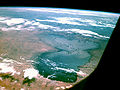
Image taken by Apollo 7 , October 1968


Web links
- Uncertain future: Lake Chad is disappearing nationalgeographic.de, November 9, 2017
- The dying lake spiegel.de, January 15, 2018
Individual evidence
- ↑ nytimes.com , April 19, 2017, Jessica Benko: How a Warming Planet Drives Human Migration (accessed April 27, 2017)
- ↑ Shoring up Stability - Addressing climate and fragility risks in the lake chad region, May 15, 2019, Shoring up Stability - Addressing climate and fragility risks in the lake chad region (accessed on April 3, 2020)
- ↑ Jacques Lemoalle, Jean-Claude Bader, Marc Leblanc The variability of Lake Chad: hydrological modeling and ecosystem services (English) (PDF format)
- ↑ Lake Chad flooded savanna (English)
- ↑ Barbara Widhalm: Analysis of spatiotemporal dynamics of wetlands in different climatic zones with ENVISAT ASAR. (PDF) Master's thesis. technical University of Vienna
- ↑ Chad . ( Memento of September 24, 2012 in the Internet Archive ) (PDF; 173 kB; p. 10) Ramsar
- ↑ Lake Chad to be fully protected as international wetlands africanconservation.org, February 2, 2010.
- ↑ Lake Chad, Managing Rivers Wisly . (PDF) WWF (English)
- ↑ Height information at OpenCycleMap
- ↑ Leblanc et al. 2006 Reconstruction of megalake Chad using shuttle radar topographic mission data. Palaeogeography, palaeoclimatology, palaeoecology 239, pp. 16-27 ISSN 0031-0182 1872-616X
- ↑ History of the Lake Chad Basin (English)
- ↑ Karsten Brunk, Detlef Gronenborn: Floods, Droughts, and Migrations: The Effects of Late Holocene Lake Level Oscillations and Climate Fluctuations on the Settlement and Political History in the Chad Basin ( PDF ). In: Matthias Krings, Editha Platte (ed.): Living with the Lake. (= Studies in Cultural Studies, No. 121). Rüdiger Köppe Verlag, Cologne 2004, ISBN 3-89645-216-9 .
- ↑ Jacques Lemoalle, Jean-Claude Bader, Marc Leblanc: The variability of Lake Chad: hydrological modeling and ecosystem services . (PDF; English)
- ↑ Camille Bouchez, Julio Goncalves, Pierre Deschamps, Christine Vallet-Coulomb, Bruno Hamelin, Jean-Claude Doumnang and Florence Sylvestre Hydrological, chemical, and isotopic budgets of Lake Chad: a quantitative assessment of evaporation, transpiration and infiltration fluxes published in Hydrol. Earth Syst. Sci. Discuss April 2018 (PDF format)
- ↑ Worldbank & Lake Chad Basin Commission (LCBC) Lake Chad Development and Climate Resilience Action Plan 2015 (English) (PDF format)
- ↑ LCBC: History of Lake Chad Basin (English)
- ↑ WWF: Case study on river management: Lake Chad (English)
- ↑ Peter Geesing: Prosopis am Tschadsee ( Memento from March 2, 2014 in the Internet Archive ) (PDF document)
- ↑ Freshwater Ecosystems of the World: Description Lake Chad ( Memento from February 22, 2014 in the Internet Archive ) (English)
- ^ Letter on Lake Chad Basin . (PDF; English)
- ↑ USGS: Earthshots: Satellite Images of Environmental Change Lake Chad (English)
- ↑ H. Gao, T.-J. Bohn, E. Podest, KC McDonald, DP Lettenmaier: On the causes of the shrinking of Lake Chad . (PDF; English)
- ↑ FAO: The Lake Chad basin (English)
- ↑ Fishing in the Lake Chad Basin ( Memento from April 9, 2014 in the Internet Archive ) (English)
- ↑ Yemi Akegbejo-Samsons, L. Onyekakeyah: Lake Chad, once upon a time: The vulnerability of Africa's shrinking Lake. ( PDF )
- ↑ Ecosystem and Biodiversity of the Lake Chad Basin ( Memento April 9, 2014 in the Internet Archive )
- ↑ Brycinus nurse on Fishbase.org (English)
- ↑ Marie-Thérèse Sarch: Fishing and Farming at Lake Chad: Overcapitalization, opportunities and Fisheries Management ( PDF ). CEMARE Research Paper 90, 1995.
- ^ Cassandra De Young: Climate change implications for fishing communities in the Lake Chad Basin. (PDF) FAO / Lake Chad Basin Commission Workshop 18–20 November 2011 N'Djamena, Chad (English)
- ↑ Tschadprinie (Prinia fluviatilis) Chappuis, 1974
- ↑ BirdLife International: TD004 Lake Chad (English)
- ↑ Chad Country Profile . (PDF) BirdLife International (English)
- ↑ Erythrocebus patas on IUCN Red List (English)
- ↑ Chlorocebus on Primate Info Net (English)
- ↑ Ntombizakhe Mpofu, JEO Rege: The unique Kuri cattle of the Lake Chad Basin .. (PDF; English)
- ↑ O. Hanotte, CL Tawah, DG Bradley, M. Okomo, Y. Verjee, J. Ochieng, JE Rege: Geographic distribution and frequency of a taurine Bos taurus and Bos indicus to indicine Y specific allele amongst sub-saharan African cattle breeds . PMID 10736042 (English)
- ^ Boundaries of Lake Chad Region . (PDF; 8.4 MB) UNEP publication
- ↑ Krings, s. LIT, p. 25.
- ^ Early sculptural traditions in West Africa: new evidence from the Chad Basin of north-eastern Nigeria. (English)
- ↑ Shaw Badenhorst, Peter Mitchell, Jonathan C. Driver: Animals and People Archaeozoological Papers in Honor of Ina Plug. (PDF; English)
- ^ Karl Peter Wendt: Later Stone Age in the Western Chad Basin. Gajiganna Chronology and Settlement History. (English)
- ^ C. Magnavita, N. Schleifer: A look into the earth: evaluating the use of magnetic survey in African archeology. (PDF) In: Journal of African Archeology. Vol. 2 (1), 2004, pp. 49-63, doi: 10.3213 / 1612-1651-10018 (English)
- ↑ Kanem-Bornu Empire . (PDF; English)
- ↑ Empire of Kanem-Bornu (c. 9th century-1900) on Blackpast.org (English)
- ↑ Publications by Dierk Lange (English)
- ^ History of Kanem-Borno . (English)
- ↑ Gisela Seidensticker Brikay: Lake Chad: Arabic and European Imagination and Reality. In: Matthias Krings, Editha Platte (ed.): Living with the Lake. 2004, pp. 133-147.