El Beid
| El Beid | ||
|
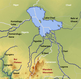
The Chadse with the El Beid (center) |
||
| Data | ||
| location |
State Borno Cameroon Province Extrême-Nord |
|
| River system | El Beid | |
| origin | Northern flank of the Mandara Mountains | |
| delta |
Lake Chad ( without any outflow), north of Fotokol Coordinates: 12 ° 32 ′ 0 ″ N , 14 ° 11 ′ 0 ″ E 12 ° 32 ′ 0 ″ N , 14 ° 11 ′ 0 ″ E
|
|
| Catchment area | 22,640 km² | |
| Discharge at the Fotokol A Eo gauge : 12,500 km² Location: 25 km above the estuary |
NNQ MNQ 1953-1968 MQ 1953-1968 Mq 1953-1968 MHQ 1953-1968 |
0 l / s 300 l / s 45.3 m³ / s 3.6 l / (s km²) 176 m³ / s |
| Medium-sized cities | Photo col | |
| Small towns | Limani, Banki | |
The El Beid is a river in northeast Nigeria and northern Cameroon , regionally it is known as the Ebeji .
origin
Its headwaters are located at 11 ° north on the northern flank of the Mandara Mountains and it flows in a northerly direction towards Lake Chad , which it has only reached seasonally at the end of the monsoon season since the 1980s. The size of its water catchment area is approx. 22,640 km², in the east of the state of Borno and in the west of the province of Extrême-Nord .
course
The El Beid river forms the border between Cameroon and Nigeria, over a length of approx. 400 km. It receives its water masses mainly from three sources: - the direct runoff from the headwaters, - the floodplain of the Grand Yaeres , which is inundated by Logone , and the relatively small overflow of the Serbewel river. It is also considered to be the most water-rich river in the Nigerian part of the Chad Basin , which flows into Lake Chad.
Hydrology
The El Beid forms numerous smaller canals flowing westwards on the lower reaches, but these seep away. Meanwhile the main stream flows into Lake Chad in a small delta. The main flood season on El Beid begins in November when the Grand Yareres begins to dry up. During this time it receives up to 150 m³ / second of water from the Logone flood in an average of years. For this hydrological reason , the El Beid is also partially included in the Schari / Logone river system, which together feeds between 95 and 99% of its water masses to Lake Chad. The annual runoff of the El Beid is given as 1.15 billion m³ and the average water temperature varies between 17 and 27 ° C.
The flow rate of the river was measured in Fotocol , in m³ / s. The annual average was 45.3 m³ / s.

Individual evidence
- ↑ a b Transboundary Diagnostic Analysis of the Lake Chad Basin ( Memento of the original from March 4, 2016 in the Internet Archive ) Info: The archive link was inserted automatically and has not yet been checked. Please check the original and archive link according to the instructions and then remove this notice. Author: DR HASSAN HARUNA BDLIYA, FEDERAL MINISTRY OF ENVIRONMENT AND HOUSING FEDERAL SECRETARIAT MAITAMA, ABUJA PDF document (English)
- ↑ a b PDF on the hydrology of Cameroon (French) Accessed June 22, 2018
- ↑ Monitoring the Decrease of Lake Chad frome Space Author: Lucien Wald Ecole National Supèrieur des Mines de Paris (English) PDF document
- ↑ "Chari-Logone and Lake Chad sub-system", UNEP publication, English ( Memento of the original from December 20, 2015 in the Internet Archive ) Info: The archive link has been inserted automatically and has not yet been checked. Please check the original and archive link according to the instructions and then remove this notice. (PDF; 4.3 MB)
- ↑ Ramsar information about Cameroon ( Memento of the original from July 28, 2011 in the Internet Archive ) Info: The archive link was inserted automatically and has not yet been checked. Please check the original and archive link according to the instructions and then remove this notice. PDF document
