Extreme north
|
High North Extreme North (French) Far North (English) |
|
|---|---|
| Basic data | |
| Capital : | Maroua |
| Area : | 34,246 km² |
| Residents : | 3,993,000 (calculation, 2015) |
| Population density : | 116.50 inhabitants / km² (calculation, 2015) |
| ISO 3166-2 : | CM-EN |
The High North ( French Extreme North or English Far North ) is a region of Cameroon with the capital Maroua .
geography
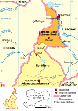
The region is located in the north of the country and has the shape of an area corridor . It borders on Chad to the north, east and south-east, the north region in the south-west and Nigeria to the west . The topography of the region is in the south of the Mandara Mountains , in the central part of the plains of the Waza-level and Firki levels of the Chad Basin determined in the north. The course of the border with Nigeria is marked by the El Beid river , while the Logone and Schari rivers form that to Chad . In the north, the province holds even smaller shares of the open water area of Lake Chad . The province is of great ecological importance due to its large floodplains, so two national parks were established as early as the 1930s. These are the 45 km² Kalamalou National Park in the north and the 1700 km² Waza National Park in the southwest.
Population development
Since 1976, the population has almost tripled.
| year | population |
|---|---|
| 1976 census | 1,394,765 |
| 1987 census | 1,855,695 |
| 2005 census | 3,111,792 |
| 2015 estimate | 3,993,000 |
Political structure
The region is divided into 6 districts. In the table below, the district capital is assigned to the respective district.
| district | District capital |
|---|---|
| Diamaré | Maroua |
| Mayo Kani | Kaélé |
| Logone-et-Chari | Kusseri |
| Mayo Danay | Yagoua |
| Mayo sava | Mora |
| Mayo tsanaga | Mokolo |
history
The region (until 2008 province) was created in 1983 with the division of the province north ( North ) into the provinces Adamaua , High North and today's region North (North) .


