
Borno
| Borno | |
|---|---|
 |
|
| Basic data | |
| Capital : | Maiduguri |
| founded: | 3rd February 1976 |
| Governor : | Babagana Umara Zulum |
| ISO 3166-2 : | NG-BO |
| surface | |
| Area : | 70,898 km² |
| Rank in Nigeria: | 2 |
| population | |
| Residents : | 5,860,200 (2016) |
| Population density : | 83 inhabitants / km² (2016) |
| Rank in Nigeria: | 8th |

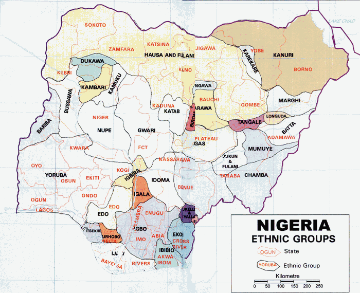
Borno is the northernmost state of the West African country Nigeria . The capital is Maiduguri , which with 1,112,511 inhabitants (2005) is also the largest city in the state. The dominant population group are the Kanuri , the predominant religion is Sunni Islam .
geography
The state is located in the northeast in the Nigerian part of the Chad Basin and borders in the northwest with the Republic of Niger , in the northeast with Chad , in the south with the state Adamawa , in the west with the states of Yobe and Gombe and in the east with Cameroon . The Chingurmi-Duguma area on the eastern border with Cameroon is protected on 1228 km² and is part of the Chad Basin National Park . The topography of the state is divided into two regions, the flatlands of the Chad Basin in the north and the mountainous regions of the Biu Plateau in the southwest and the Mandara Mountains in the southeast. The longest river in the region is the Yedseram , which has its source in the Mandara Mountains and flows northeast towards Lake Chad , which it has not reached since the 1980s. During the high water season in the Sambisa swamps it feeds the other large river in the region, the Ngadda . This is dammed at the Alau Reservoir , the main source of drinking water in the provincial capital Maiduguri, feeds the Jere Bow wetlands and flows northwards along the Bama Beach Ridge. The Bama Beach Ridge is a low ridge that formed the coast of the Mega Lake Chad about 6000 years ago and consists of inactive sand dunes that are covered with grass vegetation. The border with Cameroon is formed by the El Beid , which is considered to have the richest water in the region. The state's former part of Lake Chad has been a wetland since the 1980s , which was added to the list of wetlands of international importance by the Ramsar Convention in 2008 under the title Lake Chad Wetlands in Nigeria .
history
The excavation sites of the Gajiganna culture , southeast of Lake Chad , point to a long, uninterrupted history of settlement on the territory of the state .
Based on the continuing historical Emirates Borno on February 3, 1976, the state was formed from part of the former state "North-Eastern". The first governor was Muhammadu Buhari between February 1976 and March 1976.
politics
The current governor has been Kashim Shettima since May 29, 2011 . The Emirates still exist today as monarchies, which are sub-national entities. However, the emirs only have an advisory role.
In the state of Borno, Islamic law, the Sharia , applies , which acts as the source of legislation and case law.
Governors and administrators
- Muhammadu Buhari (governor 1976)
- Mustapha Amin (Governor 1976–1978)
- Tunde Idiagbon (Governor 1978–1979)
- Mohammed Goni (Governor 1979–1983)
- Sheikh Jarma (Governor 1983)
- Abubakar Waziri (Governor 1984–1985)
- Abdul Mumini Aminu (governor 1985–1987)
- Abduwan Mohammed (governor 1987–1989)
- Mohammed Maina (governor 1989–1990)
- Mohammed Marwa (Governor 1990–1992)
- Maina Maaji Lawan (Governor 1992–1993)
- Ibrahim Dada (administrator 1993–1996)
- Victor Ozodunobi (Administrator 1996–1998)
- Lawal Haruna (Administrator 1998–1999)
- Mala Kachalla (Governor 1999-2003)
- Ali Modu Sheriff (Governor 2003-2011)
- Kashim Shettima (Governor 2011-2019)
- Babagana Umara Zulum (Governor 2019–)
administration
The state is divided into 27 Local Government Areas . These are: Abadam, Askira-Uba, Bama, Bayo, Biu, Chibok, Damboa, Dikwa, Gubio, Guzamala, Gwoza, Hawul, Jere, Kaga, Kala-Balge, Konduga, Kukawa, Kwaya-Kusar, Mafa, Magumeri, Maiduguri , Marte, Mobbar, Monguno, Ngala, Nganzai and Shani.
economy
The agriculture is the main industry in Borno. There are millet , rice , cassava , dates , vegetables , sorghum , wheat , potatoes , beans , sugar cane , peanuts , cotton and rubber grown and livestock operation.
The state exports decorative leatherwork , shoes , adhesives , gelatine and other goods. The fishing and fish processing are significant.
Infrastructure
Borno has a well-developed infrastructure and connections to other states by air, rail and road . There is an international airport in Maiduguri .
Individual evidence
- ^ Ethnic classification of Nigeria
- ↑ Jacob K. Nyanganji: The Morphology and Hydrography of the Ngadda River Catchment and the Bama Beach Ridge (BBR) . ( Memento of the original from October 29, 2013 in the Internet Archive ) Info: The archive link was inserted automatically and has not yet been checked. Please check the original and archive link according to the instructions and then remove this notice. Department of Geography, Bayero University Kano, Nigeria
- ↑ Natural description of the country on Onlinenigeria.com
- ↑ Hassan Haruna Bdliya: Transboundary Diagnostic Analysis of the Lake Chad Basin . ( Memento of the original from March 4, 2016 in the Internet Archive ) Info: The archive link was inserted automatically and has not yet been checked. Please check the original and archive link according to the instructions and then remove this notice. (PDF) Federal Ministry Of Environment And Housing Federal Secretariat Maitama, Abuja (English)
- ↑ The Annotated Ramsar List: Nigeria ( Memento of October 12, 2013 in the Internet Archive ) (English)
- ↑ Oladimeji Aborisade, Robert J. Mundt: Politics in Nigeria . Longman, New York 2002.
Abia |
Adamawa |
Akwa Ibom |
Anambra |
Bauchi |
Bayelsa |
Benue |
Borno |
Cross River |
Delta |
Ebonyi |
Edo |
Ekiti |
Enugu |
Gombe |
Imo |
Jigawa |
Kaduna |
Kano |
Katsina |
Kebbi |
Kogi |
Kwara |
Lagos |
Nassarawa |
Niger |
Ogun |
Ondo |
Osun |
Oyo |
Plateau |
Rivers |
Sokoto |
Taraba |
Yobe |
Zamfara
Federal Capital Territory