Ngadda
| Ngadda | ||
|
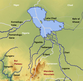
The Chadse with the Ngadda (center) |
||
| Data | ||
| location |
State of Borno |
|
| River system | Ngadda | |
| origin | Northwest flank of the Mandara Mountains | |
| Infiltration and evaporation |
Chad , east of Monguno coordinates: 12 ° 40 '0 " N , 13 ° 50' 0" O 12 ° 40 '0 " N , 13 ° 50' 0" O
|
|
| Catchment area | 14,400 km² | |
| Reservoirs flowed through | Alau reservoir | |
| Big cities | Maiduguri | |
|
Satellite image of the course of the Ngadda through Lake Alau (south), the city of Maiduguri (west) and the Jere-Bowl wetland (north) |
||
The Ngadda is a river in northeastern Nigeria .
course
It is a permanent river on the upper reaches and a seasonal river on the lower reaches. Its sources lie on the northwest flank of the Mandara Mountains and it flows in a north-easterly direction towards Lake Chad , which it has not reached since the 1980s. The size of its water catchment area is approximately 14,400 km², in the east of the state of Borno .
On its upper course it flows through the approximately 130 km² Sambisa swamps , about 50 km southeast of Maiduguri. In this marshland its course is not defined. Here it receives the river Yedseram, which also crosses the swamps, with an annual volume of approx . Its name derives from this water exchange phenomenon, which comes from the language of the Kanuri people . After leaving the Sambissa swamps, the Ngadda is dammed at the Alau reservoir , which was built in 1987 and first reached its maximum storage volume of 345 million m³ in 1992. After leaving the reservoir, it flows through the Nigerian city of Maiduguri and irrigates the Jere-Bowl wetlands, in the flood season and flows along the Bama Beach Ridge, before it forms a river delta east of Monguno on the former shores of the normal Lake Chad and irrigates the Lake Chad wetlands or seeps away.
environmental pollution
The river suffers from the garbage from the city of Maiduguri. Analyzes of soil samples revealed greatly increased heavy metal concentrations.
Individual evidence
- ↑ a b Transboundary Diagnostic Analysis of the Lake Chad Basin ( Memento of the original from March 4, 2016 in the Internet Archive ) Info: The archive link was inserted automatically and has not yet been checked. Please check the original and archive link according to the instructions and then remove this notice. ; Cross-border diagnostic analysis of the Lake Chad '(Author: Dr. Hassan Haruna Bdliya, PDF, English)
- ^ The Physical Setting of Nigeria ; the Ngadda in the regional description of the state
- ^ A b The History and Future of Water Management of the Lake Chad Basin in Nigeria ; History and future of water management at Lake Chad '(Author: Roger Blench, PDF, English; 1.6 MB)
- ↑ The Morphology and Hydrography of the Ngadda Catchment and the Bama Beach Ridge ( Memento of the original from October 29, 2013 in the Internet Archive ) Info: The archive link was automatically inserted and not yet checked. Please check the original and archive link according to the instructions and then remove this notice. ; The morphology and hydrography of the catchment area of the Ngadda and the shore at Bama Beach '(Author: Jacob Kondu Nyanganji, English)
- ↑ OGUNKOYA & Dami: Information Sheet on Ramsar Wetlands (RIS) - 2006-2008 Version ( Memento of the original from October 29, 2013 in the Internet Archive ) Info: The archive link was inserted automatically and has not yet been checked. Please check the original and archive link according to the instructions and then remove this notice. on Wetlands.org (PDF document; 167 kB) (English)
- ^ [1] Heavy Metals in Sediments from River Ngada, Maiduguri Metropolis, Borno State, Nigeria (pdf)

