Yedseram
| Yedseram | ||
|
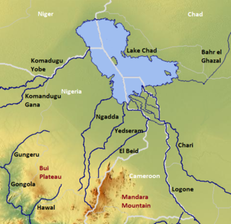
The Chadse with the Yedseram (center) |
||
| Data | ||
| location |
State of Borno |
|
| River system | Yedseram | |
| origin | Confluence of Digil and Mayo-Muvur near Uba on the northwest flank of the Mandara Mountains 10 ° 26 ′ 45 ″ N , 13 ° 14 ′ 17 ″ E |
|
| Infiltration | East of Dikwa Coordinates: 12 ° 2 ′ 9 ″ N , 14 ° 1 ′ 15 ″ E 12 ° 2 ′ 9 ″ N , 14 ° 1 ′ 15 ″ E
|
|
| Catchment area | 16,320 km² | |
| Medium-sized cities | Bama , Mubi | |
The Yedseram is a river in northeastern Nigeria .
course
It is a permanent river on the upper reaches and a seasonal river on the lower reaches. Its sources are on the northwest flank of the Mandara Mountains , and it generally flows in a northeastern direction towards Lake Chad , which it has not reached since the 1980s. The size of its water catchment area is approximately 16,320 km², in the east of the state of Borno .
Hydrology
On its upper course it flows through the approximately 130 km² Sambisa swamps , about 30 km southwest of Bama . In this marshland its course is not defined. Here it feeds the Ngadda River, which also crosses the swamps, with around 127 million m³ annually . The Yedseram forms a river delta on the former shores of the normal Lake Chad and is one of the main tributaries of the Lake Chad wetlands , which arose after the retreat of Lake Chad.
Individual evidence
- ↑ a b Transboundary Diagnostic Analysis of the Lake Chad Basin ( Memento from March 4, 2016 in the Internet Archive ), Hassan Haruna Bdliya, Federal Ministry of Environment and Housing (PDF document, English)
- ↑ The yedseram in the regional description of the state (English)
- ↑ The History and Future of Water Management of the Lake Chad Basin in Nigeria , Roger Blench, University of Cambridge (PDF document, English)
- ↑ Ogunkoya & Dami: Information Sheet on Ramsar Wetlands (RIS) - 2006-2008 Version ( Memento from October 29, 2013 in the Internet Archive ) on Wetlands.org (PDF document; 167 kB) (English)
