
States of Nigeria
The 36 federal states of Nigeria are the highest administrative unit of the West African Federal Republic of Nigeria . Each state has its own government, headed by a directly elected governor, and its own state parliament. Below the state level there are 774 subordinate Local Government Areas .
Table overview
The table lists the 36 states of Nigeria and the Federal Capital Territory around the capital Abuja alphabetically, sortable by area, population and capital. The population figures refer to the censuses (VZ) of November 26, 1991 and March 21, 2006 as well as estimates for 2015 based on the results of the 2006 census.


(VZ = census) (estimate = estimate)
| State | Area in km² | VZ 1991 | VZ 2006 | Sch. 2015 | Capital |
|---|---|---|---|---|---|
| Abia | 6.320 | 2,338,487 | 2,833,999 | 3,622,900 | Umuahia |
| Adamawa | 36,917 | 2,102,053 | 3,168,101 | 4,120,200 | Yola |
| Akwa Ibom | 7,081 | 2,409,613 | 3,920,208 | 5,286,900 | Uyo |
| Anambra | 4,844 | 2,796,475 | 4,182,032 | 5,366,900 | Awka |
| Bauchi | 45,837 | 2,861,887 | 4,676,465 | 6,304,500 | Bauchi |
| Bayelsa | 10,773 | 1,121,693 | 1,703,358 | 2,209,200 | Yenagoa |
| Need | 34,059 | 2,753,077 | 4,219,244 | 5,562,400 | Makurdi |
| Borno | 70,898 | 2,536,003 | 4,151,193 | 5,651,500 | Maiduguri |
| Cross River | 20,156 | 1,911,297 | 2,888,966 | 3,749,600 | Calabar |
| delta | 17,698 | 2,590,491 | 4,098,391 | 5,474,000 | Asaba |
| Ebonyi | 5,670 | 1,029,312 | 2,173,501 | 2,796,500 | Abakaliki |
| Edo | 17.802 | 2,172,005 | 3,218,332 | 4,116,900 | Benin city |
| Ekiti | 6,353 | 1,535,790 | 2,384,212 | 3,165,000 | Ado Ekiti |
| Enugu | 7.161 | 2,125,068 | 3,257,298 | 4,273,200 | Enugu |
| Federal Capital Territory | 7,315 | 371.674 | 1,405,201 | 3,195,100 | Abuja |
| Gombe | 18,768 | 1,489,120 | 2,353,879 | 3,148,100 | Gombe |
| Imo | 5,530 | 2,485,635 | 3,934,899 | 5,227,900 | Owerri |
| Jigawa | 23,154 | 2,875,525 | 4,348,649 | 5,652,200 | Dutse |
| Kaduna | 46.053 | 3,935,618 | 6,066,562 | 7,994,400 | Kaduna |
| Kano | 20,131 | 5,810,470 | 9,383,682 | 12,625,500 | Kano |
| Katsina | 24.192 | 3,753,133 | 5,792,578 | 7,586,500 | Katsina |
| Kebbi | 36,800 | 2,068,490 | 3,238,628 | 4,296,400 | Birnin Kebbi |
| Kogi | 29,833 | 2,147,756 | 3,278,487 | 4,333,600 | Lokoja |
| Kwara | 36,825 | 1,548,412 | 2,371,089 | 3,093,100 | Ilorin |
| Lagos | 3,345 | 5,725,116 | 9,013,534 | 12,131,000 | Ikeja |
| Nassarawa | 27,117 | 1,207,876 | 1,863,275 | 2,444,500 | Lafia |
| Niger | 76,363 | 2,421,581 | 3,950,249 | 5,358,400 | Minna |
| Ogun | 16,762 | 2,333,726 | 3,728,098 | 5,037,600 | Abeokuta |
| Ondo | 14,606 | 2,249,548 | 3,441,024 | 4,525,600 | Akure |
| Osun | 9,251 | 2,158,143 | 3,423,535 | 4,548,300 | Oshogbo |
| Oyo | 28,454 | 3,452,720 | 5,591,589 | 7,561,600 | Ibadan |
| plateau | 30,913 | 2,104,536 | 3,178,712 | 4,082,700 | Jos |
| Rivers | 11,077 | 3,187,844 | 5,185,400 | 7,043,800 | Port Harcourt |
| Sokoto | 25,973 | 2,418,585 | 3,696,999 | 4,841,800 | Sokoto |
| Taraba | 54,473 | 1,512,163 | 2,300,736 | 2,974,300 | Jalingo |
| Yobe | 45.502 | 1,399,687 | 2,321,591 | 3,173,200 | Damaturu |
| Zamfara | 39,762 | 2,051,591 | 3,259,846 | 4,364,500 | Gusau |
| Nigeria | 923,768 | 88.992.220 | 140.003.542 | 186,939,800 | Abuja |
State history
As a colony, Nigeria was divided into a Protectorate of Northern Nigeria and a Protectorate of Southern Nigeria , later divided into a Northern, an Eastern and a Western province and Lagos . After independence in 1960, these provinces were renamed regions.
A territorial reform passed in May 1967, which divided Nigeria into twelve federal states, was one of the triggers of the Biafra War , i.e. the secession of the former eastern province of Biafra, since Nigeria's petroleum regions were withdrawn from the Igbo's access through the new borders .
Federal states have existed since 1967 - initially there were 12, from 1976 19, from 1987 21, from 1991 30 and since 1996 the country has been divided into 36 federal states.
The territorial development of the states:

1963–1967 : 4 countries

1967–1976 : 12 states

1976–1987 : 19 states
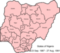
1987–1991 : 21 states, later plus Abuja
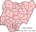
1991–1996 : 29 states plus Abuja


