Adamawa (State)
| Adamawa | |
|---|---|
| Basic data | |
| Capital : | Yola |
| biggest town: | Jimeta |
| founded: | 3rd February 1976 |
| Governor : | Bindo Jibrilla |
| ISO 3166-2 : | NG-AD |
| surface | |
| Area : | 36,917 km² |
| Rank in Nigeria: | 8th |
| population | |
| Residents : | 4,248,400 (2016) |
| Population density : | 115 inhabitants / km² (2016) |
| Rank in Nigeria: | 24 |
Adamawa is a federal state in the West African country of Nigeria with the capital Yola . The largest city is Jimeta with 248,166 inhabitants (2005). The name is derived from Modibo Adama , the founder of the Emirates Adamaua .
geography
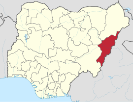
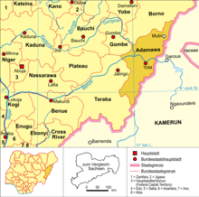
The state is located in the east of the country and borders the state of Borno to the north, the state of Gombe to the northwest , the state of Taraba to the southwest and Cameroon to the east . Across from Numan , the Gongola flows into the largest tributary of the Niger , the Benue .
population
The population predominantly speaks Adamawa Eastern languages (in the center and in the east) of the Adamawa Ubangi languages and Igbo (in the south) within the Niger-Congo languages , which are also spoken in neighboring Cameroon. English is also spoken as a lingua franca.
history
Adamawa used to be part of the Emirates Adamaua . The state was formed on February 3, 1976 under the name Gongola from part of the former state of North-Eastern. On August 27, 1991, it was renamed Adamawa.
List of governors and administrators
- Abubakr Salihu (Governor 1991–1992)
- Abubakar Saleh Michika (Governor 1992–1993)
- Gregory Agboneni (administrator 1993–1994)
- Mustapha Ismail (Administrator 1994–1996)
- Joe Kalu-Igboama (Administrator 1996-1998)
- Ahmadu G. Husseni (Administrator 1998–1999)
- Boni Haruna (Governor 1999-2007)
- Murtala Nyako (governor 2007-2008)
- James Shaibu Barka (Governor 2008)
- Murtala Nyako (Governor 2008-2014)
- Alhaji Ahmadu Umaru Fintirin (Governor 2014)
- Bala James Ngilari (Governor 2014-2015)
- Bindo Jibrilla (Governor 2015–)
administration
The state is divided into 21 Local Government Areas . These are: Demsa, Fufure, Ganye, Gayuk, Gombi, Grie, Hong, Jada, Larmurde, Madagali , Maiha, Mayo-Belwa, Michika, Mubi North, Mubi South, Numan, Shelleng, Song, Teungo, Yola North and Yola South .
economy
The majority of the working population in Adamawa is employed in agriculture . The climatic and ecological conditions allow the cultivation of grain , cotton , peanuts , corn , yams , cassava , millet and rice . Fishing and livestock farming are also important industries .

