Need
| Need | ||
|
Catchment area of the Benue |
||
| Data | ||
| location |
|
|
| River system | Niger | |
| Drain over | Niger → Atlantic Ocean | |
| source |
Adamaua Highlands 7 ° 33 ′ 15 ″ N , 13 ° 32 ′ 52 ″ E |
|
| Source height | 1350 m | |
| muzzle | in Niger near Lokoja Coordinates: 7 ° 47 ′ 0 ″ N , 6 ° 45 ′ 0 ″ E 7 ° 47 ′ 0 ″ N , 6 ° 45 ′ 0 ″ E
|
|
| length | 1400 km | |
| Catchment area | 335,035 km² | |
| Discharge at the gauge Riao (1335014) A Eo : 30,650 km² |
NNQ (min. Month Ø) MNQ 1950–1980 MQ 1950–1980 Mq 1950–1980 MHQ 1950–1980 HHQ (max. Month Ø) |
0 l / s 800 l / s 249 m³ / s 8.1 l / (s km²) 1268 m³ / s 2162 m³ / s |
| Discharge at the level at the mouth (before 1960) A Eo : 335,035 km² |
MQ Mq |
3400 m³ / s 10.1 l / (s km²) |
| Left tributaries | Faro , Taraba , Katsina Ala | |
| Right tributaries | Mayo kebi , gongola , kadera , ssungo | |
| Reservoirs flowed through | Lagdo reservoir | |
| Big cities | Garoua | |
| Medium-sized cities | Yola | |
| Navigable | yes (to Garoua) | |
|
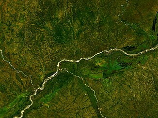
Satellite image of the Benue |
||
Benue (emphasis on both "e"; also Binue, Binuë, Bénoué , Bantu language for mother of the waters , Tschadda ) is a river in central Africa and at the same time the largest tributary of the Niger .
course
The source of the Benue is north of Ngaoundéré in the southern highlands of Adamaua at 7 ° 33 'north latitude and about 13 ° 33' east longitude. From there the river moves northwards in a large arc that is open to the west, receives the Mayo-Kebi coming from the east at Gewe , now turns westwards and joins 206 m above sea level. M. with the raging and water-rich Faro coming from the south (the main river here is 1000 m, the tributary 700 m wide). From the right it takes the Gongola as the longest tributary , then the Kadera and the Ssungo . In the rainy season the water, which is 3-4 m deep, rises by 10-15 m and causes huge floods . Below Adamaua the river majestically traverses a wide valley with pronounced valley edges; the interior of the country is mostly filled with forest thickets in the south, torn by ravines and inaccessible, in the north it is more cultivated. At 7 ° 46 ′ north latitude, the Benue flows into the Niger opposite Lokoja .
Hydrometry
At the confluence, the Benue is larger than the Niger. Before 1960 its mean discharge was 3400 m³ / s compared to 2500 m³ / s of the Niger. During the following decades, the water supply of both rivers fell by more than a third, mainly due to the growing demand for water in agriculture.
The flow rate of the Benue was measured at the Riao gauge at almost 10% of the catchment area in m³ / s.

Exploration and history
The Benue was discovered in 1851 by Heinrich Barth and again in 1854 by Eduard Vogel ; William Balfour Baikie was the first to take him in 1854 and 1857-58 with a steamboat to close to the borders of Adamaua. Since then, its lower reaches have been used very often, for example by Gerhard Rohlfs , Adolph Burdo and Eduard Flegel , who also discovered the source in 1882. Flowing through wide fertile and rich countries, this river was once one of the most important entry gates to Inner Africa. The most important place on its banks in the 19th century was Yola in Adamaua, the then port for ivory (60–80 tons annually); further west, a little south of the Benue, is the equally important Wukari.
From Adamaua onwards, the Benue formed the border between the Sokoto Ful region and the southern Yoruba lands in the 19th century .
See also
Web links
Individual evidence
- ↑ Jaroslab Balek: Hydrology and Water Resources in Tropical Africa . Elsevier, 1977, ISBN 0-444-99814-4 , p. 90 ( excerpt (Google) )
- ↑ Station Description Form - Benue à Umaisha: 1331700101 - NIGERIA
- ↑ a b GRDC - Riao level
- ^ Inger Andersen: The Niger River Basin: A Vision for Sustainable Management . World Bank Publications 2005, ISBN 0-8213-6203-8 , p. 46 ( excerpt (Google) )
- ^ Deutsches Kolonial-Lexikon (1920), search term Benue
- ^ Russian general staff map


