Komadugu Yobe
|
Komadugu Yobe Komadougou Yobé, Yobe River |
||
|
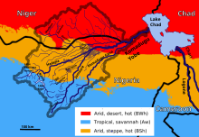
Map of the catchment area of the Yobe |
||
| Data | ||
| location |
|
|
| River system | Komadugu Yobe | |
| origin | Confluence of Hadejia and Jama'are southwest of Gashua 12 ° 39 '6 " N , 10 ° 38' 50" O |
|
| muzzle | in Lake Chad coordinates: 13 ° 40 '24 " N , 13 ° 23' 36" E 13 ° 40 '24 " N , 13 ° 23' 36" E |
|
| Mouth height |
280 m
|
|
| length | 1200 km (together with the source river Hadejia) | |
| Catchment area | 148,000 km² | |
| Discharge at the Bagara Diffa gauge (1237500) A Eo : 115,000 km² Location: 100 km above the mouth |
MNQ 1967–1991 MQ 1967–1991 Mq 1967–1991 MHQ 1967–1991 HHQ (max. Month Ø) |
0 l / s 15 m³ / s 0.1 l / (s km²) 45.8 m³ / s 71 m³ / s |
| Right tributaries | Komadugu Gana | |
|
Komadugu Yobe in 1900 |
||
The Komadugu Yobe , the French spelling is Komadougou Yobé and is mainly used in Niger , is a river that has its headwaters in northeastern Nigeria . In Nigeria it is also known simply as the Yobe River .
geography
It arises from the confluence of the Hadejia and Jama'are southwest of Gashua , then flows along the border with Niger, in parts it is also completely in Niger and originally flowed into Lake Chad , whose open water it has not reached since the late 1980s . The size of its catchment area, including its headwaters, is about 148,000 km² and is known as the Komadougou Yobe Basin , a sub-basin of the Chad Basin . Of this catchment area, 85,000 km² are in Nigeria and 63,000 km² in Niger. Its right tributary, the Komadugu Gana , reaches the Komadugu Yobe only intermittently and flows into the Komadugu Yobe in the area of Damasak , about 120 km before reaching the northern Lake Chad.
At the confluence of Hadejia and Jama'are, an inland delta of approx. 6000 km² forms seasonally , which is known as the Hadejia-Nguru wetlands and is of international importance. A branch of the Hadejia, the Marma Canal, leads to the outflow-free Nguru Lake . This is part of a wetland of international importance and is surrounded by a protected area according to the Ramsar Convention and is part of the bathing Nguru sector of the Nigerian national park Chad Basin . Three other protected areas under the Ramsar Convention are Lake Maladumba , Lake Chad Wetlands in Nigeria and the Baturiya Wetlands .
Several dams are located in the Komadugu Yobe catchment area. Including the Challawa Gorge , the Tiga and the Bagauda .
Hydrometry
The flow rate of the Komadugu Yobe was measured over 24 years (1967-91) in Bagara Diffa about 100 kilometers upstream from the mouth (in m³ / s).

Climate in the catchment area
The amount of precipitation in the catchment area of the Komadugu Yobe is very different, in the area of the southern source rivers fall about 1000 to 1.600 l / m². In the region of the confluence of the Hadeija and Jama'are rivers, an average of 500 l / m² of precipitation and in the area of Lake Chad only up to 300 l / m². In the northern part of the catchment area, in Niger, there is only 200 l / m² of precipitation per year. Accordingly, the northern tributaries only contribute to the outflow of the Yobe in exceptional cases. Most of them are wadis and dry valleys such as the Korama and usually do not reach the Yobe. They only carry water in the winter, but then, as is common in dry valleys in the Sahel zone, can cause dangerous floods.
The river forms the southern boundary of the Manga landscape .
swell
- Regional Definitions for Lake Chad (PDF file; 8.41 MB) ( Memento from September 30, 2006 in the Internet Archive ), p. 22 - part of a GIWA report by UNEP
- the Komadougou-Yobe on Lake Chad Basin Project ( Memento from July 13, 2017 in the Internet Archive )
- Pre-water audit for the Komadugu Yobe Basin ( Memento from April 9, 2017 in the Internet Archive ) (PDF file, 1.27 MB)
literature
- Salé Amadou Moumouni: Etude comparative de systèmes de cultures irriguées sur le périmètres collectifs et individuels dans la vallée de la Komadougou Yobé . Faculté d'Agronomie, Université Abdou Moumouni de Niamey, Niamey 2001.
Web links
Individual evidence
- ↑ a b GRDC - The Komadugu Yobe in Bagara Diffa
- ↑ The Annotated Ramsar List: Nigeria ( Memento of November 24, 2013 in the Internet Archive ) (English)
- ↑ Abdourahmane Idrissa, Samuel Decalo: Historical Dictionary of Niger . 4th edition. Scarecrow, Plymouth 2012, ISBN 978-0-8108-6094-0 , pp. 314 .


