Milseburgradweg
| Milseburgradweg | |
|---|---|

|
|
| overall length | 27 km |
| location |
|
| map | |
| Link to map and elevation profile | |
| Starting point | Petersberg-Götzenhof |
| Target point | Hilders |
| Places along the way | Petersberg-Götzenhof , Untergötzenhof , Almendorf , Melzdorf , Wiesen , Niederbieber , Langenbieber , Schackau , Elters , Steinbach , Rupsroth , Liebhards , Eckweisbach , Aura , Hilders |
| Flooring | asphalted |
| Height difference |
300 m to 600 m / approx. 375 m ascent |
| difficulty | light |
| Traffic volume | low |
| Connection to |
Railway cycle path Hessen , Hessischer Radfernweg R3 |
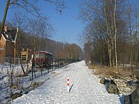
The after Milseburg named Milseburgradweg leads as part of the Hessian cycle route R3 on the former Rhön railway line Biebertal web / Rhön web over a length of 27 kilometers of Petersberg - Götzenhof to Hilders by the Hessian Rhön and is thus one of the bike paths on set-aside railway tracks . Today the cycle route is part of the Hessen Cycle Route ; see there for more details.
Route
The continuously paved Milseburgradweg begins in the west at a parking lot in Götzenhof northeast of Fulda and ends in the east just behind the former Hilders train station in the Ulstertal . If you drive the extensively signposted route from west to east, you will pass the following villages: Untergötzenhof, Almendorf, Melzdorf, Wiesen , Niederbieber , Langenbieber , Schackau, Bieberstein, Elters , Steinbach, Rupsroth, Liebhards and Eckweisbach. The course of the route without extreme climbs (max. 3%) makes it possible for less trained cyclists to cross a low mountain range . The Milseburgradweg can also be used by pedestrians and inline skaters, for whom the path is well suited as the asphalt is not too rough. For the cyclists there are not only beautiful resting places with shelters and information boards, but also kilometer information and signs that point to churches, castles, museums, limestone cliffs, children's playgrounds and other excursions. The highlight of the cycle path is definitely the 1172 meter long Milseburg tunnel . The tunnel, which dates back to 1889 , is usually open from April 15th to October 31st, and in winter it is a resting room for bats; Depending on how much the bats need to rest, the opening time can be shortened. A four-kilometer bypass route is available during the closure period. The highest point of the route is the former Milseburg train station. New bridges were built to cross some state and district roads. As a safety device there are jostling bars in front of the streets at the same height, since the crossing car traffic has priority.
getting there
In addition to special parking spaces along the route, the Rhein-Main-Verkehrsverbund (RMV) buses with bicycle trailers serve the stops along the cycle path on Sundays and public holidays and bring passengers with their bicycles to Fulda, Hilders, Gersfeld and the Wasserkuppe (Rhönradbus , see web link).
Connections to other national cycle routes
- Ulster cycle path from Hilders to Vacha
- This offers two tours:
- Fulda – Milseburgradweg – Ulsterradweg– Kegelspiel-Radweg - Haunetal-Radweg –Fulda
- Fulda Milseburgradweg-Ulsterradweg- Werra cycle path - Fulda bike trail -Fulda
- Hessian long-distance cycle route R1 near Fulda
literature
- Norman Zellmer: Bat Quarter reopened , in: Fuldaer Zeitung from April 15, 2011 ( online )
Web links
- www.milseburgradweg.de - Official website of the cycle path
- Milseburgradweg with picture documentation In: www.bahntrassenradwege.de
- Milseburgradweg In: Hesse cycle route planner.
Coordinates: 50 ° 34 '40.3 " N , 9 ° 43' 8.7" E


