
Jimbolia
|
Jimbolia Hatzfeld Zsombolya |
|||||
|
|||||
| Basic data | |||||
|---|---|---|---|---|---|
| State : |
|
||||
| Historical region : | Banat | ||||
| Circle : | Timiș | ||||
| Coordinates : | 45 ° 48 ' N , 20 ° 43' E | ||||
| Time zone : | EET ( UTC +2) | ||||
| Height : | 82 m | ||||
| Area : | 79.7 km² | ||||
| Residents : | 10,808 (October 20, 2011) | ||||
| Population density : | 136 inhabitants per km² | ||||
| Postal code : | 305400 | ||||
| Telephone code : | (+40) 02 56 | ||||
| License plate : | TM | ||||
| Structure and administration (as of 2016) | |||||
| Community type : | city | ||||
| Mayor : | Darius Adrian Postelnicu ( PNL ) | ||||
| Postal address : | St. Tudor Vladimirescu, no. 81 loc. Jimbolia, jud. Timiș, RO-305400 |
||||
| Website : | |||||


Jimbolia ( German Hatzfeld , Hungarian Zsombolya , Serbo-Croatian Žombolj / Жомбољ ) is a city with about 11,000 inhabitants in the Romanian Banat , in the Timiș district , 40 km west of Timișoara . In 1333 the place was first mentioned under the name Chumbul . During the German colonization of the Banat in 1766 the village was named Hatzfeld . In 1887 the first German newspaper appeared, the Hatzfelder Zeitung , which was discontinued in 1941. Stefan Jäger , the “painter of the Danube Swabians”, lived there from 1910 until his death in 1962. Hatzfeld was given the epithets “Weimar des Banats” and “Perle der Banater Heide”.
Neighboring places
| Banatsko Veliko Selo | Thank god | Lenauheim |
| Novi Kozarci |
.svg)
|
Cărpiniș |
| Rusko Selo | Srpska Crnja | Checea |
geography

The city of Jimbolia is located in the western part of Romania, 572 km (railway line) or 600 km (country road) from Bucharest . Within the Timiș District , Jimbolia is located on its western edge, on the border with Serbia , 39 km (railway line) from the district capital Timișoara. Geographically, Jimbolia belongs to the Banat Plain and is here again at the transition between the Temescher and Marosher plains. The city is about 82 m above sea level. It is located at the crossroads of important connecting routes between Romania and the ex-Yugoslav region and is an important border crossing point for both rail and road traffic.
In terms of population, Jimbolia ranks 175th out of a total of 261 cities in Romania. It ranks 4th within the circle. With 11,113 inhabitants (according to the 2002 census), the heath city is placed after Timișoara, Lugoj and Sânnicolau Mare and represents 1.5% of the total population and 2.5% of the urban population of the district.
The geological stratification is highly fragmented and is characterized by great tectonic mobility. In terms of the shape of the ground, one can speak of a Hatzfeld plain as part of the Marosch plain, which in turn forms the northern part of the Banat plain. The climate is characterized by temperatures with an annual mean value of +10.7 ° C. Precipitation falls on average 570 mm per year. From a hydrographic point of view, the rising geothermal deep waters are typical of the city's surroundings. The willow steppe characteristic of this area has largely been turned into arable land. The fertile fields belong to the category of black earth soils.
history
The city was first mentioned in a document in 1333 and operated in the literary sources under the names Chumbul, Chombol, Csomboly or Zsomboly. It initially belonged to the Kingdom of Hungary before it was conquered by the Ottomans in 1552 , with the local population fled and killed. In the Peace of Passarowitz in 1718, the urban area came under the rule of the Habsburgs , who began to colonize it again.
In addition to the village of Billed , Hatzfeld was one of the first heath villages to be re-established and rebuilt according to a uniformly planned geometric floor plan. The place built by the impopulation director Johann Wilhelm Edler von Hildebrand has a square floor plan, which is divided by five longitudinal streets and five cross streets that intersect at right angles.
From 1766 south German settlers colonized the area and founded the communities Hartfeld and Landstreu, which were united two years later under the name Hatzfeld. Until 1791, the village developed rapidly and received market and fair rights. After the revolution of 1848/49, the region became part of the Austrian crown land of the Voivodeship of Serbia and the Temesian Banat . In the next few years, in addition to the new Hansdorf district in 1857, the first railway line to Temesvar was set up. In 1861, Emperor Franz Joseph I re-validated the Hungarian constitution ( Austro-Hungarian Compromise ), which means that the city again belonged to the Hungarian part of the country, as it did before 1848. Under Hungarian administration, more and more Hungarians moved to the city, which was officially called Zsombolya from 1899 . At the same time, the city experienced an economic boom in the second half of the 19th century, which went hand in hand with the expansion of the railway lines and the emergence of branches of industry. The Futok district was also created .
At the end of the First World War in 1918, Hatzfeld was occupied by Serbia and was given the name Žombolj . The official affiliation to the SHS state took place through the Treaty of Trianon (1920). With the Belgrade Convention of November 24, 1923, the borders were adjusted by exchanging some municipalities. Modosch (Serbian: Jaša Tomić) and Parjan came to Yugoslavia. Hatzfeld with a 75 percent German majority went to Romania, as did Großscham (Romanian Jamu Mare ), Tschene ( Cenei ) and Neuburg an der Bega ( Uivar ). Another name change to Jimbolia took place in 1924 under Romanian administration . The streets were also given Romanian names. Romanians increasingly moved to the town, which again became the seat of the district. Economically, the city took off again, both in agriculture and in craft and industry. However, this was interrupted from 1929 by the global economic crisis .
As a result of the Waffen-SS Agreement of May 12, 1943 between the Antonescu government and Hitler's Germany , all men of German origin who were conscripted into the German army. With the receding Eastern Front in World War II , part of the German population fled towards Germany in 1944. Many of those who remained were deported to the Soviet Union in 1945 .
The Land Reform Act of March 23, 1945 , which provided for the expropriation of German farmers in Romania, deprived the rural population of Hatzfeld of their livelihood. The Nationalization Act of June 11, 1948 provided for the nationalization of all industrial and commercial enterprises, banks and insurance companies, whereby all commercial enterprises were expropriated regardless of ethnicity. 1951 took place by the Romanian state deportations in the Bărăgan . When the Bărăgan displaced people returned home in 1956, they got back the houses and farms that had been expropriated in 1945, but the land ownership was collectivized . A large part of the Germans who remained in Jimbolia and those returning from the Soviet Union and Bărăgan later emigrated to Germany.
In 1950 Jimbolia received city rights and was a district seat from 1956 to 1961. During this time there was a significant increase in population due to Romanian colonists from Dobruja and Moldova . Under the socialist order, private land was expropriated and businesses were nationalized. Nevertheless, German-speaking schools and a German-speaking cultural life existed. After the collapse of socialism there was an emigration of the German population after 1989.
| Historical population development | |||||||||||||
| year | population | Romanians | Hungary | German | |||||||||
|---|---|---|---|---|---|---|---|---|---|---|---|---|---|
| 1880 | 8,621 | 0.4% | 5.9% | 87.5% | |||||||||
| 1890 | 9,580 | 0.4% | 7.5% | 89.8% | |||||||||
| 1900 | 10.152 | 0.5% | 15.1% | 82.7% | |||||||||
| 1910 | 10,893 | 1 % | 20.8% | 74.2% | |||||||||
| 1930 | 10,873 | 6.1% | 19.3% | 70.3% | |||||||||
| 1941 | 10,781 | 8th % | 19.2% | 67.2% | |||||||||
| 1956 | 11,281 | 30.6% | 21.5% | 43.6% | |||||||||
| 1966 | 13,633 | 39% | 20.7% | 36.1% | |||||||||
| 1977 | 14,682 | 41.3% | 19.7% | 34.2% | |||||||||
| 1992 | 11,830 | 66.8% | 16.6% | 9.4% | |||||||||
| 2002 | 11,136 | 72.4% | 14.8% | 4.6% | |||||||||
| 2011 | 10,808 | 7,856 | 1,169 | 310 | |||||||||
gallery

Statue of Saint Florian , patron saint of firefighters and symbol of the city

Roman Catholic Church
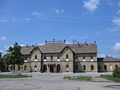
railway station

Traditional German house


Economy and Infrastructure
Jimbolia is a border station with Serbia ; Two pairs of trains run to Kikinda daily . From here the Hatzfeld Railway ran to Zrenjanin in Serbia until 1968 .
Personalities
- Karl Kraushaar (1858–1938), educator, journalist, non-fiction author and banker
- Stefan Jäger (1877–1962), painter
- Peter Jung (1887–1966), journalist and poet
- Peter Heinrich (1890–1944), politician and member of parliament
- Alexander Krischan (1921–2009), historian
- Uwe Detemple (* 1963), author, publicist and poet
- Herbert-Werner Mühlroth (* 1963), publicist and translator
See also
literature
- Hans Vastag, Johann Vastag: Articles in the Heimatblatt Hatzfeld; Monografia orașului Jimbolia 1995
- Anton P. Petri (Ed.): Home book of the heather town Hatzfeld in the Banat . Marquartstein 1991.
- Hans-Werner Krutsch, Hildegard Neidenbach, / Robert Kaiser: Hatzfeld in words and pictures . Nuremberg 1990.
- Alexander Krischan: 200 years of Hatzfeld im Banat 1766–1966 , Stuttgart 1972.
- Elke Hoffmann, Peter-Dietmar Leber and Walter Wolf : The Banat and the Banat Swabians . Volume 5: Cities and Villages . Mediengruppe Universal Grafische Betriebe, Munich 2011, ISBN 3-922979-63-7 , 670 pages.
Web links
Individual evidence
- ↑ 2011 census in Romania at citypopulation.de
- ↑ Mayoral elections 2016 in Romania ( MS Excel ; 256 kB)
- ↑ Swantje Volkmann : The architecture of the 18th century in the Temescher Banat , Heidelberg 2001, uni-heidelberg.de (PDF)
- ↑ Carl Freiherr von Czoernig: Statistical handbook for the Austrian monarchy . 1861, p. 2
- ↑ Erdély etnikai és felekezeti statisztikája
- ↑ Recensamant 2001
