Long Rhön
| Long Rhön | ||
|---|---|---|
|
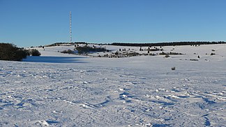
View from the plateau at the Hohen Dalle to the northwest to the Heidelstein |
||
| Highest peak | Heidelstein ( 926 m above sea level ) | |
| location | District of Fulda , Hesse , District of Rhön-Grabfeld , Bavaria , District of Schmalkalden-Meiningen , Thuringia ( Germany ) | |
| Central part of the | Hohen Rhön , Rhön | |
|
|
||
| Coordinates | 50 ° 28 ′ N , 10 ° 0 ′ E | |
As Lange Rhoen a ridge which is central Rhon referred to, in turn, the High Rhön as part of the Rhon is subordinate. The Lange Rhön is an elongated basalt plateau, on average around 800 meters above sea level, its highest point is the Heidelstein at 926 m above sea level. NHN . The vast majority of the area is designated as the Lange Rhön nature reserve. This also includes the Black Moor in the north , near the border triangle Hesse-Thuringia-Bavaria.
Natural allocation
The name Lange Rhön was defined as a natural area in 1968 as part of the natural spatial structure ( M = 1: 200,000) and assigned as follows:
- (to 35 East Hessian mountains )
- (to 354 Hohe Rhön )
- (to 354.1 Rhön headquarters)
- 354.11 Long Rhön
- (to 354.1 Rhön headquarters)
- (to 354 Hohe Rhön )
Demarcation
The 600-meter contour line can roughly be used to demarcate the Langen Rhön in the west from the Upper Ulstertal between Hilders and the Ulsterquelle . The federal road 278 or an imaginary line separates the Wasserkuppenrhön a few hundred meters west to about the height of the Rhönhaus . In the south and east of the area, setting off the eastern slope of the Langen Rhön , the tree line is to be assumed to the Rhönkopf , then an imaginary line in a north-northeast direction to the L1123 near Reichenhausen. Finally, in the north, in demarcation from the Auersberger Kuppenrhön , the 600-meter contour line is used again and the book screen is circled.
geology
The rock of the Langen Rhön is mostly basalt , due to which the slope is mostly below 6 degrees. Slopes of over 12 degrees can only be observed where solifluction debris has accumulated. The plateau has the shape of a ridge in a north-south direction. This creates the Rhine-Weser watershed .

In the eastern slope of the Langen Rhön, attempts were made to generate some profit by mining tertiary brown coal layers, for example in the area of the Eisgraben , which in the long term was not successful. The black moor with an area of approx. 60 hectares and a height of four to five meters is remarkable. The floors are mostly nutrient-rich Ranker to brown soils with low to high water storage capacity and Pseudogley -Braunerden and Pseudogley with poor water supply to the basalts. Mixed types can be found on the solifluction ceilings. Gleye can be discovered in spring troughs and poorly drained lower slopes .
mountains
-
Heidelstein ( 926 m ; west of Oberelsbach with Heidelstein transmitter )
- Schwabenhimmel ( 912.6 m ; eastern foothills with memorial of the Rhön Club)
- Maihügel ( 775 m ; eastern foothills)
- Münzkopf ( 849 m ; southern outlets )
- Ottilienstein ( 846.4 m ; northwest foothills )
- Hoher Dentschberg ( 777.4 m ; southeastern foothills )
- Schwabenhimmel ( 912.6 m ; eastern foothills with memorial of the Rhön Club)
-
Stirnberg ( 901.9 m ;)
- Huckel ( 829 m ; northeast- north foothills )
- Hangenberg ( 809.1 m ; southeastern foothills )
- Steinkopf (Wüstensachsen) ( 888 m ; nature reserve)
- Hohe Dalle ( 862 m ;)
-
Schnitzersberg ( 815.5 m ; highest mountain in the Thuringian Rhön)
-
Ellenbogen (Rhön) ( 813 m ; northern foothills, Rhönklubhaus Eisenacher Haus)
-
Schafküppel ( 806.8 m ; northern foothills)
- Weidberg ( 724.9 m ;)
- Steinköpfchen ( 738.1 m ; north-northeast foothills of the elbow)
-
Schafküppel ( 806.8 m ; northern foothills)
- Book umbrella ( 745.2 m ; western foothills with viewing platform)
- Espenhauck ( 664.6 m ; western foothills)
-
Ellenbogen (Rhön) ( 813 m ; northern foothills, Rhönklubhaus Eisenacher Haus)
-
Querenberg (Rhön) ( 804.8 m ;)
- Rhönhof ( 794.1 m ; eastern foothills; unnamed summit)
- Bloßberg ( 743.3 m ; eastern foothills)
- Grabenberg (Rhön) ( 796.2 m ; location of a former border tower of the GDR )
- Ilmenberg ( 787.1 m ; ski area at the Thüringer Hütte)
- Rhönkopf ( 779.7 m , also known as Salkenberg or "Heimatblick" after the memorial site for GDR refugees )
- Dungberg ( 772.7 m ;)
Climate and vegetation
The climate of Frankenheim is given in 1969 with the following values: 940 mm precipitation, approx. 125 foggy days per year, 5.1 ° C annual average. Centuries of deforestation have created a barren meadow landscape on the Langen Rhön. It was not until 1815 that reforestation began. Over 80% are agricultural land.
Web links
- Long Rhön . In: biosphaerenreservat-rhoen.de
- Long Rhön . In: rhoen.info
- Information center Haus der Langen Rhön
Individual evidence
- ↑ a b c d Werner Röll: Geographical land survey: The natural space units on sheet 126 Fulda - Federal Institute for Regional Studies, Bad Godesberg, 1969 → Natural space map (PDF, 4 MB)
- ↑ Brigitte Schwenzer: Geographical land survey: The natural space units on sheet 140 Schweinfurt - Federal Institute for Regional Studies, Bad Godesberg, 1968 → Natural space map (PDF, 4 MB)


