
Rhön weather extremes
The Rhön weather extremes illustrate the harsh climate of the Rhön low mountain range . These have been documented by the German Weather Service (DWD) at the Wasserkuppe (921 m) weather station since 1936, and the station itself has existed since 1922.
Unless otherwise stated, all of the following information relates to this station. (As of January 2020)
| Long-term annual mean values in the Rhön (measured by the Wasserkuppe (921 m) weather station of the DWD) |
|
|---|---|
| Temperature : | 4.8 ° C |
| Humidity : | 84.6% |
| Frost days : | 142.9 |
| Ice days : | 70.1 |
| Summer days : | 3.0 |
| Days with thunderstorms : | 29.2 |
| Foggy days : | 260.8 |
| Precipitation : | 1083.8 mm |
|
Wind speed : monthly mean |
6.2 m / s (22.3 km / h) |
| Sunshine duration : | 1552.2 h |
temperature
-Deutschland-metrisch-deutsch.png)
The height of the Wasserkuppe at 950 m explains the low temperatures . The absolute temperature fluctuates between 33.0 ° C on July 25, 2019 (heat record) and -26.3 ° C on February 1, 1956 (cold record). The nocturnal minimum temperature at a height of 5 cm was between 18.3 ° C on August 1, 1983 and −27.9 ° C on February 1, 1956. This February 1, 1956 was an extremely severe ice day , the temperature only rose to −22 ° C.
In the long-term temperature series there was a maximum monthly mean of 19.0 ° C in July 2006 and a minimum monthly mean of −12.5 ° C in February 1956. The warmest year (maximum annual mean) was measured in 2018 with 7.4 ° C, the coldest (minimum annual mean) was 1956 with 3.3 ° C.
The long-term mean (1961-1990) is 4.8 ° C and is 3.2 degrees below that of Fulda (273 m) . Since 2011 the annual mean values in the Rhön have been between 0.4 and 2.6 degrees above this long-term mean.
Precipitation
| Average total snow depth on the Wasserkuppe 1947 - 2016 in cm |
||||||
|---|---|---|---|---|---|---|
| Oct | Nov | Dec | Jan | Feb | Mar | Apr |
| 0.3 | 3.8 | 12.8 | 20.4 | 26.3 | 15.9 | 2.8 |
The amount of precipitation is also subject to great fluctuations. The record value of 95.6 mm was measured on July 25, 2017, the highest monthly rainfall fell with 308 mm in October 1923. The year 1965 was the wettest year so far with 1535.7 mm, in the driest year 1976, however, only 661.7 fell mm.
The long-term annual mean is 1,083.8 mm.
snow

At the end of March 1966, a total of 95 cm of fresh snow fell in the high elevations of the Rhön , with 31 March 1966 alone bringing 47 cm, which is still the highest amount of snow that has fallen in 24 hours. From February 2nd to 3rd, 2010, 40 cm of fresh snow fell within one day. The highest snow depth on the Christmas holidays was reached in 1981 with 1.10 m. The maximum snow depth of 1.47 m dates from March 15, 1988.
The start dates of the first and last snowfall show relatively large fluctuations: the earliest snowfall was observed on August 30, 2010, the latest on June 16, 1971. The earliest closed snow cover in autumn (at least 1 cm high) was on September 30, 1954, the latest in spring was recorded on the morning of May 26, 2013.
Air pressure
The maximum measured air pressure was 934.5 hPa on January 20, 2020, the previous minimum 860.5 hPa on February 26, 1989.
These values must be reduced to sea level using the barometric altitude formula . Based on the temperature and humidity values measured simultaneously, this corresponds to a maximum of 1048.9 hPa and a minimum of 964.9 hPa for the Wasserkuppe station.
wind
The maximum wind speed of 47.8 m / s (172.1 km / h) was measured on January 18, 2007 during the passage of hurricane Kyrill and exceeded the previous high of 44 m / s (158.4 km / h) from February 12, 1962. The average monthly wind speed fluctuates between 3.15 m / s (11.3 km / h) in the windless May 1960 and 10.59 m / s (38.1 km / h) in the windy February 2002.
The mean monthly mean is 6.2 m / s (22.3 km / h).
Sunshine duration
The sunniest month so far was May 1989 with 329.7 hours, the dullest December 1993 with only 1.9 hours.
It was the sunniest in 1959 with a total of 2173.1 hours, whereas in 1998 the sun shone for only 1304.5 hours.
The long-term mean is 1,552.2 hours.
storm

The geographical location of the Rhön plays a special role here. The Vogelsberg divides the weather fronts into two main regions. Western storm fronts load up over the Wetterau and the Taunus and move either over the southern Vogelsberg and the land ridge ( Flieden , Heubach, Bad Brückenau ) or in the north over Lauterbach and the Hünstelder Land (Michelsrombach, Eiterfeld ). The district of Fulda is directly affected when storms build up coming from the east.
The following examples document outstanding historical weather events.
Eisgraben on July 26, 1834
The Aschelbach on the Hochrhön later forms the Eisgraben, which was given its current shape by a cloudburst on the Hochrhön on July 26, 1834. The masses of water and the debris and rocks carried along caused great damage in Hausen . In Eisgraben this also lignite deposits have been uncovered, but they are for a worthwhile reduction too young. The mining was stopped twice, most recently after the Second World War.
Simmershausen on August 14, 1955
The Simmershausen Chronicle reports on a storm on August 14, 1955, which devastated the whole place:
During the high mass a downpour broke out in our village and the corridor and lasted until the afternoon. It wasn't until 3:00 p.m. that we could see what damage the water had caused. The water masses had torn holes in the street that were several meters in size. Stone rubble, mud and deep trenches could be seen everywhere in the village and in the hallway.
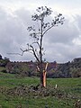
Moths on October 22, 2005
On October 22, 2005 (19: 22–19: 29 CET) a category T6 / F3 tornado devastated a piece of forest near Motten and caused damage to the industrial park there. In a few seconds it had drawn a swath of devastation. In the valley, two birches were turned off by the tornado at a height of 1.70 m (torsion) and transported up to 70 m on the left. Heat-insulating roof construction parts were transported up to 6.59 km. The primary aisle width was 182 m, the secondary area of the tornado was measured at 298 m. The damage track was measured at 7.12 km, which led from Motten over the "Hohe Kammer" to Gichenbach.
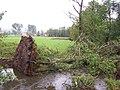
Diedorf on October 1, 2006
The tornado in the Diedorf case occurred shortly before midnight on the Hesse-Thuringia border. The development phase extended from the "Neue Wiese", "Struth" and "Schartwiese" still in the Tann / Rhön area across the state border to the southeast slope of the Horbel mountain. The first damage showed up here on the Hessian side in the form of twisted and thrown spruce trees [30 m³], 3 thrown poplars and a high seat. Further to the north-east in the Thuringia area, there was also slight previous damage and on the south-east slope of the Horbel mountain there was actually strong tornado ground contact and the further funnel reinforcement in a beech stand [186 m × 152 m]. The trail of damage extended over a length of 8 km to Rossberg. The tornado strength was measured using damage categories T4 / F2. In the Diedorf area, damage was found in the T3 / F1 area [151-170 km / h]. The approximately 15 m high village linden was uprooted and buried a car under it. 50% of the roofs were damaged. In the forest area of Horbel near Empfertshausen, as well as in the lower middle of the valley on the Horbel, the strongest litter and splinter damage was found in the upper T4 area. This corresponds to a wind speed of approx. 218 km / h. Here 92 percent of the beech population was overturned on an area of approx. 5 ha. The few trees that were still standing were partly torn open and threatened to topple over.
- Tornado in Diedorf


swell
- ↑ Geoclimate 2.1
- Public notice of the "Wasserkuppe" weather station of the German Weather Service (DWD) .
- 1075 years Hilders and Simmershausen, review of the local history in individual contributions. Publishing house Parzeller GmbH & Co KG, Fulda; ISBN 3-7900-0195-3
- Dr. Martin Gudd: " Thunderstorms and thunderstorm damage in the southern Hessian mountain and basin region and in the Rhine-Main lowlands from 1881 to 1980 "