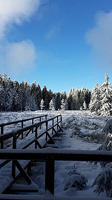
Schützenbergmoor
The Schützenbergmoor is located in the Schmalkalden-Meiningen district in Thuringia on a hiking trail between Rondell near Oberhof via Stein 16 , Adelsruh to Zella-Mehlis . It has been a nature reserve since 1967 , which was reconstructed in 2012 with a path made of wooden planks and made accessible.
The moor area covers approx. 5.21 hectares . The greatest thickness of the bog is 2.5 meters. It is one of the so-called raised bogs (according to the information board on the bog).
Geography and climate
The moor lies at an altitude of 890 m above sea level. NHN. Every year there is about 1,230 millimeters of precipitation and the annual mean temperature is 5 ° C. On average there are 180 days of fog per year in the Schützenbergmoor.
Flora and fauna
Plants typical of bog such as peat moss , cranberry , round-leaved sundew and cotton grass grow in the area. The dwarf shrew and earth mouse , as well as forest lizards and common frogs inhabit the moor.
See also
Web links
- mdr.de: "Schützenbergmoor" educational trail reopened ( Memento from June 17, 2013 in the Internet Archive )
- World Database on Protected Areas - Schützenbergmoor (English)
- Nature reserves (status: 03/2018) - Schmalkalden-Meiningen district on tlug-jena.de, accessed on February 22, 2019
Individual evidence
- ↑ Out and about on the Moorsteg - Schützenbergmoor made tangible for visitors. UNESCO Biosphere Reserve Thuringian Forest, accessed on March 7, 2019 .
Coordinates: 50 ° 41 ′ 41.7 ″ N , 10 ° 41 ′ 55.9 ″ E ,


