Flea Seligenthal
| coat of arms | Germany map | |
|---|---|---|
|
Coordinates: 50 ° 46 ' N , 10 ° 29' E |
|
| Basic data | ||
| State : | Thuringia | |
| County : | Schmalkalden-Meiningen | |
| Height : | 370 m above sea level NHN | |
| Area : | 68.71 km 2 | |
| Residents: | 5889 (Dec. 31, 2019) | |
| Population density : | 86 inhabitants per km 2 | |
| Postal code : | 98593 | |
| Primaries : | 03683, 036849 | |
| License plate : | SM, MGN | |
| Community key : | 16 0 66 023 | |
| LOCODE : | DE FHH | |
| Community structure: | 6 districts | |
| Address of the municipal administration: |
Bahnhofstrasse 4 98593 Floh-Seligenthal |
|
| Website : | ||
| Mayor : | Ralf Holland-Nell ( CDU ) | |
| Location of the municipality of Floh-Seligenthal in the district of Schmalkalden-Meiningen | ||
Floh-Seligenthal is a unified municipality in the district of Schmalkalden-Meiningen in the southwest of the Free State of Thuringia .
geography
Geographical location
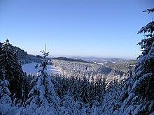
Floh-Seligenthal is located in the north of the Schmalkalden-Meiningen district on the southwest slope of the Thuringian Forest, directly on the Rennsteig . The absolute height of the local locations fluctuates between 340 m above sea level. NN and 480 m above sea level NN. The community is located on the upper reaches of the Schmalkalde River . The mountains facing the Rennsteig have heights of over 800 m above sea level. NN and are easily accessible via an extensive network of hiking trails. At about 780 m above sea level. NN is the mountain lake Ebertswiese, which is well known far beyond the region.
Neighboring communities are Brotterode-Trusetal , Fambach , Schmalkalden , Steinbach-Hallenberg and Tambach-Dietharz , Georgenthal , Friedrichroda and Tabarz .
Community structure
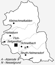
The community has six districts: Floh , Seligenthal (with the hamlet of Atzerode ), Hohleborn , Kleinschmalkalden , Schnellbach (with the hamlet of Nesselhof ) and Struth-Helmershof .
language
Floh-Seligenthal is located on the Rennsteig and thus on a distinctive language border. On the south-western side of the Rennsteig, the region around Floh-Seligenthal speaks Hennebergisch , an East Franconian dialect . In the towns of Friedrichroda and Tambach-Dietharz , just a few kilometers beyond the Rennsteig, the central Thuringian language is a completely foreign dialect.
history
The old Franconian settlements, which developed into small forest villages in the Middle Ages, were first mentioned in a document by the Counts of Henneberg in the course of the 14th century .
Escaped
The place Floh appears for the first time in 1340 as "Flo" in a Henneberg property register. The place name goes back to the Middle High German word vlowe (wash, rinse), which also gave the Flohbach its name. There are reports, but no documents, about a falcon castle in the vicinity of Flea. Traces on a steep boulder indicate a core castle with a high rampart and a ditch in front. Within this area, pits can be interpreted as the basement of buildings.
There were three major fires in Flea (1895, 1902, 1903). A total of over 420 houses, mainly Franconian half-timbered houses, were destroyed.
Schnellbach with the hamlet of Nesselhof
The village formerly known as "Sneylbach" was first mentioned in 1340. However, it is relatively certain that the settlement existed before. As early as 1290, records were made about a hospice "Sankt Nikolaus" at the Nesselhof.
The name Schnellbach apparently comes from the Fleabach, which flows quickly through the valley. This broke its banks in the summer of 1981 during a heavy downpour and caused a state of emergency in the village and the communities further downstream. Numerous cellars were flooded and the cobblestone relief of the main street was completely destroyed.
Struth-Helmershof
Struth and Helmershof were originally two separate rural communities until they were united in 1936. The first written mention of the Struth dates from 1340. The Helmershof was once a free aristocratic estate around which a small village developed and later came into the possession of the city of Schmalkalden, before it was merged with the Struth to Struth-Helmershof in 1936.
On January 1, 1996 Struth-Helmershof was incorporated into Floh-Seligenthal.
Seligenthal with the hamlet of Atzerode
The first written mention of Seligenthal comes from October 16, 1320. The document is a letter of purchase in which a certain Wolfram Schrimpf leaves Count Berthold von Henneberg several goods, including "Selgenthal".
But mining settlements apparently existed here a long time before. The importance of mining for the development of the entire region was great. With the emergence of several iron smelting furnaces, Zain and wire hammers, iron and steel goods production became the livelihood of the inhabitants for centuries. Up until the second half of the 20th century, high-quality iron ore was mined in the “Stahlberg” mine in Atzerode . The subsequent river and barite mining, which was carried out until the beginning of the 1990s, still shapes the landscape in and around Atzerode today.
During the Thirty Years War Seligenthal was attacked, looted and burned down to 3 houses in 1636.
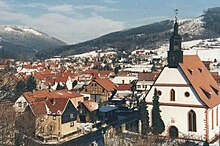
Between 1687 and 1698 a baroque church was built in Seligenthal , which is adorned with numerous paintings on the ceiling and galleries.
Hohleborn
Hohleborn was first mentioned in a document in 1340. The place belonged to the office of Schmalkalden of the Hessian rule Schmalkalden .
Hohleborn has been part of the Floh-Seligenthal community since June 1, 1994.
Kleinschmalkalden
Kleinschmalkalden was first mentioned in a document in 1378. Kleinschmalkalden was divided over centuries: The part to the west of the Schmalkalde was first mentioned in 1465 and belonged to the Amt of Brotterode in the rule of Schmalkalden , an exclave of the Landgraviate of Hessen-Kassel (from 1866 to Prussia). After 1500 a settlement arose east of the Schmalkalde, which belonged to the Tenneberg Office in the Duchy of Saxony-Gotha (1640-1918) and from 1920 to the Free State of Thuringia. Because of this, there are two Protestant churches in the village: a Hessian and a Gotha church. The two districts were united on October 1, 1945. From 1945 to 1990 the place was called Pappenheim in memory of the politician Ludwig Pappenheim, who was murdered by the National Socialists . On July 27, 1990, the community was renamed Kleinschmalkalden again. Kleinschmalkalden has been part of the Floh-Seligenthal community since February 1, 2006.
The largest cowbell in the world is located in the village. It is approximately 3.28 meters high and weighs 920 kilograms.
Development in the present
The municipality of Floh-Seligenthal emerged from the voluntary amalgamation of the six formerly independent municipalities. After Floh, Seligenthal and Hohleborn merged on June 1, 1994, Struth-Helmershof followed on January 1, 1996. On February 1, 2006, Kleinschmalkalden, the last district, was incorporated.
Schnellbach was incorporated into Flea on May 6, 1993.
Population development
The development of the population is mainly characterized by the incorporation of the Struth-Helmershof district in 1996 and the Kleinschmalkalden district in 2006. These each led to a strong increase in population. Outside of these incorporations, a general trend towards population loss can be observed over the past two decades:
|
|
|
|
|
politics
Municipal council
The council of Floh-Seligenthal has 20 councils and has been composed as follows since the local elections on May 25, 2014:
| FDP : | 7 seats |
| CDU : | 9 seats |
| LEFT : | 2 seats |
| SPD : | 2 seats |
| Debt level: | 0 euros (since 11/2011) |
| Per capita debt: | 0 euros (since 11/2011) |
Ralf Holland-Nell (CDU) was elected as mayor in the runoff election on May 6, 2012.
coat of arms
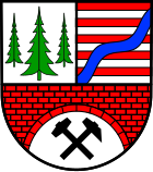
Blazon : The municipal coat of arms is half-split and divided and shows a green spruce in silver at the top, each side with a smaller green spruce; the upper left field is divided nine times by red and silver and covered with a blue oblique left wavy bar; the lower field shows a red brick arch over a crossed black hammer and mallet in silver.
Partnerships
Floh-Seligenthal has partnerships with Châteauneuf-en-Thymerais ( France ) and Körle ( Hesse ).
Economy and Infrastructure
economy
In Floh-Seligenthal there are currently four designated industrial areas with a total area of around 22.5 hectares . The most important industries include metal processing and processing, wood processing, plastics processing, the food and confectionery industry ( Viba ) as well as the main and ancillary construction trades. Many local small and medium-sized companies and craft businesses are the basis of the relatively low unemployment rate, which is mostly below the national average.
education
There is a communal crèche in the Seligenthal district.
There are four kindergartens within the municipality, two of which are municipal kindergartens (districts Seligenthal and Schnellbach), a kindergarten run by the Arbeiter-Samariter-Bund (district Kleinschmalkalden ) and a private day-care center (district Schnellbach).
The district of Floh is home to a state primary school as well as a state regular school, which is attended by the students of the districts.
Sports facilities
In the districts of Floh, Seligenthal and Struth-Helmershof, the lawn sports fields have been modernized in recent years and each equipped with floodlights. There is also a hard court in Struth-Helmershof for training. There is also a hard court with lighting in the Kleinschmalkalden district.
The Struth-Helmershof mountain swimming pool was also modernized between 1995 and 1996, and now has a stainless steel pool, a slide and solar heating.
traffic
Floh-Seligenthal station was on the Schmalkalden – Brotterode railway line . Passenger traffic was discontinued in 1996. This route is now closed and functions as the Mommelstein-Bahnradweg . Coming from Schmalkalden (approx. 3 km away), the L1026 runs through the village and leads via Kleinschmalkalden (approx. 4 km away) to Friedrichroda (approx. 16 km away). Branch off in the village:
- the L1028, via Nesselhof (approx. 6 km away) to Tambach-Dietharz (approx. 12 km away) and Ohrdruf (approx. 24 km away).
- the L1117, via Struth-Helmershof (approx. 2 km away) to Steinbach-Hallenberg (approx. 11 km away)
- the L1126, to Brotterode-Trusetal (approx. 7 km away)
Culture and sights
Floh-Seligenthal has been a "state-approved resort " since 2000 . Not far from Seligenthal are the remains of the prehistoric Falkenburg Castle .
Personalities
- The cantor and composer Johann Michael Bach III was born on November 9, 1745 in Struth .
- Organist and composer Johann Caspar Simon was born on January 10, 1701 in Floh .
- The former Minister for Construction and Transport of the Free State of Thuringia, Andreas Trautvetter , was born on September 21, 1955 in what was then Pappenheim .
- The municipality of Floh-Seligenthal is home to several successful winter sports enthusiasts. Carola Anding , a former German cross-country skier , was born on December 29, 1960 in the Struth-Helmershof district . The cross-country skier Gerhard Grimmer , the cross-country skier Carola Jacob and the biathlete Matthias Jacob live here . The biathlete Frank Luck grew up in the Seligenthal district . The bobsledder René Hoppe lives in Struth-Helmershof. The biathlete Juliane Döll comes from Flea . The biathlete Sven Fischer also lives in Seligenthal .
- The FDP politician and member of the German Bundestag Gerald Ullrich lives in Floh-Seligenthal.
Individual evidence
- ^ Population of the municipalities from the Thuringian State Office for Statistics ( help on this ).
- ↑ Thomas Bienert: Medieval castles in Thuringia. 430 castles, castle ruins and fortifications. Wartberg Verlag, Gudensberg-Gleichen 2000, ISBN 3-86134-631-1 , p. 252.
- ↑ a b StBA: Changes in the municipalities in Germany, see 1996
- ^ Wolfgang Kahl : First mention of Thuringian towns and villages. A manual. 5th, improved and considerably enlarged edition. Rockstuhl, Bad Langensalza 2010, ISBN 978-3-86777-202-0 , p. 253.
- ↑ archive-in-thueringen.de
- ↑ a b Federal Statistical Office (ed.): Municipalities 1994 and their changes since 01.01.1948 in the new federal states . Metzler-Poeschel, Stuttgart 1995, ISBN 3-8246-0321-7 .
- ↑ StBA: Changes in the municipalities in Germany, see 2006 .
- ↑ kleinschmalkalden.de .
- ↑ StBA: Changes in the municipalities in Germany, see 1994
- ↑ StBA: Changes in the municipalities in Germany, see 2006
- ↑ Population figures for the municipality: Floh-Seligenthal .
- ↑ Large community today sets the debt clock to zero .
- ^ Floh-Seligenthal largest debt-free municipality
- ↑ CDU leaves feathers in runoff elections. insuedthueringen.de from May 6, 2012.
- ↑ Partner communities on the Floh-Seligenthal website


