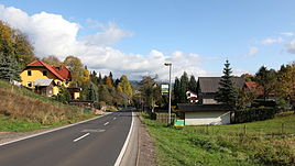
Atzerode
|
Atzerode
Community flea Seligenthal
Coordinates: 50 ° 46 ′ 1 ″ N , 10 ° 27 ′ 31 ″ E
|
|
|---|---|
| Height : | 400 m above sea level NN |
| Postal code : | 98593 |
| Area code : | 03683 |
Atzerode is a district of Floh-Seligenthal in the Schmalkalden-Meiningen district in Thuringia .
location
The Atzerode district is located on Landesstraße 1126 above the Stahlberg mine in a mountainous and open south-facing slope with a winding mountain road in the Thuringian Forest .
history
The mountain village was first mentioned on October 16, 1320. It belonged to the office of Schmalkalden of the Hessian rule Schmalkalden .
Until the second half of the 20th century, iron ore was mined in the Stahlberg mine in Atzerode. The subsequent mining of fluorspar and barite still shapes the landscape today.
Web links
Commons : Atzerode - collection of images, videos and audio files
Individual evidence
- ^ Wolfgang Kahl : First mention of Thuringian towns and villages. A manual. 5th, improved and considerably enlarged edition. Rockstuhl, Bad Langensalza 2010, ISBN 978-3-86777-202-0 , p. 21.
