
Administrative division of Berlin
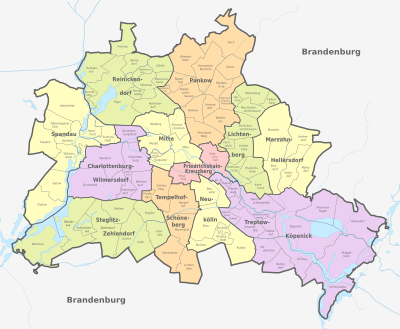
The current administrative structure of Berlin has existed since January 1, 2001, when Berlin was divided into twelve districts through an administrative reform , which have the function of administrative districts and form the lower part of the two-tier public administration .
According to Article 66, Paragraph 2 of the Berlin Constitution , the districts fulfill their tasks according to the principles of self-administration. The district administrations are primarily responsible for matters on site in the districts, such as culture, green spaces or schools. The districts are divided into 96 districts .
General
The district self-government has constitutional status (Articles 68–77 of the Berlin Constitution ). It is divided into two administrative bodies, the District Assembly (BVV) and the District Office (BA). BVV than directly by the inhabitants of the district elected representatives ( parliament ) of the "parliamentary" part, the district office leads the administration. Each district office consists of the district mayor (full-time, paid according to the B6 federal salary regulations ) and four district councilors (paid according to the B4 federal salary regulations ). The districts of Berlin can only be roughly compared with rural districts in terms of population . Since the state of Berlin as a city-state is a unified municipality , there is no administrative level of the district in Berlin. The districts are not independent local authorities with their own legal personality - they do not even have the status of a municipality . Rather, it is a matter of “self-governing units in Berlin without legal personality” (Section 2 (1) of the District Administration Act).
With the 8th law amending the District Administration Act of October 22, 2008, which came into force at the beginning of the 17th electoral term, all district offices were uniformly divided into the same structures of the specialist offices. Various old specialist offices were combined to form larger organizational units; there should then only be ten specialist offices per district administration.
In addition to the subdivision into districts, there is a small-scale breakdown of the Berlin districts into 195 statistical areas, which are marked with three-digit numbers. One such statistical area is, for example, the Bavarian Quarter in Schöneberg , where the streets are mainly named after cities in Bavaria . The statistical areas roughly correspond to the localities or the residential areas ( Kiez ). You can reach across district boundaries; in such cases it is not possible to clearly assign a statistical area to a specific district. For example, the Rudow statistical area is partly located in the Rudow district and partly in the Gropiusstadt district .
Districts of Berlin

|
Population density of the individual districts of Berlin (as of December 31, 2019) |
||||
|---|---|---|---|---|
| district | Inhabitant per km² | |||
| Friedrichshain-Kreuzberg | 14,404 | |||
| center | 9,773 | |||
| Neukölln | 7,343 | |||
| Tempelhof-Schöneberg | 6,611 | |||
| Lichtenberg | 5,626 | |||
| Charlottenburg-Wilmersdorf | 5,309 | |||
| Marzahn-Hellersdorf | 4,373 | |||
| Pankow | 3,974 | |||
| Steglitz-Zehlendorf | 3,025 | |||
| Reinickendorf | 2,978 | |||
| Spandau | 2,668 | |||
| Treptow-Koepenick | 1,625 | |||
Up until the year 2000 there were 23 districts in Berlin. In the course of the last administrative reform (district area reform ) in 2001, the number was reduced to twelve by merging two or three districts. Spandau , Reinickendorf and Neukölln , which already had over 200,000 inhabitants, were excluded from the district merger .


Subdivision of the districts into districts
The subdivision of the administrative districts into districts is based on the Greater Berlin Act of 1920 , which is still in force :
- Section 29, Paragraph 1: "By a unanimous resolution of the district assembly and the district office, an administrative district can be divided into local districts (Section 60 of the City Code) with the approval of the magistrate."
Only the terminology has changed as a result of the Berlin constitution: District Assembly (instead of District Assembly); Senate (instead of magistrate) and districts (instead of local districts). The Berlin statistics are based on the specifications of the districts in their information about districts.
According to the Greater Berlin Act, the previous rural and urban communities became districts. If old communities were divided by the new district boundaries, corresponding districts were created for the individual parts. The district of Charlottenburg, which emerged from the city of Charlottenburg, was the only district that emerged from a single city without subdivision into districts, while the Friedrichshain district was the only " old Berlin " district with districts (Friedrichshain and Stralau ).
Over the years, there have been repeated changes to the district boundaries, smaller districts were dissolved and newly created settlements removed from existing districts (even if often only years later). There were major waves of change in the context of the district reform in 1938, in the early 1950s and as a result of the formation of the new large districts between 2001 and 2004.
From 1965 onwards, no districts were designated in East Berlin , and when the new districts were formed from 1979 onwards, no consideration was given to the former district boundaries. Only after reunification were the old districts re-established - adapted to the changed district boundaries - this led to the special situation that the Malchow district existed twice - in the Hohenschönhausen district as well as in the Weißensee district . The latter was then renamed in 2001 in the suburb of Malchow .
In the districts established in 1920, the settlement structure of the villages that emerged in the Middle Ages was essentially reflected. Several of the changes since 2001 react pragmatically to the massive construction of new apartments in the context of high-rise housing estates between 1961 and 1989. In West Berlin, this applies not only to the Hansaviertel (1960), but also to the Gropiusstadt and the Märkisches Viertel . The more extensive new construction activity in East Berlin, on the other hand, had led to the formation of new districts since the late 1970s (Marzahn, Hellersdorf, Hohenschönhausen). In 2012, Borsigwalde , previously located in Wittenau , was declared an independent district of the Reinickendorf district and thus the 96th district of Berlin.
| No. | District |
district |
Area (km²) |
Population (December 31, 2019) |
Inhabitants per km² |
|---|---|---|---|---|---|
| 101 | center | center | 10.70 | 102,465 | 9576 |
| 102 | Moabit | center | 7.72 | 80,495 | 10,427 |
| 103 | Hansaviertel | center | 0.53 | 5,926 | 11,181 |
| 104 | Zoo | center | 5.17 | 14,881 | 2878 |
| 105 | Wedding | center | 9.23 | 86,806 | 9405 |
| 106 | Healthy well | center | 6.13 | 95,175 | 15,526 |
| 201 | Friedrichshain | Friedrichshain-Kreuzberg | 9.78 | 136.035 | 13,910 |
| 202 | Kreuzberg | Friedrichshain-Kreuzberg | 10.40 | 154.351 | 14,841 |
| 301 | Prenzlauer Berg | Pankow | 11.00 | 165.003 | 15,000 |
| 302 | Weissensee | Pankow | 7.93 | 54.032 | 6814 |
| 303 | Blankenburg | Pankow | 6.03 | 6,875 | 1140 |
| 304 | Heinersdorf | Pankow | 3.95 | 7,869 | 1992 |
| 305 | Karow | Pankow | 6.65 | 19,679 | 2959 |
| 306 | Malchow suburb | Pankow | 5.68 | 1,120 | 197.2 |
| 307 | Pankow | Pankow | 5.66 | 64,945 | 11,474 |
| 308 | Blankenfelde | Pankow | 13.40 | 2,064 | 154 |
| 309 | book | Pankow | 18.20 | 16,868 | 926.8 |
| 310 | French Buchholz | Pankow | 12.00 | 21,281 | 1773 |
| 311 | Niederschönhausen | Pankow | 6.49 | 31,996 | 4930 |
| 312 | Rosenthal | Pankow | 4.90 | 9,596 | 1958 |
| 313 | Wilhelmsruh | Pankow | 1.37 | 8.007 | 5845 |
| 401 | Charlottenburg | Charlottenburg-Wilmersdorf | 10.60 | 130,663 | 12,327 |
| 402 | Wilmersdorf | Charlottenburg-Wilmersdorf | 7.16 | 102,619 | 14,332 |
| 403 | Schmargendorf | Charlottenburg-Wilmersdorf | 3.59 | 22.205 | 6185 |
| 404 | Grunewald | Charlottenburg-Wilmersdorf | 22.30 | 10,999 | 493.2 |
| 405 | West end | Charlottenburg-Wilmersdorf | 13.50 | 41,882 | 3102 |
| 406 | Charlottenburg-North | Charlottenburg-Wilmersdorf | 6.20 | 19,597 | 3161 |
| 407 | Halensee | Charlottenburg-Wilmersdorf | 1.27 | 15,627 | 12.305 |
| 501 | Spandau | Spandau | 8.03 | 39,560 | 4927 |
| 502 | Haselhorst | Spandau | 4.73 | 15,663 | 3311 |
| 503 | Siemensstadt | Spandau | 5.66 | 12,831 | 2267 |
| 504 | Staaken | Spandau | 10.90 | 46,607 | 4276 |
| 505 | Gatow | Spandau | 10.10 | 3,733 | 369.6 |
| 506 | Kladow | Spandau | 14.80 | 16,212 | 1095 |
| 507 | Hook field | Spandau | 20.40 | 31,296 | 1534 |
| 508 | Falkenhagener Feld | Spandau | 6.88 | 38,759 | 5634 |
| 509 | Wilhelmstadt | Spandau | 10.40 | 40,536 | 3898 |
| 601 | Steglitz | Steglitz-Zehlendorf | 6.79 | 75,803 | 11,164 |
| 602 | Lichterfelde | Steglitz-Zehlendorf | 18.20 | 86.206 | 4737 |
| 603 | Lankwitz | Steglitz-Zehlendorf | 6.99 | 43,566 | 6233 |
| 604 | Zehlendorf | Steglitz-Zehlendorf | 18.80 | 60,538 | 3220 |
| 605 | Dahlem | Steglitz-Zehlendorf | 8.39 | 16,929 | 2018 |
| 606 | Nikolassee | Steglitz-Zehlendorf | 19.60 | 16,695 | 851.8 |
| 607 | Wannsee | Steglitz-Zehlendorf | 23.70 | 10,334 | 436 |
| 701 | Schöneberg | Tempelhof-Schöneberg | 10.60 | 123.075 | 11,611 |
| 702 | Friedenau | Tempelhof-Schöneberg | 1.65 | 28,263 | 17.129 |
| 703 | Tempelhof | Tempelhof-Schöneberg | 12.20 | 62,248 | 5102 |
| 704 | Mariendorf | Tempelhof-Schöneberg | 9.38 | 53.094 | 5660 |
| 705 | Marienfelde | Tempelhof-Schöneberg | 9.15 | 32,349 | 3535 |
| 706 | Lichtenrade | Tempelhof-Schöneberg | 10.10 | 51,955 | 5144 |
| 801 | Neukölln | Neukölln | 11.70 | 166.157 | 14,201 |
| 802 | Britz | Neukölln | 12.40 | 42,796 | 3451 |
| 803 | Buckow | Neukölln | 6.35 | 40,703 | 6410 |
| 804 | Rudow | Neukölln | 11.80 | 42,631 | 3613 |
| 805 | Gropiusstadt | Neukölln | 2.66 | 37,630 | 14,147 |
| 901 | Alt-Treptow | Treptow-Koepenick | 2.31 | 12,878 | 5575 |
| 902 | Plänterwald | Treptow-Koepenick | 3.01 | 11,365 | 3776 |
| 903 | Baumschulenweg | Treptow-Koepenick | 4.82 | 18,842 | 3909 |
| 904 | Johannisthal | Treptow-Koepenick | 6.54 | 19,853 | 3036 |
| 905 | Niederschöneweide | Treptow-Koepenick | 3.49 | 12,850 | 3682 |
| 906 | Altglienicke | Treptow-Koepenick | 7.89 | 29,357 | 3721 |
| 907 | Adlershof | Treptow-Koepenick | 6.11 | 19,934 | 3263 |
| 908 | Bohnsdorf | Treptow-Koepenick | 6.52 | 11,671 | 1790 |
| 909 | Oberschöneweide | Treptow-Koepenick | 6.18 | 23,500 | 3803 |
| 910 | Koepenick | Treptow-Koepenick | 34.90 | 66,765 | 1913 |
| 911 | Friedrichshagen | Treptow-Koepenick | 14.00 | 19,145 | 1368 |
| 912 | Rahnsdorf | Treptow-Koepenick | 21.50 | 9,523 | 442.9 |
| 913 | Grünau | Treptow-Koepenick | 9.13 | 6,784 | 743 |
| 914 | Müggelheim | Treptow-Koepenick | 22.20 | 6,798 | 306.2 |
| 915 | Schmoeckwitz | Treptow-Koepenick | 17.10 | 4,424 | 258.7 |
| 1001 | Marzahn | Marzahn-Hellersdorf | 19.50 | 111.021 | 5693 |
| 1002 | Biesdorf | Marzahn-Hellersdorf | 12.40 | 28,069 | 2264 |
| 1003 | Kaulsdorf | Marzahn-Hellersdorf | 8.81 | 19,408 | 2203 |
| 1004 | Mahlsdorf | Marzahn-Hellersdorf | 12.90 | 29,360 | 2276 |
| 1005 | Hellersdorf | Marzahn-Hellersdorf | 8.10 | 82,109 | 10.137 |
| 1101 | Friedrichsfelde | Lichtenberg | 5.55 | 53,813 | 9696 |
| 1102 | Karlshorst | Lichtenberg | 6.60 | 27,956 | 4236 |
| 1103 | Lichtenberg | Lichtenberg | 7.22 | 41,758 | 5784 |
| 1104 | Falkenberg | Lichtenberg | 3.06 | 1,870 | 611.1 |
| 1106 | Malchow | Lichtenberg | 1.54 | 635 | 412.3 |
| 1107 | Wartenberg | Lichtenberg | 6.92 | 2,548 | 368.2 |
| 1109 | Neu-Hohenschönhausen | Lichtenberg | 5.16 | 56,918 | 11,031 |
| 1110 | Old Hohenschönhausen | Lichtenberg | 9.33 | 48,979 | 5250 |
| 1111 | Fennpfuhl | Lichtenberg | 2.12 | 34,074 | 16,073 |
| 1112 | Rummelsburg | Lichtenberg | 4.52 | 25,650 | 5675 |
| 1201 | Reinickendorf | Reinickendorf | 10.50 | 83.909 | 7991 |
| 1202 | Tegel | Reinickendorf | 33.70 | 36,986 | 1098 |
| 1203 | Konradshöhe | Reinickendorf | 2.20 | 6.004 | 2729 |
| 1204 | Heiligensee | Reinickendorf | 10.70 | 18,100 | 1692 |
| 1205 | Frohnau | Reinickendorf | 7.80 | 16,814 | 2156 |
| 1206 | Hermsdorf | Reinickendorf | 6.10 | 16.607 | 2722 |
| 1207 | Huntsmanship | Reinickendorf | 2.30 | 10,973 | 4771 |
| 1208 | Lübars | Reinickendorf | 5.00 | 5,203 | 1041 |
| 1209 | Wittenau | Reinickendorf | 5.90 | 24,656 | 4179 |
| 1210 | Märkisches Viertel | Reinickendorf | 3.20 | 40,379 | 12,618 |
| 1211 | Borsigwalde | Reinickendorf | 2.00 | 6,777 | 3389 |
History of the urban division of Berlin
.jpg)


The beginnings
In the 13th century both Berlin and Kölln received city rights. As early as 1307 a joint magistrate of the two cities was formed, which were also surrounded by a common city wall . For reasons of power politics, Elector Friedrich II obtained the renewed separation of Berlin and Kölln into two independent cities in 1442. Based on the experiences of the Thirty Years War , the Great Elector Friedrich Wilhelm had a large fortress built from 1658 to 1683 , which included Berlin and Kölln as well as the suburbs of Friedrichswerder in the west and Neu-Kölln in the south. Friedrichswerder received its own magistrate, while Neu-Kölln was administered by Kölln.
Berlin in the 18th century
The building of the fortress proved to be outdated at the time of its completion, because further new suburbs had already emerged outside the ramparts. In 1710 the previously formally independent cities of Berlin, Kölln (with Neu-Kölln), Friedrichswerder, Dorotheenstadt and Friedrichstadt were united to form the royal capital and residence city of Berlin . Together with the other former suburbs included by the customs and excise wall, Berlin consisted of a total of ten districts in the 18th century:
- Berlin
- Kölln
- Friedrichswerder (founded in 1662)
- Neu-Kölln (built on as planned from 1681)
- Dorotheenstadt ( founded as Neustadt in 1674 , Dorotheenstadt from 1681)
- Friedrichstadt (founded in 1691)
- Spandau quarter (until 1701 Spandau suburb )
- Königsstadt (until 1701 Georgenvorstadt )
- Stralauer Viertel (until 1701 Stralauer Vorstadt )
- Köpenicker Viertel (until 1701 Köpenicker Vorstadt, from 1801 Luisenstadt )
Municipal division in the 19th century
The introduction of the Prussian town order as part of the Stein-Hardenberg reforms brought radical changes to the municipal administrative structure of Berlin. The new town order envisaged dividing larger towns into districts with several thousand inhabitants. Berlin was initially divided into a hundred districts, which initially also had their own names; for example, there was the Hallesche-Thor district, the Spittelmarkt district and the Monbijou district.
The number of districts increased over time as the population grew. After the city expansion in 1861, there were 270 districts that no longer had names, but were only numbered consecutively. In 1884 there was a new division into 326 districts, the number of which increased to 328 by the time Greater Berlin was formed in 1920.
The districts were grouped into districts , although there were no significant municipal institutions at the district level. In the course of the 19th century, more were added to the old ten districts. The Friedrich-Wilhelm-Stadt was separated from the Spandau suburb in 1828 and has since formed its own district. In the area of the city expansion from 1829 to 1841, the Rosenthaler and Oranienburger Vorstadt were created in the north and the Friedrichsvorstadt in the southwest .
In 1861, with the incorporation of the Weddings , Gesundbrunnen and Moabit as well as the Tempelhofer and Schöneberger Vorstadt, the most extensive urban expansion to date was carried out. Existing city districts also extended to some of the incorporated areas; so the Luisenstadt, the royal city and the Stralauer Vorstadt grew beyond their old outer borders. The last incorporations before the formation of Greater Berlin included the Great Zoo in 1881, the area of the Central Cattle Farm in 1878 and parts of the Plötzensee manor district and the Rehberge , which were incorporated in 1915.
The following 21 historic districts existed until 1920
- [I] Berlin (spelling also: Alt-Berlin)
- [II] Alt-Kölln
- [III] Friedrichswerder
- [IV] Dorotheenstadt
- [V] Friedrichstadt
- [VI] Lower Friedrichsvorstadt
- [VII] Schöneberger Vorstadt
- [VIII] Upper Friedrichsvorstadt
- [IX] Tempelhof suburb
- [X] Luisenstadt across the canal
- [XI] Luisenstadt this side of the canal
- [XII] Neu-Kölln
- [XIII] Stralau quarter
- [XIV] King's Quarter
- [XV] Spandau quarter
- [XVI] Rosenthaler Vorstadt
- [XVII] Oranienburger suburb
- [XVIII] Friedrich Wilhelm City
- [XIX] Tiergarten
- [XX] Moabit
- [XXI] Wedding and Gesundbrunnen
Formation of Greater Berlin
When Greater Berlin was formed by the Greater Berlin Act of April 27, 1920, seven surrounding independent cities as well as 59 rural communities and 27 manor districts from the districts of Niederbarnim , Teltow and Osthavelland were incorporated into the city of Greater Berlin. When the law came into force on October 1, 1920, the new urban area was divided into twenty administrative districts (colloquially: "districts"). The old Berlin urban area including the manor district of Schloß and the rural community of Stralau was divided into six districts (*). Another fourteen districts (**) emerged from summaries of the incorporated cities, rural communities and manor districts. These districts got their name from the largest incorporated city or rural community in terms of population. Except for five of the six inner city districts and the Charlottenburg district , all districts were officially subdivided into districts, with the districts in most cases corresponding to the incorporated cities and communities. The numbers 1 to 6 were given the six original districts (1 = center), the outer districts were numbered counterclockwise from 7 (Charlottenburg) to 20 (Reinickendorf):
- [1] middle *
- [2] Zoo *
- [3] Wedding *
- [4] Prenzlauer Berg (until 1921 Prenzlauer Tor ) *
- [5] Friedrichshain (from 1933 to 1945 Horst-Wessel-Stadt ) *
- [6] Kreuzberg (until 1921 Hallesches Tor ) *
- [7] Charlottenburg **
- [8] Spandau **
- [9] Wilmersdorf **
- [10] Zehlendorf **
- [11] Schöneberg **
- [12] Steglitz **
- [13] Tempelhof **
- [14] Neukölln **
- [15] Treptow **
- [16] Köpenick **
- [17] Lichtenberg **
- [18] Weissensee **
- [19] Pankow **
- [20] Reinickendorf **
The district reform of 1938

With effect from April 1, 1938, numerous straightening of the district boundaries and some major area changes were made. This came among other things
- the Eichkamp settlement from the Wilmersdorf district to the Charlottenburg district
- the western part of Ruhleben from the Charlottenburg district to the Spandau district
- the part of the Jungfernheide from the Charlottenburg district to the Reinickendorf and Wedding districts north of the Berlin-Spandau shipping canal
- Martinikenfelde from the Charlottenburg district to the Tiergarten district
- the area around Wittenbergplatz and Nollendorfplatz from the Charlottenburg district to the Schöneberg district
- the area south of Kurfürstenstrasse from the Tiergarten district to the Schöneberg district
- a large part of the Grunewald from the Wilmersdorf district to the Zehlendorf district
- part of Dahlem from the Zehlendorf district to the Wilmersdorf district
- the eastern edge of the Zehlendorf district (only a narrow strip in Dahlem, widening towards the south to a larger area in the southeast) to the Steglitz district
- Späthsfelde from the Neukölln district to the Treptow district
- Bohnsdorf from the Köpenick district to the Treptow district
- Oberschöneweide and the Wuhlheide from the Treptow district to the Köpenick district
- the areas of Boxhagen-Rummelsburg and Friedrichsberg to the west of the Ringbahn from the Lichtenberg district to the Friedrichshain district, then Horst-Wessel-Stadt.
- Wilhelmsruh from the Reinickendorf district to the Pankow district
- the area around Wollankstrasse west of the Berlin Northern Railway from the Pankow district to the Wedding district.
Already in 1928 and 1937 there had been shifts between Schöneberg and Tempelhof.
Immediately after the end of World War II , for reasons unknown today , the Soviet military administration made Friedenau the 21st district between April 29 and June 30, 1945 with Willy Pölchen ( KPD ) as district mayor; after that, Friedenau became a district of Schöneberg again as before. Correspondingly, the Friedenau District Court existed at the time .
Time of the division of Berlin

At the Yalta Conference , the Allies had already agreed to divide Berlin into sectors (later: four- sector city ), the sector boundaries being based on existing district boundaries. Although Berlin was initially to be administered jointly after the Second World War, the irreconcilable differences between the Western Allies and the Soviet Union led to the city being divided. With a time lag, the two separate administrations of East and West Berlin developed from this .
In East Berlin in 1952 the term “district” was replaced by the “ city district ” in order to separate it from the “districts” created at the same time in the GDR .
Due to the establishment of large new building areas in the east of the city in the 1970s and 1980s, three new districts were created in East Berlin in addition to the number of 20 districts set by the Greater Berlin Act of 1920: Marzahn (1979 from the Lichtenberg districts of Marzahn , Biesdorf , Kaulsdorf , Hellersdorf and Mahlsdorf ), Hohenschönhausen (1985 from parts of Weißensee) and Hellersdorf (1986 from parts of Marzahn). In order to maintain the independence and appropriate size of Weißensee as a district, the Pankow districts ( Heinersdorf , Blankenburg and Karow ) were divided into Weißensee when Hohenschönhausen was separated .
- East Berlin

- [V] Friedrichshain district
- [XXIII] Hellersdorf district (from 1986)
- [XXII] Hohenschönhausen district (from 1985)
- [XVI] Köpenick district
- [XVII] Lichtenberg district
- [XXI] Marzahn district (from 1979)
- [I] Mitte district
- [XIX] Pankow district
- [IV] Prenzlauer Berg district
- [XV] City district Treptow
- [XVIII] Weissensee district
- West Berlin

- [VII] Charlottenburg district
- [VI] Kreuzberg district
- [XIV] Neukölln district
- [XX] Reinickendorf district
- [XI] Schöneberg district
- [VIII] Spandau district
- [XII] Steglitz district
- [XIII] Tempelhof district
- [II] Tiergarten district
- [III] Wedding district
- [IX] Wilmersdorf district
- [X] Zehlendorf district
(the ordinal numbers in square brackets)
After reunification

After the reunification of Germany and Berlin in 1990, all districts were initially continued unchanged and again consistently called district . Until 2000, the now 23 districts had very different sizes and populations. As part of the administrative reform in 2001, twelve new districts were created through the amalgamation of districts, which - similar to the method of counting according to the Greater Berlin Act ( see above ) - were numbered using a so-called district key. Usually two previously independent districts were merged into a new district, only the districts of Neukölln, Reinickendorf and Spandau remained unchanged. The newly structured districts of Pankow and Mitte each emerged from three previous districts. In the Friedrichshain-Kreuzberg and Mitte districts, districts of the former East and West Berlin were merged into new districts. The dispute over the district name and the district coat of arms lasted for a long time in some of the new districts. Many names of public institutions still refer to the old districts. The Tiergarten District Court , the Tiergarten public swimming pool and the Wedding District Court are located in the newly merged Mitte district, namely in the districts of Moabit and Gesundbrunnen. The traffic signs are also often based on the older, more detailed district names.
See also
Web links
- Law on the formation of a new municipality in Berlin (Greater Berlin Law) of April 27, 1920
- Impressions and characterization of the Berlin districts and city districts at Berlin.de
- Proposals by the Berlin economy for structural reform in the district administration in Berlin (PDF)
- berlin.de - Berlin districts
- Office for Statistics Berlin-Brandenburg
- Area classification for the state of Berlin. Districts, districts, statistical areas, traffic cells, partial traffic cells, lifeworld-oriented areas, postcodes (PDF; 3.8 MB)
- Berlin District Administration Act
Individual evidence
- ↑ Population figures by districts and statistical districts (PDF; 499 kB), Statistics Berlin Brandenburg with explanations and overview maps, as of December 31, 2007.
- ↑ a b c Residents in the State of Berlin on December 31, 2019, data from the Berlin-Brandenburg Statistics Office , accessed on August 27, 2020 ( PDF file ) ( help ).
- ↑ berlin.de: The Council of Mayors
- ↑ Details are presented in the Greater Berlin Act of 1920
- ↑ See Berlin's Statistical Yearbooks from the relevant period
- ↑ See also the Statistical Yearbook of the GDR, issues up to 1964 with issues from 1965 onwards
- ↑ Example of a district sign
- ↑ Salomo Sachs (ed.): General street and housing indicator for Berlin . Scherer, Berlin 1990, ISBN 3-89433-163-1 (reprint of the original edition from 1812).
- ^ Verlag Julius Straube (ed.): Plan of the city parts and city districts of Berlin . Berlin 1875.
- ↑ Overview of the new division of the city of Berlin into districts . Grunert, Berlin 1884.
- ↑ a b Berlin address book 1920
- ↑ Magistrate of the City of Berlin (ed.): Proof of personnel from the Berlin municipal administration . Berlin 1912.
- ↑ History trail Papestrasse (PDF; 5.2 MB), Tempelhof-Schöneberg district office (2006)
- ↑ After the Second World War, from April 29 to June 30, 1945 , Friedenau was under Soviet occupation and was administered from the Friedenau Town Hall as an independent 21st district of Berlin by the non-party lawyer Georg von Broich-Oppert as the district mayor. After the Berlin districts were divided up among the victorious Allied powers , Friedenau was again part of the Schöneberg district.

|
|
|
|
|
|
|
|
|
|
|
|
|
|
|
Middle (1) | Tiergarten (2) | Wedding (3) | Prenzlauer Berg (4) | Friedrichshain (5) | Kreuzberg (6) | Charlottenburg (7) | Spandau (8) | Wilmersdorf (9) | Zehlendorf (10) | Schöneberg (11) | Steglitz (12) | Tempelhof (13) | Neukölln (14) | Treptow (15) | Köpenick (16) | Lichtenberg (17) | Weissensee (18) | Pankow (19) | Reinickendorf (20) | Marzahn (21) | Hohenschönhausen (22) | Hellersdorf (23)