
Berlin-Neukölln
|
Neukölln district of Berlin |
|
|---|---|
  |
|
| Coordinates | 52 ° 28 '53 " N , 13 ° 26' 7" E |
| surface | 11.7 km² |
| Residents | 166,157 (Dec. 31, 2019) |
| Population density | 14,201 inhabitants / km² |
| Incorporation | Oct. 1, 1920 |
| Postcodes | 12043, 12045, 12047, 12049, 12051, 12053, 12055, 12057, 12059 |
| District number | 0801 |
| structure | |
| Administrative district | Neukölln |
| Locations |
|
Neukölln is the eponymous district of the northern and cultivated at the densest part of the Berliner Neukölln . Neukölln was an independent town until 1920, and until 1912 it was called Rixdorf . Occasionally, the district is also referred to as Nord-Neukölln to distinguish it from the district .
The area northeast of Hermannplatz ( Reuterkiez ) belongs to the colloquial so-called "Kreuzkölln" ( suitcase word from Kreuzberg and Neukölln).
Districts and city quarters

The Neukölln district includes the locations of Rixdorf (around Richardplatz , then known as Deutsch-Rixdorf ) and Böhmisch-Rixdorf (around Kirchgasse ).
Other city quarters or residential areas in the district are:
- Rollbergsiedlung (on Rollbergstrasse),
- Reuterkiez ,
- High deck settlement ,
- Dam path settlement ,
- White settlement ,
- the areas around the Schillerpromenade (Schillerkiez),
- Körnerpark (Körnerkiez)
- and the airport road.
history
From a religious settlement in the 13th century to a village in the late Middle Ages

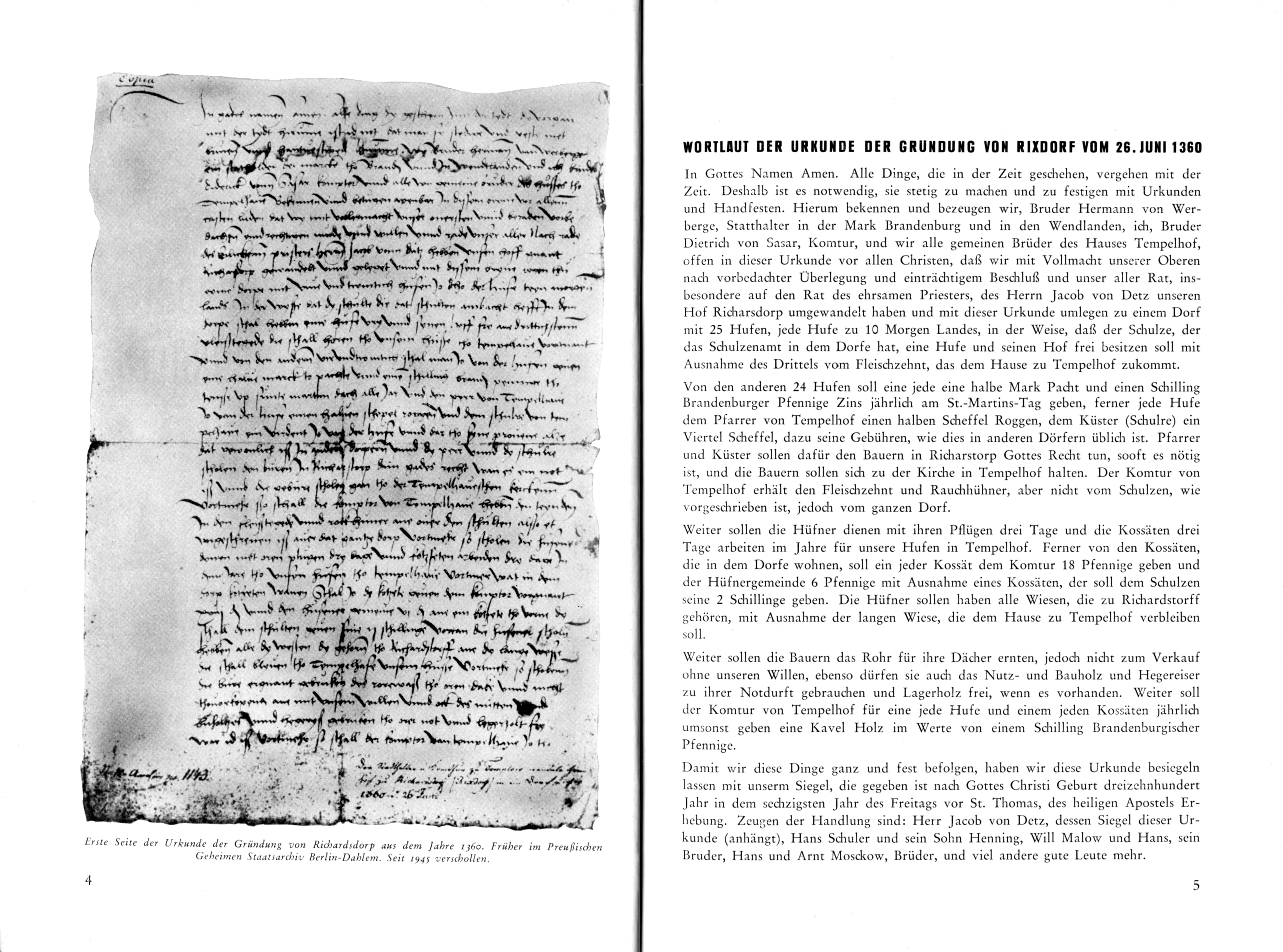
The former Rixdorf was founded around 1200 by the Knights Templar who were based in Tempelhof . Archaeological traces of a Slavic pre-settlement have not yet been found. By Wüst If the village was in a farmyard transformed the Knights Templar. In 1318 the possessions of the Brandenburg Knights Templar were transferred to the Order of St. John because the Knights Templar had been dissolved in 1312. For this reason, the coat of arms of the district bears the Johanniterkreuz . According to the founding document of June 26, 1360 in Middle Low German , the former farm of Richarsdorp (Richarstorp / Richardstorff) was converted into a village with 25 Hufen . This document, which has been missing since 1945, not only contained the first documentary mention of Rixdorf, but was also the only existing village foundation document for Brandenburg. According to the content of the document, Rixdorf had to pay taxes to the pastor of Tempelhof, so it could not have had his own village church. In 1375 the village of Rixdorf was mentioned in the land book of Charles IV as Richardstorpp , again with the 25 hooves already mentioned in the founding deed, a relatively small number (the average was around 50). However, the Commander-in-Chief of Tempelhof no longer had all rights. The center was on Richardplatz . In 1435 the Johanniter sold all their villages (Tempelhof, Mariendorf, Marienfelde and Rixdorf) to the cities of Berlin and Cölln. At this point at the latest, Rixdorf had its own village church . In 1525 the village is mentioned in documents as Ricksdorf .
From Richardsdorf and its three Low German spellings Richarsdorp, Richarstorp, Richardstorff from the 14th century, Reicherstorff, Richerstorp and Rigerstorp developed in the 15th century. In the next century Reichstorff (1541), Richstorff or Rigstorff (1542) established themselves, while in the 17th and 18th centuries the names Rechsdorff, Risdorf, Riechsdorf, Riecksdorf, Ricksdorf were common. In the 19th century, Rixdorf was more and more anchored in the official city directories and established itself as a place name.
Population increases due to immigrants from the 18th century

[1] today's Richardstraße ,
[2] today's Richardplatz ,
[3] today's Karl-Marx-Straße

In 1737, Friedrich Wilhelm I permitted the settlement of Bohemian exiles in Ricksdorf, who had been driven out because of their Protestant belief. These supporters of the Moravian Brethren built their own church and settled in a separate area away from the village green , along today's Richardstrasse . The resulting Bohemian village was finally given its own administration in 1797 as Böhmisch-Rixdorf . The remaining part of the settlement was called (German) Rixdorf at that time .
With the unification of the two independent municipalities Bohemian-Rixdorf and German-Rixdorf on January 1, 1874 to unit community the place Rixdorf had 8,000 inhabitants and grew in the following year to 15,000 inhabitants.
Rixdorf obtained town charter and was given the name Neukölln
On May 1, 1899, Rixdorf, which had 80,000 inhabitants at the time and until then was the largest village in Prussia and belonged to the Teltow district, formed its own urban district and received town rights. In 1903 Rixdorf received its coat of arms with the Johanniterkreuz and the chalice (for the Bohemian religious refugees). The renaming from Rixdorf to Neukölln took place with the consent of Kaiser Wilhelm II on his 53rd birthday on January 27, 1912 and was decided by the authorities because Rixdorf had meanwhile become the epitome of frivolous entertainment for Berliners, the then - and for Part still today - popular hit songs In Rixdorf is Musike expresses this. The negative appearance for the place should be stripped off with the name. The name Neucölln is derived from the Neucölln settlements north of the old Rixdorf, which indicate the location in front of the southern gates of the old Berlin - Cölln (cf. Neu-Kölln ).
Neukölln becomes part of Greater Berlin in 1920

With the " Greater Berlin Law " (law on the formation of a new urban community in Berlin) passed by the Prussian state parliament in spring 1920 , numerous surrounding areas were combined to form Greater Berlin and the Neukölln district together with the villages of Britz and Rudow and Buckow to the 14th county . With the administrative reform in 2001, the Neukölln district became the eighth administrative district of the federal capital.
Neukölln after the end of the Second World War until the fall of the Berlin Wall


After the Second World War , Neukölln belonged to the American Sector of Berlin and was part of West Berlin until 1990 . The Berlin Wall separated it from the neighboring Treptow district , which was part of East Berlin . Just like other traditional working-class districts in Berlin such as Kreuzberg and Wedding / Gesundbrunnen , which lay along the sector border, Neukölln became increasingly unattractive for the better-off population groups after the building of the Wall in August 1961. It became the preferred place of residence for immigrants and people with a migration background, primarily because of the inexpensive rental apartments . The guest workers , mostly from Turkey , were later joined by people from Arab countries and refugees. In the 2010s, around 15 percent of the residents of the district are of Turkish and 10 percent of Arab origin.
Since 1989
After the fall of the Berlin Wall , the isolation of Neukölln ended, but in the 1990s and 2000s the district became known as a "problem area" and a social hotspot , also because the then district mayor Heinz Buschkowsky repeatedly publicized phenomena such as crime ( procurement and other drug-related crime ), behavioral problems of school dropouts , social neglect and Islamic fundamentalism themed and going on the district administration against them. At the same time, the district has been gentrified , especially in the north of Neukölln, since the 2000s .
Since the administrative reform on January 1, 2001, the Neukölln district has been Berlin's eighth district (previously the fourteenth). Neukölln, Spandau and Reinickendorf remained the only ones without being merged with another district due to their size of more than 200,000 inhabitants.
In 2018 the Berlin Senate published a general development plan for the city. This also includes project ideas for the development of an eleven hectare area on Koppelweg, north of Mohringer Allee and the Britzer Garden . The previously agricultural land should be building land rezoned be on which houses different types of houses with a total of 150 apartments, a primary school and day-care centers arise. The areas are only partially owned by the municipalities, but private owners should also be encouraged to undertake corresponding construction projects with a share of social housing.
Education
As early as the 19th century, with the rapid population growth, the need for an extensive school building program became apparent. Towards the end of the century, at the instigation of the local council, in addition to the higher educational institution, the Städtische Realschule and the Progymnasium , seven community schools each, separately for boys and girls, were established. There was also a school for the Catholic and Protestant parishes as well as a training school . Two public libraries also contributed to improving education .
Public transport in the Neukölln district
Subway lines
S-Bahn lines
- S41: S Südkreuz - S + U Gesundbrunnen - S Südkreuz ( Ringbahn , clockwise)
- S42: S Südkreuz - S + U Gesundbrunnen - S Südkreuz (Ringbahn, counterclockwise)
- S45: S + U Hermannstraße - S Airport Berlin-Schönefeld (only Monday to Friday)
- S46: S Westend - S Königs Wusterhausen
- S47: S Spindlersfeld - S Hermannstrasse
Bus routes
- M29: U Hermannplatz - Grunewald, Roseneck
- M41: Sonnenallee / Baumschulenstraße - S + U Hauptbahnhof via the Tiergarten Spreebogen tunnel
- M44: Buckow-Süd, Stuthirtenweg - S + U Hermannstraße. At night further than N8 in the direction of Wittenau
- 104: Neu-Westend , Brixplatz - Stralau, Tunnelstrasse
- 166: U Boddinstrasse - S Schöneweide
- 171: U Hermannplatz - S Airport Berlin-Schönefeld
- 194: U Hermannplatz - Marzahn , Helene-Weigel-Platz
- 246: U Friedrich-Wilhelm-Platz - S + U Hermannstrasse
- 277: S + U Hermannstraße - Marienfelde , suburban settlement
- 341: S Köllnische Heide - Nobelstraße / Bergiusstraße - S Köllnische Heide (ring line)
- 370: Neukölln, Am Oberhafen - S + U Hermannstrasse
- 377: S Plänterwald - S + U Hermannstrasse
Bicycle traffic
In Berlin-Neukölln, the district's first bicycle street was designated in 2017 on Weserstraße on the section between Kottbusser Damm and Reuterplatz . A second bicycle road followed in 2018, which leads over the Weigandufer . There are plans to convert the section from Pannierstrasse and Pflügerstrasse into a bicycle route in Weserstrasse, thereby establishing a connection with the bicycle route on the banks of the Weigand.
Streets and squares
The longest and most densely built-up streets are Karl-Marx-Straße , Hermannstraße and Sonnenallee .
Parks, cemeteries and bodies of water (selection)
- Anita Berber Park
- Bohemian church in Rixdorf
- Comenius garden
- Heidekampgraben green corridor
- Herbert Krause Park
- Cemeteries on Hermannstrasse
- Grain park
- Lessinghöhe
- Turkish cemetery Berlin with Şehitlik mosque
- Volkspark Hasenheide (south of the street Hasenheide , which belongs to Kreuzberg ) with the rubble woman monument by Katharina Szelinski-Singer
- Von-der-Schulenburg-Park with fairytale fountain
- Landwehr Canal
- Neukölln shipping canal
- Britzer connection channel
→ See also parks in Neukölln
Buildings worth seeing
- Old post
- District court Neukölln
- Bethlehem Church
- Geyer works
- John's basilica
- Magdalenenkirche
- Martin Luther Church
- New World (Event Hall)
- Philipp Melanchthon Church
- Neukölln town hall
- Smithy on Richardplatz
- Şehitlik Mosque
- Stadtbad Neukölln
- Brewhouse of the Berliner Kindl brewery (Kindl center for contemporary art)
Shopping centers
- Kindl Boulevard
- Neukölln Arcaden
- Neucölln Carree
- HermannQuartier at the S + U-Bahnhof Hermannstraße
- Neuköllner Tor at the Neukölln S + U-Bahn station
Cultural events (selection)
- 48 hours Neukölln
- Gallery in the Körnerpark
- Home port Neukölln in the Saalbau Neukölln
- Carnival of the Cultures
- Museum Neukölln
- Neukölln Opera
- Puppet Theater Museum Neukölln
- Theater-Café Anyway
- Workshop of Cultures
A remarkable network of artists has developed in Neukölln in recent years.
Neukölln in the media
music
- In Rixdorf there is music by Littke-Carlsen based on the melody by Eugen Philippi
- Neuköln by David Bowie and Brian Eno
- Neukölln Schluckspechtsymphonie in Suff Minor by Freilestirn
- Dit is Neukölln , song by Kurt Krömer and Gabi Decker based on the melody from I Got You babe ( Sonny and Cher )
Movies
- Berlin: Hasenheide , documentary, 2010, director: Nana AT Rebhan
- Berlin-Neukölln , TV film, 2002, director: Bernhard Sallmann
- Straight , feature film, 2008, directed by Nicolas Flessa
- Knallhart , feature film, 2006, director: Detlev Buck
- My 1/4 Blues , video by Malte Ludin , 38 minutes
- Moruk , short film with Oktay Özdemir and Burak Yiğit , director: Serdal Karaça
- Neukölln Unlimited , documentary, 2010, directors: Agostino Imondi, Dietmar Ratsch
- The end of patience , made for TV, 2014, director: Christian Wagner
- 4 Blocks , Series, 2017, directed by Marvin Kren
Personalities
Sons and daughters of Neukölln
- Clara Sahlberg (1890–1977), trade unionist and resistance fighter
- Fritz Bischoff (1900–1945), communist, resistance fighter against National Socialism
- Bruno Kühn (1901–1944), communist and resistance fighter against National Socialism, brother of Lotte Ulbricht
- Lotte Ulbricht (1903–2002), SED functionary, wife of Walter Ulbricht
- Heinz Riefenstahl (1906–1944), engineer
- Ernst Wilhelm Borchert (1907–1990), actor, radio play and voice actor
- Wilhelm Haegert (1907–1994), Ministerialrat and Head of the Propaganda Department in the Reich Ministry for Public Enlightenment and Propaganda and SA-Sturmbannführer
- Inge Meysel (1910–2004), actress
- Klaus Gysi (1912–1999), GDR politician and diplomat; Ambassador to Italy, the Vatican and Malta (1973–1978)
- Alexander Voelker (1913–2001), politician, honored in 1980 as city elder of Berlin
- Friedel Hoffmann (1912–1997), resistance fighter against National Socialism and SED functionary
- Erika Bergmann (1915–1996), guard in the Ravensbrück concentration camp
- Wolfgang Kieling (1924–1985), actor and voice actor
- Horst Bosetzky (1938–2018; pseudonym: -ky ), sociologist and writer
- Gringo , rapper and actor
- Ali Bumaye (born 1985), rapper
Well-known residents of Neukölln
- Güner Yasemin Balcı (* 1975), writer
- Bruno Bauer (1809–1882), theologian and philosopher
- Martin Betz (* 1964), cabaret artist
- Frank Bielka (* 1947), politician (SPD), district mayor of Neukölln
- Sebastian Blomberg (* 1972), actor
- Hermann Boddin (1844–1907), Mayor of Rixdorf
- Kurt Exner (1901–1996), politician (SPD)
- Ernst Moritz Geyger (1861–1941), sculptor and painter, lived at Karl-Marx-Platz 16-18
- Traugott Giesen (* 1940), Evangelical Lutheran clergyman and Christian author, worked for ten years as a pastor in Neukölln
- Ursula Goetze (1916–1943), resistance fighter
- Curt Kaiser (1865–1940), the last Lord Mayor of Rixdorf, lived at Kaiser Friedrichstrasse 64 (today: Sonnenallee 124)
- Heinz Kapelle (1913–1941), politician (KPD) and resistance fighter, lived at Weserstraße 168
- Fritz Karsen (1885–1951), reform pedagogue, lived at Sonnenallee 79
- Reinhold Kiehl (1874–1913), Rixdorf town planner
- Paul Alfred Kleinert (* 1960), writer, translator and editor
- Stephan Krawczyk (* 1955), songwriter and writer
- Kurt Krömer (* 1974), presenter, actor and entertainer
- Franz Künstler (1888–1942), politician (SPD, USPD) and resistance fighter, lived at Elsenstrasse 52
- Gustav Leyke (1851–1910), local politician
- Felix Lobrecht (* 1988), comedian
- Kurt Löwenstein (1885–1939), SPD politician, member of the Reichstag and city councilor in Berlin-Neukölln, school reformer, lived at Geygerstraße 3 (memorial plaque)
- Alice Phoebe Lou (* 1993), singer-songwriter
- Will Meisel (1897–1967), composer and publisher, lived at Jonasstrasse 22
- Tobias O. Meißner (* 1967), writer
- Ilse Meudtner (1912–1990), athlete and dancer
- Erich Raddatz (1886–1964), politician (SPD)
- Ulrich Roski (1944–2003), songwriter, lived on Kirchhofstrasse
- Graziella Schazad (* 1983), singer-songwriter
- Werner Seelenbinder (1904–1944), wrestler and resistance fighter, trained in Neukölln and is buried there
- Katharina Szelinski-Singer (1918–2010), sculptor
- Anja Tuckermann (* 1961), author and journalist
- Grete Walter (1913–1935), resistance fighter, lived at Fuldastraße 12
- Daniel Friedrich Wanzlick (1819–1877), village head of Böhmisch-Rixdorf
- Joachim Weckmann (* 1953), entrepreneur
- Hermann Weigand (1854–1926), Rixdorf town planner
- Martin Weise (1903–1943), politician (KPD) and resistance fighter, lived at Jonasstrasse 42
- Michael Wendt (1955–2011), politician (Alliance 90 / The Greens)
- Lisbeth Wirtson (1887–1977), actress and teacher, worked from 1933 to 1937 as a teacher in Berlin-Neukölln
- Emil Wutzky (1871–1963), trade unionist and local politician (SPD)
- Engelbert Zaschka (1895–1955), inventor and helicopter pioneer


See also
literature
- Dieter Althans, Robert Dupuis, Cornelia Hugt, Rainer Pomp, Jan Sonnenberg: Rathaus Rixdorf - Rathaus Neukölln, publication on the occasion of the 100th anniversary of the Neukölln town hall. District Office Neukölln of Berlin, District Mayor / Building Department, Berlin 2008, ISBN 978-3-00-026396-5 .
- Heinz Buschkowsky : Neukölln is everywhere . Ullstein Buchverlage, Berlin 2012, ISBN 978-3-550-08011-1 .
- District Office Neukölln of Berlin, Dept. Construction (Ed.): 100 Years of Building for Neukölln - A Municipal Building History. Berlin 2005, ISBN 3-00-015848-0 .
- Christiane Borgelt, Regina Jost: Architecture Guide Berlin-Neukölln. Stadtwandel Verlag, Berlin 2003, ISBN 3-933743-91-5 .
- Wolfgang Borowski, District Office Neukölln of Berlin (Ed.): Berlin-Neukölln - Its history and monuments Rixdorf. Berlin 1999.
- Verena S. Diehl, Jörg Sundermeier, Werner Labisch (eds.): Neuköllnbuch. Verbrecher-Verlag, Berlin 2003, ISBN 3-935843-28-3 .
- Bernd Kessinger: Neukölln. The history of a Berlin borough. Past Publishing, Berlin 2012, ISBN 978-3-86408-064-7 .
- Neuköllner Kulturverein (Ed.): Close-up of Neukölln. Cinemas, cameras, copier. Argon Verlag, Berlin 1989, ISBN 3-87024-153-5 .
- Falk-Rüdiger Wünsch: Neukölln - tell old pictures. Sutton Verlag, Erfurt 1998, ISBN 3-89702-096-3 .
- Dorothea Kolland (Ed.): "We were ten brothers ..." Traces of Jewish life in Neukölln . Hentrich & Hentrich Verlag, Berlin 2012, ISBN 978-3-942271-29-5 .
Web links
- The Neukölln district on the official Berlin website
- Berlin-Neukölln: its history and monuments - Rixdorf (private website)
- Neukölln with a difference . polar online, edition: September 2007
- Picture gallery of Neukölln places / squares
Individual evidence
- ↑ Say finally Kreuzkölln! , Tagesspiegel April 12, 2016, accessed June 20, 2018
- ^ Wording of the founding deed of Rixdorf from June 26, 1360 : Karl Ernst Rimbach: 600 years from Richardsdorf to Neukölln. Published by the Neukölln District Office of Berlin, Heimat und Werk Verlag, Berlin 1960.
- ↑ Herbert Schwenk: All things ... proceed with the tydt. Rixdorf becomes Neukölln - all sorts of spellings . In: Berlin monthly magazine ( Luisenstädtischer Bildungsverein ) . Issue 4, 2001, ISSN 0944-5560 , p. 43-50 ( luise-berlin.de ).
- ↑ berlin.de Chronicle and history of Neukölln at berlin.de, accessed on January 12, 2020
- ↑ How Rixdorf became Neukölln. In: Berliner Morgenpost , October 7, 2008.
- ^ Law on the formation of a new city council in Berlin
- ↑ Ulrich Paul: On field and corridor. Where Berlin is growing: The Senate is planning eleven new residential areas. The Berliners should have a say. In: Berliner Zeitung , May 29, 2018, p. 14.
- ^ Authorities, institutions, associations . In: Address book for Berlin and its suburbs , 1900, V, Rixdorf, p. 158.
- ↑ Weserstraße is now Fahrradstraße. In: Berliner Abendblatt . September 27, 2017, accessed on March 17, 2019 (German).
- ^ Website of the Huxley . Archived from the original on December 9, 2010. Retrieved on December 15, 2010.
- ^ Gallery in the Körnerpark - exhibitions . Retrieved December 26, 2018.
- ^ Website of the home port of Neukölln . Retrieved December 15, 2010.
- ^ Website of the Carnival of Cultures . Retrieved December 15, 2010.
- ^ Museum Neukölln . Retrieved December 26, 2018.
- ^ Website of the Neukölln Opera . Retrieved December 15, 2010.
- ^ Website of the Puppet Theater Museum Neukölln . Retrieved December 15, 2010.
- ↑ Cabaret in the Schillerkiez - the theater café "Sowieso" .
- ^ Website of the Workshop of Cultures . Retrieved December 15, 2010.
- ↑ There is music in Rixdorf . District Office Neukölln, accessed on September 23, 2009.
- ↑ Neukölln Schluckspechtsymphonie in Suffmoll from Freilestirn Kreativkiez Neukölln, accessed on November 28, 2011.
- ↑ Berlin: Hasenheide hasenheidefilm.de, accessed on 28 November of 2010.
- ↑ Berlin-Neukölln in the Internet Movie Database (English)
- ↑ Kreuzkölln - Kiez in a double feature . Retrieved October 17, 2009.
- ↑ Info about the film. Retrieved March 11, 2010.
