Anita Berber Park
| Anita Berber Park | |
|---|---|
| Park in Berlin | |

|
|
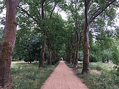
| Plane avenue in the Anita Berber Park | |
| Basic data | |
| place | Berlin |
| District | Neukölln |
| Created | 2015 to 2017 |
| Surrounding streets |
Leinestrasse , Hermannstrasse , Warthestrasse |
| Buildings | Playgrounds, runway lighting |
| use | |
| User groups | Foot traffic ; leisure |
| Technical specifications | |
| Parking area | 6.5 ha |
The Anita-Berber-Park is located in the Berlin district of Neukölln, west of Hermannstrasse, in the former approach path of Tempelhof Airport . It was named in 2017 after the German dancer, actress and self-performer Anita Berber .
history
In the middle of the 19th century there were bottlenecks for funerals in the fast-growing Luisenstadt . The cemeteries were filled quickly. In 1865, therefore, the parishes of St. Thomas , St. Jacobi and St. Michael purchased arable land in front of the gates of Berlin in order to create further cemeteries there. Nevertheless, as early as 1872, the St. Thomas cemetery to the east of Hermannstrasse was also almost completely occupied. The parish therefore decided to create another cemetery west of the street, the New St. Thomas Cemetery. In 1928 the namesake Anita Berber was buried there. Tempelhof Airport was built in the immediate vicinity of the site at the beginning of the 20th century.
After the end of the Second World War , the residents largely cut down the trees in the cemetery in order to set up a temporary runway lighting system on the cemetery grounds in 1948 . However, the central line of sight of the two cemeteries, the avenue lined with plane trees , was retained, as was the enclosure built in 1898 consisting of a wall on Hermannstrasse. According to tradition, the cemetery looked like a "fairground" during the Berlin Airlift . In the expectation that raisin bombers would drop aids on the approach to Tempelhof, people are said to have "raved" over the graves. In 1961/1962 the steel signal masts were replaced by new concrete masts. They were in operation until the airport was closed in 2008 and, together with the enclosure wall, are a listed building . From the end of the 1980s, no more burials were carried out in the cemetery. After the waiting periods had expired, funeral directors gradually leveled the graves; The cemetery closed in 2012.
In 2015, the Neukölln district initiated a public participation process with the aim of carefully developing the green space. For financing, the district resorted to funds that had been made available for compensatory measures for the 16th construction phase of the A 100 . The costs amounted to around two million euros, including 354,000 euros for the landscape architect. 66,000 euros were available for the furniture. The newly designed park was opened to the public on July 10, 2017.
Design
In addition to the park design, it was a declared aim of the Senate Administration to “preserve and promote special habitats and habitat structures for plants and animals”. The old trees with caves and deadwood were largely retained. Due to the earlier use as a cemetery, the landscape architects found a great variety of trees . There were also numerous lawns and meadows. These have been revitalized through partial reseeding and targeted mowing . Craftsmen set up numerous seating areas; a dog run area was created. In addition to the existing entrance on Hermannstrasse, the landscape architects built a total of three new entrances to the park using two stairs and a ramp on Leinestrasse.
In 2017, 20 different breeding bird species were detected in the park , including the nightingale .
Web links
- Anita-Berber-Park , website of the landscape architects Henningsen, accessed on June 24, 2018.
- Anita-Berber-Park formerly St.Thomas Friedhof , website of the district management Schillerpromenade with documentation of the participation process, accessed on June 24, 2018.
Individual evidence
- ↑ Information board on the park at the Hermannstrasse entrance, June 2018.
- ^ Henningsen landscape architects: Anita-Berber-Park , flyer, no date, p. 4.
- ^ Philipp Siebert: The Anita Berber Park and its dazzling namesake . In: Berliner Morgenpost , July 10, 2017, accessed on June 24, 2018.
- ↑ Information board on the park at the Hermannstrasse entrance, June 2018
Coordinates: 52 ° 28 ′ 20.6 " N , 13 ° 25 ′ 37" E
