Hermannplatz
| Hermannplatz | |
|---|---|
| Place in Berlin | |
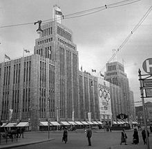
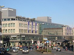 Karstadt department store on Hermannplatz. View from Hermannstrasse |
|
| Basic data | |
| place | Berlin |
| District | Neukölln |
| Created | 1885 |
| Newly designed | 1985 |
| Confluent streets |
Hermannstrasse , Hasenheide , Urbanstrasse , Kottbusser Damm , Sonnenallee , Karl-Marx-Strasse |
| Buildings |
Karstadt am Hermannplatz , Hermannplatz underground station |
| use | |
| User groups | Pedestrians , cyclists , road traffic , buses |
| Technical specifications | |
| Square area | 160 m × 50 m |
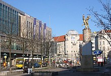
The Hermann Square is a town square in the north of Berlin district of Neukölln . He has this name since 9 September 1885. Similar to the beginning here Hermannstraße the name refers to Hermann the Cherusci , but the idea came up early on that the Rixdorfer community leader Hermann Boddin is meant. The square belongs to Neukölln, only the side with the Karstadt department store (house numbers 5–10) belongs to the Friedrichshain-Kreuzberg district . Located at the extreme south-east corner of the inner-city district of Kreuzberg , the square was and is considered the gateway to Neukölln .
History and creation
In contrast to many other urban squares, Hermannplatz is neither the nucleus nor the center of a settlement area. Rather, it is a stretch of road that developed into a square between two bends in the road (later intersections). Originally, Hermannplatz was only part of the way from Berlin via Rixdorf to Mittenwalde . The crossing path has led since ancient times at the foot of the Teltow plateau along the southern edge of the marshy Spree valley .
Turtleneck

As early as August 1543, when Richardsdorf (later: Rixdorf ) became the property of the city of Cölln , there was an inn on the south side of what would later become Hermannplatz . Among other things, horses were changed here. Around 1737 the Rollkrug inn was built on this site . The name was derived from the rolling mountains beginning to the south, an ice age mountain range. In the middle of the 18th century the square was also named Platz am Rollkrug . For a long time the turtleneck stood alone in the square. It was not until the early days of the company that a metropolitan atmosphere developed within a few decades and the rollkrug almost seemed like a foreign body.
Towards the end of the 19th century, the Berlin suburb of Rixdorf was considered an entertainment district and the restaurant also enjoyed a dubious reputation. In 1885 the square at the Rollkrug was renamed Hermannplatz, in 1907 the Rollkrug was torn down and made room for a commercial building. The office building was also known as the “ Neuer Rollkrug ” and still bears the inscription “Rollkrug” above the portal in Hermannstrasse. The building has been a listed building since 1988.
Further development
In the location plan from 1846, there is another inn on Hermannplatz next to the Rollkrug . The Gasthaus Zur guten Hoffnung is located roughly at the later corner of Hermannplatz and Sonnenallee . The development plan for the surroundings of Berlin from 1862 still contains a building at this point, but no longer an inn. There is an Gasthof zum Spreewald on the opposite side of the street (corner Hermannplatz / Urbanstraße) . There is also a pharmacy on the corner of Hermannplatz and Hasenheide .
Opposite the Rollkrug there was an Accisehaus , in which until 1874 customs had to be paid for goods imported into Berlin. It could still be found there at the beginning of the 20th century, but had to give way to the widened street layout of Hermannstraße when the Hermannplatz was redesigned and the new subway was built.
The front building at Hermannstrasse 4 was demolished to supply power to the underground and a substation was built there as a temporary solution. 1927/1928 was then in the Hermannstraße 5-8, designed by Alfred Grenander the Power Works built Hermann Street, which houses the new road layout and since the end of the 20th century monument is. The AC voltage supplied by the Kottbusser Ufer substation with 6000 volts and 50 Hertz was converted there into DC voltage with 780 volts. The change in the street layout at the corner building facing Hasenheide and the adjacent plot of land at Hermannstraße 4 is still clearly legible, as Hermannstraße can be seen directly into the backyard of the building or onto the fire wall of the corner building.
At the end of the 19th century (around 1860) the square was built on with tenement houses on both sides. At that time, Hermannplatz had less of the effect of a square than that of a wide, short street. As early as the mid-1920s, the residential buildings on the west side of the square were demolished to make way for the subway and a department store . When the west side of the square was rebuilt, it was also widened by 20 meters and received its current dimensions.
Second World War
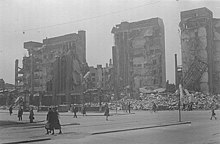
After the massive building of the department store on Hermannplatz was spared from aerial bombs to the end, it fell victim to street fighting at the end of April 1945.
Battle for Berlin
On April 16, 1945, the Red Army began attacking the Oder. The 1st Belarusian Front of Soviet Marshal Zhukov aimed from Küstrin to the eastern districts of the city . The date is considered to be the beginning of the battle for Berlin .
Shelling of Hermannplatz
April 21, 1945: Hermannplatz was one of the first places in Berlin to be affected by the Soviet attack. The artillery, whose shells suddenly struck the square, belonged to the 1st Guards Panzer Army, whose units penetrated the city from the southeast in the direction of Neukölln.
One historian describes the situation:
“The sound was different from anything the Berliners had heard before - different from the whistling of bombs falling or the barking of the flak. The people standing in front of the Karstadt department store on Hermannplatz raised their heads in amazement and listened. It was a low howl, somewhere in the distance, but then it turned into a hideous, high-pitched screech. For a moment, people seemed hypnotized. Then they broke apart. But it was too late. Artillery shells struck all over the square, the first to reach the city. Torn corpses slammed against the boarded shop windows. Men and women lay in the street screaming and writhing in pain. It was Saturday, April 21st, exactly 11:30 am. Berlin was a front-line city. "
The cannonade affected the entire inner city area. The Soviet troops were still standing in the run-up to Köpenick, Karlshorst and Buckow and only approached slowly - however, the fire was supposed to disrupt the provision of the defense and began to drive the population towards the city center.
On the morning of April 25th “units of the 4th Guard Corps infiltrated Neukölln; these forces were supported by the 11th Guards Panzer Corps ”. The advance of the Soviet tanks could be followed within sight. The defense at Hermannplatz was organized by SS-Brigadführer Krukenberg .
Karstadt on Hermannplatz
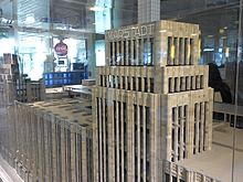
The building for the Karstadt group was designed by its in-house architect Philipp Schaefer and built between 1927 and 1929. The body of the building towered over Hermannplatz by 32 meters. Two identical towers rose a further 24 meters above the building ensemble. These in turn were each crowned by a 15 meter high column of light. With its shell limestone facade and its vertical structure, the building was reminiscent of the high-rise architecture in New York at the time . The vertical structure became particularly clear in the dark through the light strips on the building and the light columns on the towers.
At the time, the building was considered the most modern department store in Europe. Karstadt had 72,000 m² of usable space on nine floors (two of which were underground), and 24 escalators connected the floors. There were also 24 passenger, 13 dining and eight freight elevators, one of which could transport a fully loaded truck to the fifth floor of the food department. The Karstadt department store was the first in Europe to have underground access from the underground station; From the U7 and U8 lines, visitors can get to the building's basement without having to go through the surface.
“The building with the two blue light towers, which rose up on the huge roof garden as an aviator signal for the nearby Tempelhof, gave the cityscape a new stimulus for the senses. To show how comfortable his staircases were, Karstadt had the school rider Cilly Feindt ride her white horse from the ground floor to the roof garden. "
Karstadt on Hermannplatz quickly developed into a well-known city attraction. In addition to the wide range of goods, the audience was particularly enthusiastic about the 4000 m² roof garden, which could accommodate 500 people. The music bands playing every afternoon and the view from 32 meters over Kreuzberg and Neukölln made for the unique ambience.
Destruction of the Karstadt building at the end of the Second World War
Order gradually collapsed in the city and an eyewitness “heard from someone that the huge Karstadt department store was being looted. She ran there immediately. [...] People took what they could get. […] In the afternoon the huge department store blew up. The SS blew it up so as not to let the supplies, worth 29 million marks, which they had stored in the cellars fall into the hands of the Russians. There were several deaths. "
In the evening of April 25, the doctor from a nearby hospital for French prisoners of war observed the scene: "On the right, a cloud of smoke hid the two 80-meter-high towers of the Karstadt department store, which towered over the district."
The defense around Hermannplatz lasted until the next morning.
On that day, April 26th, the observer wrote: "The towers of the Karstadt store had disappeared and the big building was on fire."
Krukenberg "thought his men were too good to be 'burned' at a comparatively unimportant section, and so he managed to get his troops moved from Neukölln to the city center."
reconstruction
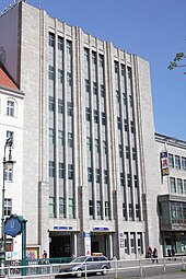
A small part of the department store building on Hasenheide Street was preserved. Sales started again at the end of July 1945. Reconstruction began in 1950. The architect Alfred Busse designed a four-storey building that was connected to the remaining part of the building and was built on the corner of Hasenheide and Hermannplatz by 1951.
Starting from this building, the building was enlarged continuously in the following decades. The last enlargement so far took place in 2000 and went hand in hand with an extensive revision of the entire appearance. The architects commissioned with the extensions were Helmut Kriegbaum, Jürgen Sawade and Udo Landgraf.
Reconstruction planning by Signa Holding
In January 2019, Signa Holding , the owner of the Karstadt department store on Hermannplatz, announced that it was building an interpreted reconstruction of the facades destroyed in World War II, including the striking towers. The additional floor area should u. a. be used for restaurants, offices, apartments and retail.
post war period
Except for the building at the intersection with Sonnenallee , the residential buildings on the east side of the square survived the Second World War. After the war, a single-storey low-rise building was erected on Sonnenallee, which was expanded in the late 1990s. A building was created that was adapted to the eaves height of the neighboring buildings and into which a hotel moved.
The redesign of the traffic facilities ( tram stops and lanes were rearranged) with the construction of the underground and the widening of the square in 1929 lasted until the mid-1980s. After the tram was shut down in West Berlin in the mid-1960s , the tracks lay useless on the square for years. In the early 1980s, the track systems were removed when the square was redesigned again. On April 27, 1985, the redesigned square was inaugurated with a folk festival .
Since then, it has offered a large pedestrian and market area, on the center of which is the bronze plastic dancing couple by Joachim Schmettau . The couple, also popularly known as the “Rixdorfer Tanzpärchen”, used to turn twice an hour on their own axis, but have stood still since the beginning of the 21st century. The sculptor Joachim Schmettau, founding member of the group Aspects of Berlin's Critical Realists, made the bronze sculpture for the opening of the Federal Garden Show in the Britz Garden .
Future design
In 2009 the Neukölln District Office commissioned a feasibility study for the redesign of Hermannplatz. The plan provides for the two lanes to be merged on the north-west side so that a large square is created in front of the houses on the south-east side. This is to be designed as a pedestrian zone in which BVG buses only pass through at night and have their stop, while cafes and pubs set up tables and chairs during the day. This is intended to improve the quality of stay, reduce the risk of accidents and make the square more family-friendly. In future, bicycle traffic is to be guided to cycle lanes on the road instead of the sidewalk cycle paths. Construction is scheduled to start in 2015 at the earliest. According to information from the Senate from September 2015, the indicated renovation work should begin in autumn 2014 after the completion of the corresponding work in the adjacent areas. The necessary funds come from the urban redevelopment funding program. In October 2014, the district offices involved said that the "start of construction for the redesign will be in 2016". In response to a specific request, however, the Senate announced that the “period (is) not known”.
The space as a limit
Hermannplatz was always a border. If the border between Berlin and Rixdorf used to run across the square, it was later the border between the districts of Kreuzberg and Neukölln . With the widening of the square, the border was moved from the center of the square to the western edge of the site. Since the Karstadt building, erected after the Second World War, protrudes over the sidewalk on the first floor, this leads to the curious situation that the department store , which is completely located in Kreuzberg, protrudes into the Neukölln airspace and Karstadt pays a fee for this to the Neukölln district for " Special use of public roads ”(end of the 1990s: 15,000 marks ).
Adjacent streets
Hermannplatz is currently represented as a broad span between two intersections. Urbanstrasse , Kottbusser Damm and Sonnenallee meet at the northern intersection . Urbanstraße was laid out in 1874 and meets the square from the west. The Kottbusser Damm was called Rixdorfer Damm until 1874. This street name dates back to the 16th century and the street is one of the oldest in the Kreuzberg district. The oldest records of today's Sonnenallee date from 1890. The name Kaiser-Friedrich-Straße has been known for the street since 1893. In 1938 the street east of Hermannplatz with Braunauer Strasse (named after Hitler's birthplace ) was given a National Socialist name. In 1947 it disappeared from the streets and the street was named Sonnenallee.
The intersection on the south side of Hermannplatz is the meeting point of the streets Hasenheide , Hermannstraße and Karl-Marx-Straße. The street Hasenheide was laid out as a path as early as 1678 and expanded as a fortified road in 1854 . The Hermannstraße as a connection to Britz also has a very long history and was only called Straße nach Britz until the end of the 19th century . In 1712, the post road Berlin - Mittenwalde - Dresden was opened leading over the current route of Hermannstrasse . Karl-Marx-Straße (until July 31, 1947 Berliner Straße ) is (like Kottbusser Damm) one of the oldest streets on the square. Even before Poststrasse to Dresden was opened via Hermannstrasse, a post route led to Cottbus via Berliner Strasse .
A traffic census from 1882 documents the increasing importance of Hermannplatz. 750 carts and 8,000 people (not including the carters) were counted in one day. A good hundred years later, on September 11, 1986, a survey alone at the southern intersection (Karl-Marx-Strasse / Hermannstrasse / Hasenheide) revealed 1,580 cyclists in twelve hours.
Public transport
Omnibus and tram
On June 6, 1885, a horse-drawn tram line from Rollkrug to the corner of Hermann Knesebeckstrasse (later Silbersteinstrasse) was opened. The operator of the horse-drawn railway, which a good two years later (on January 1, 1888) became part of the Große Berliner Pferde-Eisenbahn AG , was the municipality of Rixdorf. The Südliche Berliner Vorortbahn Aktiengesellschaft started operating the first electric tram across Hermannplatz on July 1, 1899 . The line was a ring line and led via Rixdorf, Britz, Tempelhof , Schöneberg and Kreuzberg. Because the ring led through uninhabited area in the southern area, the vernacular gave it the name "Desert Railway".
In 1905, a suspension railway was planned that would run from Gesundbrunnen station via Hermannplatz to Rixdorf station (Südring) , later: Neukölln (Südring). However, the planning was not implemented.
In the 1920s, numerous bus routes went into operation and Hermannplatz developed into a bus hub. Several lines ran long distances across the city. For example, on December 12, 1921, line A 29 from Pankow , Breite Straße to Hermannplatz, was 14.4 kilometers long.
In the area above the underground tunnels, all the streets leading to Hermannplatz had tram tracks until 1930 and the trains of 15 lines stopped at the square. Since the 1950s, however, there has been a gradual changeover of operations to the omnibus in West Berlin . On October 1, 1964, the last line (line 27) that ran across Hermannplatz was discontinued. On the Urbanstraße - Sonnenallee axis, line 95 touched Hermannplatz until May 2, 1965. Until the Britz depot was closed in 1966, there were still service trips on some sections. Since German reunification , efforts have been made to extend the tram from the eastern part of Berlin (e.g. Warschauer Strasse ) to Hermannplatz, although this is not expected in the next few years (as of 2016).
Time of the subway
→ Main article: Hermannplatz underground station
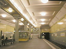
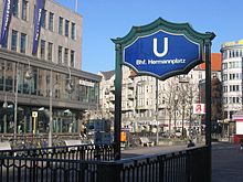
The greatest change in local public transport brought Hermannplatz in the 1920s. The subway went into operation on April 11, 1926 . The first section Hasenheide - Bergstrasse (later: Südstern - Karl-Marx-Strasse ) of the north-south railway could be opened. It led from Seestraße in Wedding to Bergstraße in Neukölln. The second platform on Hermannplatz experienced its first day of operation on July 17, 1927. This was also the birthday of the GN-Bahn ('GN' stands for Gesundbrunnen – Neukölln), which was later referred to as the U8 line, when the relatively short section from Boddinstraße to Schönleinstraße (a good 1.5 km) went into operation . The Hermannplatz underground station was designed as a tower station , with the U8 platform located directly below the street and the north-south platform crossing it at a depth of nine meters. The platform of the later line U7 has been laid out as a large hall through which the U8 platform slides as a crossbar. The ceiling of both platforms is therefore at the same height. The intersection of the two lines is below the intersection of the streets Hasenheide - Karl-Marx-Straße (U7) and Hermannplatz - Hermannstraße (U8). When the station opened, the escalators between the two platforms were another special feature: They were the first in the entire area of the Berlin subway. The architects of the station were Alfred Grenander and Alfred Fehse.
See also
literature
- Cornelia Huge: The Karl-Marx-Strasse. Facets of a living and working space . Kramer, Berlin 2001, ISBN 3-87956-271-7 .
- Lothar Uebel: Karstadt on Hermannplatz. A good piece of Berlin . Ed .: Karstadt Warenhaus AG. 2000.
Web links
- Hermannplatz. In: Street name lexicon of the Luisenstädtischer Bildungsverein (near Kaupert )
- Axel Mauruszat: berlin-hermannplatz.de with more information on Hermannplatz
Individual evidence
- ↑ Tony Le Tissier: The fight for Berlin 1945 . Ullstein Verlag, Frankfurt / Main / Berlin 1991, p. 87 f. ISBN 3-550-07801-3 .
- ↑ The processes are described in detail in: Erich Kuby: Die Russen in Berlin 1945 . Scherz Verlag, Munich 1965, p. 146 ff.
- ↑ Last hand at the department store . In: Berliner Tageblatt and Handelszeitung , April 21, 1929.
- ↑ Cornelius Ryan: The last fight . P. 282 f.
- ↑ Tony Le Tissier: The fight for Berlin 1945 . P. 138 and 147. Correction to the height information: The towers of the house were 56 meters long, with the 15 meter high light columns a total of 71 meters.
- ↑ Krukenberg, more of an "old style" troop leader, was not responsible for the destruction of the Karstadt house.
- ↑ Erich Kuby: The Russians in Berlin 1945 , p. 148. Krukenberg later wrote his memoirs under the title Kampftage in Berlin .
- ↑ SIGNA: Berlin Hermannplatz , accessed on January 23, 2018
- ↑ Office of the City and Transport Research and Planning Group - with a simulation image (around the middle of the page)
- ↑ Hermannplatz is to be moved . In: Der Tagesspiegel , June 3, 2012.
- ↑ Inquiry from the Greens ( Memento of the original from May 18, 2015 in the Internet Archive ) Info: The archive link was automatically inserted and not yet checked. Please check the original and archive link according to the instructions and then remove this notice. - BVV Kreuzberg-Friedrichshain, October 2013
- ↑ Conversion of the southern Karl-Marx-Straße on stadtentwicklung.de, accessed on November 1, 2015.
- ↑ Jörn Hasselmann: Conversion plans are not implemented. In: Der Tagesspiegel , October 14, 2014.
Coordinates: 52 ° 29 ′ 14 ″ N , 13 ° 25 ′ 29 ″ E


