
Berlin-Reinickendorf
|
Reinickendorf district of Berlin |
|
|---|---|
  |
|
| Coordinates | 52 ° 34 ′ 0 ″ N , 13 ° 20 ′ 0 ″ E |
| surface | 10.5 km² |
| Residents | 83,909 (Dec. 31, 2019) |
| Population density | 7991 inhabitants / km² |
| Incorporation | Oct. 1, 1920 |
| Postcodes | 13403, 13407, 13409 |
| District number | 1201 |
| Administrative district | Reinickendorf |
Reinickendorf is a district in the Reinickendorf district of Berlin of the same name , which emerged from the Angerdorf Alt-Reinickendorf .
Location and urban development

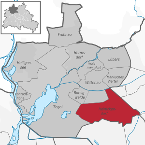
The district already has a lower suburban construction method than the neighboring district of Wedding with its tenement quarters in the city center district of Mitte . In the east, the district of Pankow joins with the districts of Niederschönhausen and Wilhelmsruh , the border is formed by the northern railway . Adjacent districts within the Reinickendorf district are Wittenau in the north with the Nordgraben on a section of the district boundary and the workers' housing estate Borsigwalde and Tegel in the west.
The district is located in the approach lane of the Tegel Airport to the west . The exposure of residents to aircraft noise is particularly high in the Reinickendorf district. As a result, some of the residential buildings received soundproof windows in the 1960s and 1970s. Due to the requirements for structural noise protection , only a few residential buildings have been built in Reinickendorf since the 2000s. Tegel Airport is to be closed after the completion of Berlin Brandenburg Airport .
history

From the foundation to the 18th century
Reinickendorf was founded around 1230 as an anger village , which probably owes its name to a locator named Reinhard. It was first mentioned in documents as Renekendorf in 1344. In Charles IV's land register (1375), Reynekenstorf was mentioned in the place register, but without detailed information on the village, a rare exception. More details followed only in 1397: The village had 40 hooves , four of which were parish hooves and six were Schulzen hooves . There was a jug and 13 kossettes . Ten of the 30 farmer's hooves subject to interest were converted shortly afterwards into free hooves on an estate . Already before 1391 the village belonged to the city council of Berlin until 1632. At first the village was sold to Peter Engel, but his son Christian Engel got into financial difficulties in 1653, so that he leased his feudal right for 50 years . In 1680 he left the right of repurchase to the council, which had to negotiate the purchase for seven years before Reinickendorf was returned to the city of Berlin on April 1, 1710. Until 1872 it belonged again to the council. Because of the Pfarrhufen mentioned in 1397, Reinickendorf was considered a church village, so by then at the latest it will have owned a church on the village green, probably made of wood or half-timbered .
19th century to the end of World War II

In the middle of the 19th century, Reinickendorf was also affected by industrialization and experienced a significant boom with the completion of the Northern Railway in 1877. The Kremmener Bahn followed in 1893 and the Heidekrautbahn in 1901 , making Reinickendorf a well-developed Berlin suburb.
The Blessing Church on Auguste-Viktoria-Allee was consecrated in 1892 .
At the end of the 1920s, the Paddenpuhl housing estate and the White City on Aroser Allee were built according to plans by the architect Otto Rudolf Salvisberg , which was added to the UNESCO World Heritage List in July 2008 as one of six modernist housing developments in Berlin .
Reinickendorf was incorporated into Greater Berlin in 1920 and gave its name to the district of the same name , to which (since the last administrative reform in 2001) the districts of Wittenau , Tegel , Heiligensee , Frohnau , Hermsdorf , Lübars , Waidmannslust , Konradshöhe , Märkisches Viertel and since 2012 belong to Borsigwalde .
Initially, the (meanwhile) Pankow locations Wilhelmsruh and Schönholz were also parts of Reinickendorf; However, they were added to the Pankow district in 1938 as a result of an area swap.
Post-war period until reunification
This administrative act was not reversed by the Allies after the Second World War , so that when the city was later divided, the northern railway line formed the border for the areas south of the northern trench : the Wilhelmsruh and Schönholz stations - despite their one- sided accessibility from the west during the time of the Wall - retained the Names of the Pankow localities east of the route.
The Albert Schweitzer Church was built in 1969 . In the 1960s, horticultural and poultry farms were established between the village of Lübars and the Märkisches Viertel .
Reinickendorf was part of the French sector of Berlin between 1945 and German reunification in 1990 .
Since 1990
After the fall of the Berlin Wall , the occupying powers withdrew from all over Berlin. The border to the eastern neighboring district of Pankow could be crossed again unhindered. Commercial areas in particular developed on former military sites. Horticulture and poultry farms use an area of around ten hectares , but have been partially abandoned since the end of the 20th century because there is more development potential in the Berlin area. An urban development plan published by the Berlin Senate in 2018 now provides that "small-scale residential use" is to be made possible here; 250 to 500 new apartments are planned by 2025.
traffic
In the local public transport, the district is accessible through the S-Bahn stations Schönholz and Wilhelmsruh on the Nordbahn (lines S1 and S85 ) as well as Alt-Reinickendorf , Karl-Bonhoeffer-Nervenklinik and Eichborndamm on the Kremmener Bahn (line S25 ). The underground line 6 with the stations Kurt-Schumacher-Platz , Scharnweberstraße and Otisstraße as well as the underground line 8 with the stations Franz-Neumann-Platz , Residenzstraße , Paracelsus-Bad and Lindauer Allee also run through the Reinickendorf district . Furthermore, several bus routes open up the district.
The federal road 96 and the A 111 as European road 26 lead through the district. The connection is via the Eichborndamm , Kurt-Schumacher-Platz and Seidelstrasse junctions .
Ditches and ponds
See also
- List of streets and squares in Berlin-Reinickendorf
- List of cultural monuments in Berlin-Reinickendorf
- List of stumbling blocks in Berlin-Reinickendorf
- List of schools in Berlin-Reinickendorf
Web links
Remarks
- ↑ Probable reason: The land register served the margrave as a list of the villages, towns, etc., which owed him taxes. Since Berlin had apparently acquired full village rule from the margrave as early as 1375, Reinickendorf no longer needed to be entered in the tax register.
Individual evidence
- ^ Adolph Friedrich Riedel: Codex diplomaticus Brandenburgensis . Collection of documents, chronicles and other sources for the history of the Mark Brandenburg and its rulers. Volume C 1, pp. 19 ( digitized from the Bayerische Staatsbibliothek [accessed on February 12, 2013]). In: Lieselott Enders : Barnim . In: Historical local dictionary for Brandenburg . tape 6 . Böhlau Verlag, Becker Verlag, Weimar, Potsdam 1980, DNB 810983753 , p. 445 .
- ^ Hans Jahn: From the farm to the metropolitan district: Reinickendorf . In: Walter Pauls, Wilhelm Tessendorff (ed.): The march in the home . 1937, DNB 361199457 , p. 207-208 .
- ^ Hans Jahn: From the farm to the metropolitan district: Reinickendorf . In: Walter Pauls, Wilhelm Tessendorff (ed.): The march in the home . 1937, DNB 361199457 , p. 211-212 .
- ↑ Ulrich Paul: On field and corridor. Where Berlin is growing: The Senate is planning eleven new residential areas. The Berliners should have a say. In: Berliner Zeitung , May 29, 2018, p. 14.
