
Berlin-Lankwitz
|
Lankwitz district of Berlin |
|
|---|---|
  |
|
| Coordinates | 52 ° 26 '0 " N , 13 ° 21' 0" E |
| surface | 6.99 km² |
| Residents | 43,566 (Dec. 31, 2019) |
| Population density | 6233 inhabitants / km² |
| Incorporation | Oct. 1, 1920 |
| Postcodes | 12247, 12249 |
| District number | 0603 |
| Administrative district | Steglitz-Zehlendorf |
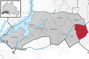
Lankwitz is the easternmost of the seven districts of the south-west of Berlin, located district of Steglitz-Zehlendorf .
Location and urban environment

With an area of around seven square kilometers, it borders the following districts of Berlin:
- in the north at Steglitz with the locality south end ,
- in the east at Mariendorf ,
- in the southeast at Marienfelde as well
- in the west at Lichterfelde .
The district extends for around three kilometers in both north-south and east-west directions.

Lankwitz is bounded in the north by the Teltow Canal , which in this area lies on the Lankwitz area. In the east and south, the district is determined by the border with the Tempelhof-Schöneberg district , which initially runs west of the railway tracks of the Dresden Railway . The Trachenbergring and Friedrichsrodaer Straße as well as the Kreuzkirchhof belong to Lankwitz. The border touches the southern ends of Tambacher Strasse and Tautenburger Strasse in a straight line and then crosses Tennstedter and Trippsteinstrasse in a straight line . The Hildburghauser and the Zerbster Straße are then already in the area of Lichterfelde . The border runs around the Lankwitz cemetery to the west , then follows Luisenstrasse , then crosses Lankwitzer Strasse , Anhalter Bahn and Bruno-Walter-Strasse. Finally, it runs along the east side of Gärtnerstrasse and the west side of Wiesenweg , where it then meets the border on the north side of the Teltow Canal in a straight line - east past the Steglitz harbor.

Lankwitz is mainly built up with single and multi-family houses. The oldest villas date from the 19th century. The geographical center of the district is in the Lankwitz community park . Lankwitz was an independent municipality until it was incorporated into Greater Berlin in 1920. The center today is the area between the Lankwitz S-Bahn station and the Dreifaltigkeitskirche (also called Lankwitz Church ), at which there is a junction for numerous bus routes from the south-west of Berlin. Today the district is mainly characterized by small housing estates. But there are also modern, around 20-storey high-rise buildings to the east of the center on Kamenzer Damm. The Berlin animal shelter , now in Falkenberg , was located in Lankwitz on Dessauerstrasse from 1901 to 2001. The Correns mansion , also known as Siemensvilla , is located in Gärtnerstraße , the former villa property of a member of the Siemens family , until 2010 the music archive of the German Library and today the location of the private universities BSP Business School Berlin Potsdam (University of Management) and the MSB Medical School Berlin (University of Health and Medicine).
History and Development


_Dorf_Lankwitz.JPG)
The village of Lankwitz emerged from a Slavic settlement in the shape of a horseshoe, the legs of which ended at the Lankegraben. The name goes back to the old Slavic Lankowice and means place on the river bank , cf. Lanke . It refers to the Wiesenbach Lanke , which once led through this place. The Lanke still exists, but is canalized throughout its course or merged into the Teltow Canal. The source is marked by the Lanke stone on the Ratswaage , at the corner of Charlottenstrasse and Elisabethstrasse . From there it flowed to the northeast via today's Bruchwitzstraße to Mühlenstraße , where it expanded to a pond that was popularly known as the carp pond . It enclosed the village in an eastern arch and flowed into the Lankwitz main ditch at the old Upstall (today: Teltow Canal). The trench ran the water in the muddy Birkbusch ( Birkbuschstrasse ) for the former and also largely risen in the Teltow Canal Bäke that the water over the Griebnitzsee the Havel charging thereto.
Lankwitz was first mentioned in a document in 1239: the oldest documentary mention of a village in today's urban area of Berlin. In 1239 Johann I. and his brother Otto III. the district of Lankwitz the Benedictine convent St. Marien zu Spandau , which belonged to the diocese of Brandenburg . The population consisted mainly of farmers. The village was mentioned as having 44 hooves , so it had already been measured ("heaped"), which indicates a German takeover before 1239.
The core of the Angerdorf Lankwitz is located in the northeast of the district. Originally it was an anger sack , which, located on the edge of a Slavic trade route along the Bäke between Teltow and Köpenick , was only accessible from the northwest and was otherwise surrounded by water and fields. This sacking was converted into a street green village in the 14th century , the green of which is still recognizable today as Alt-Lankwitz in the area of the Lankwitz village church .
The construction of the village church was related to the takeover of ownership by the Benedictine nuns from Spandau. With the arrival of German settlers, a wooden church will have been built as usual. Usually 30 years passed before a considerably more expensive stone church was built, until the settlers had saved enough money from the yields of the grain harvest. This time could be shortened in Lankwitz because of the assets of the monastery. The church was probably built around 1250.
Lankwitz is mentioned as a parish village in 1265. The land book of Charles IV shows 33 hooves for Lankwitz, four of which are parish hooves. The difference between 44 hooves (1239) and 33 hooves (1375) can probably be explained by the fact that eleven hooves were lying desolate , because in 1450 40 hooves are mentioned again. Later a church hoof was added to the parish hoof. In 1313 the first pastor of the Lankwitz community is mentioned in a document, Arnold Weyger, who came from the Kaland Brotherhood at the Benedictine convent Spandau and after today a street in Lankwitz is named. A jug and a Schulze are mentioned as early as 1375 for the village . There are five kossas that indicate the Slavic element .
In 1558, as a result of the Reformation , Lankwitz passed from the property of the monastery in Spandau to the property of the Spandau Office . In 1590 the Lehnschulzengut comprised four Lehnhufen and two Zinshufen. The Lehnschulzengut was owned by the von Pfuel family from 1786 .
The Brandenburg Elector Johann Georg ordered in 1574 that the Lankwitz Church should be run as a daughter church of Schöneberg . His successor Joachim Friedrich made the Lankwitz Church in 1602 a branch church of Schöneberg. The priest path between Alt-Schöneberg and Lankwitz was used by the Schöneberg priests to get to Lankwitz. In 1894 Lankwitz became an independent parish.
At the end of the 19th century, the so-called Rosenthalsche Viertel, northwest of the Lankwitz train station, was built with villas; today it is referred to as the composer's quarter because of the street names that predominate there . In the decades that followed, the Zietenmannsche Viertel followed south of the composers ' quarter , which was also known as the Klamottenviertel because of its simpler development . Even further south followed the Thuringian Quarter , which was called Kleinkleckersdorf in the Berlin vernacular because the expansion was slow.
On October 1, 1920, the municipality of Lankwitz , which had previously belonged to the Teltow district, was incorporated into Greater Berlin as a part of the Steglitz district . 1932 taught Ludwig Mies van der Rohe for the closure of the Bauhaus in Dessau in the Birkbuschstrasse in Lankwitz the Bauhaus Berlin as a private school of architecture one which, however, in 1933 after the seizure of power of the Nazis had to close.
On the night of August 23-24, 1943, the Lankwitz bombing night , the town hall, the Trinity Church, the village church , the castle, the Villa Louise, the yellow schoolhouse (Alt-Lankwitz primary school) and many other buildings were destroyed. When Allied air raids during the period of Lankwitzer bomb night until 4 September 1943 Lankwitz was destroyed around 85 percent. After the Second World War , all the vacant lots were gradually closed, so that today there are no agricultural land in Lankwitz and hardly any fallow land .
Since 2000, Lankwitz has been the easternmost part of the Steglitz-Zehlendorf district .
population
| year | Residents |
|---|---|
| 1866 | 341 |
| 1890 | 2,102 |
| 1900 | 4.111 |
| 1910 | 9,528 |
| 1919 | 12,397 |
| 1937 | 30,402 |
| year | Residents |
|---|---|
| 1945 | 10,557 |
| 1956 | 29,797 |
| 2005 | 40,613 |
| 2008 | 40,385 |
| 2010 | 40,939 |
| 2011 | 41,242 |
education

Lankwitz is a university location : On the campus of the Free University (FU), the site of the former University of Education (PH) in Malteserstraße, there are facilities of the Geosciences Department (Institute for Geography, Institute for Geology, the Interdisciplinary Center Ecosystem Dynamics in Central Asia and the Willy Scharnow Institute for Tourism ). In addition, the administration of the department and the geoscientific library with its map collection are located on the premises.
The Institute for Journalism and Communication Studies of the Free University of Berlin, which has since moved to Dahlem , was also located on the campus.
The campus in Lankwitz is connected to the main campus of the FU Berlin in Dahlem by the bus route X83. With its decentralized position, the campus in Lankwitz is comparable to the also decentralized Adlershof campus of the Humboldt University (HU).
Lankwitz has both the Beethoven-secondary school with a gymnasium and with the Brondby High School through a comprehensive school with Gymnasium upper level .
recreation

In Lankwitz there is next to several smaller parks, such as the Rose Garden designated Bernkastler place , the ten hectares large community park , a park with sports court, mini-golf course and game reserve . Furthermore, permanent garden colonies invite you to go for walks, the Lankwitz public pool as a leisure-oriented indoor pool for swimming and the Lankwitz ice rink in winter for ice skating and curling . There are also opportunities for numerous sporting activities, such as football, tennis and squash .
The Thalia cinema, which has existed since 1953, invites to films and occasional events.
The 45 kilometer long green main Berlin hiking trail number 05, the north-south path , crosses the district of Lankwitz from the Lankwitz bridge on Kamenzer Damm in the north to the Kreuz cemetery in the south.
traffic
Public transport
railroad
One of the oldest railway lines in Berlin is the Anhalter Bahn , built in 1841 . It also leads through Lankwitz. On December 1, 1895, the Lankwitz-Viktoriastraße railway stop was opened on today's Leonorenstraße (since May 20, 1937) with the decisive cooperation of the municipal councilor August Bruchwitz . On September 30, 1899, the station was renamed "Lankwitz".
Since 1951, the long-distance trains were on a detour via the Berlin outer ring headed to West Berlin thus to drive around and Lankwitz. With the construction of the Berlin Wall in 1961, the route at the city limits was completely interrupted.
Long-distance traffic was resumed on May 28, 2006. In this context, Lankwitz benefited in terms of traffic, because the nearby Lichterfelde Ost train station became a regional train station and many long-distance traffic connections can be reached more quickly via the new Südkreuz long-distance train station.
The idyllic character of a tranquil S-Bahn route that runs directly through the Lankwitz residential areas was lost. Today there are gray noise protection walls ( noise protection wall) on the route, which has now become a long-distance railway line again, expanded for speeds of up to 160 km / h .
Train

The Anhalter suburban railway with the Lankwitz station was created for separate suburban traffic, was electrified in 1903 as Berlin's first railway line, and in 1929 it was converted to the Berlin S-Bahn system, which is still used today . With the takeover of the S-Bahn from the Deutsche Reichsbahn by the BVG in 1984, the line was shut down. The bridge over Leonorenstrasse was torn down.
The S-Bahn was restarted in 1995. The single-track section over the Teltow Canal was extended to the south of Lankwitz station, so that the bridge and station were only rebuilt on a single track. Lankwitz thus owned the only single-track S-Bahn station in Berlin that ran every 10 minutes. The S25 line running here today runs from Teltow in the south via Lankwitz through the north-south tunnel to downtown Berlin and on to the terminus at Hennigsdorf in the north.
On the eastern edge of Lankwitz is the route of the Dresdener Bahn , on which the S-Bahn line S2 operates. It is planned to set up a breakpoint at the Lankwitz Bridge ( Kamenzer Damm ). Due to the current financial situation in Berlin, this project will be delayed indefinitely.
omnibus
Despite the S-Bahn, the bus is the most important form of public transport for most people in Lankwitz. The connection between Lankwitz and the Schloßstraße shopping street in Steglitz generates strong demand for the bus routes between Steglitz Town Hall and the Lankwitz transfer point Lankwitz Church . This section of the route is therefore used at frequent intervals by several lines (including metro buses and express buses ) and some of them have bus lanes.
The following bus lines go to or through Lankwitz:
- 181, 184, 187, 283, 284
- M82 (Waldsassener Straße - S + U Rathaus Steglitz )
- X83 (Nahariyastraße - Königin-Luise-Straße / Clayallee )
- N81, N84
Others
In the 1980s it was planned to build an extension of the U9 line of the Berlin subway . The standardized evaluation procedure resulted in the best cost-benefit ratio. For political reasons, however, the extension of the U8 line in Reinickendorf was brought forward. The extension of the U9 to Lankwitz S-Bahn station is still part of the urban development plan . Today, due to the high costs, it can be assumed that in the near future - apart from the U5 line, which is currently under construction - no new underground lines will be built in Berlin .
On July 16, 1900, Lankwitz was connected to the Berlin tram network with the opening of the white line (from 1902: Line IV) of the southern Berlin suburban railway from Tempelhof to Lichterfelde . On January 1, 1910, line 99 of the Great Berlin Tram, coming from Gesundbrunnen , took over the service. From April 14, 1924, line 96, coming from Friedrichstadt , took over the operation of the route; on October 8, 1930, it was extended to the Machnower lock . Tram traffic was stopped on May 2, 1966.
In the meantime there are considerations for the return of the tram to Steglitz . The trams could use the existing tunnels at Rathaus Steglitz and start at the underground station Schloßstraße at the directional platforms of the U9 line. This would enable a comfortable and weatherproof change to the U9. The rest of the route to Lankwitz would be based on today's bus route and could continue on to Marienfelde . Immediate implementation is not to be expected here either.
Private transport
The relatively heavy through traffic is problematic for some areas of Lankwitz . The cars and trucks that come from the southern Berlin area (such as the freight traffic center near Großbeeren ) drive through Lankwitz to get to Steglitz and the western districts of Berlin. The Paul-Schneider-Straße proves to be the bottleneck , as there is only one lane available in each direction and this often leads to traffic jams .
Plans originally envisaged that the federal road 101 , which runs from the city limits via Marienfelder Allee to Alt-Mariendorf , via Malteserstraße , Munsterdamm and Grazer Damm to the city ring at the Schöneberg interchange . To do this, a new street would have been necessary as an extension of Malteserstraße - past the primary school in Schulstraße - across the Teltow Canal at Edenkobener Weg to the corner of Steglitzer Damm and Munsterdamm. This street would have led through the middle of Lankwitz residential areas. North of the Teltow Canal, the buildings erected at the time have been included in the planned route since the mid-1960s. Over the years, resistance from local residents developed against this street. These plans are currently not being pursued.
The planned rapid cycle connection Teltow Canal Route will lead through Lankwitz, among other places.
Shipping
Lankwitz is connected to the waterway network. A connection to the Havel and Spree is established via the Teltow Canal (opened on June 2, 1906) . The port in Lankwitz is mainly used for handling oil. The resident companies supply numerous households in south-west Berlin with heating oil.
Drainage

In 1777, at the behest of the Prussian King Friedrich II, a drainage ditch was built from the Marienfelder Feldmark through Lankwitz and Giesensdorf to the Bäke in order to avoid the destruction of the harvests due to the water standing in the fields after extensive rainfall. This trench had numerous side arms and was named Königsgraben in honor of the king . The course of this trench can still be seen in many places, but today there is only a very few new, much smaller trenches left. In Lichtenrade , the Königsgraben is still well preserved and flows into the Freseteich there . Coming from the street An der Heilandsweide, the Königsgraben was on today's Hanielweg, crossed Malteserstraße (then: Marienfelder Straße ) on Marchandstraße and the transition between Gallwitzallee and Tautenburger Straße . In between there is now the Koenigsgraben allotment garden settlement. The moat on Waltershauser Strasse from Trippsteinstrasse to Geraer Strasse is the Okengraben , which is located directly south of the original and much larger Königsgraben. There you will find the elementary school at Königsgraben and a sports field. Today Geraer Strasse and the area south of the gravel road to the northwestern end of Grabenstrasse are located further along . After crossing under the Anhalter Bahn, the Königsgraben ran in a westerly direction and flowed into the Bäke in the area of the port of Lichterfelde.
The Bäke and the Lankwitz main ditch north of the village center are now connected by the Teltow Canal and are therefore no longer in their original state. Only remnants of the Lanke , which Lankwitz once gave its name, are preserved in the area directly south of the old village center.
After the heavy rainfalls in 1926/1927, large parts - especially of Lichtenrade - were under water for a long time. Then between August 1928 and November 1929 the ten kilometers - seven kilometers of which in the districts of Lichtenrade and Mariendorf - long underground drainage canal Lichtenrader-Lankwitzer rainwater collector (LiLaReSa) was built, the one west of the Lankwitz port and the Sievers Bridge into the Teltow Canal flows out and is still in operation today.
Existing flowing and standing waters
- Park pond ( location ): a 1910/1912 in Beyendorffpark (today: community park ) by Carl Rimann as an artificial park pond with an area of 4750 m² and 330 meters circumference.
- Lankegrabenteich and Lankegraben ( location ): It is located on the streets Alt-Lankwitz 58, Wedellstraße and In den neue Gärten in a green corridor and is fed by the Lankegraben. With an area of 780 m², it has an average depth of 1.15 meters and a maximum depth of two meters.
- Theodosiusteich ( location ): Located on the area at the Dominikus Monastery, it was created in the 1970s as an artificial pond with a concrete seal on an area of 500 m² and a maximum depth of two meters.
- Alter Upstall pond ( location ): Four ponds on the site of the former allotment garden facility Alter Upstall, which only periodically carry water, whereby the largest (No. 1) has an area of 145 m². The map of the Lankwitz district around 1846 shows the Upstall as a swampy meadow area. The ponds were probably created by the wallows.
- Okengraben ( location ): Side canal of the Königsgraben between Waltershauser Strasse and Trippsteinstrasse.
- Gas ditch ( location ): Former Lankwitz main ditch, recognizable in the old Upstall / Freymüllerweg with some ponds. No body of water in the sense of the Berlin Water Act.
- Hospitalgraben ( location ) in the course of the course of the Lanke.
- Fighting pit
- Königsgraben: A drainage ditch built in 1777 which never fulfilled its function. Today it is mainly known by name because of the elementary school at Königsgraben and the garden colony of the same name.
- The Teltow Canal lies between the Prinzregent-Ludwig-Brücke and in front of the railway bridge of the Dresdener Bahn on Lankwitzer Flur, whereby the Lankwitzer district boundary was to the north and included the main ditch with its swampy riverside area.
Important buildings and facilities
General
- Nursing and residential home of the Auguste Viktoria Hospital , Leonorenstrasse
- Berliner Synchron , one of the most important dubbing studios in Germany on Mühlenstrasse (moved to Schöneberg in 2017 , building was demolished in 2018)
- Vocational training center of the Landespostdirektion, Kaiser-Wilhelm-Straße
- Bürgeramt, Gallwitzallee
- Business School Berlin Potsdam , private university for management in the Siemensvilla on the corner of Calandrelli and Gärtnerstrasse
- Carl Voll Foundation, Friedrichrodaer Strasse
- Lankwitz ice rink, Leonorenstrasse
- Energy Museum Berlin , Teltowkanalstrasse
- Free University of Berlin , Lankwitz campus, Malteserstraße, formerly: Berlin University of Education
- Lankwitz House - Children's and Youth Home, Beethovenstrasse
- Cheese bell , colloquially for the Bernkastler Platz multi-storey car park (Rosengarten) , today: children, youth and family meeting place, Leonorenstraße (opposite the town hall)
- Medical School Berlin , private university for medicine and health in the Siemensvilla on the corner of Calandrelli and Gärtnerstrasse
- Police Directorate 4 - Section 46, Gallwitzallee
- Preussenstadion , corner of Malteserstraße / Kamenzer Damm, home stadium of BFC Preussen
- Psychiatric day clinic of the Theodor-Wenzel-Werk, Kamenzer Damm
- Lankwitz Town Hall , Leonorenstrasse, previously housed parts of the Steglitz-Zehlendorf tax office, now the social and sports department of the Steglitz-Zehlendorf district office
- Ratswaage Lankwitz , corner of Charlottenstrasse and Elisabethstrasse, women's meeting point of the Steglitz-Zehlendorf district office
- Retirement home, Gallwitzallee
- Retirement home, Malteserstrasse
- Leonorenstrasse sports facility (ice rink, field hockey, tennis)
- Stadtbad Lankwitz , Leonorenstrasse
- City library, Bruchwitzstrasse
- Technical relief organization , Gallwitzallee
Cheese bell opposite the town hall

Police Headquarters 4 - Section 46

City library

rink


Denominational institutions


Protestant
- Diakoniestation Lankwitz and Diakonieverein Lankwitz, Kaiser-Wilhelm-Straße
- Diakoniestiftung Lankwitz, Kaiser-Wilhelm-Strasse
- Dietrich Bonhoeffer Community Center , Geraer Strasse
- Dietrich Bonhoeffer Foundation, Sondershauser Strasse
- Lankwitz village church , Alt-Lankwitz
- Dreifaltigkeitskirche (Lankwitz Church) , Gallwitzallee
- Pastor Brown House, In the New Gardens
- Paul Schneider Community Center , Belßstrasse
Catholic
- Pastoral area Steglitz-Lankwitz-Dahlem
- Dominikuskloster , Alt-Lankwitz (Christ the King Sisters)
- St. Benedikt , Kaulbachstrasse
-
Pastoral area Lankwitz-Marienfelde
- Mater Dolorosa Berlin-Lankwitz , Kurfürstenstrasse
- St. Augustine Monastery , Gallwitzallee
- St. Marien Hospital , Gallwitzallee
- Maria Immaculata Foundation, Gallwitzallee
- Mater Dolorosa Foundation Berlin-Lankwitz , Kurfürstenstrasse
Others
- St. Immanuel ( Ethiopian Orthodox Tewahedo Church ), Kamenzer Damm
- Kreuzkirche ( Evangelical Methodist Church ), Zietenstrasse
- Church of Jesus Christ of Latter-day Saints ( Mormons ), Kaulbachstrasse
graveyards
- Dreifaltigkeitsfriedhof , Paul-Schneider-Strasse
- Lankwitz cemetery , Lange Straße ( Otto Lilienthal is buried here)
- Cross cemetery with children's burial site Tabea, Malteserstrasse
- Luther-Friedhof , Malteserstraße (the Berlin original Harfenjule is buried here)
schools
- Alt-Lankwitz primary school, Schulstrasse
- Beethoven-Oberschule (grammar school), Barbarastraße
- Brondby High School , Dessauerstrasse
- Elementary school at the Königsgraben (today the ditch is called Okengraben ), Gallwitzallee
- Ludwig Bechstein Primary School, Halbauer Weg
- Paul-Braune -Oberschule, Dessauerstraße
- Paul Schneider Primary School, Seydlitzstrasse
- Peter Frankenfeld School, Wedellstrasse
Personalities
- Heinz Barwich (1911–1966), nuclear physicist
- Martin Benrath (1926–2000), actor
- Rudolf Beyendorff (1876–1947), first mayor of Lankwitz (1908–1919)
- Wolfgang Brezinka (1928–2020), Professor of Education
- August Bruchwitz (1838–1914), local politician, councilor of the former Lankwitz community
- Moritz Cristopher (pseudonym: MC Bogy ; * 1979), musician
- Mithat Demirel (* 1978), national basketball player
- Friedrich Dillges (1852–1912), local politician, honorary community leader of the former community of Lankwitz
- Annemarie Dührssen (1916–1998), psychiatrist, psychoanalyst, psychotherapist, champion for the establishment of psychotherapy in the medical care system
- Hartmut Ebbing (* 1956), politician
- Fritz Freymüller (1882–1950), architect, urban planner and construction clerk; Municipal building councilor of the former Lankwitz municipality
- Günter Gerlach (1928–2003), church musician, school musician and composer
- Edgar Groß (1886–1970), theater scholar and artistic director
- Gert Günther Hoffmann (1929–1997), voice actor
- Wilhelm Hüffmeier (* 1941), Protestant theologian
- Hanna-Renate Laurien (1928–2010), politician
- Hermann Marchand (1864–1945), lawyer and urban developer
- Hanna Neumann (1914–1971), mathematician
- Jutta Neumann (* 1932), track and field athlete
- Arvo Pärt (* 1935), composer
- Maximilian Philipp (* 1994), soccer player
- Johannes Pinsk (1891–1957), Catholic theologian
- Marianne Rosenberg (* 1955), pop singer
- Wiltraut Rupp-von Brünneck (1912–1977), judge at the Federal Constitutional Court
- Barbara Saß-Viehweger (* 1943), politician and notary
- Ricardo Scott (pseudonym: Smoky ; * 1983), musician
- Alfred Seppelt (1929–2015), chess official
- Hajo Seppelt (* 1963), sports reporter
- Lorenz Weinrich (* 1929), historian
Others
- Lankwitz is also the German name of the Polish village Łękwica .
- The name of the West Styrian pilgrimage site Maria Lankowitz is also derived from Slavonic.
- In the Russee district of Kiel and in Hanover , a street with the name Lankwitzweg is named after the district. There is a Lankwitzer Weg each in Bielefeld and Monheim am Rhein .
- The district of Lankwitz ends at the eastern end of Kamenzer Damm at the Lankwitzer Bridge . Beyond the bridge on the Mariendorfer side, the street is then called Lankwitzer Straße .
- The street between Kranoldplatz at Berlin-Lichterfelde Ost train station and the northern end of Kurfürstenstrasse in Lankwitz is also called Lankwitzer Strasse .
- On October 5, 2007, the oldest living German , Irmgard von Stephani, died in Lankwitz at the age of 112.
- The Bernkastler court was appointed by the district authority of Steglitz-Zehlendorf to the monument of January 2017th
See also
- List of streets and squares in Berlin-Lankwitz
- List of cultural monuments in Berlin-Lankwitz
- List of stumbling blocks in Berlin-Lankwitz
literature
- Paul Hiller: Chronicle Lankwitz (= preprint . Volume No. 5/6). Word & Image Specials, Berlin 1989, ISBN 3-926578-19-X .
- Annelen Hölzner-Bautsch: 100 years of Mater Dolorosa Church - history of the Catholic community in Berlin-Lankwitz - 1912 to 2012 . Editor: Catholic Parish Mater Dolorosa, self-published, Berlin 2012 ( content )
Web links
- Stations Fancy going to Lankwitz district office Steglitz-Zehlendorf
- Local history of Lankwitz at Heimatverein Steglitz e. V.
- Jörg Opel's garden city of Lankwitz is so beautiful and green
Individual evidence
- ↑ Weygerweg. In: Street name lexicon of the Luisenstädtischer Bildungsverein (near Kaupert )
- ↑ Priest path . In: Street name lexicon of the Luisenstädtischer Bildungsverein (near Kaupert ) "The route used by the Schöneberg pastors to the branch village Lankwitz"
- ↑ Leonorenstrasse. In: Street name lexicon of the Luisenstädtischer Bildungsverein (near Kaupert )
- ↑ Lankwitz. In: stadtschnellbahn-berlin.de. Retrieved March 10, 2012 .
- ^ Wolfgang Kramer, Siegfried Münzinger: Southern Berlin suburban railway . In: Berliner Verkehrsblätter . Volume 6, 1963, pp. 59-61 .
- ^ Wolfgang Kramer, Siegfried Münzinger: Southern Berlin suburban railway . In: Berliner Verkehrsblätter . Issue 7, 1963, pp. 69-72 .
- ^ Heinz Jung, Wolfgang Kramer: Line chronicle of the Berlin tram 1902–1945. 59th episode . In: Berliner Verkehrsblätter . Volume 4, 1969, pp. 69-71 .
- ↑ Marcel Götze: Post-War History 1960–1969. In: Berlin-Straba.de. Retrieved January 25, 2016 .
- ↑ Marina Heimann: The LILARESA (Lichtenrader-Lankwitzer rainwater collector). At: lichtenrade.com , accessed on December 10, 2012.
- ↑ a b c d Steglitz-Zehlendorf Water Book ( Memento from January 13, 2016 in the Internet Archive ; PDF; 376 kB)
- ↑ a b Wolfgang Friese: The Teltow Canal in Lankwitz. In: Heimatverein Steglitz e. V. (Ed.): Steglitzer Heimat , vol. 51, No. 2, Berlin 2006, pp. 21-25.
- ↑ Christ the King Sisters, orden-online.de, accessed on October 9, 2017
- ^ Georg Holzer: Slavonic - The Slavia submersa . (PDF) 2005, accessed on April 21, 2016
- ↑ The oldest German lives in Lankwitz . In: Die Welt , September 21, 2005.
- ↑ Irmgard von Stephani (born 1895) - “Age comes by itself.” . In: Der Tagesspiegel , October 26, 2007.
