
List of streets and squares in Berlin-Marienfelde

The list of streets and squares in Berlin-Marienfelde is a summary of the in the Berlin district of Marienfelde in Tempelhof-Schöneberg existing historically or currently streets and squares. At the same time, this compilation is one of the lists of all Berlin streets and squares .
overview

Marienfelde has 32,349 inhabitants (as of December 30, 2019) and includes the postcode areas 12277, 12279, 12249. According to the official street directory, the district has 114 dedicated streets. The public road network in the district is 52.9 kilometers, but paths in colonies and private roads are ignored.
The federal road 101 leads through the district along Großbeerenstraße ( coming from Kreuzberg ) and Marienfelder Allee . The main road system is supplemented by Malteser Straße from Lankwitz and the streets Säntisstraße and Motzener Straße across Buckower Damm , as well as Daimlerstraße and Richard-Tauber-Damm with a connection to Buckower Damm. The system of main roads is completed by the east-west streets Hildburger Straße , Nahmitzer Damm and Buckower Chaussee, which gained importance as a southern peripheral and bypass road after the building of the wall and was developed as a connection between the B 96 and Zehlendorf . After the fall of the Wall, Marienfelder Allee was expanded as the B 101 with two two-lane lanes as a connection to southern Brandenburg . After its expansion in the 2010s, the B 101 is also available as a motorway feeder to the Berliner Ring . The Marienfelder Allee as a road to Großbeeren was classified as a district road until the formation of Greater Berlin in 1920. Its importance was already in 1865 in connecting the Berlin-Cottbuser with the Potsdam-Großbeerener Staatsstraße. In several Marienfeld street names, “Damm” stands for special measures to guide roads in damp terrain. After the villa colony near Marienfelde train station , the streets of the suburban settlement in the south around Marienfelder Allee were built on around 1934.
"With the commissioning of the Teltow Canal in 1906 and the associated industrial settlement, Tempelhof, Mariendorf and Marienfelde also began an economic upward trend, an increase in population and, as a result, a stronger connection to Berlin."
The only tram route in Marienfelde ran in the far northeast through Großbeerenstraße and Daimlerstraße. It was put into operation on November 19, 1925 and initially served by line 199 coming from Niederschönhausen . From 1938 line 15 in the direction of Neukölln added to the offer. On July 1, 1966, the route was set. The trolleybus line A32 ran from 1935 to 1965 from Steglitz via Malteserstraße and Marienfelder Allee to Marienfelde station.
In the district, a comparatively large number of streets continue across the district boundary. The creation of satellite districts and changed street layouts also resulted in a renaming or the creation of spur streets at the ends of the streets. Malteserstraße and Marienfelder Allee do not cross directly, but end as dead ends while the intersection is a little further west between Hildburghauser and Friedenfelser Straße and street 427 leads to Marienfelder Allee.
" Marienfelde , parish village in the Teltowschen Kreis, 1 1 ⁄ 2 M [eilen] from Berlin, and 1 ⁄ 2 M behind the previous village [Mariendorf] on the road to Groß-Beeren , has 260 inhabitants."
Overview of streets and squares
The following table gives an overview of the streets and squares in the district as well as some related information.
- Name / location : current name of the street or square. Via the link Location , the street or the square can be displayed on various map services. The geoposition indicates the approximate center of the street length.
- Traffic routes not listed in the official street directory are marked with * .
- Former or no longer valid street names are in italics . A separate list may be available for important former streets or historical street names.
-
Length / dimensions in meters:
The length information contained in the overview are rounded overview values that were determined in Google Earth using the local scale. They are used for comparison purposes and, if official values are known, are exchanged and marked separately.
For squares, the dimensions are given in the form a × b for rectangular systems and for (approximately) triangular systems as a × b × c with a as the longest side.
If the street continues into neighboring districts, the addition ' in the district ' indicates how long the street section within the district of this article is. - Name origin : origin or reference of the name.
- Notes : further information on adjacent monuments or institutions, the history of the street and historical names.
- Image : Photo of the street or an adjacent object.
| Name / location | Length / dimensions (in meters) |
Origin of name | Date of designation | Remarks | image |
|---|---|---|---|---|---|
|
Ahrensdorfer Strasse
( Location ) |
340 | Ahrensdorf , town in the Teltow-Fläming district | Apr 5, 1934 | The street lies between Tirschenreuther Ring and Marienfelder Allee (to which it does not lead). Before 1914, it was designated as Osdorfer Weg up to the city limits. On April 1, 1971, the western part was renamed to Waldsassener Strasse with road 426 and the middle part to Pfabener Weg. From there (Wiesauer Straße) to the remaining part there is a park with sports facilities. On October 1, 1973, Strasse 460 was incorporated into Ahrensdorfer Strasse. |
.JPG)
|
| Albanstrasse
( Location ) |
390 | Ernst Alban (1791–1856), physician and engineer | Aug 4, 1930 | The street lies between Wehnertstrasse and Säntisstrasse south of the railway line as an extension of the Bahnstrasse. |

|
| Old Marienfelde
( Location ) |
660 | The old town center of Marienfelde | Aug 31, 1949 | The historic village street of the Angerdorf around the 1220 (oldest Berlin) village church was renamed as in other districts with the prefix "Old-". The town center around Alt-Marienfelde is a listed building ensemble . |

|
| At the Horstenstein
( Location ) |
290 | Horstenstein: Pfarracker and Vorwerk in Marienfelde | Feb 13, 1957 | Horstenstein was first mentioned in 1839 as the Vorwerk of the von Beyer and belonged to Gut Marienfelde . In 1858 15 people lived there, in 1861 there were two residential and two farm buildings. The Horst Steiner Street was the road between Vorwerk and property. The current street, previously set up as street 300 , is located between Tullaweg and Wehnertstraße. |
.JPG)
|
| At the monastery gardens
( Location ) |
270 | After the gardens of the monastery "Of the Good Shepherd" | March 15, 1978 | A road that goes south from Hanielweg and continues as a footpath to Malteser Straße. |
.JPG)
|
| At the village church
( Location ) |
140 | After the village church on the village green | Oct 15, 1970 | The Kirchstrasse was separated by the construction of the sports field, so the southern part, a cul-de-sac from Alt-Marienfelde, was renamed. |

|
| At the Savior's Pasture
( Location ) |
770 | after the white willow and its legend | Nov 1, 1953 | The white willow on the dirt road to Horstenstein was rotten and in 1952 a new tree was planted. The street lies between Marienfelder Allee and Greulichstraße, a footpath and bike path of the same name leads to Wehnertstraße. |

|
|
Bahnstrasse
( Location ) |
540 | Marienfelde station since 1875 | 1900 to 1903 | The street runs south of the railway line between Marienfelder Allee and Wehnertstraße. |
 _Eisenbahn_Geschwindigkeits_Weltrekord2.JPG)
|
| Barlachweg
( Location ) |
100 | Ernst Barlach (1870–1938), sculptor and graphic artist | Feb. 1, 1966 | Set up as street 423 , it is a cul-de-sac between Tullaweg and the adjacent sports field. |
.JPG)
|
| Baußnernweg
( Location ) |
260 | Waldemar Edler von Baußnern (1866–1931), composer | Dec 13, 1934 | Established as street 109 , it lies between Kronstädter Weg and Marienfelder Chaussee. She crosses the Manntzgraben . |
.JPG)
|
| Belßstrasse
( Location ) |
440 (in the district) |
Frank Belß (1841-1919), Marienfeld local politician | July 31, 1947 | The street is between Marienfelder Allee / Bahnstraße and Malteser Straße in Lankwitz . The district boundary is on the east side of Friedrichrodaer Straße. The entire complex of the "Mariengarten" settlement is a listed building ensemble. |
.JPG) _Moritz_Jacobsohn.jpg)
|
| Benzstrasse
( Location ) |
550 | Carl Benz (1844–1929), engineer and car pioneer | Aug 4, 1930 | An unnamed cul-de-sac from Daimlerstrasse parallel to Martiusweg was named in the dedication. During renovations north of Säntisstraße, the route changed and on February 13, 1957, Industriestraße and a newly built street were included in Benzstraße. It is located between the trade on the railway embankment and Daimlerstrasse. |

|
| Beyrodtstrasse
( Location ) |
780 | Otto Beyrodt (1870–1923), local politician | July 26, 1927 | Another part of the previous street 172 was incorporated on August 4, 1930, it is located between Emilienstraße and Hanielweg. |

|
| Bistritz Path
( Location ) |
140 | Bistritz , city in Transylvania (Romania) | Apr 4, 1934 | Set up as road 108 , it is a cul-de-sac on both sides of the Klausenburgerpfad, south to the city limits (Mauerweg) to the north the Manntzgraben continues. |
.JPG)
|
| Bleichertstrasse
( Location ) |
410 | Adolf Bleichert (1845–1901), entrepreneur of the largest cable car factory | Nov 23, 1933 | The street 42 and street 43 were renamed, on February 1st, 1968 the street 443 and the part of the Kaiserallee up to the Kirchstraße were included. The street lies between Hranitzky and Kirchstrasse. House 35 was designed by the architect Möhring. |

|
| Blohmstrasse
( Location ) |
80 (in the district) |
Hermann Blohm (1848–1930), co-founder of Blohm + Voss | Aug 4, 1930 | Marienfelde is only a short section west of Egestorffstrasse, which continues as a hiking trail. By far the largest part of the street lies between Egestorffstrasse and Erich-Hermann-Platz in Lichtenrade , where Viktoriastrasse there was incorporated in 1957. |
.JPG)
|
| Brandaustrasse
( Location ) |
450 | Karl Brandau (1849–1917), railway civil engineer | Aug 4, 1930 | The previous street 9 is between Daimlerstrasse and Säntisstrasse. |
.JPG)
|
| Bruno-Möhring-Strasse
( Location ) |
340 | Bruno Möhring (1863–1929), architect and designer of Art Nouveau | Sep 1 1973 | Named as a parallel street before 1904 , it lies between Belßstrasse and Hranitzkystrasse. |

|
| Buckower Chaussee
( Location ) |
680 (in the district) |
Connection path to the neighboring town of Buckow | after 1907 | The historic route to Buckow lies between Alt-Marienfelde / Säntisstrasse and the border with Lichtenrade , it continues to Lichtenrader Damm and as Marienfelder Chaussee to Buckow. |

|
|
Culemeyerstrasse
( Location ) |
120 | Johann Culemeyer , (1883–1951), engineer, known for the heavy-duty road vehicle of his name | Nov 4, 1976 | Culemeyerstraße was a private public transport road to the Marienfelde freight yard. The designation was made at the suggestion of the Reichsbahn Vermögensamt and announced on November 4, 1976. It is a dead end street west of Richard-Tauber-Damm. |
.JPG)
|
|
Daimlerstrasse
( Location ) |
810 (in the district) |
Gottlieb Daimler (1834–1900), designer and entrepreneur | March 23, 1925 | The street lies between Säntisstrasse and Großbeerenstrasse, in the eastern part the north side does not belong to the district. Laid out as Straße 130 , it led to Säntisstraße in 1929 and to Kettinger Straße in 1938 and was included between 1929 and 1935. On July 1, 1977, after a route change, the Mariendorfer part between Grimmingweg and Kettinger Straße was renamed Föttingerzeile.
Monument: machine factory Fritz-Werner-Werk. Until 1966 the only tram line in Marienfelde ran through the western Daimlerstraße. The former turning loop at the corner of Birnhornweg was paved for use by buses and its location can still be seen in the cityscape today. |

|
| Diedersdorfer Weg
( Location ) |
1490 | Diedersdorf , town in the Teltow-Fläming district (Brandenburg) | before 1930 | The Diedersdorfer Weg was named between 1929 and 1930 and lies between Marienfelder Allee and Tilkeroder Weg up to the city limits to the east around the Marienfelde suburb. |
.JPG)
|
| Domagkstrasse
( Location ) |
250 | Gerhard Domagk (1895–1964) bacteriologist and winner of the Nobel Prize for Medicine in 1939 | Apr. 24, 1969 | The previous street 406 is between Marienfelder Allee and Kirchstraße. |

|
| Dr. Jacobsohn Promenade
( Location ) |
290 | Moritz Jacobsohn (1880–1961), Jewish physician in Marienfelde | Apr 25, 1991 | The pedestrian and cycle path is between Maximilian-Kaller- and Friedenfelser Straße, it was previously part of Straße 427 . |
.JPG) 
|
|
Egestorffstrasse
( Location ) |
280 (in the district) |
Georg Egestorff (1802–1868), industrialist | around 1931 | The street in extension of Motzener Straße lies between Schichauweg and Dinnendahlstraße in Marienfelde, but without the eastern buildings and their side streets. It continues in Lankwitz . In June 1929 the development plan for this Marienfeld terrain was presented. On January 30, 1933, the street name was corrected from Egerstorff- to Egestorffstraße. On April 1, 1969, the section between Poleigrund and Schichauweg was renamed Motzener Straße. |
.JPG)
|
| Emilienstraße
( Location ) |
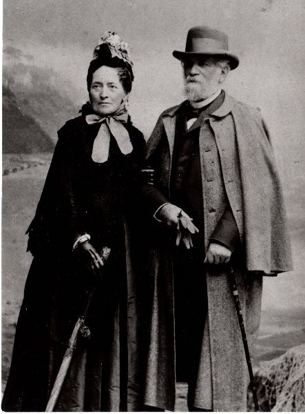
450 | Emilie Henriette Kiepert, b. Beer, (1824–1901), wife of the landowner | before 1905 | The Marienfelde country house at Emilienstraße 17, a monument, was built by the Art Nouveau architect Bruno Möhring for the then Benz director Karl Schippert. The street lies between Kiepertplatz and Welterpfad. |

|
| Erbendorfer way
( Location ) |
170 | Erbendorf , town in the Tirschenreuth district (Bavaria) | Dec. 1, 1970 | The previous street 459 is a dead end from Tirschenreuther Ring and connects the high-rise buildings. |
.JPG)
|
| Estersstrasse
( Location ) |
180 | Karl Esters (1873–1927), local politician, general department for the Rieselgüter in Berlin | Aug 4, 1930 | The street lies between Belßstrasse and Emilienstrasse. As early as 1907, not far east of today's Estersstraße, the garden side with land that was already built on at that time was located. The street itself, planned as Street 177 , was built in 1930. The entire western side of the street was built on around 1933 with houses of the "Gemeinnützige Baugesellschaft Mariengarten", but unlike the houses built at the same time in the neighboring street, it is not a listed building. |

|
|
Fleschweg
( Location ) |
170 | Hans Flesch (1896–1944), physician and radio pioneer, victim of the Nazi regime | July 1, 1970 | Set up as street 7 , it is located between Mauserstraße and Hossauer Weg. |

|
|
Föttingerzeile
( Location ) |
170 (in the district) |
Hermann Föttinger (1877–1945), electrical engineer, inventor of the Föttinger coupling | July 1, 1977 | In the course of the redesign in the course of Daimlerstrasse, a part was built over and the part between Grimmingweg and Kettinger Strasse was renamed in 1977. The north side of the line except for plot 40 belongs to Mariendorf and opposite plot 24 is the border to the district of Lichterfelde . |
.JPG)
|
| Friedenfelser Strasse
( Location ) |
350 | Friedenfels , municipality in the Tirschenreuth district (Bavaria) | Aug 15, 1990 | The street 481 was renamed in 1990 in Friedenfelser Strasse. When the Nahmitzer Damm / Marienfelder Allee intersection was redesigned, the street between the remote parts of Malteser Strasse (north) and Marienfelder Allee (south of the intersection) was renamed. On January 30th, 2009 the road 490 was included. |

|
| Friedrichrodaer Strasse
( Location ) |
960 (in the district) |
Friedrichroda , town in the district of Gotha (Thuringia) | Oct. 20, 1932 | The street lies between Keffenbrinkweg and Malteserstraße, but only the east side up to Trachenbergstraße belongs to Marienfelde, the eastern property boundary is the border to Lankwitz . On October 1, 1963, the Lankwitz section of Kiepertstrasse between Malteserstrasse and Friedrichrodaer Strasse was included. |
.JPG)
|
| Friesdorfer path ( location ) | 220 | Friesdorf , district of Mansfeld (Saxony-Anhalt) | Oct 19, 1934 | Established as Straße 128 , it lies between Wippraer Weg and Meisdorferpfad / Hermeroder Weg in the suburbs. |
.JPG)
|
| Fritz-Werner-Strasse
( Location ) |
380 (in the district) |
Fritz Werner (1865–1939), company founder of a machine factory in Marienfelde | March 23, 1925 | The street, previously known as Straße 72 , lies between Mariendorfer Friedenstraße and Daimlerstraße, the part from Untertürkheimer Straße (district boundary ) through the industrial area to Daimlerstraße belongs to the district.
Monument: machine factory Fritz-Werner-Werk |
.JPG)
|
| Fuchsmühler way
( Location ) |
300 | Fuchsmühl , market and resort in the Tirschenreuth district (Bavaria) | Nov 15, 2006 | Previously named road 461 , it lies between Pfabener and Baußner Weg. Although it is continuously paved with a single lane with a green verge, it is marked as a cul-de-sac on both sides. The street sign was unveiled on March 1, 2007. |
.JPG)
|
|
Gebertstrasse
( Location ) |
250 | Gebert, family of mill owners in Marienfelde | Feb 13, 1957 | A Marienfeld mill is mentioned in the local chronicles as early as 1373. Set up as Straße 40 , it is located between Intzestraße and Sameiskystraße. |
.JPG)
|
| Greizer Strasse
( Location ) |
310 | Greiz , district town in Thuringia | Aug 1, 1965 | The street 147 and street 442 were renamed together. It lies in the arch between Stadtilmer Weg and Kruseweg. |
.JPG)
|
| Greulichstrasse
( Location ) |
840 | Friedrich Greulich (1865–1946), bricklayer and local politician | Apr 20, 1948 | Named as Adolfstraße before 1902 , it was named after the unpaid SPD city councilor in Tempelhof after the Second World War . It is located between Kiepertplatz and Domagkstraße. |

|
| Grillostrasse
( Location ) |
400 | Friedrich Grillo (1825–1888), industrialist in the Ruhr area | Aug 4, 1930 | Set up as Straße 47, it is located between Albanstraße and Scheideggweg / corner of Säntisstraße. |

|
| Großbeerenstrasse
( Location ) |
320 (in the district) |
Großbeeren , municipality in the district of Teltow-Fläming (Brandenburg), destination of the road | before 1905 | The former military and trade route from Berlin via Marienfelde to Großbeeren is not yet shown under its current name in 1900, but in 1905 for the district of Mariendorf-Südende. The street lies between the Mariendorfer Ringstrasse and Rathausstrasse and the Dresdener Bahn at the Karl-Theodor-Schmitz-Brücke, here it turns into Marienfelder Allee. It is part of the federal highway 101 . Property 174/184 on the western side of the street already belongs to Marienfelde, 169a on the east side does not yet. |
.JPG)
|
|
Hanielweg
( Location ) |
580 | Franz Haniel (1779–1868), entrepreneur in the Ruhr area | Aug 4, 1930 | Named as Straße 143 in Marienfelde 1930, the extension of Straße 68a in Lankwitz was included on March 11, 1937. The path is between Marienfelder Allee and Pappritzstraße, the section up to Friedrichrodaer Straße in Marienfelde. |
.JPG)
|
| Hermannstadt way
( Location ) |
360 | Sibiu , city in Transylvania (Romania) | Apr 4, 1934 | It is laid out as a private road 110 between Baußnereg and over the Klausenburger path as a cul-de-sac to the city limits. |
.JPG)
|
| Hermeroder Weg
( Location ) |
370 | Hermerode , district of Mansfeld (Saxony-Anhalt) | July 13, 1934 | The path is laid out as road 129 and lies between Friesdorfer path and Tilkeroder path. |
.JPG)
|
| Hildburghauser Strasse
( Location ) |
1200 (in the district) |
Hildburghausen , district town in Thuringia | Aug 20, 1917 | The street was initially named in Lankwitz . In 1933 Marienfelder Strasse in Lichterfelde and Lichterfelder Strasse in Mariendorf were included. On August 1, 1965, the Lichterfelder Ring was also included until April 21, 1932 Lichterfelder Strasse. The street is between Osdorfer Straße (interrupted by the S-Bahn station) and the old route of Marienfelder Allee (across the intersection with Friedenfelser Straße), the district boundary is on Altenburger Straße (Lankwitz). |

|
| Hirzerweg
( Location ) |
290 (in the district) |
Hirzer , summit of the Sarntal Alps in South Tyrol (Italy) | Aug 4, 1930 | The path is referred to as Straße 133 in the development plan , it is located between Freibergstraße and Daimlerstraße in Mariendorf , only the west side between Unterthürkheimer and Titlisstraße belongs to Marienfelde. |
.JPG)
|
| Hollabergweg
( Location ) |
520 (in the district) |
According to Kauperts, named after Hollaberg, a 773 meter high mountain in the Bavarian Forest near Weißenstein (Regen) . However, it is called "Hollerberg", at least according to today's spelling, whereas there is a "Hollaberg" only in Austria. | Aug 4, 1930 | Hollabergweg, before street 112 , was named in 1930 and led in Mariendorf from Titlisstraße to the suburbs on Daimlerstraße. On January 24, 1938, it was extended to Marienfelde to Fleschweg (before: Straße 7 ). The tram turned between Birnhornweg and Daimlerstraße until 1966, since the conversion to a bus turning point (lower picture), Hollabergweg is only a narrow footpath at this point (in front of the fence on the right edge of the picture). |

|
| Hossauerweg
( Location ) |
580 | Johann George Hossauer (1794–1874), entrepreneur and inventor | Aug 4, 1930 | Established as Straße 4 , it was named in 1930 and on February 13, 1957, part of Industriestraße was included. It lies between Daimlerstrasse and Säntisstrasse. |

|
| Hranitzkystrasse
( Location ) |
800 | Alexander Hranitzky (1831–1905) owned a local tree nursery | before 1905 | Hranitzky developed a site acquired by Adolf Kiepert and in 1888 founded the "Neu-Marienfelde" colony. In 1905 the street ran between Marienfelder Allee and Bahnstraße, until 1938 it was extended in stages to the district boundary on Friedrichrodaer Straße.
Bahnstrasse and Bleichertstrasse to Friedrichrodaer Strasse and Wichurastrasse. |

|
|
Imhoffweg
( Location ) |
160 | Karl Imhoff (1876–1965), civil engineer, developed the Emscher fountain | Feb. 1, 1994 | Laid out as road 467 near the sewage treatment plant, it opens up residential property from Schichauweg northwards. |

|
| Intzestrasse
( Location ) |
350 | Otto Intze (1843–1904), inventor of the Intze principle | Nov 3, 1938 | Laid out as Straße 38 , it lies between Wehnertstraße and Tullaweg. At both end streets it continues as a cul-de-sac. |
.JPG)
|
|
Kaiserallee
( Location ) |
830 | Wilhelm II. (1859–1941), German Emperor | before 1905 | The street was already listed in 1905 and lies between the church and the town limits on Friedrichrodaer Straße. |

|
| Kiepertplatz
( Location ) |
90 × 30 | Adolf Kiepert (1820–1892), owner of the Marienfeld manor and local politician | before 1905 | The square is between Bahnstrasse, Emilienstrasse, Kiepertstrasse and Greulichstrasse. The trolleybus line A32 ran from 1935 to 1965 via Kiepertplatz in the direction of Marienfelde station, then as a normal bus line until the mid-1980s. |

|
| Kiepertstrasse
( Location ) |
660 | Adolf Kiepert (1820–1892), owner of the Marienfeld manor and local politician | before 1905 | Established before 1905, the section between Welterpfad and Friedrichrodaer Strasse was included on October 20, 1932, up to the World Heritage Trail and on December 1, 1963. It is not continuous from Kiepertplatz to Marienfelder Allee. |

|
| Kirchstrasse
( Location ) |
830 | After the village church built around 1220 | before 1900 | It is located between Bahnstrasse and Domagkstrasse, it was interrupted in 1970 by the construction of a sports field, the southern part to Alt-Marienfelde was named An der Dorfkirche. |

|
| Klausenburger path
( Location ) |
450 | Cluj-Napoca , city in Transylvania (Romania) | Apr 4, 1934 | Set up as street 121 , it is a traffic-calmed zone between Kronstadter Weg and Marienfelder Allee with a connection to the avenue. |
.JPG)
|
| Kronstadt way
( Location ) |
380 | Kronstadt , city in southern Transylvania (Romania) | Apr 4, 1934 | Previously set up as road 112 , it connects to the Fuchsmühler Weg as a private road and runs (via the Klausenburger path) to the city limits as a strait to the Mauerweg. |
.JPG)
|
| Kruseweg
( Location ) |
300 | Bruno Kruse (1855–1934), sculptor, created bronze figures and marble busts and was involved in the Niederwald monument as an employee of Schilling | Nov 1, 1953 | It is laid out as street 148 between Hildburghauser Straße and Lichtenfelder Ring. Kruse is buried in the Marienfelde cemetery. |
.JPG)
|
|
Lichterfelder Ring
( Location ) |
300 (in the district) |
Lichterfelde , neighboring town | Apr 21, 1932 | The ring connected Marienfelde and Lichterfelde as a land route . Under this name, the Landweg located in Lichterfelde, the Teltower Weg and part of the Lichterfelder Straße were combined in Marienfelde and on August 1, 1965 a part was incorporated into Hildburghauser Straße. In the district it is between Waldsassener Straße and in front of the beginning of the settlement on Lechtaler Weg. |
.JPG)
|
| Luckeweg
( Location ) |
530 | August Ferdinand Lucke (1845–1906), local politician and worked at Kiepert for the Marienfelde community | Apr 1, 1953 | The extension of Straße 447 was also included as Straße 130 on July 1, 1976 ; it is located on Manntzgraben between Ahrensdorfer Straße and in the arch to Tirschenreuther Ring. |
.JPG)
|
|
Malteserstrasse
( Location ) |
750 (in the district) |
Order of Malta , Catholic knightly order | July 21, 1960 | The street lies between the Lankwitzer Mühlenstraße and ends as a dead end in front of the street 427. The Lankwitzstraße in Marienfelde and the Marienfelder Straße in Lankwitz were renamed Malteserstraße in 1960. BD: Monastery and church by Josef Lückerath (1903–1905). |
.JPG)
|
| Manntzstrasse
( Location ) |
190 | Ferdinand Manntz (1838–1915), farmer and community leader, the only honorary citizen of the Marienfelde community | July 27, 1927 | Set up as Straße 173 , it is located between Kaiserallee and Hanielweg. |
.JPG)
|
| Marienfelder Allee
( Location ) |
1380 | As an avenue in the north-south route through Marienfelde | Aug 31, 1949 | In 1907 it was called Chausseestrasse, before 1912 it was renamed Berliner Strasse. The Greater Berlin Act brought it to Berlin, where there were now several Berlin streets, which in 1949 led to another renaming. It is part of the federal highway 101 and lies between Großbeerenstraße, with which it is connected by an underpass built in 1978, and the city limits. In the area of the Nahmitzer Damm intersection, road traffic has been routed a few meters further west on other streets since around 1987. |

|
| Martiusweg
( Location ) |
290 | Carl Alexander von Martius (1838–1920), chemist, co-founder of the corporation for aniline production ( Agfa ) in Treptow in 1872 | Aug 4, 1930 | Created as street 2 , it is located between Brandaustrasse and Benzstrasse. |

|
| Mauserstrasse
( Location ) |
730 | Paul von Mauser (1838–1914), weapons designer and manufacturer | Aug 4, 1930 | Laid out as Straße 8 , it is Daimlerstraße and Säntisstraße. |
.JPG)
|
| Maximilian-Kaller-Strasse
( Location ) |
410 | Maximilian Kaller (1880–1947), theologian, Bishop of Warmia and special papal representative for the displaced Germans | Oct. 1, 1973 | As part of Straße 427 , it joins the Dr.-Jacobsohn-Promenade as a cul-de-sac and leads to the Lankwitzer Tautenburger Straße as far as the district boundary. |
.JPG)
|
| Meisdorf path
( Location ) |
290 | Meisdorf , place in the Harz foreland | July 13, 1934 | Set up as street 127 in the suburb of Marienfelde, other streets are named after villages in the Harz region. It lies between the Friesdorfer path and Tilkeroder path. |
.JPG)
|
| Messmerstrasse
( Location ) |
310 | Jacob Friedrich Meßmer (1809–1881), engineer and designer | Nov 3, 1938 | Laid out as road 48 , it lies between Stegerwaldstrasse and Prechtlstrasse. |
.JPG)
|
| Miethepfad
( Location ) |
220 | Adolf Miethe (1862–1927), photo chemist and pioneer of photo technology | Apr 1, 1975 | The previous Lichterfelder Straße 51 was renamed and on February 1, 1994 Straße 489 in Marienfelde was included. In the district there is only this spur road north of the Poleigrund up to the footpath through the railway, as well as all land on the railway side up to the Schichauweg without the street itself. |

|
| Motzener Strasse
( Location ) |
240 partially only west side |
Motzen , place in the district of Dahme-Spreewald (Brandenburg) | Jan. 1, 1963 | The Lichtenrader Weg was named between 1918 and September 1925 and renamed in 1963, on April 1, 1969 a newly laid road between Motzener Straße and Poleigrund and a section of Egestorffstraße were included. The street lies between Buckower Chaussee and Schichauweg, the western part of the street and the properties from Poleigrund belong to Lichtenrade. In the northern part, a ring road into the industrial park has the same name.
Worth mentioning is the Semperlux Company's Historical Lighting Museum at Motzener Straße 34. |

|
|
Nahmitzer dam
( Location ) |
1080 | Nahmitz , place in the district of Potsdam-Mittelmark (Brandenburg) | July 1, 1973 | Laid out as road 473 , it lies between the bend in Buckower Damm and Marienfelder Allee (east of the Hildburghauser / Friedenfelser Strasse intersection); it leads south around the village of Alt-Marienfelde as a three-lane road with two lanes. |

|
| Nikolaus-Bares-Weg
( Location ) |
250 | Nikolaus Bares (1871–1935), Bishop of Hildesheim and Berlin, Catholic theologian | Apr 1, 1973 | A northeastern dead end from Maximilian-Kaller-Straße |
.JPG)
|
| Nunsdorfer Ring
( Location ) |
820 | Nunsdorf , place in the district of Teltow-Fläming (Brandenburg) | Sep 1 1968 | Created as Straße 457 , it is a ring road east of and to Motzener Straße. |
.JPG)
|
|
Pansfelder Weg
( Location ) |
460 | Pansfelde , district of Falkenstein / Harz (Saxony-Anhalt) | July 13, 1934 | Laid out as road 125 , it lies between Wippraer and Tilkeroder Weg. |
.JPG)
|
| Pfabener way
( Location ) |
200 | Pfaben , district of Erbendorf belongs to the Tirschenreuth district (Bavaria) | Oct. 1, 1971 | The street 462 was merged with part of the Ahrensdorfer Straße and named. It lies between Waldsassener and Wiesauer Straße. |
.JPG)
|
| Polegrund
( Location ) |
410 only north half of the street |
old field name of the local high moor | Nov 1, 1953 | Laid out as street 92 , it is located between Miethepfad and Motzener Straße. The district boundary to Lichterfelde runs in the middle of the street, only the northern side belongs to Marienfelde. |

|
| Prechtlstrasse
( Location ) |
200 | Johann Joseph von Prechtl (1778–1854), natural scientist, founding member of the Academy of Sciences in Berlin | Sep 1 1962 | Set up as Strasse 36 , it is located between Wehnertstrasse and Meßmerstrasse. |
.JPG)
|
| Pressburg path
( Location ) |
130 | Pressburg , capital of the Slovak Republic | Apr 4, 1934 | The road lies between Kronstadter and Hermannstadter Weg. There is no continuation to Marienfelder Allee. |
.JPG)
|
| Proellstrasse
( Location ) |
310 | Wilhelm Rudolf Proell (1845–1892), designer, development of regulators | Jan. 18, 1936 | Laid out as road 45 , it lies between Stegerwaldstrasse and Prechtlstrasse. |
.JPG)
|
|
Reinstedter way
( Location ) |
550 | Reinstedt , place in the district of Aschersleben-Staßfurt (Saxony-Anhalt) | July 13, 1934 | It is laid out as road 132 and lies between Marienfelder Allee and ( not continuously ) Diedersdorfer Weg. |
.JPG)
|
| Richard-Tauber-Dam
( Location ) |
870 | Richard Tauber (1891–1948), Austrian singer, victim of the Nazi regime | Apr 1, 1975 | Laid out as road 430 , it lies between Säntisstrasse and Buckower Chaussee. On Buckower Chaussee, their properties 19-24 belong to Lichtenrade and the district boundary is here on the east side of the dam. On Säntisstraße, 80 meters on the north side of the street belong to Mariendorf . |
.JPG)
|
| Rigistraße
( Location ) |
150 | Rigi , mountain range in Central Switzerland | Dec. 1, 1970 | Created as street 458 , it is located east of Zehrensdorfer Straße as a cul-de-sac into the industrial area. |
.JPG)
|
|
Sameiskystrasse
( Location ) |
290 | Sameisky, an old blacksmith family in Marienfelde | Feb 13, 1957 | Laid out as street 39 , it lies between Wehnertstraße and Tullaweg, further as a dead end street to the sports field next to the cemetery. |

|
|
Säntisstrasse
( Location ) |
990 (in the district) |
Säntis , a mountain in Eastern Switzerland | Aug 4, 1930 | In the district the street was called Britzer Weg from 1907 to 1930 and in 1930 it was renamed from Mariendorfer Straße to Säntisstraße. The road continues to Mariendorf on Daimlerstraße and turns into Zehrensdorfer Straße at the S-Bahn bridge. The Adler mill was located near the road .
Monument: House 181 and House 183. |
.JPG)
|
|
Schäßburger way
( Location ) |
350 | Schäßburg , city in Transylvania (Romania) | Apr 4, 1934 | Established as street 123 , it lies between Marienfelder Allee and Kronstadter Weg, but from Hermannstädter Weg to the avenue only as a pedestrian and cycle path with reduced traffic. |
.JPG)
|
| Scheideggweg
( Location ) |
150 | Scheidegg , Berg im Rigi (Central Switzerland) | Dec. 1, 1970 | Laid out as Straße 49 , it is located between Wehnertstraße and Grillostraße. The street name was given together with Rigistraße (probably with reference to Säntisstraße). |

|
| Schichauweg
( Location ) |
990 (in the district) |
Ferdinand Schichau (1814–1896), engineer and entrepreneur | Aug 4, 1930 | Previously laid out as road 97 . In Marienfelde the street is a cul-de-sac between Motzener Straße and the city limits. This is where the Marienfelde pumping station and the former sewage treatment plant (today part of the UBA ) are located. The road continues to the east in Lichtenrade . |

|
| Schomburgstrasse
( Location ) |
190 | Hermann Schomburg (19th century), pioneer of the electrotechnical porcelain industry | Apr 1, 1969 | Laid out as road 44 , it lies between Bahnstrasse and Stegerwaldstrasse. |

|
| Schwechtenstrasse ( location ) |
660 | Franz Schwechten (1841–1924), architect of historicism | Nov 4, 1976 | It lies as a cul-de-sac between Richard-Tauber-Damm and the site of the railway colony. The previous private road to the site of the freight yard was given the name at the suggestion of the Reich Railway Property Office for public transport. |
.JPG)
|
| Sunshine path
( Location ) 52nd ° N 13th |
200 | Carl Sonnenschein (1876–1929), Catholic priest well-known in the working class | Aug 4, 1930 | Laid out as Straße 176 , it goes south from Belßstraße, parallel to Friedrichrodaer Straße. The entire complex of the "Mariengarten" settlement as a building ensemble under monument protection. |

|
| Sperenberger Strasse
( Location ) |
610 | Sperenberg , town in the Teltow-Fläming district (Brandenburg) | Nov 1, 1973 | Laid out as road 465 , it goes as a spur road from Motzener Strasse to the west and opens up a commercial area. |
.JPG)
|
| Stadtilmer way
( Location ) |
450 (in the district) |
Stadtilm , city in the Ilm district (Thuringia) | Apr 14, 1936 | The street continues in Lichterfelde , where street 212 was named in 1936. The previous roads 441 and 149 were not included until 1965. In Marienfelde it lies between the district boundary (no. 9 and 16) and still goes as a spur road over the Kruseweg to the east. |
.JPG)
|
| Stegerwaldstrasse
( Location ) |
770 | Adam Stegerwald (1874–1945), union official, resistance fighter against the Nazi regime | Nov 1, 1953 | Established around 1913 as Ahornstrasse , it is located between Bahnstrasse and Beyrodtstrasse. |

|
| Street 427
( Location ) |
120 | according to the development plan | before 1930 | It lies between Marienfelder Allee and Malteserstraße. The part, which is still named today, leads the northern avenue to the intersection with Hildburghauser Straße, previously the continuation of Dr.-Jacobsohn-Promenade and the eastern part of Maximilian-Kaller-Straße belonged to it. |

|
| Road 432
( Location ) |
150 | according to the development plan | before 1930 | It goes east of Richard-Taber-Damm as a closed private road to the district boundary and continues in the Lichtenrader private road Im Eck (not continuous). |
.JPG)
|
| Road 435
( Location ) |
100 | according to the development plan | before 1930 | It lies between Grillostrasse and Säntisstrasse, from Grillostrasse as a cul-de-sac. |
.JPG)
|
| Road 478
( Location ) |
280 | according to the development plan | before 1930 | Starting from Diedersdorfer Weg to the east, it is the entrance to the north of the Marienfelde amusement park . |
.JPG)
|
| Symeonstrasse
( Location ) |
140 | Symeon († after 1247), theologian | Nov 1, 1989 | Laid out as road 475 , it is a cul-de-sac from Malteserstrasse to the west, north of the Church of the Good Shepherd . |
.JPG)
|
|
Tennstedter Strasse
( Location ) |
150 (in the district) |
Bad Tennstedt , town in the Unstrut-Hainich district (Thuringia) | Jan. 2, 1912 | Planned as street 32 , it was named in Lankwitz in 1912, in Tempelhof (Marienfelde) it was named after 1938. On April 1, 1975 the extension to Weskammstrasse took place. |
.JPG)
|
| Tilkeroder way
( Location ) |
680 | Tilkerode, district of Abberode (Saxony-Anhalt) | July 13, 1934 | Laid out as street 133 , it lies between Marienfelder Allee and Diedersdorfer Weg. |
.JPG)
|
| Tirschenreuther Ring
( Location ) |
1380 | Tirschenreuth , district town in Bavaria | June 1, 1970 | The roads 463 and 446 have been summarized in the building to a ring road between Lichterfelder ring and Hildburghauser road. |
 .JPG)
|
| Titlisweg
( Location ) |
440 (in the district) |
Titlis , mountain of the Uri Alps (Central Switzerland) | Aug 4, 1930 | The street, previously known as street 125 , lies between Daimlerstraße and the border in front of Hirzerweg, it continues in Mariendorf , the south side does not belong to Marienfelde. |
.JPG)
|
| Trachenbergring
( Location ) |
260 (in the district) |
Karl Friedrich Wilhelm von Trachenberg (1784–1809) military. | July 20, 1960 | In 1935 the street 62 was named Trachenbergweg and in 1960 the streets 62a, 63 and 87 in Lankwitz were included to the Trachenbergring. Only the south side of the southeast part of the Ringstrasse between Friedrichrodaer Strasse and the railway line belongs to Marienfelde. |

|
| Trippsteinstrasse
( Location ) |
170 (in the district) |
Trippstein, summit in the Schwarzatal (Thuringia) | Jan. 2, 1912 | Laid out as Straße 33 , it lies between Hildburghauser Straße and the district boundary; it continues in Lankwitz to Geraer Straße. |
.JPG)
|
| Tullaweg
( Location ) |
260 | Johann Gottfried Tulla (1770-1828), civil engineer, led the Rhine straightening by | Jan. 1, 1963 | Laid out as road 41 , it lies between Am Hortenstein and Sameiskystraße |
.JPG)
|
|
Untertürkheimer Strasse
( Location ) |
440 (in the district) |
Untertürkheim , district of Stuttgart (Baden-Württemberg) | March 23, 1925 | The street, previously street 93 , is a dead end in the industrial area west of Fritz-Werner-Straße, the north side belongs to Mariendorf .
Monument: machine factory Fritz-Werner-Werk. |
.JPG)
|
|
Waldsassener Strasse
( Location ) |
1120 | Waldsassen , town in the Tirschenreuth district (Bavaria) | Apr 1, 1971 | The street 426 was named together with the western part of the Ahrensdorfer Straße and lies between Hildburghauser Straße and the city limits (stub road to Mauerweg ). He crosses the Tirschenreuther Ring. |
 .JPG)
|
| Wehnertstrasse
( Location ) |
850 | Julius Wehnert (1850-1916), architect, construction of Marienfelder sewer involved | Aug 4, 1930 | Laid out as road 46 , it lies between Bahnstrasse and Buckower Chaussee. |

|
| World Path
( Location ) |
800 | Peter Welter (1854–1919), chaplain in the local monastery "Zum Guten Hirten" | Aug 4, 1930 | Created as Straße 171 , it lies between Emilienstraße and Hanielweg. |
.JPG)
|
| Weskammstrasse
( Location ) |
350 | Wilhelm Weskamm (1891–1956), Roman Catholic Bishop of Berlin from 1951 to 1956 | Oct. 1, 1973 | Established as Straße 424 , it is located between Maximilian-Kaller- and Hildburghauser Straße. |
.JPG)
|
| Wettelroder way
( Location ) |
480 | Wettelrode , place in the district of Sangerhausen (Saxony-Anhalt) | Oct 19, 1934 | Laid out as road 126 , it lies between Wippraer and Tilkeroder Weg. |
.JPG)
|
| Wiesauer Strasse
( Location ) |
310 | Wiesau , market in the Tirschenreuth district (Bavaria) | Dec. 1, 1970 | The northern part of road 461 between Tirschenreuther Ring and Pfabener Weg along the park (in the former course of Ahrensdorfer Straße) was named in 1970 and continues in Fuchsmühler Weg. |
.JPG)
|
| Wippraer way
( Location ) |
310 | Wippra , health resort in the district of Mansfelder Land (Saxony-Anhalt) | Jul 13, 1934 | Laid out as road 131 , it lies between Marienfelder Allee and Friesdorfer path in the arch |
.JPG)
|
|
Zehrensdorfer Strasse
( Location ) |
100 | Zehrensdorf , dissolved in 1936 in today's Teltow-Fläming district (Brandenburg) | Nov 1, 1973 | The street lies between Buckower Chaussee and Säntisstraße and continues in Motzener Straße. |
.JPG)
|
| Zernickstrasse
( Location ) |
120 | Ferdinand Zernick (1830–1911), mayor of Marienfelde | Nov 1, 1953 | Laid out as road 114 , it is a spur road from Ahrensdorfer Strasse to the north. |
.JPG)
|


Planned and former streets
Until it was incorporated into Greater Berlin, Marienfelde belonged to the Teltow district like the neighboring towns. Due to the orientation of the church, the village - today Alt-Mariendorf - faces west-east, but coming from Berlin, the road crosses towards north-south. The connecting routes from Marienfelde to the surrounding area around 1800 ran from Dorfstrasse
- on the western side of the village with the Chaussee (today on the Marienfelder Allee)
- North: Mariendorf - Tempelhof - Berlin and
- South: Big Berries - Trebbin .
- The paths lead to the west of Dorfstrasse
- Lankwitz (northwest) for example in the course of Malteserstraße
- Teltow (West) today around the Hildburghauser Straße,
- as well as the road to Diedersdorf going south from the Chaussee .
- To the east of Dorfstrasse, the paths divide into two
- Britz (north-east) for example in the course of Säntisstraße
- Buckow (West) for example in the course of Buckower Chaussee,
- Lichtenrade (southeast), for example, in the course of Motzener Strasse.
- From the Anger opposite the church to the north, the path goes to the Horstenstein Vorwerk, roughly in the current course of Kirchstrasse.
| Surname | from | to | renamed | Remarks |
|---|---|---|---|---|
| Adolfstrasse | 1885/1902 | Apr 20, 1948 | → Greulichstrasse | Probably named after Adolf Kiepert (1820–1892), landowner in Marienfelde. Analogous to the naming of Emilienstraße after his wife. |
| Ahornstrasse | around 1913 | Nov 1, 1953 | → Stegerwaldstrasse | |
| Bismarckstrasse | around 1912 | Jul 13, 1934 | → Belßstrasse | Otto von Bismarck -Schönhausen, Duke of Lauenburg (1815–1898), politician. |
| Britzer way | after 1907 | Aug 4, 1930 | → Säntisstrasse | The Britzer Weg was named between November 1907 and November 1910. |
| Village street | 13th century | Aug 31, 1949 | → Alt-Marienfelde | In 1887 the village street is paved. |
| Lankwitzstrasse | Oct. 29, 1863 | Jul 21, 1960 | → Malteserstrasse | Lankwitz, neighboring town (steep). Lankwitzstrasse was the old connecting road between the villages of Mariendorf and Lankwitz. The unusual spelling was retained until 1960. |
| Lichtenrader Weg | after 1918 | Jan. 1, 1963 | → Motzener Strasse | The Lichtenrader Weg was named between 1918 and September 1925. |
| Lichterfelder Strasse |
after 1914 (before 1918) |
Nov 23, 1933 | → Hildburghauser Strasse | In 1932, part of the street was named Lichterfelder Ring . In 1933 the remaining section was moved to Hildburghauser Straße. On August 1, 1965, the part renamed Lichterfelder Ring in 1932 was included in Hildburghauser Strasse. |
| Marienfelder Strasse (Lichterfelde) |
before 1878 | Nov 23, 1933 | → Hildburghauser Strasse | The connection between the formerly independent towns of Lichterfelde and Marienfelde. In 1933 it was given the name of Hildburghauser Strasse, which had existed in Lichterfelde since 1917, as an extension. |
| Marienfelder Strasse (Lankwitz) |
before 1878 | Apr 21, 1960 | → Malteserstrasse | The section of Marienfelder Strasse between Hauptstrasse (today Alt-Lankwitz) and Bruchwitzstrasse was renamed Mühlenstrasse in 1909. |
| Osdorfer way | before 1914 | Apr 5, 1934 | → Ahrensdorfer Strasse | Osdorf, district of Großbeeren. |
| Parallel street | before 1904 | Sep 1 1973 | → Bruno-Möhring-Strasse | The street ran parallel to Marienfelder Allee. House no. 8 was Bruno Möhring's home around 1904. |
| Private road 110 | plan | Apr 4, 1934 | → Hermannstadter Weg | |
| Black way | handed down | before 1925 | → Säntisstrasse | officially renamed August 4, 1930, Schwarzer Weg is a common name for footpaths and roadways in Berlin. |
| Street 2 | plan | Aug 4, 1930 | → Martiusweg | |
| Street 4 | plan | Aug 4, 1930 | → Hossauerweg | |
| Street 7 | plan | Jan. 24, 1938 | → Hollabergweg | |
| Street 7 | plan | Jul 1, 1970 | → Fleschweg | |
| Street 9 | plan | Aug 4, 1930 | → Brandaustrasse | |
| Street 32 | plan | Jan. 2, 1912 | → Tennstedter Strasse | |
| Street 33 | plan | Jan. 2, 1912 | → Trippsteinstrasse | |
| Street 36 | plan | Sep 1 1962 | → Prechtlstrasse | |
| Street 38 | plan | Nov 3, 1938 | → Intzestrasse | |
| Street 39 | plan | Feb 13, 1957 | → Sameiskystraße | |
| Street 40 | plan | Feb 13, 1957 | → Gebertstrasse | |
| Street 41 | plan | Jan. 1, 1963 | → Tullastrasse | |
| Street 42 | plan | Nov 23, 1933 | → Bleichertstrasse | |
| Street 44 | plan | Apr 1, 1969 | → Schomburgstrasse | |
| Street 45 | plan | Jan. 18, 1936 | → Proellstrasse | |
| Street 46 | plan | Aug 4, 1930 | → Wehnertstrasse | |
| Street 48 | plan | Nov 3, 1938 | → Messmerstrasse | |
| Street 49 | plan | Dec. 1, 1970 | → Scheideggweg | |
| Street 51 | plan | Apr 1, 1975 | → Miethepfad | |
| Street 62 | plan | May 3, 1935 | ( Trachenbergweg ) | today Trachenbergring |
| Street 62a | plan | Jul 20, 1960 | → Trachenbergring | |
| Street 63 | plan | Jul 20, 1960 | → Trachenbergring | |
| Street 87 | plan | Jul 20, 1960 | → Trachenbergring | |
| Street 92 | plan | Nov 1, 1953 | → Polegrund | |
| Street 93 | plan | March 23, 1925 | → Untertürkheimer Strasse | |
| Street 97 | plan | Aug 4, 1930 | → Schichauweg | |
| Street 108 | plan | Apr 4, 1934 | → Bistritz Path | |
| Street 109 | plan | Dec. 1, 1934 | → Baußnernweg | |
| Street 112 | plan | Apr 4, 1934 | → Kronstadt way | |
| Street 114 | plan | Nov 1, 1953 | → Zernickstrasse | |
| Street 121 | plan | Apr 4, 1934 | → Klausenburger path | |
| Street 123 | plan | Apr 4, 1934 | → Schäßburger Weg | |
| Street 125 | plan | Jul 13, 1934 | → Pansfelder Weg | |
| Street 125 | plan | Aug 4, 1930 | → Titlisweg | |
| Street 126 | plan | Oct 19, 1934 | → Wettelroder Weg | |
| Street 127 | plan | Jul 13, 1934 | → Meisdorf path | |
| Street 129 | plan | Jul 13, 1934 | → Hermeroder Weg | |
| Street 130 | plan | Apr 1, 1953 | → Luckeweg | |
| Street 130 | plan | March 23, 2025 | → Daimlerstrasse | |
| Street 132 | plan | Jul 13, 1934 | → Reinstedter way | |
| Street 133 | plan | Jul 13, 1934 | → Tilkeroder way | |
| Street 133 | plan | Jul 13, 1934 | → Wippraer Weg | |
| Street 133 | plan | Aug 4, 1930 | → Hirzerweg | |
| Street 143 | plan | Aug 4, 1930 | → Hanielweg | |
| Street 147 | plan | Aug 1, 1965 | → Greizer Strasse | |
| Street 148 | plan | Nov 1, 1953 | → Kruseweg | |
| Street 149 | plan | Apr 14, 1936 | → Stadtilmer Weg | |
| Street 171 | plan | Aug 4, 1930 | → World Path | |
| Street 172 | plan | Jul 26, 1927 | → Beyrodtstrasse | |
| Street 173 | plan | Jul 26, 1927 | → Manntzstrasse | |
| Street 176 | plan | Aug 4, 1930 | → Sunshine path | |
| Street 177 | plan | Aug 4, 1930 | → Estersstrasse | |
| Street 406 | plan | Apr. 24, 1969 | → Domagkstrasse | |
| Street 423 | plan | Feb. 1, 1966 | → Barlachweg | |
| Street 424 | plan | Oct. 1, 1973 | → Weskammstrasse | |
| Street 426 | plan | Apr 1, 1971 | → Waldsassener Strasse | |
| Road 427 (part) | plan | Oct. 1, 1973 | → Maximilian-Kaller-Strasse | |
| Road 427 (part) | plan | Apr 25, 1991 | → Dr. Jacobsohn Promenade | |
| Street 430 | plan | Apr 1, 1975 | → Richard-Tauber-Damm | |
| Road 441 | plan | Apr 14, 1936 | → Stadtilmer Weg | |
| Road 446 | plan | Jun 1, 1970 | → Tirschenreuther Ring | |
| Street 458 | plan | Dec. 1, 1970 | → Rigistraße | |
| Street 459 | plan | Dec. 1, 1970 | → Erbendorfer Weg | |
| Road 461 (part) | plan | Dec. 1, 1970 | → Wiesauer Strasse | |
| Road 461 (part) | plan | Nov 15, 2006 | → Fuchsmühler Weg | |
| Road 462 | plan | Oct. 1, 1971 | → Pfabener Weg | |
| Street 463 | plan | Jun 1, 1970 | → Tirschenreuther Ring | |
| Road 465 | plan | Nov 1, 1973 | → Sperenberger Strasse | |
| Road 467 | plan | Feb. 1, 1994 | → Imhoffweg | |
| Street 473 | plan | Jul 1, 1973 | → Nahmitzer Damm | |
| Street 475 | plan | Nov 1, 1989 | → Symeonweg | |
| Road 481 | plan | Aug 15, 1990 | → Friedenfelser Strasse | |
| Teltower Weg | before 1905 | Apr 21, 1932 | → Lichterfelder Ring | Included in the Lichterfelder Ring. |
| Trachenbergweg | May 3, 1935 | Jul 20, 1960 | → Trachenbergring | After Karl Friedrich Wilhelm von Trachenberg (1784–1809) l, military. Renaming of streets including additional streets. |
Further locations in Marienfelde
Allotment gardens
The small allotment gardens are scattered around the district.
- Colony Am Diedersdorfer Weg ( location ), Diedersdorfer Weg, 80 parcels, 3.0 hectares (state owned).
- Colony Am Freizeitpark ( location ), Diedersdorfer Weg (east), 16 plots on 0.4 hectares (state owned).
- Colony Amstelveen (suburban settlement) ( location ), Marienfelder Allee 223 with 36 parcels and 1.3 hectares (state owned). Amstelveen is twin town of the Tempelhof-Schöneberg district.
- Colony Birkholz ( Lage ), Diedersdorfer Weg, 139 parcels, 4.6 hectares (state owned).
- Colony of railway farming at Säntisstraße ( Lage ), on the former Marienfelde freight station with 10.0 hectares (owned by the railway association)
- Colony recovery ( location ), Wehnertstraße 34, 5 plots on 0.2 hectares (state owned).
- Colony Eschwege ( Lage ), Marienfelder Allee, 51 parcels, 1.7 hectares (state owned).
- Hüfnergärten colony ( location ), Nahmitzer Damm 3.5 and 7, 31 parcels, 0.8 hectares (state owned).
- Marienfelder Scholle colony ( Lage ), Marienfelder Allee, 64 parcels, 2.9 hectares (state owned).
Parks and green spaces
- Nature reserve (leisure park) Marienfelde with green toad pond ( location ) and other ponds,
- Park on Wiesauer Strasse ( location )
- Marienfelde manor park ( Lage ), south of it the Stadtgutgraben ( Lage ) on Nahmitzer Damm.
- Grove at Königsgraben (Berliner Forst Düppel) ( Lage ), Jagen 66 D (Grunewald Forestry Office) received this name on January 1st, 1995.
- Marienfelder Feldmark ( location )
- former sewage treatment plant Marienfelde (with UBA) ( location )
- Marienfelder Höhe ( location ): rubble and former radar station .
- Marienfelde cemetery ( location )
- Church of the Good Shepherd and the ( location )
- More ditches and ponds
Other locations
_Notaufnahmelager_Koffer1.JPG)
- Memorial of the emergency reception center ( location )
- Commercial area around Daimlerstraße (Mercedes-Benz Marienfelde plant) ( location )
- Commercial area around Buckower Damm and Motzener Straße ( location )

-
Dresdener Bahn with the route of the S2
- Schichauweg S-Bahn station ( location ), the station is located above the two-lane Schichauweg, but only the part of the station on the north side is in Marienfelde and thus in the Tempelhof-Schöneberg district.
- Buckower Chaussee S-Bahn station ( location )
- Marienfelde S-Bahn station ( location )
- Former industrial line between Marienfelde station of the Dresden Railway and the industrial area to the south-west as a section of the outer freight ring to the Lichterfelde marshalling yard ( location ): today partly as a footpath and bike path as a continuation of the tansy path to the nature reserve, ending at the allotment garden in front of Diedersdorfer Weg.
See also
Web links
- Office for Statistics Berlin-Brandenburg: Directory of streets and squares in the Tempelhof-Schöneberg district (as of February 2015); pdf
- Map of Berlin 1: 5000 with district boundaries. Senate Department for Urban Development Berlin, 2012, accessed on May 16, 2012 .
- Lexicon AZ of the streets and squares of Luise-Berlin at Kaupert - but with incorrectly assigned streets and areas
- List of street renaming in Berlin between 1982 and January 2012, Office for Statistics , accessed May 17, 2012.
Individual evidence
- ↑ Photos and documents, illustrations with texts on the construction and expansion of the Kreis-Chaussee working group Historisches Marienfelde
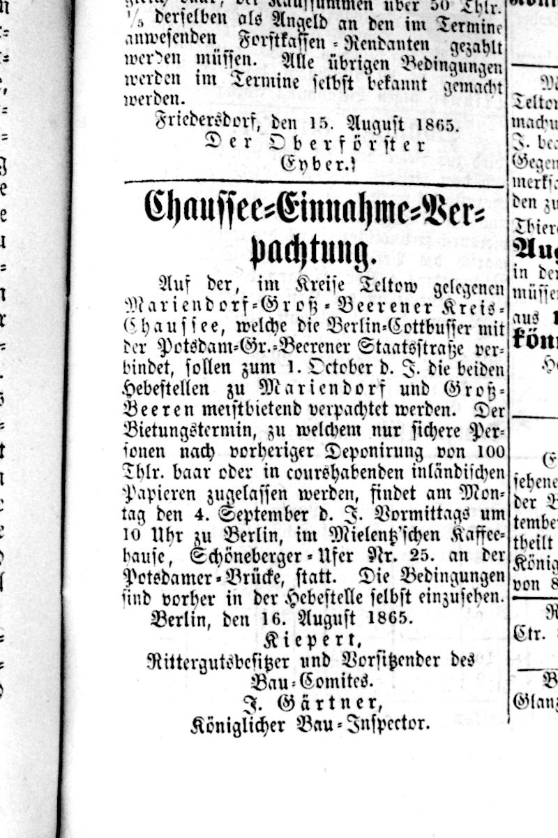
- ↑ Chaussee = Income = Lease 1865 - Working Group Historisches Marienfelde
- ^ Teltower Kreisblatt dated February 7, 1866
- ↑ Topping- out ceremony in the suburbs II and III Marienfelde Timeline - Working Group Historisches Marienfelde
- ↑ Walks through the district ( Memento of the original dated December 31, 2011 in the Internet Archive ) Info: The archive link was inserted automatically and has not yet been checked. Please check the original and archive link according to the instructions and then remove this notice. on www.berlin.de
- ^ Heinz Jung, Wolfgang Kramer: Line chronicle of the Berlin tram 1902–1945. 60th episode . In: Berliner Verkehrsblätter . Volume 5, 1969, pp. 88 .
- ^ Heinz Jung, Wolfgang Kramer: Line chronicle of the Berlin tram 1902–1945. 8th episode . In: Berliner Verkehrsblätter . Issue 8, 1964, pp. 105 .
- ↑ a b Sigurd Hilkenbach, Wolfgang Kramer: The trams in Berlin . 3. Edition. alba, Düsseldorf 1994, ISBN 3-87094-351-3 , p. 79 .
- ^ JGA Ludwig Helling (ed.): History-statistical-topographical pocket book of Berlin and its immediate surroundings. HAW Logier, Berlin 1830. Online at google-ebooks. Retrieved May 20, 2012.
- ↑ Postcard series with historical photos from Dorfstrasse / Alt-Marienfelde Working group Historisches Marienfelde
- ↑ Dorfkern Marienfelde Monument Database Berlin
- ↑ The Savior's Pasture - The legend. The tree. The street. ( Memento of the original from January 18, 2013 in the Internet Archive ) Info: The archive link was inserted automatically and has not yet been checked. Please check the original and archive link according to the instructions and then remove this notice. Private website
- ^ Image of the Heilandsweide 1935 Marienfelde Timeline - Working Group Historisches Marienfelde
- ^ Image of the Heilandsweide 1950 Marienfelde Timeline - Working Group Historisches Marienfelde
- ↑ Belßstrasse and Sunshine Path. Monument database Berlin
- ↑ Beyrodt Horticulture Working Group Historisches Marienfelde
- ↑ Villa Horstenstein Marienfelde Timeline - Working Group Historisches Marienfelde
- ↑ Blohmstrasse . In: Berlin address book , 1943, Tempelhof administrative district> Lichtenrade, p. 1791 (Viktoriastraße).
- ↑ a b c Machine factory Fritz-Werner-Werk Monument database Berlin
- ↑ Memorial plaque for Moritz Jacobsohn on Gedenkenafeln-in-berlin.de
- ↑ On the person of Emilie Kiepert. Kauperts
- ^ Emilie and Adolf Kiepert Working Group Historisches Marienfelde
- ↑ Emilienstraße 15/17 Haus Schippert 1915/1916 Monument database Berlin
- ↑ a b city map from 1907 on www.blocksignal.de
- ↑ Estersstrasse . In: Berlin address book , 1934, Tempelhof administrative district> Mariendorf, Marienfelde, p. 1663.
- ↑ a b "Mariengarten" estate, Berlin monument database
- ^ About the Gebert Kauperts family
- ^ A b Construction site railway underpass Marienfelder Allee 1978 Marienfelde Timeline - Working Group Historisches Marienfelde
- ↑ Holla mountain trail Kauperts
- ↑ The Steglitz trolleybus line A32 on http://www.berliner-verkehrsseiten.de/
- ^ Sheepmaster Ferdinand Lucke 1878 Marienfelde Timeline - Working Group Historisches Marienfelde
- ↑ On the person of Lucke Kauperts
- ↑ Malteserstraße 171a – 171f Monument Database Berlin
- ^ Website of the Historical Lighting Museum
- ↑ The family Sameisky Kauperts
- ↑ Railway crossing at Säntisstraße 1941 Marienfelde timeline - Marienfelde Historical Working Group
- ↑ Säntisstrasse Kauperts
- ↑ Säntisstraße 181 Monument Database Berlin
- ↑ Säntisstraße 183 Monument Database Berlin
- ^ On the person of Schomburg Kaupert
- ↑ On the person of Symeon Kaupert
- ↑ a b On the person of Trachenberg Kaupert
- ↑ Marienfelde on old maps ( Memento of the original from April 13, 2016 in the Internet Archive ) Info: The archive link was inserted automatically and has not yet been checked. Please check the original and archive link according to the instructions and then remove this notice.
- ↑ Marienfelde around 1800, Hans-Werner Fabarius Collection
- ^ Resolution of the Teltow district council on the condition of the roads.
- ↑ Marienfelde Timeline Marienfelde Timeline - Working Group Historisches Marienfelde
- ^ House Möhring Marienfelde Timeline - Working Group Historisches Marienfelde
- ↑ Allotment gardens in the district ( Memento of the original from September 29, 2013 in the Internet Archive ) Info: The archive link was automatically inserted and not yet checked. Please check the original and archive link according to the instructions and then remove this notice. (PDF; 28 kB) Senate for Urban Development Berlin
- ↑ Sister cities of the district ( Memento of the original from December 18, 2014 in the Internet Archive ) Info: The archive link was inserted automatically and has not yet been checked. Please check the original and archive link according to the instructions and then remove this notice. on www.berlin.de
- ↑ Marienfelde Nature Reserve ( Memento of the original from June 15, 2012 in the Internet Archive ) Info: The archive link was inserted automatically and has not yet been checked. Please check the original and archive link according to the instructions and then remove this notice. private website www.berlin-marienfelde.de
- ↑ The royal moat. In: Paul Wollschläger: The Tempelhof District - A Chronicle in Stories and Pictures (PDF; 125 kB). Kulturbuch Verlag, Berlin 1964.
- ↑ Monastery of the Good Shepherd

Adlershof | Altglienicke | Alt-Hohenschönhausen | Alt-Treptow | Baumschulenweg | Biesdorf | Blankenburg | Blankenfelde | Bohnsdorf | Borsigwalde | Britz | Book | Buckow | Charlottenburg | Charlottenburg-North | Dahlem | Falkenberg | Falkenhagener Feld | Fennpfuhl | French Buchholz | Friedenau | Friedrichsfelde | Friedrichshagen | Friedrichshain | Frohnau | Gatow | Gesundbrunnen | Gropiusstadt | Grünau | Grunewald | Hook field | Halensee | Hansaviertel | Haselhorst | Heiligensee | Heinersdorf | Hellersdorf | Hermsdorf | Johannisthal | Karlshorst | Karow | Kaulsdorf | Kladow | Konradshöhe | Köpenick | Kreuzberg | Lankwitz | Lichtenberg | Lichtenrade | Lichterfelde | Lübars | Mahlsdorf | Malchow | Mariendorf | Marienfelde | Märkisches Viertel | Marzahn | Middle | Moabit | Müggelheim | Neu-Hohenschönhausen | Neukölln | Niederschöneweide | Niederschönhausen | Nikolassee | Oberschöneweide | Pankow | Plänterwald | Prenzlauer Berg | Rahnsdorf | Reinickendorf | Rosenthal | Rudow | Rummelsburg | Schmargendorf | Schmöckwitz | Schöneberg | Siemensstadt | Spandau | Staaken | Malchow suburban settlement | Steglitz | Tegel | Tempelhof | Zoo | Adventure | Wannsee | Wartenberg | Wedding | Weissensee | Westend | Wilhelmsruh | Wilhelmstadt | Wilmersdorf | Wittenau | Zehlendorf