
Trebbin
| coat of arms | Germany map | |
|---|---|---|

|
Coordinates: 52 ° 13 ' N , 13 ° 13' E |
|
| Basic data | ||
| State : | Brandenburg | |
| County : | Teltow-Fläming | |
| Height : | 39 m above sea level NHN | |
| Area : | 126.37 km 2 | |
| Residents: | 9639 (Dec. 31, 2019) | |
| Population density : | 76 inhabitants per km 2 | |
| Postal code : | 14959 | |
| Area code : | 033731 | |
| License plate : | TF | |
| Community key : | 12 0 72 426 | |
| LOCODE : | DE TBN | |
| City structure: | 13 districts | |
City administration address : |
Market 1–3 14959 Trebbin |
|
| Website : | ||
| Mayor : | Thomas Berger ( CDU ) | |
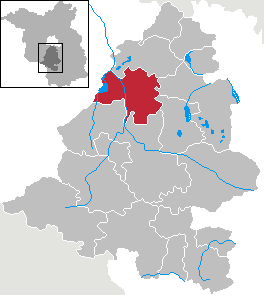
| Location of the city of Trebbin in the Teltow-Fläming district | ||
  |
||

Trebbin is a city in the Teltow-Fläming district in Brandenburg . As the former residence of the Mark Eulenspiegel Hans Clauert , it bears the unofficial nickname Clauertstadt .
geography
Trebbin is located between Teltow and the Fläming on the edge of a lowland east of the Nuthe 36 kilometers south of Berlin . The city is located on the eastern border of the Nuthe-Nieplitz Nature Park or, with some districts, also in the Nature Park. The district of Blankensee is located on the lake of the same name . The district of Glau is located on the Glauer mountains .
City structure
Trebbin consists of the districts
- Blankensee
- Christinendorf
- Glau
- Großbeuthen with the inhabited part of the municipality Kleinbeuthen
- Klein Schulzendorf
- Kliestow
- Löwendorf
- Ludersdorf
- Märkisch Wilmersdorf
- Schönhagen
- Stangenhagen
- Thyrow
- Wiesenhagen
as well as the residential areas: Ebelshof , Eichenhof , Finkenberg, Forsthaus Altlenzburg , Forsthaus Lenzburg , Freie Scholle-Siedlung , Colony Thyrow, Paulshöhe, Plantage, Priedel, Schönblick, Seeblick and Ziegelei.
History and etymology
City name
According to Gerhard Schlimpert, two possible interpretations of the city name Trebbin are possible. The Polish form Trebin could be interpreted as the place of Treba (cf. the Polish personal name Trzeba, derived from Trzebin, or Czech Třeba, derived from Třebin). A Polabian basic form Trebyn- = settlement on the clearing (cf. Lower Sorbian tŕebiś = clean, clear) is also possible. The city itself is based in an information brochure on its West Slavic origins and derives it from trzebienie = clearing.
13th to 16th centuries
Trebbin is an early German rule formation that was carried out either by the Archdiocese of Magdeburg or by a noble family that has not yet been precisely determined. What is certain is that there was a Slavic castle wall in Kliestow , the inhabitants of which gradually oriented themselves more towards the north with the foundation of the castle. Trebbin was first mentioned in a document in 1213. The history of Trebbin begins with Arnoldus de Trebin , who owned Trebbin Castle as a fief in 1213 . On December 28, 1216 the Burgward Trebbin appeared together with other places u. a. with Luckenwalde in a document from the Bishop of Brandenburg. A small domain, the Vogtei Trebbin , from which the Trebbin Office was formed in the late Middle Ages , also belonged to Trebbin Castle . Due to changes that were not documented, the original territory of the Trebbin Bailiwick shrank considerably. The late medieval and early modern office of Trebbin administered next to the city of Trebbin only four places in the vicinity.

In 1315 the city received its independent jurisdiction. Around 1375 Trebbin stood as a margrave municio in the Teltow territory under the administration of the knight Nickel von Beckenburg and was described in the land book of Charles IV as a "very poor oppidum ". In 1412 Trebbin Castle and City appeared. The administration was carried out by a mayor with councilmen who changed annually (around 1500). A market town was created , which developed along the main street. In 1472 the electoral "town" appeared with a parish church and an electoral mill. The city had an important customs office . In (before?) The year 1497 there was a vacant farm with three Hufen and three meadows "near the Mühel", which was owned by the von Thümen . In 1505 it was granted market rights. At that time, the city was surrounded by a fortification with three city gates: the Luckenwalder Tor, the Berliner Tor and the Mühlentor. The city expanded to the west and included a Kietz that had arisen on the east bank of the old Nuthe. There was a plague epidemic around 1534 . More than 300 people fell victim to it. At that time, Trebbin was reduced to rubble by several fires. Thüm's possession was confirmed again in 1543 and passed to the von Treskow family in 1572 . There was another city fire in 1565, in which only the church and a few houses remained. At that time, numerous residents decided to settle in front of the city gates: the Trebbiner Neustadt was created. In 1566 the plague broke out again. In 1571 the freedoms and justice of the citizens of Trebbin were confirmed again. From the year 1573 107 fireplaces (= households) and 38 “stalls” have been handed down. Fire damage was also reported. Before 1586 the jurisdiction in Trebbin came with two hooves in the feudal possession of the von Willicke.
17th century
After the end of the Thirty Years' War in 1648 there were 25 inhabitants in the city, of 149 houses only 24 existed. In 1652 there was a report of the "little town" in which the judge had two feudal hooves. In Trebbin there lived a pastor who was entitled to four parish hooves and one purchased hoof. There was a farmer with four free hooves and one more hoof. The mayor farmed two Hufen; there was also a two-hoofed, six one-hoofed and the Trebbin administrative building with a Vorwerk. There was a hop garden, a water mill, two windmills, a four- acre vineyard behind the farm and a small eyrie called the Boyen. Before 1673 the Schröder family owned the free farm, which in that year passed it on to the von Thiele family. The jurisdiction was sold to the city council by the Willicke (Wilke) family in 1690.
18th century

In 1704 there were 16 citizens (including the mayor) and the Hasenheger in the “little town” . They paid fees to the office from eleven full and two half hooves. An office building was built next to the brewery; there was also an official Vorwerk with a new Meierhaus, stables, bills and a wine master's house. At the gates of the city a sheep farm had been built, in which 600 to 700 sheep were kept at times. The residents also had the right to keep up to 30 head of cattle and up to 20 head of guest cattle, ie female animals that had meanwhile become sterile. Next to the official watermill there were two windmills, one of which belonged to the freed Treskow farm. The official forests also included the “old Clisto” and the “little Horst” as well as the “Boyn” in which individual oaks, elks and hazels grew. In 1719 the building stock in Trebbin had grown to 132 houses, three of which were in desolation . Trebbin became a garrison town in 1722 and remained so until 1918. In 1743, Trebbin became an Immediastadt with a water mill with two gears, a cutting mill and two windmills. Main land tariffs, dam and bridge tariffs were levied at their borders. Outside the city were the royal office, a sheep farm and a wine master's house with a vineyard. In 1745 there were 154 houses in Trebbin, including six parish, school, aristocratic and executioner houses, a mill house and a single house in front of the Berliner Tor. In the official Vorwerk in 1575 a total of 343 acres of fields and 80 acres of meadow and one acre of garden were cultivated. There were ten cows, five young cattle and 200 sheep. In 1758 the free court came to the Fähndrich family, who passed it on to the von Düringshofen family in 1782. From there it came to the Kaßler family in 1791. In 1772 there were 162 houses in the city. In 1797 the foundation stone was laid for the town hall, where the first meeting was held in 1798. This house served the city administration for over 140 years. A hospital, the post office, a school building and a water tower were built.

19th century

In 1801 Trebbin consisted of the city, the official Vorwerk and a colony. There were 189 houses and 52 barns. A water grinding and cutting mill stood in front of the Berliner Tor. There were also two other private windmills. In Trebbin there was a Krammarkt six times a year and a cattle and horse market four times a year. The good was meanwhile grown to five hooves. The field mark of the city with office and property consisted of 1764 acres of 155 square rods and over 1000 acres of common pasture. There were now eight vineyards with a total area of 13 acres and 4348 acres of 112 QR forest, mainly oak, pine and alder . There were also 96 acres of 58 QR urban areas and a fisherman's house in front of the Luckenwalder Tor on the Nuthe. There were 56 farmers, one pharmacist, 15 poor people, eight bakers, a beer teller, three coopers, 33 brandy distillers, 16 brewers, a brewery servant, six woodturners, two iron dealers, two dyers, a fisherman, eight butchers, two innkeepers, a glassmaker a midwife, three shepherds and four farriers and a hatter. The statistics also recorded a “Jewish family”, three merchants, three furriers, a leather merchant, 31 linen weavers, three materialists, four bricklayers, a medical doctor, a water miller, three wind millers, a needler, a night watchman and an oil miller. There was also an orderly man, a belt man, a saddler, a soap boiler, two rope makers, an executioner, 19 shoemakers, eight carpenters and wheel makers, three straw hat makers, 35 day laborers, eleven table makers, two cloth makers, four winemakers, a white tanner and a surgeon and three carpenters. In addition to 58 brewing sites, there were 35 spirits and 51 looms with 82 workers. The officials and officers included seven excisers, a domain official, a postman, two mayors, a cantor, an inspector, a bailiff, a legal advisor, a murderer, a sexton, three magistrates and a mill maker. In addition, an organist, a postmaster, a postilion, three preceptors or schoolteachers, a preacher, a councilor, a servant, three city councilors, a ziesemeister, a customs officer and a customs collector worked for the city. In the Vorwerk there were eight Büdner, a district gardener, seven depositors and a fisherman. There was a sheep farm and three windmills; the district was ten Hufen large and 13 fireplaces (= households) were operated in it. On August 21, 1813, a victorious battle between the French Oudinot corps and the Prussian brigade of August von Thümen took place in Trebbin . In 1819 there were 153 homeowners; In 1822 the official Vorwerk was given to 20 citizens. The connection to the Berlin – Halle railway line took place in 1840. At that time there were already 176 residential buildings in the city and a further 20 residential buildings in the former Vorwerk, now known as the “Colony of Trebbinsche freedom of office”. Around 1850 Trebbin had 1,800 residents. In 1858 there were 27 farm owners in the town who employed 22 servants and maidservants. There were also 15 part-time farmers who employed a further 20 servants and maids. There were 117 workers, 41 servants and one servant. There were 172 properties in the city. The largest holdings comprised 2,475 acres, 31 others were between 30 and 300 acres (together 1836 acres), 53 others were between 5 and 30 acres (together 575 acres), and 87 under five acres (together 261 acres). Numerous trades had settled in Trebbin. Examples are: eight master bakers with seven journeymen and apprentices, five master rope makers with three journeymen and one apprentice or three master glaziers. There was already a master plumber and a musical instrument mechanic. An executioner and a gravedigger also worked in Trebbin; 24 people were rentiers (= pensioners). In the colony there were six part-time farmers as well as 31 workers and three servants. Two properties were between 5 and 30 acres (together 16 acres), four others were under five acres (together 14 acres). In addition to other trades, the colony also had a master bookbinder and a lending library. In 1860 the city consisted of eight dismantles (train station, rifle house, brickworks, four residential houses and the municipal forester's house). There were nine public, 181 residential and 316 farm buildings, including a tobacco factory, two linseed oil factories, a water grain and sawmill, and three grain mills. There were four dismantles in the colony and six dismantles in connection with the city. There were a total of 39 residential and 45 farm buildings, including two flour mills. After 1870, wood, cigar and sand-lime brick factories were built; 1898 a printing company. In 1876 a new reception building was built at the Prussian State Railroad station. In 1881, Trebbin was incorporated into Trebbin. On December 1, 1897, an electricity company began operations; a short time later the waterworks.
20th and 21st centuries

At the turn of the 19th and 20th centuries, gardening and furniture construction developed in Trebbin, the town grew and the population rose from 6594 in 1875 to 7565 in 1910. In the same year, a new school was opened. Two years later the Catholic Church was built. The influx continued unabated.
The first houses in the "Freie Scholle" estate were built in the 1920s by the architect Bruno Taut . The lynx settlement was added in the early 1930s and was incorporated into the municipality in 1941. In 1927 Trebbin existed with the settlement of Freie Scholle and the mining of Bäcke. In 1931 there were 411 houses in the city. A year later there was the city with the residential areas Chausseehaus and the Freie Scholle settlement. In the same decade Trebbin became known as a center of German gliding . This is how an imperial gliding school was established in today's Schönhagen district. The Aviation Engineering School (IfL) was temporarily housed on their premises in 1939 . In February 1939 the foundation stone was laid for today's town hall . In the same year, 9,069 people lived in the city. After the end of the Second World War , the number of residents grew to over 11,000, also due to the influx of displaced people. 14 hectares of agricultural land were expropriated and distributed among nine farmers who received between one and five hectares of land.
In 1956 a type III LPG was founded with 19 members and 148 hectares of agricultural land. The GPG Flower City was founded in 1960 with 14 members and an area of 2.4 hectares, which gave Trebbin the nickname Flower City for a while . Their number rose to 163 members with 26 hectares at the end of 1960. There was also the VEG horticulture with 13 employees and the LPG type III with 46 members and 200 hectares. On March 1, 1962, a railway accident occurred on the Anhalter Bahn near Kliestow in which more than 70 people were killed. In 1971 the LPG merged with the LPG in Kliestow to form the LPG Kliestow-Trebbin, based in Kliestow. In 1973 there was the VEB Feuerlöschgerätewerk Luckenwalde with the Trebbin branch, the VEB IFA-Automobilwerke Ludwigsfelde with the Trebbin branch, the VEB Malzbierbrauerei, the VEB Möbelkombinat Hellerau, Märkische Möbelwerke Trebbin, the VEB Oberlausitzer Volltuchfabrik Görlitz, Stützpunkt VEB Vereinigte Holzindustrie Potsdam-Süd with the Trebbin plant and the Trebbin Forest District. There was also the PGH roofing trade and the already mentioned GPG flower city.
Löwendorf has been part of the urban area since May 1, 1976. In the following decades the population steadily decreased and only stabilized at around 8,000 inhabitants in the early 1990s. Since then, the number of inhabitants has risen steadily, also due to the incorporation, and is now around 9300 inhabitants.
On June 15, 1992 Blankensee, Christinendorf, Glau, Großbeuthen, Kleinschulzendorf, Kliestow, Lüdersdorf, Märkisch Wilmersdorf, Schönhagen, Stangenhagen, Thyrow, Wiesenhagen and the city of Trebbin merged to form the new Trebbin Office . In 1995 the city council decided to renovate the city center . The focus was on the redesign of the market square, which was characterized by high traffic. An architectural office from Verona , Italy , was awarded the contract to redesign the square, which included a fountain with a figure by Hans Clauert . From September 27, 1998 the Trebbin Office used the administration of the city of Trebbin to fulfill its tasks.
On December 31, 1997, the communities of Glau, Kliestow, Wiesenhagen and the city of Trebbin merged to form the new city of Trebbin. On September 27, 1998, the town of Trebbin was joined by the communities of Stangenhagen, Blankensee and Klein Schulzendorf. In 2000 the council expanded the urban redevelopment to include the area up to the Berliner Tor. It thus comprised 171 buildings, of which a total of 73 structures could be renovated by 2006. Up to this point in time, around 5.7 million euros in public funds had been used. For example, the corner house at Berliner Strasse 43, but also the buildings at Puschkinstrasse 9, Beelitzer Strasse 8 and 50, were renovated in accordance with listed buildings. On October 26, 2003, the municipalities of Lüdersdorf, Schönhagen and Thyrow were finally incorporated into the city of Trebbin by law, the Trebbin office was dissolved and the city of Trebbin became vacant. In 2004, the municipality of Thyrow lodged a municipal constitutional complaint against its legally mandated incorporation into the city of Trebbin before the Brandenburg Constitutional Court, but this was rejected.
The incorporations in the overview:
| Former parish | date | annotation |
|---|---|---|
| Blankensee | September 27, 1998 | |
| Christinendorf | December 31, 1997 | Incorporation after Thyrow |
| Glau | December 31, 1997 | |
| Großbeuthen | December 31, 1997 | Incorporation after Thyrow |
| Kleinbeuthen | July 1, 1950 | Incorporation to Großbeuthen |
| Klein Schulzendorf | September 27, 1998 | |
| Kliestow | December 31, 1997 | |
| Löwendorf | May 1, 1976 | |
| Ludersdorf | October 26, 2003 | |
| Märkisch Wilmersdorf | December 31, 1997 | Incorporation after Thyrow |
| Schönhagen | October 26, 2003 | |
| Stangenhagen | September 27, 1998 | |
| Thyrow | October 26, 2003 | |
| Wiesenhagen | December 31, 1997 |
In 2013, the city celebrated its 800th anniversary for a week with a historical parade and a festival program. With 574 participants, the largest open-air tournament in the checkers game to date took place, which led to an entry in the Guinness Book of Records .

- Meteorite impact on March 1st, 1988
On March 1, 1988, members of the horticultural production cooperative, Blumenstadt Trebbin, heard a hissing noise. A short time later, they heard a sound that sounded like glass shattering. They suspected damage to one of their greenhouses , but could not find any change. It wasn't until the next day that they discovered a shattered disc and some rocks. They handed the fragments over to a mineralogist who in turn informed the district council in Potsdam . The pieces were brought to the GDR Academy of Sciences , which collected a total of 16 fragments. They have a total weight of 1.25 kg. The largest piece weighs around 300 grams. The scientists identified the fragments as chondrites . The impact is one of the 46 detected meteorites found in Germany to date (as of 2014). On the occasion of the 5th German Meteorite Colloquium in Trebbin, the mayor and participants of the colloquium unveiled an information board on Bahnhofstrasse in Trebbin.
History of the districts
Glau was first mentioned in 1368 as Gloych . The word means head and is to be understood as a metaphor for mountain . From 1920 to 1935 Joseph Weißenberg had the Christian settlement of Friedensstadt built with forty buildings that offered space for around 500 people. The settlement was the largest and most modern private settlement in Germany at the time. In 1938 the SS took over the site and after the Second World War the Red Army took over . In 1994 the Johannische Kirche got the site back.
Märkisch Wilmersdorf was called Wendisch Wilmersdorf until October 20, 1937, Wiesenhagen was Neuendorf until January 8, 1938.
Population development
|
|
|
|
|
Territory of the respective year Population: As of December 31 (from 1991), from 2011 based on the 2011 census
politics
City Council
The city council of Trebbin consists of 18 city councilors and the full-time mayor. Since the local elections on May 26, 2019 , it has been composed as follows:
| Party / group | Voices 2014 | Voices 2019 | Seats 2014 | Seats 2019 | |
|---|---|---|---|---|---|
| CDU | 29.3% | 23.3% | 5 | 4th | |
| Voting group fresh wind | - | 16.7% | - | 3 | |
| AfD | 7.0% | 13.6% | 1 | 2 | |
| Independent Free Voters | 14.3% | 11.7% | 3 | 2 | |
| New list | 13.6% | 9.3% | 3 | 2 | |
| SPD | 13.0% | 9.0% | 2 | 2 | |
| Alliance 90 / The Greens | 4.3% | 8.0% | 1 | 1 | |
| THE LEFT | 8.0% | 5.3% | 1 | 1 | |
| THE PARTY | - | 3.2% | - | 1 | |
| Individual applicant Hendrik Bartl | 10.5% | - | 1 | - |
mayor
- since 1998: Thomas Berger (CDU)
In the mayoral election on September 14, 2014, Berger was elected with 82.8% of the valid votes for a further term of eight years (voter turnout 49.4%).
coat of arms
The coat of arms was approved on January 7, 1999.
Blazon : "Under a silver shield head in three rows of four places of black and silver."
In public presentations, the coat of arms is regularly represented by an exposed red wall crown.
Town twinning
Sights and culture
In the list of architectural monuments in Trebbin and in the list of ground monuments in Trebbin are the cultural monuments entered in the monuments list of the state of Brandenburg.


Buildings
- The Protestant Church of St. Mary was built between 1740 and 1744 as an extension of a building from the 13th century. At the behest of Friedrich II, its architecture and furnishings were based on the garrison church in Potsdam in 1740 .
- The St. Anne's Chapel was built in the 14th and 15th centuries. Century next to the Annenhospital as a hospital chapel. The late Gothic building with a three-aisled floor plan and a choir is dedicated to Saint Anne and is used as a winter church in the 21st century .
- Residential houses Luckenwalder Strasse 4 and Beelitzer Strasse 47
- Memorial to the victims of the concentration camps on the corner of Berliner Strasse and Bahnhofstrasse
- Christinendorf village church with rectory
- The village church of Stangenhagen is a hall church from 1727 with a patronage of the von Thümen . In addition to a wooden pulpit altar , the church furnishings include three paintings from the end of the 16th and 17th centuries. Century showing scenes from the New Testament .
- The village church Thyrow is a Romanesque stone church from the 13th century. The multi rebuilt tower dates from 1794. The interior contains a Baroque gallery and an Dinse - organ from the year 1908th
- The Eichberg House is a listed building in the Thyrow district, which was probably built in 1923. The chess player Emanuel Lasker lived in the house , later the film producer and namesake Richard Eichberg
- Weissenberg, a city of peace in the Glau district
- NaturPark Center at the Glauer Tal game reserve with an adventure exhibition, nature tours, herb kate and a game reserve in the Nuthe-Nieplitz nature park.
- Blankensee mansion with castle garden
- The Märkisch Wilmersdorf manor house is a one-storey plastered building from 1801, which was expanded in 1901 to a two-and-a-half-storey building in Tudor style . The building was renovated after 2000. The original facade design was restored.
- Landhaus Villa Schönblick and Schönhagen Airport
- The European long-distance hiking trail E 10 leads to the observation tower on the Löwendorfer Berg . Other regional hiking trails lead through the city and districts, including the 66 lakes hiking trail .
Clauert circular route
The Clauert circular route connects a total of twelve places in the city that are connected to Clauert's life. They lead, for example, to Clauert sculptures made of wood and bronze , but also lead the viewer to listed buildings such as St. Anne's Chapel or to other historically interesting points such as Fischerstraße, which is considered the oldest street in the city.
Regular events
- Trebbin takes part in the 48 hours Nuthe-Nieplitz campaign , during which visitors can go on a journey of discovery through the nature park with the help of public transport . The train station in Trebbin is the start and end point of the tour.
- Music event Pop meets Classic
- Blankensee music summer
- Concert series in the village church in Blankensee
- Open courtyards in the Nuthe-Nieplitz Nature Park in the districts of Blankensee and Wiesenhagen
- Series of events culture in Kliestow
- Special exhibitions in the Farmer's Museum in Blankensee and in the Trebbin home parlor
Economy and Infrastructure
Established businesses
Vattenfall Europe operates a gas turbine power station in Thyrow with a 380 kV transformer station and traction current converter station.
Since the fall of the Wall in the GDR , the economic focus has tended to be on agriculture. For example, around twenty agricultural companies in the region have come together to form a marketing company called Offene Höfe . They open their operations on one day each in May and November to give those interested a look behind the scenes. There are also a number of companies in vehicle construction, gardening and printing companies, and companies in aviation technology. Numerous traders are organized in the Trebbin eV trade association . A training initiative was launched on their initiative, but the Trebbin Card is also an idea of the association. The aim is to keep purchasing power in the region through discounts and other promotions.
Medical care is provided by a medical care center in Trebbin and a health center in Glau.
traffic

Bundesstrasse 101 runs east of the city center of Trebbin between Berlin and Luckenwalde . The Trebbin bypass was released in 2006. It is crossed by the federal highway 246 Beelitz - Zossen . The closest motorway junction is Ludwigsfelde-Ost on the A 10 (southern Berliner Ring).
The station Trebbin is located at the Berlin-Halle railway . The regional express of the RE 3 Stralsund - / Schwedt - Berlin - Falkenberg (Elster) / - Lutherstadt Wittenberg runs there . The Thyrow district has a stop along the same route .
The largest airfield in Brandenburg is located in Trebbin-Schönhagen .
education
- There are five day-care centers and four kindergartens in the city. There are also three after-school care centers and four youth clubs.
- Primary school in Trebbin and Blankensee
- Goethe High School in Trebbin
- Hans Clauert City Library
- Clauerthaus with a stage and an event hall
societies
Around 50 clubs are active in the city. In 1882 the Trebbin Volunteer Fire Brigade was founded. It is the third oldest fire brigade in the Teltow-Fläming district and consists of a total of four fire engines . The Sportclub Trebbin eV (SC Trebbin) has existed in Trebbin since December 2nd, 1992, consisting of the departments handball, athletics and fitness / dance groups.
Personalities

sons and daughters of the town
- Wilhelm Hensel (1794–1861), painter and draftsman, married to Fanny Mendelssohn Bartholdy
- Gustav Schulze (1880–1968), racing cyclist
- Hugo Schottmüller (1897–1936), bacteriologist
- Hans-Dietrich Disselhoff (1899–1975), ethnologist
- Robert Keller (1901–1972), resistance fighter against National Socialism
- Gerhard Kneifel (1927–1992), composer, arranger and orchestra leader
Personalities associated with Trebbin
- Hans Clauert (around 1506–1566), Brandenburg "Eulenspiegel"
- Bartholomäus Krüger (around 1540 – after 1597), town clerk and organist in Trebbin
- Karl Friedrich Ebel, a merchant in Trebbin, captured a war chest of the Napoleonic troops during the wars of liberation and after his death bequeathed his fortune of 36,000 marks to the city, which was supposed to support those in need with these financial means. The money was used to build the Henriettenstift and the Ebelstiftung, among other things.
- Fritz Graf von Schwerin (1856–1934), dendrologist , writer and manor owner (lived in Märkisch Wilmersdorf)
literature
- Friedrich Wilhelm August Bratring : Statistical-topographical description of the entire Mark Brandenburg . Volume 2: Containing the Mittelmark and Ukermark . Berlin 1805, pp. 345-348 .
- Manfred Bensing u. A. / Heinz Göschel (Hrsg.): Lexicon cities and coats of arms of the German Democratic Republic , VEB Bibliographisches Institut Leipzig 1985, 3rd ed.
- Lutz Heydick, Günther Hoppe, Jürgen John (eds.): Historical guide. Sites and monuments of history in the districts of Potsdam, Frankfurt (Oder) , Urania-Verlag, Leipzig Jena Berlin 1987, 1st edition, ISBN 3-332-00089-6 .
- Thomas Berger - Mayor of the City of Trebbin (Ed.): City of Trebbin and its districts , brochure of the City of Trebbin 2004.
- Lieselott Enders : Historical local lexicon for Brandenburg: Teltow (= Historical local lexicon for Brandenburg . Volume 4). Verlag Hermann Böhlaus successor, Weimar 1976.
Web links
- Official website of the city
- Schönhagen in the RBB program Landschleicher on October 9, 2005
Individual evidence
- ↑ Population in the State of Brandenburg according to municipalities, offices and municipalities not subject to official registration on December 31, 2019 (XLSX file; 223 KB) (updated official population figures) ( help on this ).
- ↑ Main statute of the city of Trebbin from February 18, 2009 ( Memento from December 15, 2015 in the Internet Archive ) (PDF; 44 kB)
- ^ Service portal of the state government - City of Trebbin
- ↑ a b Gerhard Schlimpert : Brandenburg name book part 3 The place names of the Teltow. 368 p., Hermann Böhlaus successor, Weimar 1972.
- ↑ a b City of Trebbin (ed.): The Red Carpet in Trebbin - An information brochure on urban redevelopment , August 2006, p. 20.
- ↑ a b Heimatverein Trebbin (ed.): History of Trebbin Castle , leaflet, no date, p. 8
- ↑ a b The source for the population of the city is the historical municipality directory of the Office for Statistics Berlin-Brandenburg, 2005 PDF
- ^ Formation of the Trebbin Office. Announcement of the Minister of the Interior of May 13, 1992. Official Gazette for Brandenburg - Joint Ministerial Gazette for the State of Brandenburg, Volume 3, Number 38, June 15, 1992, p. 744.
- ^ Amendment of the agreement for the formation of the Trebbin Office. Announcement of the Ministry of the Interior of July 14, 1998. Official Gazette for Brandenburg - Joint Ministerial Gazette for the State of Brandenburg, Volume 9, Number 32, August 14, 1998, p. 714.
- ↑ Merger of the communities of Glau, Kliestow, Wiesenhagen and the city of Trebbin (Trebbin Office) to form a new city of Trebbin. Announcement of the Ministry of the Interior of December 23, 1997. Official Journal for Brandenburg Common Ministerial Gazette for the State of Brandenburg, Volume 9, Number 2, January 17, 1998, p. 26.
- ^ Formation of a new community from the communities of Stangenhagen, Blankensee, Klein Schulzendorf, and the city of Trebbin. Announcement of the Ministry of the Interior of May 18, 1998. Official Gazette for Brandenburg - Joint Ministerial Gazette for the State of Brandenburg, Volume 9, Number 22, June 11, 1998, p. 506.
- ↑ Fourth law on the state-wide municipal area reform concerning the districts Havelland, Potsdam-Mittelmark, Teltow-Fläming (4th GemGebRefGBbg) of March 24, 2003
- ↑ Municipal constitutional complaint procedure of the Thyrow municipality because of the incorporation into the city of Trebbin VfGBbg 204/03 Decision of November 18, 2004 S-No. 1338
- ↑ a b City of Trebbin (ed.): "Clauertstadt Trebbin", Trebbin 2014, p. 40.
- ^ The Trebbin Meteor , website of the city of Trebbin, accessed on July 13, 2014.
- ↑ Statistics of the German Reich, Volume 450: Official municipality directory for the German Reich, Part I, Berlin 1939; Page 249
- ↑ Historical municipality register of the state of Brandenburg 1875 to 2005. District Teltow-Fläming . Pp. 26-29
- ↑ Population in the state of Brandenburg from 1991 to 2017 according to independent cities, districts and municipalities , Table 7
- ^ Office for Statistics Berlin-Brandenburg (Ed.): Statistical report AI 7, A II 3, A III 3. Population development and population status in the state of Brandenburg (respective editions of the month of December)
- ^ Result of the local elections on May 25, 2014
- ^ Result of the local election on May 26, 2019
- ↑ Results of the local elections in 1998 (mayoral elections) for the Teltow-Fläming district ( Memento from April 9, 2018 in the Internet Archive )
- ↑ Brandenburg Local Election Act, Section 74
- ^ Result of the mayoral election on September 14, 2014
- ↑ Coat of arms information on the service portal of the state administration of Brandenburg
- ↑ Bypass at Trebbin released . In: Berliner Morgenpost , November 14, 2006
- ^ City of Trebbin (ed.) Clauerstadt Trebbin , 2014, p. 40
Blankensee | Christinendorf | Glau | Großbeuthen with Kleinbeuthen | Klein Schulzendorf | Kliestow | Löwendorf | Lüdersdorf | Märkisch Wilmersdorf | Schönhagen | Stangenhagen | Thyrow | Wiesenhagen