
Nuthe
| Nuthe | ||
 Course of the Nuthe river |
||
| Data | ||
| Water code | EN : 584 | |
| location | Brandenburg , Germany | |
| River system | Elbe | |
| Drain over | Havel → Elbe → North Sea | |
| source | At Dennewitz in Fläming 51 ° 58 ′ 27 ″ N , 12 ° 59 ′ 44 ″ E |
|
| Source height | 81 m above sea level NN | |
| muzzle | In Potsdam in the Havel coordinates: 52 ° 23 '44 " N , 13 ° 4' 14" E 52 ° 23 '44 " N , 13 ° 4' 14" E |
|
| Mouth height | 29.4 m above sea level NN | |
| Height difference | 51.6 m | |
| Bottom slope | 0.78 ‰ | |
| length | 66.5 km | |
| Catchment area | 1935 km² | |
| Discharge at the Babelsberg A Eo gauge : 1787 km². Location: 1.2 km above the mouth |
NNQ (05/29/1989) MNQ 1955–1999 MQ 1955–1999 Mq 1955–1999 MHQ 1955–1999 HHQ (03/28/1970) |
150 l / s 2.13 m³ / s 8.75 m³ / s 4.9 l / (s km²) 22.5 m³ / s 35.6 m³ / s |
| Left tributaries | Nieplitz | |
| Right tributaries | Hammer flow | |
| Big cities | Potsdam | |
| Medium-sized cities | Luckenwalde | |
| Small towns | Jueterbog , Trebbin | |
The Nuthe is a left tributary of the Havel . For the last few meters it is a Brandenburg state waterway .
Surname
The name "Nuthe" could be of Germanic origin and mean something like "ditch, gutter" or "valley". In Middle High German means Nuot "Fugue" or "groove". Other interpretations derive the name from the old German Nuth = Noth , as the many huge floods that are hardly comprehensible today brought with them great "distress". An old name for the upper reaches of Jüterbog and Luckenwalde is Aa or Aarbach . In 1814 the upper course of the Nuthe was still referred to as the A , Ahe , Agerbach .
River course
Its source is located in Fläming in the state of Brandenburg in the municipality of Niedergörsdorf , west of the Dennewitz district . Tributaries are the Nieplitz near Gröben and the Hammerfließ near Woltersdorf . At Nuthetal there is a branch of the Nuthe - the horse mackerel. In a northerly direction the Nuthe flows through the larger towns of Jüterbog , Luckenwalde , Trebbin and the municipality of Nuthetal. After about 66.5 km of flow and after the Nuthe has overcome an altitude difference of around 51 m, it opens at 29.4 m above sea level. NN in Potsdam in the Havel. It flows through the Glogau-Baruther glacial valley and further north, smaller glacial valleys . In its lower reaches it is built like a canal and diked . Its catchment area covers 1,935 km². A large part of its course leads the Nuthe through the Nuthe-Nieplitz Nature Park . The moist green meadows, former floodplains and the smaller Elsbrüche of the nature park offer the white stork and the heron ideal conditions; especially the heron population has been increasing continuously since the 1990s.
history
Theodor Fontane scoffed at the Nuthe and the even smaller sister Nieplitz ; compared to these rivers, the Havel looked as if the Volga were passing by. Nevertheless, in contrast to the Nieplitz (presumably from Slavic: unsavailable ) in the region of the confluence of the Nuthe and Nieplitz near Gröben , the "old Nuthe" was still up to 40 m wide around 1880 and before its various regulations (1776 to 1786, 1883) partly navigable. Before the regulations, the river was known for the "Nuthekrebse", which were delivered as a delicacy to Leipzig and Paris . In a story from the 1820s, the introduction to Fontane's rendering reads:
“It was the time when, like every year, the raft wood, bolted together into three or four trunks, came down the Nuthe in a long, long line, first in the Havel near Potsdam and then in the Elbe near Havelberg . And, as usual, all sorts of crews had been commanded on board this time too, who, with oars and poles in hand, had to prevent the raft from moving up and down by constantly pushing off the bank. There were eleven of them, all of them young fellows from Trebbin and Thyrow, ... "
The Nutheburgen , already shrouded in secrecy for Fontane, could have existed as early as 1150, at the time of Albrecht the Bear , according to him. See Saarmund in more detail . The remains of one of these castles can still be found near the city of Trebbin. This is an earth wall, surrounded by the obligatory moat, there was a Slavic castle, well documented in drawings and excavations by the history teacher of the Goethe High School Trebbin, Mr. Zumke. The school owns or was also found objects from this period, such as the remains of old knives, swords and axes.
environment
At its upper reaches in Fläming it has the character of a so-called salmonid water . According to the Ministry of Rural Development, Environment and Agriculture of the State of Brandenburg, Nuthe is in poor chemical condition caused by tributyltin (TBT).
The Nuthe is of great ecological importance for fish (second from the top priority level out of a total of four), as it is one of the rivers, which are indispensable as so-called connecting waters for interregional biotope networks and the connection of the spawning habitats of long-distance migrants and potamodromic species. Therefore, essential measures for the creation and improvement of the longitudinal and lateral continuity as well as the water structure have been introduced, whereby a new construction of transverse structures, retention basins, dams or hydropower plants has to be excluded.
Flood catastrophes continued into the 18th and 19th centuries: in
1755. In that year there was no hay to be mowed because of the excessive amount of water, and for this reason both harvests turned out badly. (From the Gröben church book, reproduced by Fontane.)
Trivia
The former Drewitz motorway triangle west of Berlin was renamed the Nuthetal triangle ( A 10 and A 115 ).
Pictures of the Nuthe

Reference to the source

source

Nuthestromtal

Nuthe in Luckenwalde

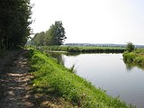
Between Jütchendorf and Gröben
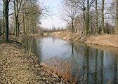
The confluence of the Nieplitz near Gröben

At Saarmund , looking north with the junction of the Mühlgraben
The Nuthe near Potsdam
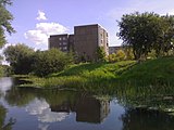
In the area of the Potsdamer Schlaatz

In Potsdam, on the lower left edge of the picture, the dam to the Aradosee

It flows into the Havel, opposite the Friendship Island in Potsdam
_Nuthequelle.jpg)


See also
literature
- Water hiking atlas of the GDR . VEB Landkartenverlag Berlin, 2nd edition, 1975
- A, Ahe, Agerbach . In: August Schumann : Complete State, Post and Newspaper Lexicon of Saxony. 1st volume. Schumann, Zwickau 1814, p. 3.
- Christa and Johannes Jankowiak: On the way to Nuthe and Nieplitz . Stapp Verlag, Berlin 1995, ISBN 3-87776-061-9
Web links
- TMB Tourismus Marketing Brandenburg GmbH
- State Institute for Large Protected Areas Brandenburg
- Nature watch in Brandenburg
- Renaturation project "Old Nuthe - New Life"
Individual evidence
- ↑ rivers directory gewnet25 (Version 4.0, April 24, 2014). Ministry for Rural Development, Environment and Agriculture of the State of Brandenburg; accessed on May 4, 2015.
- ^ German Hydrological Yearbook Elbe Region, Part II 1999 Brandenburg State Environment Agency, p. 144, accessed on November 3, 2018, at: lugv.brandenburg.de (PDF, German).
- ^ Theodor Fontane : Groben now. In: Walks through the Mark Brandenburg . Volume 4 ( Spreeland ) “Gröben and Siethen”.
- ↑ Implementation of the European Water Framework Directive. (PDF) Contributions from the State of Brandenburg to the management plans and programs of measures for the Elbe and Oder river basin districts. State Office for Environment, Health and Consumer Protection. Potsdam, September 2011. (accessed May 17, 2015)