Nuthetal motorway triangle
| Nuthetal motorway triangle | |
|---|---|
|
|
|
| map | |
| location | |
| Country: | Germany |
| State : | Brandenburg |
| Coordinates: | 52 ° 18 ′ 1 ″ N , 13 ° 5 ′ 1 ″ E |
| Height: | 55 m above sea level NN |
| Basic data | |
| Design type: | Complete triangle (Full-Y) |
| Bridges: | 3 (motorway) / 2 (other) |
| Construction year: | 1940 |
| Last modification: | 2006-2009 |
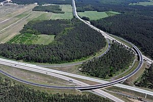
| Aerial photo of the finished AD Nuthetal in May 2011 | |

The Nuthetal motorway triangle (abbreviation: AD Nuthetal ; short form: Nuthetal triangle ) is a motorway triangle in Brandenburg in the Berlin metropolitan region . It connects the federal highway 115 ( AVUS ) to the federal highway 10 (Berliner Ring) .
geography
The triangle lies on the municipal areas of Michendorf and Nuthetal in the Potsdam-Mittelmark district . The closest districts are Saarmund , Wildenbruch and Langerwisch . It is located about 30 kilometers southwest of downtown Berlin , about ten kilometers south of Potsdam and about 120 kilometers northeast of Leipzig .
The current name of the triangle, which lies in the municipality of Michendorf , was given by the neighboring municipality of Nuthetal , through which the Nuthe flows. To the west of the triangle stood the hourly oak , known to motorists until 2004 , which indicated that one was an hour away from the center of Berlin.
It is not far from the Nuthe-Nieplitz and Dahme-Heideseen nature parks .
It is an important hub for traffic from southern and western Germany to Berlin, for example it connects the routes from Munich ( A 9 ), Hanover and the Rhine-Ruhr metropolitan region ( A 2 ) with the Berlin city ring .
The Nuthetal motorway triangle has junction number 16 on the A 10 and number 9 on the A 115.
history
The autobahn triangle was created in 1941 under the name Saarmunder Dreieck as a right-hand trumpet . The structure should connect the motorway coming from the AVUS to the Berliner Ring. At the time of the division of Germany , the triangle was called the Drewitz branch after today's Potsdam district of Drewitz . The old name is particularly familiar to many West Berliners , as the central transit route to West Berlin branched off in Drewitz . During the GDR times, some modifications were made to the triangle. The north-west and west-north ramps were rebuilt with less tight curves. The design of the triangle had disadvantages, especially for the north-east connection, as the narrow indirect ramp with a radius of only 100 meters could only be driven on at low speed.
After German reunification , traffic density increased sharply. For 2015, it was forecast that there will be an average of 120,000 vehicles a day on the section of the A 10 to the west of the motorway triangle, more than on any other section of the Brandenburg road. Between 2006 and July 2009, the triangle was the last to be fundamentally modernized on the southern Berliner Ring. The narrow ramps north-east and west-north were replaced by direct ramps , similar to the Spreeau triangle , which enabled higher speeds. The redesign was part of Project 11 of the German Unity Transport Projects . The cost was around 35 million euros .
Design and state of development
The A 115 has six lanes, as is the A 10 in the direction of Schönefelder Kreuz . The A 10 to the Potsdam triangle has seven lanes, with four lanes to the east. The connecting ramps for the Berlin - Hanover route and vice versa have three lanes, the ramps for the Berlin - Ludwigsfelde route have two lanes .
The triangle was laid out as a complete triangle in Y-shape .
Traffic volume
The triangle is used by around 106,000 vehicles every day.
| From | To | Average daily traffic volume |
Share of heavy goods traffic |
||||
|---|---|---|---|---|---|---|---|
| 2005 | 2010 | 2015 | 2005 | 2010 | 2015 | ||
| AS Ludwigsfelde-West (A 10) | AD Nuthetal | 55,700 | 52,500 | 54,700 | 21.4% | 25.7% | 26.9% |
| AD Nuthetal | AS Michendorf (A 10) | 89,500 | 89,200 | 100,500 | 18.0% | 22.6% | 19.0% |
| AS Saarmund | AD Nuthetal (A 115) | 59,600 | 54,800 | 56,600 | 7.5% | 7.6% | 6.5% |
Web links
Individual evidence
- ↑ Dreieck Nuthetal is completely released. Berliner Morgenpost , July 8, 2009, accessed on February 28, 2013 .
- ↑ Manual road traffic census 2005. (PDF) Results on federal motorways. BASt Statistics, 2005, accessed on January 15, 2019 .
- ↑ Manual road traffic census 2010. (PDF) Results on federal motorways. BASt Statistics, 2010, accessed on January 15, 2019 .
- ↑ Manual road traffic census 2015. (PDF) Results on federal motorways. BASt Statistics, 2015, accessed on January 15, 2019 .


