Hirzer (Sarntal Alps)
| Hirzer | ||
|---|---|---|
|
The Hirzer massif from the west: on the left in the background the main peak, in the middle the Obere Scharte, on the right in the background the Hönig |
||
| height | 2781 m slm | |
| location | South Tyrol , Italy | |
| Mountains | Sarntal Alps | |
| Dominance | 10.4 km → Kolbenspitze ( Ötztal Alps ) | |
| Notch height | 687 m ↓ Jaufenpass | |
| Coordinates | 46 ° 44 '13 " N , 11 ° 16' 35" E | |
|
|
||
| particularities | highest peak in the Sarntal Alps | |
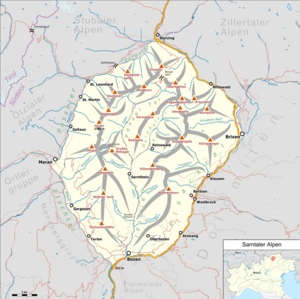
The Hirzer ( Italian Punta Cervina ) is with a height of 2781 m slm the highest mountain in the Sarntal Alps in South Tyrol ( Italy ).
Location and surroundings
The Hirzer is located roughly in the middle of the western ridge of the Sarntal Alps, which at this point separates Passeier in the west and the Sarntal in the east. From its main peak, four ridges lead in different directions. The ridge, which extends to the north, falls over an intermediate peak to the Grünangerjoch ( 2433 m ), which separates the Hirzer from the Pfandlspitze ( 2539 m ). While the north-west ridge runs down towards Passeier without any further elevations, the one leading to the south-east to the Sarntal valley still has a prominent pre-peak in the Leiterspitze ( 2339 m ). The summit structure of the Hirzer sinks south to the Obere Scharte ( 2679 m ), from where the ridge extends without significant differences in height to the Hönig ( 2696 m ) (also Hönigspitz ).
Administratively, the Hirzer belongs to the South Tyrolean communities Schenna and Sarntal .
Alpinism
The Hirzer, not far from Merano , is the highest peak in the Sarntal Alps and an important and easily accessible tour destination. The area is accessible from Passeier by the Hirzer cable car , the mountain station of which is near the Hirzerhütte . This is where the normal route to the Hirzer begins, which - part of the European long-distance hiking trail E5 - leads through the southwest flank of the mountain to the Obere Scharte and from there through the south side of the summit structure to the top. A somewhat longer route first climbs the Hönig over its west ridge and then follows the ridge to the Obere Scharte and continues on the normal route to the summit. Another marked trail comes up from the Sarntal side from the southeast and only joins the normal route just below the summit.
Surname
The mountain name probably goes back to the Middle High German word hirz with the meaning "deer". It probably refers to deer populations in the forests at the foot of the mountain. Historically, there was also the alternative name Prenner Spitze , which referred to the hamlet of Prenn in the municipality of Schenna and was used, for example, in the Atlas Tyrolensis .
Web links
- hoehenrausch.de (accessed September 24, 2015)
- Brochure Hofeisentour (accessed September 24, 2015)
Individual evidence
- ↑ Johannes Ortner: Disagreement and other errors . In: Experience the mountains - The magazine of the Alpine Association of South Tyrol . No. 5 , 2019, p. 60-61 .


