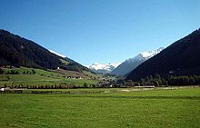
Sarntal

The Sarntal ( Italian Val Sarentino ) is a 45 km long valley in South Tyrol ( Italy ). The Talfer flows through it in a north-south direction . The northern end of the Sarntal is at the Penser Joch ( 2211 m ), in the south it rises in the Bozen valley basin ( 260 m ), where the Eisack valley meets the Adige valley . It is completely enclosed by the Sarntal Alps .
Administratively, the Sarntal belongs largely to the same municipality Sarntal . In the south, in the area of the Sarner Gorge , it is distributed among the municipalities of Renon , Jenesien and Bozen .
course
The Sarntal begins at the Penser Joch at an altitude of 2211 m . In its northern half it describes a slight curve to the west between the Sarner Westkamm and Mittelkamm. In this section, also known as the Penser Valley , the villages of Pens , Weißenbach and Aberstückl are located from north to south .
At Astfeld , the Durnholzer Tal , which is added from the northeast, flows into the Sarntal. Somewhat down the Talfer are Nordheim and the municipality capital Sarnthein, the most important village settlements.
South of Bundschen , the Sarntal narrows between the Ritten and the Tschögglberg to form the Sarner Gorge , which forms the lowest section of the valley. The Sarntal finally rises in the Bozen valley basin at a height of around 260 m .
geology
The different character of the Sarntal in its course - dominated by gentle terrain in the north and clearly widened, in the south narrowed to a gorge - can be explained by the geological conditions. North of Bundschen, rapidly weathering quartz phyllites dominate , which favored the formation of a wide valley; If there are slopes there, this is due to the occasional occurrence of rock types that are more resistant to weathering . In the south, on the other hand, the hard Bozen quartz porphyry plates of the Tschögglberg in the west and the Renon in the east, between which the Talfer had to dig a deep gorge.
traffic
There are two main entrances into the Sarntal for road traffic : the southern feeder leads from the Bozen valley basin through the Sarner gorge . As early as 1494 , a “common farweg und strazzen in the valley Sérnntein an der Etsch” was commissioned by King Maximilian I and carried out by the Sarnthein bailiff Blasius Anich. This often relocated road was replaced in 1936 between Schloss Ried and Moarhäusl with an orographically right-hand tunnel road (SS 508), which was laid out in a high rock position because of a reservoir project that was not implemented. Thanks to a number of major projects, the Sarntal State Road was led more and more through tunnels and the remaining endangered sections were secured by rock protection work. As a result, locks have become rarer today. The last re-routing, in which two tunnels with a total length of around 3.5 km replaced fifteen smaller and narrow tunnels, was opened to traffic in December 2016. Since around 1,400 inhabitants of the municipality commute to Bolzano every day, this route is of great importance.
The northern access to traffic is made from Sterzing via the Penser Joch . However, this pass is closed in winter, usually four to five months.
A third driveway runs over the Renon . Due to its narrow, winding and steep sections, this road is closed to buses (except for public buses when the state road is closed) and trucks and, coming down from Oberinn and Wangen , flows north of the Sarner Gorge into the state road coming from Bolzano. Nevertheless, this approach has often proven its importance, as in the past it was the only still passable access to the valley as soon as the state road was closed due to falling rocks and the Penser Joch was still closed in winter.
Castles in the lower Sarntal
The Sarner Gorge and the transition to the Bozen valley basin are known for their high density of medieval castles . On the eastern orographic left side is the first system at the Klebenstein valley entrance , followed by Rendelstein , Runkelstein , Wangen-Bellermont and the Johanneskofel . Ried , Rafenstein , Walbenstein and Afing are located one after the other on the opposite side of the Talfer .
literature
- Leo Andergassen : Sarntaler church art . Lana 1996, ISBN 88-7073-214-2 .
- Luis Oberkalmsteiner: Stories from the Sarntal. Ferrari-Auer, Bozen 1968, without ISBN.
- Josef Rampold : Bozen: center of the country on the Adige and in the mountains. The town and hikes in the areas of Salten, Sarntal, Renon, Eggental (= South Tyrolean regional studies . Volume 7). 4th edition. Athesia, Bozen 1985, ISBN 88-7014-050-4 .
- Anselm Sparber : Settling the Sarntal . In: Der Schlern 7, 1920, pp. 199–203 (online) .
- Helmut Stampfer (Ed.): Farms in South Tyrol. Volume 2: Sarntal . Athesia, Bozen 1993, ISBN 88-7014-702-9 .
- Oswald Trapp (Ed.): Tiroler Burgenbuch. V. Volume: Sarntal . Publishing house Athesia, Bozen 1981, ISBN 88-7014-036-9 .
Web links
Individual evidence
- ^ Peter Ortner , Christoph Mayr: Südtiroler Naturführer . Athesia, Bozen 1977, pp. 101-108
- ^ Hannes Obermair : Bozen Süd - Bolzano Nord. Written form and documentary tradition of the city of Bozen up to 1500 , Volume 2, Bozen: Stadtgemeinde Bozen 2008, ISBN 978-88-901870-1-8 , p. 218f No. 1291.
- ↑ Karl Theodor Hoeniger : Altbozner picture book , 3rd edition, Bolzano 1968, p.276..
- ^ Sarntaler Straße: Second tunnel pierced ( memento from February 17, 2016 in the Internet Archive ), accessed on February 17, 2016.
Coordinates: 46 ° 39 ′ 44 ″ N , 11 ° 21 ′ 51 ″ E

