
List of streets and squares in Berlin-Alt-Hohenschönhausen

This list of streets and places in Berlin-Alt-Hohenschönhausen describes the existing streets and places of the district Alt-Hohenschönhausen listed in the Berlin street directory . At the same time, this compilation is part of the lists of all Berlin streets and places .
overview
Statistical
Alt-Hohenschönhausen has 48,979 inhabitants (as of December 30, 2019). The street network of the district is centrally aligned with the village center on the main road, with the main roads leading to it essentially corresponding to the historical connections. In addition, there are three connections in the south with Landsberger Allee , in the west with Weißenseer Weg and Indira-Gandhi-Straße and in the north-west with Hansastraße, which touch the district and partly also form its border. In the east, however, the district is delimited from the Berlin outer ring .
A total of 154 streets and four squares run completely or partially on the Alt-Hohenschönhauser area. The longest connection is Landsberger Allee as the southern boundary of the district with around 2800 meters and Konrad-Wolf-Straße , which runs exclusively in the district, with 2400 meters. The shortest streets are Elfriedestraße in the northern villa district with around 60 meters and Markfriedstraße in the garden city with a length of about 75 meters.
Naming principles
The streets can usually be assigned to a specific district based on their name and the time they were named. Designations that differ from this generally apply to the historical connections to the surrounding districts and the central streets within the district. In relation to the current street names, the following phases can be determined chronologically:
- The streets in the older, southern part of the villa district north of Konrad-Wolf-Straße were given the names of politicians from the Niederbarnim district before and around 1900 .
- Shortly after it was built, 1900 women's names for the streets gave the younger (northern) part of the villa district its name.
- In the Märkisches Viertel , also laid out around 1900, the streets are named after places in the eastern Mark Brandenburg .
- In 1920 and later, as a reaction to the Greater Berlin Act, various streets were renamed after politicians from the previously independent rural community of Berlin-Hohenschönhausen.
- In 1925 the streets of the garden city were named after male first names.
- In 1927 the streets north of Landsberger Allee in the White Taube and Dingelstädter Straße settlements were given names from Thuringian towns. Two more streets followed in 1936. Some of the streets were de-designated in the 1970s, but in the 1990s they were rebuilt along their historic lines.
- In 1930 and 1936, the streets west of Malchower Weg were named after places in Neumark .
- Also in 1936, the streets north of Feldtmannstrasse were named after places in the Eifel . To the east and southwest of Malchower Weg , a small private settlement was built, the streets of which are still listed as numbered private streets.
- Between 1976 and 1980 the streets newly laid out in the new development areas of Hohenschönhausen I north of Landsberger Allee and Hohenschönhausen II in the vicinity of Hauptstraße were given the names of places in Barnim .
In addition, there are other individual cases as well as various streets that are still referred to as numbered streets - for example street 142 . The historical names are listed with the respective streets.
Overview of streets and squares
The following table gives an overview of the streets and squares in the district as well as some related information.
- Name / location : current name of the street or square. Via the link Location , the street or the square can be displayed on various map services. The geoposition indicates the approximate center of the street length.
- Traffic routes not listed in the official street directory are marked with * .
- Former or no longer valid street names are in italics . A separate list may be available for important former streets or historical street names.
-
Length / dimensions in meters:
The length information contained in the overview are rounded overview values that were determined in Google Earth using the local scale. They are used for comparison purposes and, if official values are known, are exchanged and marked separately.
For squares, the dimensions are given in the form a × b for rectangular systems and for (approximately) triangular systems as a × b × c with a as the longest side.
If the street continues into neighboring districts, the addition ' in the district ' indicates how long the street section within the district of this article is. - Name origin : origin or reference of the name.
- Notes : further information on adjacent monuments or institutions, the history of the street and historical names.
- Image : Photo of the street or an adjacent object.
| Name / location |
Length / dimensions (in meters) |
Origin of name | Date of designation | Remarks | image |
|---|---|---|---|---|---|
|
Allendorfer way
( Location ) |
400 | Allendorf, part of the town of Bad Sooden-Allendorf in Hesse | Sep 30 1927 | Allendorfer Weg leads from Ferdinand-Schultze-Straße to Dingelstädter Straße. The road is interrupted twice by Rhinstrasse and an allotment garden. Previously the street was referred to as Straße 111 . |

|
| Altenhofer Strasse
( Location ) |
800 | Altenhof , part of the community Schorfheide in Brandenburg | Oct 27, 1976 | Altenhofer Straße was laid out north of Landsberger Allee during the construction of the new development area and runs from Sandinostraße in an arc to Konrad-Wolf-Straße . |

|
| At the Lazy Lake
( Location ) |
875 | Fauler See , body of water in the Weissensee district | Aug 4, 1930 | The road runs parallel to the eastern boundary of the nature reserve at Faulen See and leads from Suermondtstrasse to Drossener Strasse. |

|
| Anna-Ebermann-Strasse
( Location ) |
425 | Anna Ebermann (1891–1944), resistance fighter | Feb. 4, 1976 | Anna-Ebermann-Straße runs from Wartenberger Straße to Gehrenseestraße with several branches and was built as part of the new development area Hohenschönhausen II. |

|
| Anna-Maria-Müller-Strasse | Anna-Maria Müller , luge athlete, Olympic champion and multiple European and GDR champion | 2014 | The street is located in the Olympia district of the Gartenstadt residential park a little parallel to Anna-Ebermann-Straße. Here the 'Deutsche Serienhaus AG' in Berlin-Alt-Hohenschönhausen is building twelve single-storey terraced houses on an area of around 30,000 m² and further individual residential villas have been or are still being built (September 2017). |
.JPG)
|
|
| Annemariestrasse
( Location ) |
190 | Annemarie , female first name | before 1913 | Annemariestraße is located in the northern part of the villa district and leads from Oberseestraße to Suermondtstraße. |

|
| Arendsweg
( Location ) |
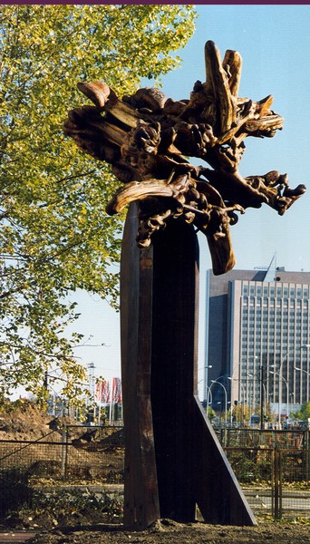
715 | Leopold Arends (1871–1882), inventor of a shorthand | Sep 30 1927 | The Arendsweg leads from Lichtenauer Straße to Landsberger Allee and forms the north-south axis of the White Taube settlement. It was previously known as Straße 101 , and for a long time the connection had the unofficial name Taubenweg . This originally led to Ferdinand-Schultze-Strasse. In a small green area on the corner of Landsberger Allee, the root sculpture made by Wolfgang Stübner in 1995 stands head over heels . |

|
| Arnimstrasse
( Location ) |
680 | Arnim , male first name | Jan. 16, 1925 | Arnimstrasse runs from Wartenberger Strasse to Gehrenseestrasse and forms the northern boundary of the garden city. Between 1953 and 1983, the turning loop of tram line 63 was at the eastern end. Before that, it was known as Straße 45a . |

|
| Augustastrasse
( Location ) |
235 | Augusta , female name | before 1907 | Augustastraße is located in the northern part of the villa district and leads from Oberseestraße to Elsastraße. Originally the beginning of the street was on Orankestrasse, this part was added to Oberseestrasse in the 1920s. |

|
|
Bahnhofstrasse
( Location ) |
460 | Freight station in Berlin-Hohenschönhausen | 1912 | The street runs parallel to the Tegel – Friedrichsfelde industrial railway and represents the connection from Konrad-Wolf-Straße to the Hohenschönhausen freight station. |

|
| Bennostrasse
( Location ) |
435 | Benno , male first name | Jan. 16, 1925 | Coming from Gehrenseestraße to Detlevstraße, the street forms the southern end of the garden city of Hohenschönhausen. Previously it was known as Street 54a . |

|
| Berkenbrücker Steig
( Location ) |
250 | Berkenbrück , municipality in Brandenburg | 1947 | The Berkenbrücker Steig runs from Konrad-Wolf-Straße to Mittelstraße. The connection was previously known as Birkenstraße and between 1937 and 1947 as Kurt-Ecker-Straße .
In the 21st century, the Swedish construction and real estate company NCC had 30 townhouses built along this street with a small garden around them. This residential complex was named Stadtoase Wilhelmsberg . |

|
| Bertastrasse
( Location ) |
125 | Berta , female name | before 1915 | Bertastraße leads west from Augustastraße and ends as a dead end in front of the Orankestrand. |

|
| Biesenthaler Strasse
( Location ) |
260 | Biesenthal , city in Brandenburg | Oct 27, 1976 | Biesenthaler Straße was laid out during the construction of a new housing estate north of Landsberger Allee and runs at right angles from Joachimsthaler Straße to Arendsweg. |

|
| Biesterfelder Strasse
( Location ) |
325 | Biesterfelde, since 1945 Bystrze, a town in the Miłoradz municipality in the Pomeranian Voivodeship, Poland | May 17, 1930 | Biesterfelder Strasse leads north from Niehofer Strasse to Malchower Weg, where it turns into Strasse 142. It was previously known as Street 20 . |

|
| Bitburger Strasse
( Location ) |
835 (in the district) |
Bitburg , city in Rhineland-Palatinate | July 10, 1933 | Bitburger Straße leads from Piesporter Straße to Kyllburger Weg, and a footpath leads to Hansastraße. Between Piesporter Strasse and Perler Strasse is the street in Weißensee, where the street is also interrupted by a body of water. Previously, the road was a road D respectively. |

|
| Bürknersfelder Strasse
( Location ) |
540 | Bürknersfelde , former Vorwerk in Marzahn | Nov. 30, 1995 | Bürknersfelder Strasse runs west from Wassergrundstrasse and ends at the route of the former Tegel – Friedrichsfelde industrial railway. |

|
|
Chamierstrasse
( Location ) |
105 | Heinrich Wilhelm Artur von Chamier (1833–1906), head of office in Hohenschönhausen | before 1912 | Chamierstrasse is located in the southwestern part of the villa district and forms a connection between Orankestrasse and Manetstrasse. |

|
| Christianstrasse
( Location ) |
410 | Christian , male first name | Jan. 16, 1925 | The street is located in the northern part of the garden city and runs from Arnimstraße to Elsengraben. It was previously known as Straße 42 . |

|
| Christophstrasse
( Location ) |
95 | Christoph , male first name | Jan. 16, 1925 | The street is located in the northern part of the garden city and runs along Elsengraben when coming from Lotharstraße. Previously it was called Street 41a . |

|
|
Darßer Strasse
( Location ) |
120 (in the district) |
Darß , central part of the Fischland-Darß-Zingst peninsula in Mecklenburg-Western Pomerania | Jan. 18, 1990 | Darßer Straße originally only ran as far as Ribnitzer Straße and was extended in 1992 over the Darßer Bridge to Roelckestraße in Weißensee. Only the short section from the Falkenberger Chaussee junction to behind the Kyllburger Weg is in the district. The longer section belongs to the Malchow suburb . The southern section was previously called Hohenschönhauser Weg . |

|
| Dasburger way
( Location ) |
85 | Dasburg , local parish in Rhineland-Palatinate | Oct. 30, 1936 | Dasburger Weg leads in an arc from Kyllburger Weg to the west and ends a few meters afterwards as a dead end. An allotment garden and another road that has been added to the Waxweiler Weg will follow. Previously it was known as Street 225 . |

|
| Degnerstrasse
( Location ) |
1275 | Friedrich Degner (1855–1907), entrepreneur | 1912 | The road begins in the southwest at Konrad-Wolf-Strasse , crosses Suermondtstrasse and ends in the northeast at Malchower Weg. The namesake Friedrich Degner was the head and technical manager of the operator of the Berlin – Hohenschönhausen tram , whose depot was located at 9 Degnerstraße. Previously it was called Bahnhofstrasse after the tram station located there . |

|
| Detlevstrasse
( Location ) |
470 | Detlev , male first name | Jan. 16, 1925 | Detlevstraße runs from Gehrenseestraße under the Gehrenseebrücke to Bennostraße and forms the eastern boundary of the garden city. It was previously known as Straße 45 . |

|
| Dietrichstrasse
( Location ) |
315 | Dietrich , male first name | Jan. 16, 1925 | Dietrichstrasse runs in the northern part of Gartenstadt parallel to Gehrenseestrasse from Arnimstrasse in the direction of Edgarstrasse. The original end of the building was the former Dietrichplatz at the intersection of the two streets, which was partially built over in the 1980s. Previously it was known as Straße 43 . |

|
| Dingelstädter Strasse
( Location ) |
575 | Dingelstädt , city in Thuringia | Sep 30 1927 | Dingelstädter Straße is the central north-south axis of the settlement of the same name , which was built in the 1920s. Originally going from Landsberger Allee to Plauener Straße, the road became a dead end after the latter was moved. At number 48a there is a memorial plaque for Artur Becker , who lived here from 1929 to 1933. Previously it was known as Street 114 . |

|
|
Döhrendahlstrasse
( Location ) |
100 | Friedrich Wilhelm Döhrendahl (1892-1918), winner of the Golden Military Merit Cross , in the First World War fallen | Aug 25, 1939 | Döhrendahlstraße runs in an arch from Seefelder Straße to Malchower Weg and then turns into Titastraße. As part of the formerly private small settlement on Malchower Weg, it was previously referred to as Privatstrasse 15 . |

|
| Drossener Strasse
( Location ) |
570 | Drossen , town in the Lubusz Voivodeship, Poland , when mooring in the Neumark | May 17, 1930 | Drossener Straße runs from Malchower Weg to the Fauler See nature reserve. Previously, she was a street A designated. |

|
|
Edgarstrasse
( Location ) |
335 | Edgar , male first name | Jan. 16, 1925 | Edgarstrasse in the northern part of the garden city leads from Lotharstrasse to Gehrenseestrasse and then merges into Norbertstrasse. It was previously known as Straße 44 . |

|
| Elfriedestrasse
( Location ) |
60 | Elfriede , female first name | before 1912 | Elfriedestraße in the northern part of the villa district leads from Oberseestraße to Elsastraße. |

|
| Elsastrasse
( Location ) |
555 | Elsa , female name | before 1907 | Elsastraße runs from Suermondtstraße parallel to Oberseestraße to Sabinensteig. |

|
| Erich-Hagen-Strasse | Erich Hagen , cyclist , Olympic participant and multiple GDR champion | 2014 | The street is in the Olympic quarter of the Gartenstadt residential park. Here, the 'German Terraced House AG' in Berlin-Alt-Hohenschönhausen is building twelve single-storey terraced houses on an area of around 30,000 m² and further individual residential villas. |
.JPG)
|
|
|
Falkenberger Chaussee
( Location ) |
100 (in the district) |
Falkenberg , part of the Lichtenberg district of Berlin | Beginning 19th century | The Falkenberger Chaussee is part of the historical connection between Berlin and Bad Freienwalde (Oder) . At the beginning of the 19th century the street was expanded into a Chaussee. It is used by the tram. Only a short distance between Darßer Straße / Malchower Weg and the district boundary to Neu-Hohenschönhausen lies in the district. |

|
| Feldtmannstrasse
( Location ) |
755 (in the district) |
Heinrich Feldtmann (1838–1905), community leader of Weißensee | before 1900 | Feldtmannstraße runs from Berliner Allee to Hansastraße and is not continuously passable at the level of Kyllburger Weg. The street in Berlin-Weißensee is located between Berliner Allee and Perler Strasse . |

|
|
Ferdinand-Schultze-Strasse
( Location ) |
1500 | Ferdinand Schultze (1858–1934), community representative in Hohenschönhausen | 1920 | Ferdinand-Schultze-Straße originally ran directly from the eastern end of the main street to Landsberger Allee, in the 1920s the northern end was moved to Gärtnerstraße and the old branch was kept as a footpath. |

|
| Freienwalder Strasse
( Location ) |
555 | Bad Freienwalde (Oder) , city in Brandenburg | before 1906 | Freienwalder Strasse in the Märkisches Viertel runs from Konrad-Wolf-Strasse to Genslerstrasse. At the eastern end is the entrance to the former MfS remand prison and today's Berlin-Hohenschönhausen Memorial . Until 1990, the section north of Goeckestrasse was a restricted area due to its proximity to the prison. |

|
| Friedhofstrasse
( Location ) |
130 | to the cemeteries in Hohenschönhausen | before 1902 | Friedhofstraße leads from Orankestraße to the western end of Roedernstraße. |

|
| Fritz-Lesch-Strasse
( Location ) |
1015 | Fritz Lesch (1898–1937), resistance fighter | March 27, 1973 | Fritz-Lesch-Straße runs from Weißenseer Weg to Orankeweg and forms the northern access road to the Hohenschönhausen Sportforum . Various competition venues, institutions and the Werner-Seelenbinder-Oberschule are located on it. The former street 118 was renamed on the occasion of the 20th anniversary of the founding of SV Dynamo . |

|
|
Gartnerstrasse
( Location ) |
690 | original location behind the gardens of the main street | before 1905 | Gärtnerstraße runs from Konrad-Wolf-Straße to Rhinstraße in the south parallel to the main street. In the 1990s, the street was expanded in order to prepare a possible redesign of the main street into a pedestrian zone. In the first years of their facility, the traffic route was called Gartenstrasse . In this street is the Hohenschönhausen Municipal Cemetery, where a DenkOrt was inaugurated on October 24, 1998 , commemorating the victims of the Soviet special camp No. 3. The DenkOrt consists of the field of graves covered with field stones, a memorial stone with an inscription and a cast-iron plaque, the entrance designed with thorn bushes and a labyrinth made of oak planks. |

|
|
Gehrenseestrasse
( Location ) |
1180 (in the district) |
Gehrensee , waters in the district of Falkenberg | Jan. 11, 1980 | Gehrenseestrasse runs in the district from Wartenberger Strasse to the Berlin outer ring and continues to Falkenberg . It divides the garden city into a southern and northern part. Between 1953 and 1983 tram number 63 ran on the street. Until 1980 it was called Falkenberger Straße. |

|
| Gembitzer Strasse
( Location ) |
430 | when creating the street Gembitz (→ Gębice ), a village in the municipality of Pępowo in the Greater Poland Voivodeship, Poland | May 17, 1930 | Gembitzer Straße runs from Malchower Weg to Niehofer Straße. Along the street there are partly new buildings of the new development area Hohenschönhausen II. It was previously known as street 19 . |

|
| Genslerstrasse
( Location ) |
1015 | Albert Gensler (1866–1944), community representative in Hohenschönhausen | 1920 | Genslerstrasse runs from Bahnhofstrasse to Landsberger Allee . The section between Bahnhofstrasse and Lössauer Strasse was a restricted area until 1990 due to its proximity to the MfS remand prison . A side branch from Genslerstrasse to Zechliner Strasse largely corresponds to the former Eichsfelder Strasse , which was de-dedicated in the 1970s.
The remand prison, opened in May 1945, served as special camp No. 3 for the Soviet secret service NKVD until October 1946 . The entire area then came to the MfS, which controlled the citizens here (house numbers 13 / 13a) using wiretapping and surveillance systems. Opponents of the regime were arrested in the other buildings. After the fall of the Wall , the entire area was transformed into a memorial . At the corner of Landsberger Allee and Genslerstraße, the Allee-Center shopping center has been located since 1994 with around 50 specialist shops. |

|
| Gerhard-Schulz-Strasse | Gerhard Schulz (rider) , Olympian and GDR champion | 2014 | The street is located in the Olympic quarter of the Gartenstadt residential park and, together with Harry-Glaß-Strasse and Helga-Haase-Strasse, forms a triangular area. Here, the 'German Terraced House AG' in Berlin-Alt-Hohenschönhausen is building twelve single-storey terraced houses on an area of around 30,000 m² and further individual residential villas. |
.JPG)
|
|
| Gertrudstrasse
( Location ) |
220 | Gertrud , female first name | before 1907 | The Gertrudstraße leads from the Oberseestraße to the Orankestrand and ends there as a dead end. The entrance to the Orankesee lido is on the road . |

|
| Gerzlower Strasse
( Location ) |
200 | Gerzlow (→ Jarosławsko ), a village in the Pełczyce municipality in the West Pomeranian Voivodeship, Poland | Nov 9, 1936 | Gerzlower Straße leads from Am Faulen See street to Degnerstraße. It was previously referred to as Street 126 . |

|
| Goeckestrasse
( Location ) |
840 | Feodor Goecke (1836–1907), employee of the land acquisition and construction company in Berlin | before 1915 | Goeckestrasse runs parallel to Große-Leege-Strasse from Freienwalder Strasse to Simon-Bolivar-Strasse. On the section between Strausberger Strasse and Simon-Bolivar-Strasse is the Hippopotamus settlement north of the road . |

|
| Gottfriedstrasse
( Location ) |
590 | Gottfried , male first name | Jan. 16, 1925 | Gottfriedstrasse in the northern part of the garden city runs from Wartenberger Strasse to Gehrenseestrasse and, after Gehrenseestrasse, forms the most important connection within this settlement. It was previously referred to as Street 39 . |

|
| Grenzgrabenstrasse ( location ) |
405 | Marzahn-Hohenschönhauser Grenzgraben | Nov. 30, 1995 | Grenzgrabenstraße runs from Marzahner Straße to Bürknersfelder Straße in a north-south direction and is located on the site of the Hohenschönhauser industrial park west of the Berlin Northeast freight station. |

|
| Gropiusstrasse
( Location ) |
125 | Manon Gropius (1855–1933), owner of the Hohenschönhausen manor | 1878 | The street named after the mother of the architect Walter Gropius runs in the southern part of the villa district from Roedernstraße to Orankestraße. |

|
|
Große-Leege-Strasse
( Location ) |
1755 | Julius Grosse-Leege , owner of the Hohenschönhausen manor , co-founder of the land acquisition and construction company in Berlin | before 1912 | The street runs from Sandinostrasse in the southwest to Konrad-Wolf-Strasse in the northeast. The namesake Julius Grosse-Leege was the head of the land acquisition and construction company in Berlin, which began in 1893 with the parceling of the areas around Upper and Orankesee . In 1912 the former Steindamm and the subsequent Lichtenberger Steig were renamed Große-Leege-Straße.
In the early 1970s, a restricted area was created in this street, which was established and used by the State Security of the GDR. A characteristic feature was an eight-storey prefabricated building (house numbers 101 to 103) roughly measuring 120 m × 30 m, which was used as the headquarters of the management of the rear services administration (VRD), later also for the personnel department and as a canteen. After reunification, it became the town hall of the Hohenschönhausen district until 2001 . Since the merger with the Lichtenberg district, the renovated house has now been used for a number of social projects (including the Lichtenberg family office, daycare center, midwifery school, sports club) and as a cultural meeting point (lower picture). Five stumbling blocks along this street also point to earlier history. |

|
|
Hansastrasse
( Location ) |
880 (in the district) |
Hanse , medieval association of merchants | June 1, 1988 | Hansastraße (formerly Falkenberger Straße) runs in the district in two sections. The short western part is between Indira-Gandhi-Straße and Orankeweg. It was rebuilt in 1988 on previously undeveloped land. The longer section from the district border to Pankow (district Weißensee ) to Darßer Straße / Malchower Weg was part of the B 158 , the historical connection between Berlin and Bad Freienwalde (Oder) , until the 1990s . Tram line M 4 runs on this section of the road. |

|
| Harry Glass Street | Harry Glaß , ski jumper, Olympic participant and multiple GDR champion | 2014 | The street is in the Olympic quarter of the Gartenstadt residential park. Here, the 'German Terraced House AG' in Berlin-Alt-Hohenschönhausen is building twelve single-storey terraced houses on an area of around 30,000 m² and further individual residential villas. |
.JPG)
|
|
|
Main road
( Location ) |
730 | according to the meaning | around 1902 | The main street is the oldest street in the district and the central axis of the village center. It runs in a west-east direction between Suermondt- / Konrad-Wolf-Straße and Wartenberger / Rhinstraße . Since 1899 a tram line has been connecting Hauptstrasse with downtown Berlin. Previously the street was called Dorfstraße . |

|
| Heckelberger Ring
( Location ) |
505 | Heckelberg, part of the municipality of Heckelberg-Brunow in Brandenburg | Aug 13, 1980 | The Heckelberger Ring goes in an arch from the Gärtnerstraße and ends there too. It was created in the course of the construction of the new development area south of the main road. |

|
| Hedwigstrasse
( Location ) |
215 | Hedwig , female name | before 1912 | Hedwigstrasse originally ran along the ITF route from Degnerstrasse to Suermondtstrasse. When new apartments were being built along the street, the south branch was abandoned and the street was merged with Idastraße, which leads north to Degnerstraße. |

|
| Heiligenstadter Strasse
( Location ) |
95 | Heilbad Heiligenstadt , city in Thuringia | Sep 30 1927 | Heiligenstadter Strasse leads from Genslerstrasse to Liebenwalder Strasse. In its original course, the street continued to the former Suhler Straße. In the 1970s, the east branch was then dismantled and largely built over. It was previously referred to as Street 108 . |

|
| Heldburger Strasse
( Location ) |
380 | Heldburg , city in Thuringia | March 20, 1998 | Heldburger Straße branches off from Arendsweg and runs in an east-west direction parallel to Landsberger Allee . It will function as an access road after the expansion of the White Dove settlement. Since construction has not yet taken place, the road is closed to motor vehicle traffic. The street originally existed before 1930 and was de-dedicated in the 1970s to give way to a new building area. At that time it ran from the former Hornberger Strasse to Ferdinand-Schultze-Strasse. |

|
| Helga-Haase-Strasse | Helga Haase , speed skater, Olympic champion | 2014 | The street is in the Olympic quarter of the Gartenstadt residential park. Here, the 'German Terraced House AG' in Berlin-Alt-Hohenschönhausen is building twelve single-storey terraced houses on an area of around 30,000 m² and further individual residential villas. |
.JPG) |
|
| Hertastrasse
( Location ) |
110 | Herta , female name | before 1910 | Hertastraße leads from Oberseestraße to Elsastraße and is located in the northern part of the villa district. |

|
| Hofheimer Strasse
( Location ) |
75 | Hofheim in Lower Franconia , town in Bavaria | Feb 14, 1997 | Hofheimer Strasse branches off from Sollstedter Strasse in a northerly direction. In the further course the road should lead south to Landsberger Allee, this area has so far remained undeveloped. The street originally existed before 1930, but was de-devised in the 1970s to provide space for a new development area. |

|
| Hohengraper way
( Location ) |
295 | Hohengrape (→ Chrapowo ), a village in the Pełczyce municipality in the West Pomeranian Voivodeship, Poland | Nov 9, 1936 | The Hohengraper Weg leads south of Gerzlower Strasse to Tamseler Strasse. The extension led as Sternberger Straße , further to Neuzeller Weg and is only a footpath. The path was previously called Straße 127 . |

|
|
Indira Gandhi Street
( Location ) |
880 (in the district) |
Indira Gandhi (1917–1984), Indian politician | Aug 11, 1985 | Indira-Gandhi-Straße was part of the connection between Weißensee and Lichtenberg as Lichtenberger Weg , since the 1870s as Lichtenberger Straße . In 1985 the street was renamed after the recently murdered Indian Prime Minister. The road and the subsequent Weißenseer Weg form the western boundary of the district. It runs in the district between Orankeweg and the southeast side of the Jewish cemetery . On the east side of the traffic route are the monument ensembles of the former Kindl brewery from 1929 and the BVG bus station from 1959 to 1966, the Hohenschönhausen sports forum with an unused swimming pool and - right on the corner with Konrad-Wolf-Straße - the now vacant Sporthotel Berlin . |
 
|
|
Joachimsthaler Strasse
( Location ) |
385 | Joachimsthal , city in Brandenburg | Oct 27, 1976 | Joachimsthaler Straße was laid out as part of the new development area Hohenschönhausen I and runs in a semicircle south of Plauener Straße. |

|
| Joachim-Böhmer-Strasse | Joachim Böhmer , rower , successful Olympian and multiple GDR champion | 2014 | The street is in the Olympic quarter of the Gartenstadt residential park. Here, the 'German Terraced House AG' in Berlin-Alt-Hohenschönhausen is building twelve single-storey terraced houses on an area of around 30,000 m² and further individual residential villas. |
.JPG)
|
|
|
Josef-Höhn-Strasse
( Location ) |
540 | Josef Höhn (1902–1945), resistance fighter | Feb. 4, 1976 | Josef-Höhn-Straße is located in the Hohenschönhausen II development area between Wartenberger Straße and Gehrenseestraße. It runs largely along the Elsengraben, which forms the south-western boundary of the garden city. |

|
| Jutta-Langenau-Strasse | Jutta Langenau , internationally successful swimmer and multiple GDR champion in the 1950s | 2014 | The street is in the Olympic quarter of the Gartenstadt residential park. Here, the 'German Terraced House AG' in Berlin-Alt-Hohenschönhausen is building twelve single-storey terraced houses on an area of around 30,000 m² and further individual residential villas. |
.JPG)
|
|
|
Kätheplatz
( Location ) |
40 × 35 | Käthe , female first name | before 1915 | Kätheplatz is located at the east end of the Obersee on Käthestrasse. The square is directly connected to the adjoining Oberseepark and forms a unit with it. |

|
|
Käthestrasse
( Location ) |
245 | Käthe , female first name | before 1907 | The Käthestraße in the northern part of the villa district runs in a semicircle from the Oberseestraße back to the Oberseestraße. |

|
| Klarastrasse
( Location ) |
110 | Klara , female name | before 1907 | Klarastrasse leads from Oberseestrasse via Elsastrasse to Suermondtstrasse. The originally straight course was abandoned when a block of flats was built. |

|
|
Königswalder Strasse
( Location ) |
510 | Königswalde (→ Lubniewice ), city in the Lubusz Voivodeship, Poland | May 17, 1930 | The Königswalder Straße leads from Malchower Weg towards the nature reserve Fauler See. It was originally a road B , respectively. |

|
|
Konrad-Wolf-Strasse
( Location ) |
2400 | Konrad Wolf (1925–1982), film director | Oct. 20, 1985 | Konrad-Wolf-Strasse is the main thoroughfare between downtown Berlin and Hohenschönhauser Hauptstrasse. It runs from Weißenseer Weg in a south-west-north-east direction to Suermondt- / Hauptstraße. The street has been used by a tram since 1899. The name was changed on the occasion of the 60th birthday of Konrad Wolf, who had died three years earlier. It was previously called Berliner Strasse or Hohenschönhauser Strasse .
There are numerous architectural monuments of factories and houses on this street. |

|
|
Küllstedter Strasse
( Location ) |
240 | Küllstedt , municipality in Thuringia | Feb 14, 1997 | Küllstedter Straße is located in the residential area Weisse Taube and leads in a north-south direction from Plauener Straße to Landsberger Allee. The section south of Sollstedter Straße is undeveloped and the lane is closed to motor vehicle traffic. |

|
|
Küstriner Strasse
( Location ) |
980 | Küstrin (→ Kostrzyn nad Odrą), town in the Lubusz Voivodeship, Poland | before 1907 | The Küstriner Straße leads from the Freienwalder Straße to the Sandinostraße and runs parallel between the Konrad-Wolf- and the Große-Leege-Straße. In the middle of the street, the section between Strausberger and Reichenberger Straße is closed to motor vehicle traffic due to a Soviet memorial. |

|
| Kyllburger Weg
( Location ) |
415 | Kyllburg , town in Rhineland-Palatinate | Oct. 30, 1936 | The Kyllburger Weg runs north of Hansastrasse between Feldtmannstrasse and Darßer Strasse. Previously it was known as Street 223 . |

|
|
Landsberger Allee
( Location ) |
2780 (in the district) |
Altlandsberg , city in Brandenburg | Jan. 31, 1992 | With a length of around eleven kilometers, Landsberger Allee is one of the longest streets in Berlin. The original Berliner Chaussee was renamed Landsberger Chaussee around 1923 , and it was partially incorporated into Leninallee, named after the Soviet revolutionary leader Lenin , which was renamed Landsberger Allee in 1992. Between Weißenseer Weg and the Berlin outer ring, the street forms the southern boundary to the districts of Fennpfuhl and Lichtenberg in the Lichtenberg district and to the Marzahn district in the Marzahn-Hellersdorf district . |

|
| Leuenberger Strasse
( Location ) |
470 | Leuenberg, part of the municipality of Höhenland in Brandenburg | Aug 13, 1980 | Leuenberger Straße is located south of the old village center and leads from Große-Leege-Straße to Heckelberger Ring. The street was laid out as part of the Hohenschönhausen II development area. |

|
| Lichtenauer Strasse
( Location ) |
370 | Hessisch Lichtenau , city in Hesse | Sep 30 1927 | Lichtenauer Strasse forms the northern end of the part of the “Weisse Taube” housing estate that was laid out in the 1930s between Genslerstrasse and Arendsweg. To the north of the street is the former remand prison and today's Berlin-Hohenschönhausen memorial , the western section of the street was therefore a restricted area until 1990. It was previously known as Street 99 . |

|
| Liebenwalder Strasse
( Location ) |
440 | Liebenwalde , city in Brandenburg | Oct 27, 1976 | Liebenwalder Strasse forms the extension of Werneuchener Strasse from Genslerstrasse and leads to Landsberger Allee , where it turns into Siegfriedstrasse. It consists of the former Hornberger Straße between Heiligenstadter Straße and Landsberger Allee as well as the direct connection to Werneuchener Straße. |

|
| Lindenweg
( Location ) |
265 | Lindwerderlake, former lake in Alt-Hohenschönhausen, risen in Obersee ; Lindwerderberg, elevation on the Lindwerderlake | before 1906 | The Lindenweg leads from Manetstraße via Waldowstraße to Käthestraße east of the Obersee. Until the district reform in 2001, house 7 was home to the Hohenschönhausen district's local museum . |

|
|
Lössauer Strasse
( Location ) |
395 | Lössau , part of the town of Schleiz in Thuringia | Oct. 20, 1936 | The Lössauer Straße leads in the northern part of the "White Taube" settlement from Genslerstraße to Arendsweg. It was previously called Straße 144 . |

|
| Lotharstrasse
( Location ) |
295 | Lothar , male first name | Jan. 16, 1925 | Lotharstrasse in the northern garden city leads from Arnimstrasse to Christophstrasse. Previously it was called Straße 41 . |

|
| Lukasstrasse
( Location ) |
190 | Lukas , male first name | Jan. 16, 1925 | Lukasstrasse in the southern garden city forms the extension of Gottfriedstrasse on the other side of Gehrenseestrasse and leads to Detlevstrasse. Until it was renamed, it was called Straße 46 . |

|
|
Malchower way
( Location ) |
1425 | Malchow , part of the Lichtenberg district of Berlin | handed down | The Malchower Weg is one of the historical connections that started from Hohenschönhausen. It runs from Wartenberger Strasse immediately north of the main street in a north-westerly direction to Hansastrasse / Falkenberger Chaussee. Then it goes over to Darßer Strasse. There is regular bus service.
Worth mentioning is the Catholic Holy Cross Church, built here in 1987 on property number 22/24. |

|
| Manetstrasse
( Location ) |
705 | Édouard Manet (1832-1883), French painter | May 31, 1951 | Manetstrasse leads in the southern villa district from Konrad-Wolf-Strasse to Oberseestrasse. Between 1903 and 1951 it was called Treskowstraße , the name was changed to avoid confusion with other Treskowstraße in Berlin. At the time of its creation it was called Surmondstrasse for a short time , probably after Henry Suermondt . |

|
| Marie-Luise-Strasse
( Location ) |
135 | Marie - Luise , female first name | before 1913 | Marie-Luise-Straße leads in the northern villa district from Oberseestraße to Elsastraße. |

|
| Markfriedstrasse
( Location ) |
75 | Markfried , male first name | Jan. 16, 1925 | The Markfriedstraße leads from Bennostraße to Roderichplatz. With a length of less than 100 meters, it is one of the shortest streets in the district. |

|
| Marzahner Strasse
( Location ) |
1890 | Marzahn , district in the Marzahn-Hellersdorf district of Berlin | after 1930 | The Marzahner Straße is based on the former Marzahner Weg (since the 1930s Marzahner Straße ) and, according to its name, was the connection between Hohenschönhausen and Marzahn. In 1975 the road was expanded. It leads from Rhinstrasse through an industrial area to the east to the Berlin outer ring and ends in the form of a block bypass. |

|
| Meusebachstrasse
( Location ) |
265 | Karl Hartwig Gregor von Meusebach (1781–1847), lawyer, literary scholar and book collector | May 31, 1951 | Meusebachstrasse leads in an arch from Seefelder Strasse to Malchower Weg. Between 1939 and 1951 it was called Isokeitstraße , before that it was called Privatstraße 16 . |

|
| Mittelstrasse
( Location ) |
520 | according to their location between Küstriner and Konrad-Wolf-Straße | before 1906 | Mittelstrasse leads from Sandinostrasse to Berkenbrücker Steig and from there on to Altenhofer Strasse. The section to Altenhofer Straße was only created in the 1970s when new buildings were built north of Landsberger Allee. |

|
|
Neustrelitzer Strasse
( Location ) |
545 | Neustrelitz , town in Mecklenburg-Western Pomerania | Oct 27, 1976 | Neustrelitzer Straße leads from Goeckestraße to Zechliner Straße; in addition to the curved lines, it includes two side streets. In the area of the street, Ohrdrufer Strasse ran previously with another tour . |

|
| Neuzeller way
( Location ) |
145 | Neuzelle , municipality in Brandenburg | May 17, 1930 | Neuzeller Weg leads as an extension of the former Sternberger Straße from Drossener Straße to Hansastraße. Previously, he was a road I referred. |

|
| Niehofer Strasse
( Location ) |
440 | Niehof (previously Niemtschin, → Niemczyn ), a village in the Damasławek municipality in the Greater Poland Voivodeship, Poland | May 17, 1930 | The Niehofer Straße leads from the Am Faulen See street to the Seefelder Straße. It is designed as a one-way street to the west of Degnerstrasse. Originally, it continued to Malchower Weg, this section was added to Seefelder Strasse as the northern lane in 1980. |

|
| Norbertstrasse
( Location ) |
105 | Norbert , male first name | Jan. 16, 1925 | Norbertstraße in the southern garden city forms the extension of Edgarstraße and leads from Gehrenseestraße to Roderichplatz. |

|
| Oberseeplatz ( location ) | 25 × 25 × 15 | Obersee , waters in Alt-Hohenschönhausen | before 1907 | The Oberseeplatz is located between the Ober- and Orankesee and is directly connected to the adjacent Oberseepark. |

|
|
Oberseestrasse
( Location ) |
1305 | Obersee , waters in Alt-Hohenschönhausen | before 1902 | Oberseestrasse forms the central connection in the northern, younger part of the villa district. It leads from Konrad-Wolf-Straße north past Obersee and then from Augustastraße between Ober- and Orankesee to Orankestraße. Originally, this last section was part of Augustastraße. Haus Lemke is located at Oberseestrasse 60 , the last residential building in Germany designed by Ludwig Mies van der Rohe before his emigration. |

|
| Orange Beach
( Location ) |
215 | Orankesee , waters in Alt-Hohenschönhausen | June 25, 1935 | The path known as Orankestrand leads from Suermondtstraße and Buschallee to the west bank of the Orankesees and ends at Orankestraße. It is reserved exclusively for non-motorized traffic and at the same time marks the district boundary to Weißensee . Previously the trail was referred to as Road 106 . |

|
| Orankestrasse
( Location ) |
940 | Orankesee , waters in Alt-Hohenschönhausen | 1893 | Orankestrasse is the central axis in the southern part of the villa district. It leads from Konrad-Wolf-Strasse in a north-westerly direction, where it turns into Orankeweg. The transition to the Orankeweg is closed to motor vehicle traffic. |

|
| Orankeweg
( Location ) |
845 | Orankesee , waters in Alt-Hohenschönhausen | before 1932 | The Orankeweg begins as an extension of Orankestrasse, crosses Hansastrasse and ends at Indira-Gandhi-Strasse . The transition to Orankestrasse, like the section between Hansastrasse and Indira-Gandhi-Strasse, is closed to motor vehicle traffic. The road was previously known as Mühlenweg and leads directly south of the district boundary to Weißensee. |

|
| Oswaldstrasse
( Location ) |
145 | Oswald , male first name | Jan. 16, 1925 | Oswaldstrasse leads in the southern garden city from Detlevstrasse to Theobaldstrasse. The northern section also marks the eastern edge of Roderichplatz. |

|
|
Papendickstrasse
( Location ) |
230 | Maximilian Papendick (1892–1931), recipient of the Golden Military Merit Cross | Aug 25, 1939 | Papendickstraße runs in the area of the formerly private small settlement on Malchower Weg between this and Seefelder Straße. Until it was renamed, it was called Privatstrasse 17 . |

|
| Paul-Koenig-Strasse
( Location ) |
365 | Paul Koenig, mayor of Hohenschönhausen | 1920 | Paul-Koenig-Straße leads from Wartenberger Straße to Straße 142 and is the central axis of the parrot settlement designed by Bruno Taut . The street has two gate buildings on Wartenberger Straße that delimit the settlement and a square-like widening in the middle of the street. |

|
| Perler Street
( Location ) |
305 (in the district) |
Perl , municipality in Saarland | Oct. 30, 1936 | Perler Strasse leads north from Feldtmannstrasse and ends as a dead end. It forms the district boundary to Weißensee and is connected to Darßer Straße via a footpath. |

|
| Plauener Strasse
( Location ) |
1770 | Plauen , city in Saxony | Sep 30 1927 | Plauener Strasse leads from Genslerstrasse over Rhinstrasse to Marzahner Strasse. Originally the street only reached as far as the confluence with Dingelstädter Straße, but in the 1980s it was extended to the north. It is interrupted between Schalkauer Strasse and Ferdinand-Schultze-Strasse. |

|
|
Private road 1
( Location ) |
275 | according to their location on private land at the time | 1936 | Privatstrasse 1 leads in an east-west direction from Malchower Weg to Privatstrasse 10. |

|
|
Private road 2
( Location ) |
495 | according to their location on private land at the time | 1936 | Privatstraße 2 leads in an east-west direction from Malchower Weg to Straße 142. |

|
|
Private street 3
( Location ) |
455 | according to their location on private land at the time | 1936 | Private road 3 leads in an east-west direction from Malchower Weg to road 142. |

|
|
Private road 4
( Location ) |
415 | according to their location on private land at the time | 1936 | Privatstrasse 4 leads in an east-west direction from Malchower Weg to Strasse 142. It forms the northern edge of the square in the course of Privatstrasse 10. |

|
|
Privatstrasse 5
( Location ) |
370 | according to their location on private land at the time | 1936 | Privatstrasse 5 leads in an east-west direction from Malchower Weg to Strasse 142. It forms the southern edge of the square in the course of Strasse 10. |

|
|
Private road 6
( Location ) |
330 | according to their location on private land at the time | 1936 | Privatstraße 6 leads in an east-west direction from Malchower Weg to Straße 142. |

|
|
Private road 7
( Location ) |
290 | according to their location on private land at the time | 1936 | Privatstrasse 7 leads in an east-west direction from Malchower Weg to Strasse 142. |

|
|
Privatstrasse 8
( Location ) |
250 | according to their location on private land at the time | 1936 | The private road 8 leads in an east-west direction from Malchower Weg to road 142. |

|
|
Privatstrasse 9
( Location ) |
210 | according to their location on private land at the time | 1936 | Privatstrasse 9 forms the southern end of the small settlement on Malchower Weg. It leads from Malchower Weg to Straße 142. |

|
| Private street 10
( Location ) |
600 | according to their location on private land at the time | 1936 | Privatstraße 10 forms the central north-south axis of the small settlement northeast of Malchower Weg. Between the private roads 4 and 5, the road is widened like a square. It leads from the district boundary on Rüdickenstrasse to Privatstrasse 9. |

|
| Private street 12
( Location ) |
245 | according to their location on private land at the time | 1936 | The private road 12 leads along the northern boundary of the district from the private road 10 to road 142. |

|
|
Rackwitzer Strasse
( Location ) |
380 | Rackwitz , municipality in Saxony | May 17, 1930 | Rackwitzer Strasse leads from Malchower Weg to Strasse Am Faulen See. It was known as Street C until it was renamed . |

|
| Reichenberger Strasse
( Location ) |
205 | Reichenberg , part of the community Märkische Höhe in Brandenburg | before 1907 | Reichenberger Strasse is located in the Märkisches Viertel and leads from Konrad-Wolf-Strasse to Küstriner Strasse. |

|
|
Rhinstrasse
( Location ) |
1560 (in the district) |
Rhin , right tributary of the Havel | April 2nd, 1975 | Rhinstrasse runs in the district between Hauptstrasse and Landsberger Allee . It continues in a southerly direction as the border between the districts of Lichtenberg and Marzahn-Hellersdorf and ends at the Alt-Friedrichsfelde street . Originally the Rhinstrasse was limited to the area between the Ostbahn and Alt-Friedrichsfelde in the Friedrichsfelde district . The extension to the north was carried out as part of the GDR's housing program and was implemented in sections until 1975. |

|
| Roderichplatz
( Location ) |
85 × 40 | Roderich , male first name | Jan. 16, 1925 | The Roderichplatz in the garden city forms the southern counterpart to the former Dietrichplatz . In addition to the rectangular area, the southern carriageway is also part of the facility. The western edge is formed by Norbertstrasse, the northern edge by Theobaldstrasse and the eastern edge by Oswaldstrasse. |

|
| Roedernstrasse
( Location ) |
715 | Siegfried von Roedern (1870–1954), district administrator of the Niederbarnim district | before 1909 | Roedernstrasse forms the south-western end of the villa district and runs from Konrad-Wolf-Strasse to Friedhofstrasse. To the south-west is the cemetery of the St. Pius and St. Hedwigs parish . In the GDR era, the operational-technical sector of the Enlightenment Headquarters of the Ministry of State Security had its seat here. Under the house numbers 69-72 there is a school that is on the Berlin monument list and was inaugurated as the 1st community school in 1914 (since 1996 Obersee primary school ). The architect Carl James Bühring provided the plans . |
 .JPG)
|
|
Sabinensteig
( Location ) |
290 | Sabine , female name | Dec 13, 1934 | The Sabinensteig leads in an arch from Oberseestraße to Suermondtstraße. It was previously called Margaretenstrasse , and it was renamed to avoid confusion with other streets with the same name in the city. |

|
| Sandinostrasse
( Location ) |
405 | Augusto César Sandino (1895–1934), Nicaraguan guerrilla fighter against the USA | 6 Sep 1984 | Sandinostraße forms the south-western end of the Märkisches Viertel and leads from Konrad-Wolf-Straße to Große-Leege-Straße. Until it was renamed, it was called Lüderitzstrasse |

|
| Schalkauer Strasse
( Location ) |
380 | Schalkau , city in Thuringia | March 20, 1998 | Schalkauer Straße leads in a north-south direction from Plauener Straße to Landsberger Allee. The street originally existed before 1930, but was de-dedicated in the 1970s to make way for a new building area. In 1998 the new installation took place along the historical course. |

|
| Scharnweberstrasse
( Location ) |
215 | Georg Scharnweber (1816–1894), District Administrator of the Niederbarnim district | 1893 | Scharnweberstraße is located in the southeastern part of the villa district and leads as a cross connection from Orankestraße to Waldowstraße. |

|
| Schleizer Strasse
( Location ) |
800 | Schleiz , city in Thuringia | Oct. 20, 1936 | Schleizer Strasse is located in the northern part of the “Weisse Taube” settlement and leads from Genslerstrasse over Arendsweg to Ferdinand-Schultze-Strasse. The section east of the Arendsweg was only included in 1998. |

|
| Schöneicher Strasse
( Location ) |
275 | Schöneiche near Berlin , municipality in Brandenburg | before 1913 | Schöneicher Strasse leads from Konrad-Wolf-Strasse to Große-Leege-Strasse and forms the north-eastern end of the Märkisches Quarter. |

|
| Seefelder Strasse
( Location ) |
490 | Seefeld , part of the city of Werneuchen in Brandenburg | Aug 13, 1980 | The Seefelder Straße leads from the west end of the main street to the southern Malchower Weg. It is made up of the former street 121 and the east end of Niehofer Straße. The newly laid southern carriageway created a wide median, which served as an advance payment for the relocation of the tram route along the main road. |

|
| Simon Bolivar Street
( Location ) |
865 | Simón Bolívar (1783-1830), South American independence fighter | July 22, 1983 | Simon-Bolivar-Strasse was called Quitzowstrasse until 1983 . Originally it led from the current Konrad-Wolf-Straße only to Goeckestraße and after the Second World War it was extended to the former Ohrdrufer Straße and later to the intersection of Landsberger Allee and Genslerstraße. In 1976 the street was pulled back to the newly created Zechliner Straße. |

|
| Sollstedter Strasse
( Location ) |
355 | Sollstedt , municipality in Thuringia | Feb 14, 1997 | The Sollstedter Straße runs in an east-west direction and forms the boundary between the northern built-up and the southern undeveloped part of the “Weisse Taube” housing estate. It runs between Arendsweg and Hofheimer Straße. |

|
| Stellerweg
( Location ) |
260 | Johann Gotthelf Steller (1827–1916), author of the first chronicle of the village of Lichtenberg near Berlin | unknown | The Stellerweg leads as a footpath from the intersection of Weißenseer Weg / Konrad-Wolf-Straße / Hohenschönhauser Straße to Altenhofer Straße. The north-western end was built over by the Hohenschönhauser Tor shopping center at the end of the 1990s; the alignment line was retained as the central passage of the center. |

|
| Street 109
( Location ) |
260 | Sequential number assigned when the road system was first created. | unknown | The street 109 leads east of the Ferdinand-Schultze-Straße immediately south along the industrial railway Tegel – Friedrichsfelde to the street 133. There is a direct access to the Hohenschönhauser Rhinstraße bridge via a footpath. |

|
| Street 133
( Location ) |
405 | Sequential number assigned when the road system was first created. | unknown | The road 133 leads from the road 109 to Plauener Straße. |

|
| Street 134
( Location ) |
425 | Sequential number assigned when the road system was first created. | unknown | The road 134 leads from the road 109 to Plauener Strasse. |

|
| Street 142
( Location ) |
865 | Sequential number assigned when the road system was first created. | unknown | The road 142 leads as an extension of the Biesterfelder Straße from Malchower Weg towards the north and ends at the district boundary to Neu-Hohenschönhausen on Rüdickenstraße. It forms the western end of the still existing private roads. |

|
| Street 150
( Location ) |
230 | Sequential number assigned when the road system was first created. | unknown | Road 150 leads south from Rhinstrasse and ends at the eastern section of road 155. |

|
| Street 155
( Location ) |
320 | Sequential number assigned when the road system was first created. | unknown | The road 155 leads from the Ferdinand-Schultze-Straße north of the industrial line Tegel-Friedrichsfelde in an easterly direction. The road is interrupted by the ramp of the Hohenschönhauser bridge in the course of Rhinstrasse, so that the eastern section can only be reached from road 150. |

|
| Street 156
( Location ) |
130 | Sequential number assigned when the road system was first created. | unknown | Road 156 leads from Marzahner Strasse in an arch to Rhinstrasse and ends in front of it as a dead end. |

|
| Street 158
( Location ) |
330 | Sequential number assigned when the road system was first created. | unknown | Road 158 leads from Plauener Straße to Rhinstraße and ends shortly before it as a dead end. It is made up of the extension of Treffurter Straße, designated as Straße 132, and the north branch of the former Hörscheler Straße , which ran parallel to Treffurter and Dingelstädter Straße. |

|
| Strausberger Platz
( Location ) |
100 × 25 | Strausberg , city in Brandenburg | before 1915 | Strausberger Platz is located roughly in the middle of the Märkisches Viertel and is bounded by Strausberger Straße, Große-Leege-Straße and Goeckestraße. The rectangular square should not be confused with the square of the same name in the Friedrichshain district . |

|
| Strausberger Strasse
( Location ) |
305 | Strausberg , city in Brandenburg | before 1906 | Strausberger Straße leads from Konrad-Wolf-Straße to Goeckestraße. The section between Große-Leege-Straße and Goeckestraße is widened, the space between the two lanes forms the Strausberger Platz. |

|
|
Suermondtstrasse
( Location ) |
1115 (in the district) |
Henry Suermondt (1846–1930), owner of the Hohenschönhausen manor , co-founder of the land acquisition and construction company in Berlin | before 1913 | The Suermondtstraße leads from the main road to the west and turns into the Buschallee at the district border to Pankow (district Weißensee ) . The northern side of the road is partly on the Weißensee area. Until it was renamed, the street was called Weißenseer Weg according to its direction . |

|
|
Tamseler Strasse
( Location ) |
470 | Tamsel (→ Dąbroszyn ), a village in the Witnica municipality in the Lubusz Voivodeship, Poland | Nov 9, 1936 | Tamseler Straße leads west from Malchower Weg and ends in front of the Fauler See nature reserve. It was previously known as Street 128 . |

|
| Themar Street
( Location ) |
255 | Themar , city in Thuringia | May 17, 1930 | Themarer Straße leads from Dingelstädter Straße immediately north of Landsberger Allee to the northeast towards Papenpfuhl and then merges into Witzenhauser Straße. The original route continued over the Tegel – Friedrichsfelde industrial line to the former Biesdorfer Weg . Previously it was known as Straße 113 . |

|
| Theobaldstrasse
( Location ) |
95 | Theobald , male first name | Jan. 16, 1925 | Theobaldstrasse is located in the southern garden city and runs from Norbertstrasse to Detlevstrasse. The western section also forms the northern edge of Roderichplatz. |

|
| Titastrasse
( Location ) |
175 | Adolf Tita (1875–1954), community representative in Hohenschönhausen | 1920 | Titastraße leads from Malchower Weg to Paul-Koenig-Straße and, together with the latter, is part of the parrot settlement designed by Bruno Taut in the 1920s . |

|
| Treffurter Street
( Location ) |
480 | Treffurt , city in Thuringia | Sep 30 1927 | Treffurter Strasse leads from Landsberger Allee to Plauener Strasse. Direct access to Landsberger Allee was interrupted in 1980 when the road was expanded. It was previously referred to as Straße 112 . The evangelical Philip Chapel , consecrated in 1953, is located at number 10 . |

|
|
Verdener Gasse
( Location ) |
100 | Verden (Aller) , city in Lower Saxony | May 17, 1930 | Verdener Gasse leads from Küstriner Strasse to Große-Leege-Strasse and ends immediately before it as a dead end. |

|
|
Waldowstrasse
( Location ) |
705 | Wilhelm von Waldow (1856–1937), District Administrator of the Niederbarnim district | before 1902 | The Waldowstraße leads from the Konrad-Wolf-Straße towards the north-west and ends between the Ober- and Orankesee on the Oberseestraße. It forms the transition between the older and younger part of the villa district. |

|
|
Wartenberger Strasse
( Location ) |
1295 (in the district) |
Wartenberg , part of the Lichtenberg district of Berlin | before 1906 | The Wartenberger Straße leads from the main road to the northeast. The road layout near the main road was corrected in 1983 in favor of a direct route to Gehrenseestrasse, the northeast end was swiveled and since then has led along the Berlin outer ring to Falkenberger Chaussee. At Arnimstrasse the street crosses the district boundary to Neu-Hohenschönhausen . |

|
| Water ground road
( Location ) |
340 | Water bottom, body of water in Alt-Hohenschönhausen | Nov. 30, 1995 | The Wassergrundstraße in the industrial area leads along the Berlin outer ring from Marzahner Straße to Bürknersfelder Straße. |

|
| Waxweiler way
( Location ) |
195 | Waxweiler , local parish in Rhineland-Palatinate | Oct. 30, 1936 | The Waxweiler Weg leads north from Feldtmannstrasse and ends behind the Bitburger Strasse intersection on the northern boundary of Neu-Hohenschönhausen. Previously it was referred to as Street 224 . |

|
|
Weißenseer Weg
( Location ) |
920 (in the district) |
Weißensee , part of the Berlin district of Pankow | Jan. 31, 1992 | The Weißenseer Weg is part of the connection between Lichtenberg and Weißensee and part of the outer ring road of the Hobrecht Plan . It runs in the district between Fritz-Lesch-Straße and Landsberger Allee . Between 1976 and 1992 the connection was called Ho Chi Minh Street , the unofficial name Ho Chi Minh Trail derived from it has been partially preserved. |

|
| Werneuchener Strasse
( Location ) |
790 | Werneuchen , city in Brandenburg | before 1906 | Werneuchener Straße forms the central north-west-south-east connection in the Märkisches Viertel and leads from Konrad-Wolf-Straße to Genslerstraße, where it turns into Liebenwalder Straße. |

|
| Witzenhauser Strasse
( Location ) |
855 | Witzenhausen , town in Hesse | Sep 30 1927 | Witzenhauser Strasse leads from Ferdinand-Schultze-Strasse over Rhinstrasse and Dingelstädter Strasse, bends in a semicircle from northeast to southwest and merges into Themarer Strasse. The course is interrupted twice by the expansion of Rhinstrasse and an allotment garden. |

|
| Wollenberger Strasse
( Location ) |
475 | Wölsickendorf-Wollenberg , part of the municipality of Höhenland in Brandenburg | Nov 15, 1978 | Wollenberger Strasse runs in a north-south direction from Gehrenseestrasse to Marzahner Strasse. It is the northern entrance to the industrial park west of the Berlin Northeast freight yard . |

|
| Worbiser Strasse
( Location ) |
270 | Worbis , part of the city of Leinefelde-Worbis in Thuringia | Sep 30 1927 | Worbiser Strasse leads from Ferdinand-Schultze-Strasse to Treffurter Strasse, with the section from Treffurter Strasse to Rhinstrasse ending as a dead end before the latter. It was previously called Straße 109 . |

|
| Wriezener Strasse
( Location ) |
395 | Wriezen , city in Brandenburg | before 1906 | Wriezener Strasse in the Märkisches Viertel leads from Konrad-Wolf-Strasse to Goeckestrasse. |

|
|
Zechliner Strasse
( Location ) |
810 | Zechlin village and Flecken Zechlin , districts of the city of Rheinsberg in Brandenburg | Oct 27, 1976 | The Zechliner Strasse was laid out when the new development area Hohenschönhausen II was being built and leads from Landsberger Allee in a curved street to Genslerstrasse. |

|
.JPG)
Streets and squares in the Neuhohenschönhausen colony
This residential area west of the former village center was created at the end of the 19th century as part of the then Lichtenberg district of Wilhelmsberg, to whose postal district it belonged. The following streets existed here around 1900:
- Berliner Strasse , which later became Konrad-Wolf-Strasse
- Main street, preserved; see main street
- Hofstrasse ,
- Koskestrasse , named after a family in Hohenschönhausen who owned leasehold land here and had their own access road to their property. Around 1902 the route was added to the official street directory as Koskestrasse and was removed when the sports forum was set up.
- Sommerstrasse , named after the landowner and innkeeper Gustav Sommer; the street name was given around 1891 and disappeared in 1985 when the sports forum was built
- Steffenstraße , named after the first owner of the property, a pig farmer. The name existed between 1891 and 1991. When the sports forum was built, it was abandoned as a public transport route, but it was preserved for a long time in a sign “Entrance Steffenstraße”.
- Weißenseer Straße , the later Indira-Gandhi-Straße .
More in Alt-Hohenschönhausen
Parks, open spaces, cemeteries
- Orankesee with the Orankesee outdoor pool
- Oberseepark with the Obersee
- The Fauler See nature reserve borders the district in the west.
- Sports forum Hohenschönhausen
- Memorial sites:
- Central remand prison of the MfS
- Soviet special camp No. 3
- Cemeteries in Konrad-Wolf-Straße :
- St. Mark's Parish
- St. Hedwig's Parish
- St. Pius parish
- St. Andreas parish
- a cemetery on Ferdinand-Schulze-Strasse
- Commercial space:
- Marzahner Strasse
- Große-Leege- / Gärtner- / Ferdinand-Schulze-Straße
Allotment gardens
Of the 17 allotment gardens (KGA) in Hohenschönhausen, eight are located in the district.
- Allotment garden association 'Feldtmannsburg' ( location ): This allotment garden is located on the east of Liebermannstrasse and was founded in 1917 in the Weissensee district. The (Weißenseer) district I of this allotment garden is located north of the protected part of the landscape 'Teich an der Hansastraße' (which interrupts Liebermannstraße) and the green strip on which the district boundary is located. The complex is located between the (not dedicated) street 248 and street 250 No. 2 and has about 90 parcels on 42,217 m² of private leased land. It is highly secured by an entry in the FNP. The (Weißenseer) District I is specified in the allotment garden development plan together with the Hohenschönhauser District II under 11035b with 72,625 m² and a total of 157 parcels. The association has two areas (district II and III) in the western tip of the neighboring district of Alt-Hohenschönhausen, so the KGA is assigned to the Lichtenberg district in the allotment garden development plan. The KGA has Dasburger Weg 1a as the property address . The entire association owns 190 parcels on 81,404 m². In the street directory, District III is noted as 9992, District II as 44201, the Weißenseer District I as 44202. “In 1917, at that time at the gates of Berlin, to overcome the famine that arose as a result of the war, the population was given land to grow beets and Potatoes provided. [...] After the First World War, the parcels for growing potatoes became the allotment gardeners' association. [...] The name should remind of a man who u. a. As the mayor of Weißensee, he was very committed to the social needs of the citizens. ”The garden area is a destination for excursions from Neu-Hohenschönhausen . In June 2006, a land company as the owner of the site in the Weissensee district submitted the application for control of the standards that it was not about an allotment garden (Feldtmannsburg III) within the meaning of the Federal Allotment Garden Act , but a small settlement with recreational use. The property was leased to the Weißensee allotment garden district association in 1931. After several changes to the development plan, the district then secured this area of one hectare, so that level Va: permanently secured permanent allotment gardens is assigned in the allotment garden development plan. District III is located inside the single-family housing estate Waxweiler, Bitburger, Kyllburger Weg, the parcels are accessed from Rosenweg and Glück im Winkel. District III lies between Feldtmannstrasse and a green strip on which the district boundary to Weißensee lies, in the west the Grenzweg, which goes through to District I, closes off, in the east a settlement on Hansastrasse, parallel to this are lake, poplar and mountain trails, across the Seeweg Brandweg, cul-de-sac, Lindenweg. The paths mentioned are private paths of the gardening association and not officially dedicated .
- KGA, Land in Sonne '(Wartenberger Straße 49): This permanently secured allotment garden comprises 681 parcels of 239,773 m², including 18 parcels with permanent residential rights. (Allotment development plan: 11036, street list (RBS): 44268)
- KGA 'Mühlengrund' (Wartenberger Straße 35): The allotment garden colony is located on 41,403 m² of land and is permanently secured (11038, RBS: 44298) with the 70 part cells and four permanent residents.
- KGA 'Oranke' (Orankeweg 10, 20): The permanently secured complex includes 104 parcels on 52,309 m² of state-owned land; it is described in more detail in the allotment garden development plan under 11040 and in the street directory under 44320.
- KGA 'Pflanzerfreunde' (Hansastraße): In the allotment garden development plan (11041, RBS: 44332) the 60 plots are included, the 26,244 m² of private land of the garden association are included in the binding development plan as permanently secured allotment gardens.
- KGA 'Roedernaue 1916' (Roedernstrasse 65): With an area of 28,748 m² of state-owned leased land, the 47 parcels are secured as fictitious permanent allotments (11042, RBS: 44344) by being entered in the zoning plan.
- KGA 'Sonnenblume' (Landsberger Allee): This facility was founded on September 3, 1929 as a division of the Bohemian Forest Allotment Garden Association. With a permanent resident and 85 allotment garden parcels on the state's own property (39,860 m²), the system is shown in the allotment garden development plan (11044, RBS: 44381) as permanently secured by the representation in the land use plan. On December 5, 2017, the Lichtenberg District Office decided on a development plan procedure, which will secure the KGA in the long term.
- KGA 'Weisse Taube' (Siegfriedstrasse 90, 130): The garden colony is listed as permanently secured in the allotment garden development plan as a green area (allotment garden) as shown in the land use plan. The facility is on state-owned leased land. 35 plots (including three permanent residents) on 19,370 m² of the area (11028a) are included as permanent allotment gardens. Another 16 plots (11028b) on 6,473 m² are designated as fictitious permanent allotment gardens.
See also
- List of cultural monuments in Berlin-Alt-Hohenschönhausen
- List of stumbling blocks in Berlin-Alt-Hohenschönhausen
- List of fountains in the Berlin district of Lichtenberg
- List of cinemas in the Lichtenberg district
literature
- Anke Huschner: Hohenschönhausen . In: Wolfgang Ribbe (Ed.): History of the Berlin administrative districts . tape 15 . Stapp Verlag, 1995, ISBN 3-86134-532-3 .
- Hans-Jürgen Mende (Ed.): Lexicon of all Berlin streets and squares. From the foundation to the present . 2nd volume. New Life / Edition Luisenstadt, Berlin 1998, ISBN 3-355-01491-5 .
- Walter Püschel : Walks in Hohenschönhausen . Haude & Spener, Berlin 1995, ISBN 3-7759-0398-4 .
Web links
- Office for Statistics Berlin-Brandenburg: List of streets and squares in the Lichtenberg district (February 2015) (PDF; 325 kB)
- Streets in Alt-Hohenschönhausen. kaupert media gmbh, accessed on March 31, 2010 .
Individual evidence
- ↑ a b c d e f g Gartenstadt residential park , accessed on September 8, 2017. And: Press release from the Lichtenberg District Office of September 8, 2017: City Council Nünthel opens playground in the “Olympiaviertel” ; as well as the Gartenstadt residential park building project
- ↑ Root plastic head over heels
- ↑ Lichtenberg. Between tradition and modernity. Information brochure from the Lichtenberg district office, press and public relations department; June 2010; Page 84
- ↑ Commemoration on Gärtnerstrasse . In: Rathausnachrichten from October 5, 2013, page 2.
- ↑ Information on the restricted area in Große-Leege-Str. 101-103 according to an information board placed in front of the building, seen and photographed on September 10, 2017.
- ↑ Building complex of the former Kindl brewery, I.-Gandhi-Str. 66-69
- ↑ BVG bus station, I.-Gandhi-Str. 93-100
- ↑ Architectural monument school Roedernstrasse
- ↑ Günter Nitschke: On the origin and meaning of the street names in the districts Falkenberg, Hohenschönhausen, Malchow, Wartenberg and Weißensee in the Weissensee district of Greater Berlin . Council of the City District of Weißensee - Committee for Ortschronik, Berlin 1970, p. 27
- ^ Colony Neuhohenschönhausen . In: Berliner Adreßbuch , 1907, Part V, p. 188.
- ↑ Koskestrasse on www.berlingeschichte.de
- ↑ Sommerstrasse at www.berlingeschichte.de
- ↑ Steffenstrasse at www.berlingeschichte.de
- ^ Homepage of the garden friends with details on the facilities in Hohenschönhausen and Lichtenberg
- ^ Website of the allotment garden association
- ↑ KGV Feldtmannsburg - date of foundation according to name table
- ↑ Highly secured allotment gardens • According to the allotment garden development plan of the Senate Administration, level IV is allotment garden areas which, according to the FNP, should be preserved. For allotment gardens on private land, procedures for binding planning law security are required and some are already being processed.
- ↑ Feldtmannsburg on FIS broker card
- ↑ a b c map of the KGA Feldtmannsburg
- ^ History of the association
- ↑ OVG Berlin-Brandenburg of October 15, 2008, Az. OVG 2 A 5.08. In: Neues Deutschland : Preservation and promotion of allotment gardens - good for a green and relaxing city , August 3, 2011
- ↑ a b c d e f Level Vb: Fictitious permanent allotment gardens * according to §§ 16 and 20 a BKleingG. The fictitious permanent allotment gardens are additionally protected by the representation in the FNP as green areas - allotments.
- ↑ a b Permanently secured allotment gardens • Level Va: Allotment garden areas that are defined as permanent allotment gardens by the B-Plan.
- ↑ KGA Sonnenblume , accessed on December 27, 2017.
- ↑ Press release: District Office resolutions of December 5, 2017.

Adlershof | Altglienicke | Alt-Hohenschönhausen | Alt-Treptow | Baumschulenweg | Biesdorf | Blankenburg | Blankenfelde | Bohnsdorf | Borsigwalde | Britz | Book | Buckow | Charlottenburg | Charlottenburg-North | Dahlem | Falkenberg | Falkenhagener Feld | Fennpfuhl | French Buchholz | Friedenau | Friedrichsfelde | Friedrichshagen | Friedrichshain | Frohnau | Gatow | Gesundbrunnen | Gropiusstadt | Grünau | Grunewald | Hook field | Halensee | Hansaviertel | Haselhorst | Heiligensee | Heinersdorf | Hellersdorf | Hermsdorf | Johannisthal | Karlshorst | Karow | Kaulsdorf | Kladow | Konradshöhe | Köpenick | Kreuzberg | Lankwitz | Lichtenberg | Lichtenrade | Lichterfelde | Lübars | Mahlsdorf | Malchow | Mariendorf | Marienfelde | Märkisches Viertel | Marzahn | Middle | Moabit | Müggelheim | Neu-Hohenschönhausen | Neukölln | Niederschöneweide | Niederschönhausen | Nikolassee | Oberschöneweide | Pankow | Plänterwald | Prenzlauer Berg | Rahnsdorf | Reinickendorf | Rosenthal | Rudow | Rummelsburg | Schmargendorf | Schmöckwitz | Schöneberg | Siemensstadt | Spandau | Staaken | Malchow suburban settlement | Steglitz | Tegel | Tempelhof | Zoo | Adventure | Wannsee | Wartenberg | Wedding | Weissensee | Westend | Wilhelmsruh | Wilhelmstadt | Wilmersdorf | Wittenau | Zehlendorf