
Liebenwalde
| coat of arms | Germany map | |
|---|---|---|

|
Coordinates: 52 ° 52 ' N , 13 ° 24' E |
|
| Basic data | ||
| State : | Brandenburg | |
| County : | Oberhavel | |
| Height : | 41 m above sea level NHN | |
| Area : | 142.2 km 2 | |
| Residents: | 4309 (Dec. 31, 2019) | |
| Population density : | 30 inhabitants per km 2 | |
| Postal code : | 16559 | |
| Area code : | 033054 | |
| License plate : | OHV | |
| Community key : | 12 0 65 193 | |
| LOCODE : | DE LBW | |
| City structure: | 6 districts | |
City administration address : |
Marktplatz 20 16559 Liebenwalde |
|
| Website : | ||
| Mayor : | Jörn Lehmann | |
| Location of the city of Liebenwalde in the Oberhavel district | ||
  |
||

Liebenwalde is an office-free, district-related city in the Oberhavel district in Brandenburg .
geography
The city is located 21 kilometers northeast of Oranienburg on federal highway 167 . It belongs to the natural area of the Zehdenick-Spandau Havel lowlands . The forest landscape of Schorfheide extends to the northeast . In the vicinity are the Voss Canal , the Lange Trödel , the Oder-Havel Canal , the Havel and the Mühlensee , the Beverinsee and the elongated Wutzsee.
City structure
According to its main statute, the city is divided into six districts:
The following residential areas exist: Angra Pequena, expansion at the lake, Bergemannhof, Bischofswerder , Emilienfelde, Falkenhorst, Försterei Bismark, Großsiedlung, Hammerbruch , Heidchen, Höpen, Kleinsiedlung, Kreuzthal, Liebenwalder Schleuse, Rehhorst, Sandberge, Sperberhof and Walterhof.
history

Around the year 1200, Ascanians built a castle on an already existing castle hill. It was founded in 1232. In any case, Liebenwalde was first mentioned in a document as Levenwalde in 1244 . The oldest known city seal dates from 1349.
From 2000 to 2002 parts of the medieval to early modern cemetery in the town center of Liebenwalde were archaeologically recorded and a total of 442 burials were recovered. The 172 late medieval individuals were examined by the anthropologist Bettina Jungklaus . Life expectancy is comparatively high at 29.1 years; however, that of women was lower than that of men. The death peak of the general population is at an advanced age. The child mortality rate of 30% is typical for medieval conditions. Women had the greatest risk of death between the ages of 20 and 40 of childbearing potential, while men were between the ages of 40 and 60. The average height of the population was rather low in comparison. Women were on average 1.54 m tall, men 1.65 m tall. A caries frequency of 57% and a caries intensity of 7% showed a low exposure to dental caries , which indicated a meat-rich diet. In contrast, there were frequent indications of malnutrition and infectious diseases.
With the construction of the Finow Canal in 1746, the place gained economic importance, but it declined again when the Oder-Havel Canal became navigable in 1914 .
After a fire in 1832 destroyed the church, rectory, syringe house and more than 20 town houses, the newly built church was consecrated in 1835 and the new town hall was completed in 1879. The connection to the railway network followed in 1901 with the construction of a line leading from Berlin via Basdorf to Liebenwalde ( Heidekrautbahn ), the Wensickendorf –Liebenwalde section of which was closed in 1997.
Administrative history
Liebenwalde and its current districts belonged to the Niederbarnim district in the Prussian province of Brandenburg since 1817 and to the Oranienburg district in the GDR district of Potsdam from 1952 . Since 1993, the places have been in the Brandenburg district of Oberhavel.
In the course of the formation of offices in Brandenburg, Liebenwalde, Hammer, Kreuzbruch, Liebenthal and Neuholland came together in 1992 to form an administrative community, the Liebenwalde Office . The seat of the office was the city of Liebenwalde. On October 26, 2003, the formerly independent communities of Hammer, Liebenthal, Neuholland and the city of Liebenwalde (Liebenwalde district) and the Freienhagen community ( Oranienburg-Land district ) merged to form the new town of Liebenwalde. The Liebenwalde office was dissolved, the city of Liebenwalde is now vacant.
Population development
|
|
|
|
|
Territory of the respective year, number of inhabitants: as of December 31 (from 1991), from 2011 based on the 2011 census
religion
In 2011, 19% of the residents of Liebenwalde belonged to the Protestant Church , 2% to the Catholic Church . On the Protestant side, the parish of Liebenwalde covers most of the urban area; it includes the town church in Liebenwalde and the village churches in Hammer and Liebenthal. Since October 2016, it has formed the parish of Liebenwalde together with the parishes of Neuholland, Wensickendorf and Zehlendorf. The Kreuzbruch village church was profaned . The district of Freienhagen is assigned to the parish Nassenheide . The Catholics in all parts of the city belong to the parish Herz Jesu in Oranienburg, a good 20 km away . There is also a New Apostolic Church congregation in the Liebenwalde district , to which around 100 members belong.
politics
City Council
The city council assembly of Liebenwalde consists of 16 city councilors and the full-time mayor. The local election on May 26, 2019 resulted in the following distribution of seats:
| Party / group of voters | Seats |
|---|---|
| CDU | 5 |
| Citizens for Liebenwalde | 3 |
| Agriculture, horticulture, the environment | 3 |
| The left | 2 |
| SPD | 2 |
| FDP | 1 |

mayor
- 1998–2003: Günter Brehm (PDS)
- since 2003: Jörn Lehmann
Lehmann was elected in the mayoral election on September 1, 2019 with 89.0% of the valid votes for a further term of eight years without a candidate.
coat of arms
The coat of arms was approved on November 18, 2004. Blazon : "In silver a rooted green linden tree, on the right side by a silver triangular shield hanging on a branch, covered with a gold-armed red eagle, and on the left by a pot helmet with a black flight, covered with fallen golden linden leaves."
Partner municipality
The partner municipality of Liebenwalde is Hasloh in Schleswig-Holstein .
Sights and culture
Buildings


The list of monuments in Liebenwalde includes the monuments entered in the list of monuments of the State of Brandenburg.
The classicist parish church was built between 1833 and 1835 according to plans by Karl Friedrich Schinkel . The town hall was built in 1879 in historicist forms.

Hammer village church
Liebenthal village church

Neuholland village church

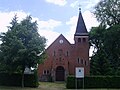
Freienhagen chapel


_chapel_NE_2015_02.JPG)
museum
The city of Liebenwalde received a district court in 1878. The old town hall was too small for that, so today's town hall was built in a very short time. Two years later, the city prison was built directly behind the town hall. In 1952 it was closed and then used as a storage room, coal cellar and archive. In 1997 the Liebenwalder Heimat- und Geschichtsverein e. V., primarily with the aim of setting up a museum in the now a listed but dilapidated building. With funding from the state and federal government and the support of craftsmen in the region, association members and many helpers, it was possible that the "Heimatmuseum Liebenwalde" could be opened in May 1999. Today the exhibition provides information about the city's history, the past of today's districts, about the history of churches, schools, clubs and the history of industry, handicrafts and trades. You can learn interesting facts about inland shipping, especially about the Finow Canal and the Niederbarnimer Eisenbahn-Aktiengesellschaft, known to many as the “Heidekrautbahn”.
Events
Annual events in Liebenwalde are the museum festival, the Easter fire, the museum night and the Christmas market, as well as the handball and football days with an extensive supporting program, the spring festival in the Liebenthal pet park and the slaughter festivals in the farm shops.
Economy and Infrastructure

traffic
Liebenwalde is located on the federal highway 167 between Neuruppin and Eberswalde and the state road L 21 between Zehdenick and Wensickendorf , which intersect in the city. The Deutsche Tonstraße runs through Liebenwalde and - coming from Kreuzbruch in the city and continuing on to Bischofswerder - the Berlin-Copenhagen long-distance cycle route .
The Voss Canal , which continues south of the city as the Malzer Canal and flows into the Oder-Havel Canal , is of importance for inland navigation .
Since the branch of the " Heidekrautbahn " between Wensickendorf and Liebenwalde, with the Liebenwalde and Kreuzbruch stations and the Sandberge stop, which ran from Basdorf to Liebenwalde, was closed in 1997, the place can only be reached by public transport by bus.
Public facilities
The fire protection of the city of Liebenwalde is ensured by a total of six fire departments in the individual districts. The tasks of the fire fighting train in Liebenwalde and the five fire fighting groups in the districts also include assistance and special operations. The city of Liebenwalde, as the fire protection agency, is responsible for the entire technology of the fire brigade and the financial support.
Sports
The football team of the FV Liebenwalde plays in the season 2019/20 in the county league Oberhavel / Barnim.
The handball club TSG Liebenwalde has existed since 1948.
Personalities
- Friedrich Wilhelm von Krause (1802–1877), wine merchant, private banker and industrialist, born in Liebenwalde
- Eduard Lisco (1879–1941), classical philologist and high school teacher, born in Liebenwalde
- Willy Sägebrecht (1904–1981), head of the NVA's military intelligence service , 1929–1930 city councilor in Liebenwalde
- Erika Franke (* 1954), General Staff Doctor in the Bundeswehr, grew up in Liebenwalde
Web links
- Website of the city of Liebenwalde
- Liebenwalde local family register
- Freienhagen in the RBB program Landschleicher on December 27, 2015
- Hammer in the RBB broadcast Landschleicher on February 11, 2018
Individual evidence
- ↑ Population in the State of Brandenburg according to municipalities, offices and municipalities not subject to official registration on December 31, 2019 (XLSX file; 223 KB) (updated official population figures) ( help on this ).
- ↑ Main statutes of the city of Liebenwalde from February 26, 2009 PDF
- ^ Service portal of the state administration Brandenburg - City of Liebenwalde
- ^ Project Liebenwalde. In: anthropologie-jungklaus.de. Retrieved June 4, 2017 .
- ^ Formation of a new town Liebenwalde, announcement of the Ministry of the Interior of November 14, 2002. Official Journal for Brandenburg Common Ministerial Gazette for the State of Brandenburg, Volume 14, 2003, Number 9, Potsdam, March 5, 2003, p. 273 PDF
- ↑ Fifth law on state-wide municipal reform concerning the districts of Barnim, Märkisch-Oderland, Oberhavel, Ostprignitz-Ruppin, Prignitz, Uckermark (5th GemGebRefGBbg) of March 24, 2003 Law and Ordinance Gazette for the State of Brandenburg, I (Laws), 2003, No. 05, p. 82, amended by the law of July 1, 2003 (Law and Ordinance Gazette for the State of Brandenburg, I (Laws), 2003, No. 10, p. 187)
- ^ Historical municipality register of the state of Brandenburg 1875 to 2005. Oberhavel district . Pp. 18-21
- ↑ Population in the state of Brandenburg from 1991 to 2015 according to independent cities, districts and municipalities , Table 7
- ^ Office for Statistics Berlin-Brandenburg (Ed.): Statistical report AI 7, A II 3, A III 3. Population development and population status in the state of Brandenburg (respective editions of the month of December)
- ↑ census database on zensus2011.de
- ^ Result of the local election on May 26, 2019
- ^ Local elections 1998. Mayoral elections on September 27, 1998 , p. 19
- ↑ Local elections October 26, 2003. Mayoral elections , p. 27
- ↑ Brandenburg Local Election Act, Section 74
- ^ Result of the mayoral election on September 1, 2019
- ↑ Coat of arms information on the service portal of the state administration of Brandenburg
- ^ Website of the Brandenburg Handball Association