
High country
| coat of arms | Germany map | |
|---|---|---|

|
Coordinates: 52 ° 42 ' N , 13 ° 55' E |
|
| Basic data | ||
| State : | Brandenburg | |
| County : | Märkisch-Oderland | |
| Office : | Falkenberg height | |
| Height : | 122 m above sea level NHN | |
| Area : | 53.93 km 2 | |
| Residents: | 1007 (Dec. 31, 2019) | |
| Population density : | 19 inhabitants per km 2 | |
| Postal code : | 16259 | |
| Primaries : | 033451, 033454 | |
| License plate : | MOL, FRW, SEE, SRB | |
| Community key : | 12 0 64 222 | |
| Community structure: | 3 districts | |
| Address of the municipal administration: |
Teichstrasse 5 (Leuenberg) 16259 Höhenland |
|
| Mayor : | Karsten Eschner | |
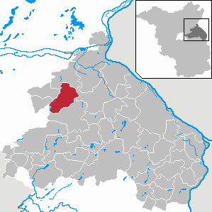
| Location of the municipality of Höhenland in the district of Märkisch-Oderland | ||
  |
||

The municipality of Höhenland is located in the Märkisch-Oderland district ( Brandenburg ). It is administered by the Falkenberg-Höhe office.
geography
Höhenland belongs to the so-called Freienwalder Barnimdörfern , as the place is on the Barnim plateau west of Bad Freienwalde (Oder) .
Community structure
The three districts belong to the municipality of Höhenland
- Leuenberg with 1847 ha,
- Steinbeck with 1378 ha (the area of the abandoned Dall Vorwerk is located in the district )
- Wölsickendorf-Wollenberg with 1011 ha (Wölsickendorf) and 1146 ha (Wollenberg).
Inhabited parts of the community are Wollenberg and Wölsickendorf, living spaces are expansion Tiefensee, train station, forge and Sternkrug.
history
Leuenberg, Steinbeck, Wölsickendorf and Wollenberg belonged to the Oberbarnim district in the province of Brandenburg since 1817 and to the Bad Freienwalde district in the GDR district of Frankfurt (Oder) from 1952 . Both places have been in the Brandenburg district of Märkisch-Oderland since 1993.
The voluntary amalgamation of the municipalities of Leuenberg and Steinbeck to form the municipality of Höhenland took place on May 1, 2002. The municipality of Wölsickendorf-Wollenberg was forcibly incorporated by law with the municipal election on October 26, 2003.
- Leuenberg was founded by Ritter von Löwenberg in the course of the east German settlement in the 13th century . There were also some Dutch and Flemish people among the first settlers - a hint is hidden in the place name, which used to be Leeuwenberg . The construction of the church (rectangular field stones, neat layering) indicates a time of origin in the 13th century. In the Middle Ages belonged Good on the field Mark the place for the possession of the Cistercian nuns - monastery Friedland . In 1432 the place was destroyed by the Hussites . From around 1450 Leuenberg was owned by the von Pfuel family . In 1618 the church received a clock bell with the inscription: " HANS VON PFUEL ISS HANS DIETLOFF VON PFUEL AN 1618 ". During the Thirty Years' War , Croats almost completely destroyed Leuenberg, and the church was burned down. In 1678, Lieutenant Colonel von Pfuel began the first reconstruction work. In 1687 Leuenberg fell to the Elector , who then handed it over to the von Lüderitz family . After the Thirty Years War, the windmill on the way to Heckelberg-Brunow was also rebuilt. The "old castle" was built in 1692. In 1695 a school was set up in Leuenberg, the first teacher of which was master tailor Georg Jänicke. At the beginning of the 18th century a plague of locusts ravaged the place. At this time in Leuenberg u. a. Bricks and tar made. In the Wars of Liberation from 1813 to 1815, nine Leuenbergers fell, three of whom are known by name: Behring, Belak and Tietze. A new church tower was built in 1855 by the carpenter W. Behring. The station, two kilometers away, was put into operation in 1898.
- Steinbeck: documentary mention of the knight's seat Stenbeke in 1375. From 1474 to 1661 Steinbeck was owned by the von Pfuel family.
- Wölsickendorf-Wollenberg: Wölsickendorf was first mentioned in 1375. The place used to be called Welskendorp or Welsekendorf . The church, which was built in the middle of the 13th century, is in need of renovation and is now a listed building . In 1639 Wölsickendorf came into the possession of the von Pfuel family. On October 1, 1961, the place was merged with Wollenberg.
Population development
| year | Leuenberg | Steinbeck | Wölsickendorf- Wollenberg |
year | High country | year | High country | ||
|---|---|---|---|---|---|---|---|---|---|
| 1964 | 501 | 344 | 581 | 2002 | 625 | 2015 | 1 026 | ||
| 1971 | 500 | 341 | 568 | 2003 | 1 073 | 2016 | 1 016 | ||
| 1990 | 354 | 215 | 384 | 2005 | 1 094 | 2017 | 1 014 | ||
| 1995 | 342 | 206 | 355 | 2010 | 1 029 | 2018 | 990 | ||
| 2000 | 382 | 230 | 452 | 2011 | 1 018 | 2019 | 1 007 | ||
| 2001 | 396 | 234 | 457 | 2012 | 1 020 | ||||
| 2002 | - | - | 448 | 2013 | 1 051 |
Territory of the respective year, number of inhabitants: as of December 31, from 2011 based on the 2011 census
politics
Community representation
The community council of Höhenland consists of 10 community representatives and the honorary mayor. The local election on May 26, 2019 resulted in the following distribution of seats:
| Party / group of voters | Seats |
|---|---|
| Voting group farmers and rural areas | 7th |
| CDU | 2 |
| Single applicant Frank Baptist | 1 |
mayor
- 2003-2008: Ingolf Schmidt
- 2008–2019: Helga Kowatzky (Action List Höhenland)
- since 2019: Karsten Eschner
Eschner was elected in the mayoral election on May 26, 2019 with no opposing candidate with 88.0% of the valid votes for a term of five years.
Attractions
The list of monuments in Höhenland includes the monuments entered in the list of monuments of the state of Brandenburg.
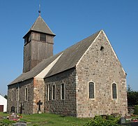
Leuenberg Church
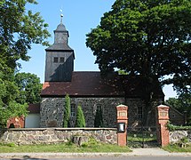
Wölsickendorf Church

Wölsickendorf manor house
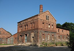
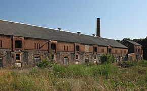
Former distillery Wölsickendorf
Wölsickendorf estate


traffic
Höhenland is located on the federal highway 158 between Werneuchen and Bad Freienwalde and on the state road L 341 between Heckelberg and Wriezen .

In Leuenberg there is a train station with which the place was connected from 1898 to Berlin , Wriezen and the more distant Königsberg in the Neumark (today: Chojna ) via the Wriezener Bahn . The section between Tiefensee and Wriezen, on which Leuenberg is located, has not been served since 1998. You can get to Berlin with the bus lines 887 and 882 of the Barnimer bus company , which go from Bad Freienwalde to Werneuchen, from Werneuchen you then continue with the regional train line RB25 to Berlin-Ostkreuz.
Personalities
- Katja Paryla (1940–2013), actress, lived in Wölsickendorf
swell
- ↑ Population in the State of Brandenburg according to municipalities, offices and municipalities not subject to official registration on December 31, 2019 (XLSX file; 223 KB) (updated official population figures) ( help on this ).
- ^ Service portal of the state administration Brandenburg. Municipality of Höhenland
- ↑ StBA: Changes in the municipalities in Germany, see 2002
- ^ StBA: Changes in the municipalities in Germany, see 2003
- ^ Village history . Retrieved April 6, 2017.
- ↑ Märkische Oderzeitung, September 19, 2005, p. 10
- ↑ M.Unterlauf: Local history and local chronicle of the community Leuenberg. Self-published, Leuenberg 1983.
- ↑ a b Leopold von Ledebur: Adelslexikon der Prussischen Monarchy . Rauh, 1856, pp. 196-197.
- ↑ Federal Statistical Office (Ed.): Municipalities 1994 and their changes since 01.01.1948 in the new federal states. Metzler-Poeschel publishing house, Stuttgart 1995, ISBN 3-8246-0321-7 .
- ^ Historical municipality register of the State of Brandenburg 1875 to 2005. Landkreis Märkisch-Oderland , pp. 22-25
- ↑ Population in the state of Brandenburg since 1991 by independent cities, districts and municipalities , Table 7, line 159
- ^ Office for Statistics Berlin-Brandenburg (Ed.): Statistical report AI 7, A II 3, A III 3. Population development and population status in the state of Brandenburg (respective editions of the month of December)
- ^ Result of the local election on May 26, 2019
- ↑ Local elections October 26, 2003. Mayoral elections , p. 26
- ↑ Local elections in the state of Brandenburg on September 28, 2008. Mayoral elections , p. 9
- ↑ Section 73 of the Brandenburg Local Election Act
- ^ Result of the mayoral election on May 26, 2019
- ^ Barnimer bus company. Retrieved June 15, 2017 .
- ^ Website of the spa town and mud spa Bad Freienwalde. Retrieved June 15, 2017 .
- ↑ mindwerk ag: City of Werneuchen - News from Werneuchen. Retrieved June 15, 2017 .
Web links
- Page about the community on the homepage of the Falkenberg-Höhe office
- Steinbeck in the RBB program Landschleicher on June 3, 2007
- Wölsickendorf-Wollenberg in the RBB program Landschleicher on August 7, 2005
Altlandsberg | Old cloth tape | Bad Freienwalde (Oder) | Beiersdorf-Freudenberg | Bleyen-Genschmar | Bliesdorf | Buckow (Märkische Schweiz) | Falkenberg | Falkenhagen (Mark) | Spruce height | Fredersdorf-Vogelsdorf | Garzau-Garzin | Golzow | Gusow-Platkow | Heckelberg-Brunow | Highlands | Hoppegarten | Küstriner Vorland | Lebus | Letschin | Lietzen | Lindendorf | Märkische Höhe | Müncheberg | Neuenhagen near Berlin | Neuhardenberg | New win | Neutrebbin | Oberbarnim | Oderaue | Petershagen / Eggersdorf | Podelzig | Prötzel | Rehfelde | Reichenow-Möglin | Riding wine | Rüdersdorf near Berlin | Seelow | Strausberg | Treplin | Vierlinden | Waldsieversdorf | Spices | Zechin | Zeschdorf