
Beiersdorf-Freudenberg
| coat of arms | Germany map | |
|---|---|---|

|
Coordinates: 52 ° 42 ' N , 13 ° 48' E |
|
| Basic data | ||
| State : | Brandenburg | |
| County : | Märkisch-Oderland | |
| Office : | Falkenberg height | |
| Height : | 85 m above sea level NHN | |
| Area : | 25.35 km 2 | |
| Residents: | 603 (Dec. 31, 2019) | |
| Population density : | 24 inhabitants per km 2 | |
| Postal code : | 16259 | |
| Area code : | 033451 | |
| License plate : | MOL, FRW, SEE, SRB | |
| Community key : | 12 0 64 053 | |
| LOCODE : | DE B7H | |
| Community structure: | 2 districts | |
| Office administration address: | Karl-Marx-Str. 2 16259 Falkenberg |
|
| Mayor : | Willi Huwe | |
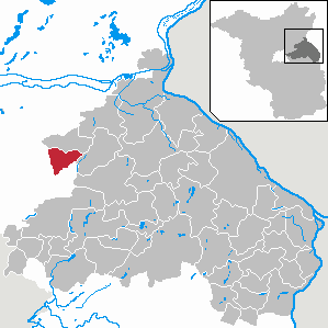
| Location of the municipality of Beiersdorf-Freudenberg in the Märkisch-Oderland district | ||
  |
||

Beiersdorf-Freudenberg is a municipality in the Märkisch-Oderland district in Brandenburg and part of the Falkenberg-Höhe office .

Community structure
The formerly independent communities of Beiersdorf and Freudenberg each form a district. In addition comes abode Beiersdorf expansion.
history
Freudenberg was formerly called Vrondenberg. It belonged to the Biesenhal district and shared the fate of Biesenthal and the villages that belonged to it. Its owner was Mathias von Uchtenhagen until 1427, who sold half of it for 400 shock Bohemian groschen to the brothers Klaus, Wilke and Otto von Arnim, who already owned the other half, presumably since the end of the 14th century. 1577 Elector Johann Georg took over from Franz von Arnim this fiefdom.
Beiersdorf and Freudenberg belonged to the Oberbarnim district in the province of Brandenburg since 1817 and to the Bad Freienwalde district in the GDR district of Frankfurt (Oder) from 1952 . Both places have been in the Brandenburg district of Märkisch-Oderland since 1993.
The community was created on December 31, 2001 from the voluntary amalgamation of the previously independent communities of Beiersdorf and Freudenberg.
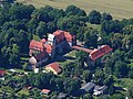
Freudenberg the headquarters of the so-called was until 1990 Department Blumberg of the Ministry of the Interior of the GDR with a panel of three connected by corridors bunkers bunker.
Population development
| year | Beiersdorf | Freudenberg | year | Beiersdorf- Freudenberg |
year | Beiersdorf- Freudenberg |
||
|---|---|---|---|---|---|---|---|---|
| 1875 | 524 | 536 | 2001 | 643 | 2017 | 606 | ||
| 1910 | 573 | 587 | 2005 | 631 | 2018 | 604 | ||
| 1939 | 483 | 464 | 2010 | 566 | 2019 | 603 | ||
| 1946 | 542 | 496 | 2011 | 569 | ||||
| 1950 | 585 | 516 | 2012 | 574 | ||||
| 1971 | 516 | 395 | 2013 | 594 | ||||
| 1990 | 377 | 310 | 2014 | 598 | ||||
| 1995 | 371 | 315 | 2015 | 593 | ||||
| 2000 | 372 | 282 | 2016 | 604 |
Territory of the respective year, number of inhabitants: as of December 31 (from 1991), from 2011 based on the 2011 census
politics
Community representation
The community council of Beiersdorf-Freudenberg consists of eight community representatives and the honorary mayor. The local election on May 26, 2019 resulted in the following distribution of seats:
| Voter group | Seats |
|---|---|
| WE together for Beiersdorf-Freudenberg | 2 |
| Voting group New impulses for Beiersdorf-Freudenberg | 1 |
| Individual applicant Ronald Buchholz | 1 |
| Individual applicant Wilfried Böttcher | 1 |
| Single applicant Simone Urbach | 1 |
| Single applicant Miriam Hollstein | 1 |
| Single applicant Victoria Petry | 1 |
mayor
- since 2003: Willi Huwe
In the mayoral election on May 26, 2019, Huwe was elected unopposed with 90.5% of the valid votes for a further term of five years.
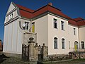
Attractions
The list of monuments in Beiersdorf-Freudenberg includes the monuments entered in the list of monuments of the State of Brandenburg.

- Manor house in Beiersdorf


traffic
Beiersdorf-Freudenberg is located on the L 236 state road between Schönfeld (district of Werneuchen ) and Leuenberg (district of Höhenland ). The federal road B 168 Eberswalde - Müncheberg crosses the municipality.
Personalities
- Karoline Balkow (1794–1872), writer, grew up in Beiersdorf
Individual evidence
- ↑ Population in the State of Brandenburg according to municipalities, offices and municipalities not subject to official registration on December 31, 2019 (XLSX file; 223 KB) (updated official population figures) ( help on this ).
- ^ Service portal of the state administration Brandenburg. Beiersdorf-Freudenberg community
- ↑ Landbuch der Mark Brandenburg and the Markgrafthum Nieder-Lausitz in the middle of the 19th century. Second volume. Brandenburg. 1855. pp. 322, 376
- ↑ Name and boundary changes of the municipalities. (XLS 169 KB) 2001: January 1st to December 31st. (No longer available online.) Federal Statistical Office , archived from the original on November 14, 2010 ; Retrieved October 3, 2011 .
- ^ Historical municipality register of the state of Brandenburg 1875 to 2005. Landkreis Märkisch-Oderland . Pp. 18-21
- ↑ Population in the state of Brandenburg from 1991 to 2015 according to independent cities, districts and municipalities , Table 7
- ^ Office for Statistics Berlin-Brandenburg (Ed.): Statistical report AI 7, A II 3, A III 3. Population development and population status in the state of Brandenburg (respective editions of the month of December)
- ^ Result of the local election on May 26, 2019
- ↑ Local elections October 26, 2003. Mayoral elections , p. 25
- ↑ Section 73 of the Brandenburg Local Election Act
- ^ Result of the mayoral election on May 26, 2019
Web links
Altlandsberg | Old cloth tape | Bad Freienwalde (Oder) | Beiersdorf-Freudenberg | Bleyen-Genschmar | Bliesdorf | Buckow (Märkische Schweiz) | Falkenberg | Falkenhagen (Mark) | Spruce height | Fredersdorf-Vogelsdorf | Garzau-Garzin | Golzow | Gusow-Platkow | Heckelberg-Brunow | Highlands | Hoppegarten | Küstriner Vorland | Lebus | Letschin | Lietzen | Lindendorf | Märkische Höhe | Müncheberg | Neuenhagen near Berlin | Neuhardenberg | New win | Neutrebbin | Oberbarnim | Oderaue | Petershagen / Eggersdorf | Podelzig | Prötzel | Rehfelde | Reichenow-Möglin | Riding wine | Rüdersdorf near Berlin | Seelow | Strausberg | Treplin | Vierlinden | Waldsieversdorf | Spices | Zechin | Zeschdorf