Alt-Mariendorf
| Alt-Mariendorf | |
|---|---|
| Street in Berlin | |
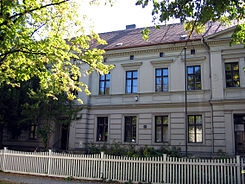
| Tempelhof Museum in Alt-Mariendorf 43 | |
| Basic data | |
| place | Berlin |
| District | Mariendorf |
| Created | August 31, 1949 |
| Connecting roads | Rathausstrasse (west), Rixdorfer Strasse (east) |
| Cross streets | Forddamm, Upstalweg, Mariendorfer Damm , Am Heidefriedhof |
| Buildings | Tempelhof Museum (local history museum), Volkspark Mariendorf , village church Mariendorf , churchyard Mariendorf II |
| use | |
| User groups | Pedestrian traffic , bicycle traffic , car traffic , public transport |
| Technical specifications | |
| Street length | 950 meters |
Alt-Marie village , the former village street was founded in the 13th century street village and today's Berlin hamlet Marie village , is now a main road in Tempelhof-Schöneberg . The old village center is a listed building.
Location and development
On the Alt-Mariendorf street there are now single-storey former farmhouses - such as Alt-Mariendorf 42, which was used as a pub - as well as multi-storey old buildings from the Wilhelminian era . At the east end of the street are some residential buildings from the 1970s. The Alt-Mariendorf street represents the approximate boundary between closed development in the northern part and open development in the southern part of Mariendorf.
The local history museum of the district was set up in the old school building at Alt-Mariendorf 43 in 1960 , today the Tempelhof Museum . To the north of Alt-Mariendorf and east of Mariendorfer Damm is the Volkspark Mariendorf, inaugurated in 1931 . On the southern side of Alt-Mariendorf there is the churchyard Mariendorf II next to the village church Mariendorf and to the south-east, on the Reißeckstraße, the heather cemetery .
traffic
The old village street Alt-Mariendorf was converted into a partly five - lane one-way street after tram line 15 was closed in 1966 . It directs traffic in an east-west direction from Rixdorfer Strasse and Britzer Strasse from the direction of Neukölln and its district of Britz in the direction of Steglitz , Lankwitz and Marienfelde . The traffic flows in the opposite direction via Friedensstrasse and Reißeckstrasse.
The intersection Alt-Marie Village / corner Marie Damm (part of extending in the north-south direction Federal Highway 96 ) is suitable for the individual traffic as well as for public transport a significant traffic junction . The Alt-Mariendorf underground station has been located here since 1966 , where the U6 underground line from the north ends. There are also several bus routes that connect the southern districts of Berlin in particular. A tram (line 99) stopped here between 1887 and 1961 .
The southwest direction over Marienfelde to Aue leading national road 101 begins at the western end of the former Street Village at Großbeerenstraße.
Mariendorf village church
The village church Mariendorf in the middle of the village was built in the first half of the 13th century. It is the church of the Protestant parish Berlin-Mariendorf.
Web links
- Alt-Mariendorf. In: Street name lexicon of the Luisenstädtischer Bildungsverein (near Kaupert )
- Website of the Tempelhof Museum
- Chronicle of the village church Mariendorf
Individual evidence
- ↑ Ensemble of the Mariendorf settlement core
- ↑ Photo of Alt-Mariendorf approx. 1966 with tram see Tram Forum ( memento from January 6, 2013 in the web archive archive.today ), 6th picture from above
Coordinates: 52 ° 26 ′ 24 ″ N , 13 ° 23 ′ 12 ″ E


